BWCA Entry Point, Route, and Trip Report Blog
June 09 2026
Entry Point 39 - Baker Lake

Number of Permits per Day: 2
Elevation: 1497 feet
Latitude: 47.8452
Longitude: -90.8169
Summary: A 5-day loop from Baker up the Temperance lakes to Cherokee, and back through Sawbill and Smoke lakes back to Baker. A fairly difficult trip.

Day 0: We drove up from Stillwater in the morning and camped at one of the 5 walk-in campsites at Baker Lake, and it was nice.


Day 1 (Baker to S. Temperance) - A beautiful day, we decided to paddle all the way to South Temperance the first day which was a great paddle with easy portages except for the last one. We picked the campsite on top of a huge rock that was close to the middle of the lake. Tried fishing some but no luck


Day 2 (Rest) - In the night, we encountered the worst storm of the entire season. While we were there 19 people had to be rescued from the BWCA. We had about 50mph straightline winds, and I'm still surprised that the huge tent we had stood up to it. We slept in and took a rest day because of the intense winds. Amazingly beautiful sunset.


Day 3 (S. Temperance to Cherokee) - We left as early as we could to beat the heat, but it was no good. The lengthy, hilly portages were challenging and by the last portage we were pretty beat. We overpacked and single portaged which led us to speedier exhaustion. Still amazing weather. North Temperance was a beaut- I wish we had stayed there instead of South. We took the southeasterly facing campsite on Cherokee on the southeastern skinny island. Neat little site.

Day 4 (Cherokee to Sawbill) - Left a little later in the day but it was ok. We took our time going down the river letting out of the southwest part of Cherokee and it was a great area. BEWARE: The area between Ada and Skoop Lakes appears to be floatable, but a dam built recently has made the portion impossible to float. Be prepared for a long portage through muck and water. A guy that we saw there said he had been going to the BWCA for 40 years at least once per year and it was the worst portage he had ever seen. By the time we got to Sawbill it was pretty hot. We paddled all the way down to the site next to the portage onto Smoke.

Day 5 (Sawbill to Baker) - Cooler, cloudier weather for the first time on the trip. We were pretty hungry (I underpacked food a little and I felt really bad) and we were taunting each other with vivid descriptions of the burgers we were going to eat ASAP after getting out. We paddled back to Baker and returned our gear to Sawtooth outfitters.
Overall great route.
Frost River Loop out of Baker Lake
Entry Date:
July 29, 2012
Entry Point:
Baker Lake
Number of Days:
6
Group Size:
2
We spent our first night on South Temperance Lake and were lucky enough to have a nice view from the campsite up on the rock on the south side of the lake. We put up camp and were relaxing when a canoe came to the landing at the bottom of the campsite waving at us in greeting and two guys got out. We thought that they probably wanted to eat their lunch. After ten minutes or so they carried up their canoe. At that time I thought it was appropriate to ask what they were up to. They said they were doing a portage. After helping them find their way, we had the camp to ourselves again. During the afternoon and night we had 3 waves of thunderstorms going over that collapsed our tarp. Luckily, our tent stayed dry.
The next morning we paddled east to Brule which was on her normal behavior whipping up waves even at the early hour. North then west along the rocky and that day slippery portages toward Cherokee Lake. Our single portaging came to an end because the poor footing and balancing were just too much. At the end of the portage into Towne Lake we ran into a father/son team on their way to Brule. They were single portaging in open-toe sandals. After they asked how the portages were we informed them that they were 'pretty rocky'. They did have boots with them to change into should the need arise. Being pretty worn out we were glad to find the only campsite on Towne open. 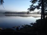
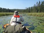 The next day took us to Frost Lake and the Frost River. The camp on Bologna Lake was available. Unfortunately it was pretty brushy and mosquito infested. Like the afternoon and night before we saw groups that were looking for a campsite late in the day. In the case of the Frost River that is bad news. It's a good long trip either way to the next one.
Day 4 took us the rest of the way down the river and we ended up on Mesaba Lake. It was pretty warm and a swim was in order. Having been in my birthday suit I fled into camp when I saw a canoe approaching. They headed for the campsite across the arm, looked around, got back into their canoe, and headed straight for ours which was clearly flagged as occupied with a tarp and the laundry flapping in the wind. My wife fled into the woods. The canoe docked and the two young ladies identified themselves as US Forest Service rangers. I asked them to wait until I was 'decent', which they were more than happy to do. After checking our permit, the fire grate and latrine, and a couple questions about downed trees along the portages they were on their way.
The following day took us south along the long but relatively easy Zenith-Lujenida portage along the Kelso River to Sawbill Lake. Along the Z-L portage we came across footprints of a sow and her cub. On Sawbill we camped near the portage to Burnt Lake. It's a nice spacious camp and while Sawbill is a busy place during the day, the night was very quiet because the campsites are concentrated along the north end.
As always, our trip came to too early an end the next day when we paddled back to Baker.
The Boundary Waters seemed to be pretty busy this year even after putting some portages between us and the entry points. Many people had to go farther than anticipated to find a campsite for the night. Obviously it was early August, but that is our usual time. It definitely was a good thing to get up early and make camp early as well.
We can't wait till next time. With a 12 hour drive and limited vacation time it will be another year before we can be back.