Boundary Waters, Routes, Forum, BWCA, BWCAW, Quetico Parkwww.BWCA.com Trip Reports - Messageboard, Forum, BWCA, BWCAW, Quetico Park
Boundary Waters Route Blog
    Trip Reports
      Trip Report - Big Slim
 
  Last Visit: 04/18/2024 12:57AM

Entry Point 7 - From Big Lake

Big Lake entry point allows overnight paddle only. This entry point is supported by Kawishiwi Ranger Station near the city of Ely, MN. The distance from ranger station to entry point is 28 miles. Access La Pond Lake with a 160-rod portage from outside the BWCAW on Big Lake. This area was affected by blowdown in 1999.

Number of Permits per Day: 2
Elevation: 1161 feet
Latitude: 48.0651
Longitude: -92.0188
Author Message Text
TuscaroraBorealis
distinguished memberdistinguished memberdistinguished memberdistinguished member
 
06/28/2013 02:51PM
 
New Trip Report posted by TuscaroraBorealis

Trip Name: Big Slim.

Entry Point: 7

Click Here to View Trip Report
Reply Top Bottom Previous Next
dicecupmaker
distinguished memberdistinguished memberdistinguished memberdistinguished member
 
06/29/2013 05:01AM
 
Another great trip report. Always enjoy your reads!

Joy is a great teacher, but so is dispair. Wonder is a great teacher, but so is confusion. Hope is a great teacher, but so is disillusionment. And life is a great teacher, but so is death. To deny yourself any of those in any aspect is not experiencing life totally.
TuscaroraBorealis
distinguished memberdistinguished memberdistinguished memberdistinguished member
 
06/29/2013 08:18AM
 
quote dicecupmaker: "Another great trip report. Always enjoy your reads!"


Thanks Mitch.
Ho Ho
distinguished memberdistinguished memberdistinguished memberdistinguished member
 
06/29/2013 01:20PM


Thanks for the excellent report, TB. You were in my backyard on this trip - BUT, I have never paddled several of those lakes, namely Laplond, Big Rice, and Duck. Now I want to camp on Big Rice - though probably not until next spring because I think you guys probably picked the perfect time of year for that area.

Several years ago, at the beginning of May, David and I camped on Slim (the northern site, which you rightly said was only so-so) and did a day trip to Hook and then hiked the portage round-trip to Big Rice. That was a memorable experience and I agree it's a really interesting portage. You are one of the very few people I've heard of who have actually portaged it. BTW, as you hiked through, did you notice the old blazes on the trees marking the way? We found them very helpful, as we did lose the path a few times on our hike, and the blazes helped reassure us when we were going the right way.

I've been on Big Moose Lake a bunch of times this year, both camping and day trips, because I'm doing a breeding bird survey there. On my two overnight trips, both in May, I hiked (and birded) part of the portage to Duck, but both times I turned around at Duck Creek because the amount of water pouring through there made it look dangerous to cross the creek. This was not long after ice out, and you could tell there were big boulders in the rushing bog-stained water, but the bog stain made it hard to assess the footing. By the time you guys got there, I think water levels were more moderate (believe it or not, they were higher in May) and also the water was warmer. I'm curious, though, did you have any problem crossing the creek? Maybe I'll finally get across it when I head back to Big Moose for another overnight trip in July.

Thanks again for the report.

Ho Ho


AndySG
distinguished memberdistinguished memberdistinguished memberdistinguished member
 
06/29/2013 01:22PM
 
Very nice report Paul. I always enjoy your descriptions and pictures. The Slim, Rice, Hook area is where I did my first solo, so I enjoyed your perspective on the area.
TuscaroraBorealis
distinguished memberdistinguished memberdistinguished memberdistinguished member
 
06/30/2013 10:35AM
 
Ho Ho,


The duck creek crossing was a little tricky. There was more water flowing than the last time, but there were enough exposed rocks to hopscotch across. I'll try to upload the photo when I get back home next week.
Ho Ho
distinguished memberdistinguished memberdistinguished memberdistinguished member
 
06/30/2013 10:40PM


Thanks, I'd love to see the pic.


boonie
distinguished memberdistinguished memberdistinguished memberdistinguished member
 
07/01/2013 06:14AM
 
quote dicecupmaker: "Another great trip report. Always enjoy your reads!"


+1
muddy
distinguished memberdistinguished memberdistinguished memberdistinguished member
 
07/01/2013 07:50AM
 
Nice read..thanks!
paddlefamily
distinguished memberdistinguished memberdistinguished memberdistinguished member
 
07/03/2013 03:51PM
 
Thanks for sharing your report. My husband and I along with our kids took a day trip from Slim to Rice a few years back. Wish I'd known about Ol' Baldy as it sounded like a scenic side trip. Pretty area for sure.
mcsweem
distinguished memberdistinguished memberdistinguished memberdistinguished member
 
07/03/2013 07:40PM
 
Another great trip report. Great photos too
TuscaroraBorealis
distinguished memberdistinguished memberdistinguished memberdistinguished member
 
07/07/2013 07:21PM
 
quote Ho Ho: "


Thanks, I'd love to see the pic.


"


Looking west from the trail.


Looking north from where the trail crosses.


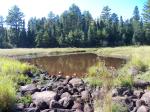
Same pond as second picture. This was taken in September 2011 when we crossed. Creek was nearly bone dry.
SevenofNine
distinguished memberdistinguished memberdistinguished memberdistinguished member
 
07/09/2013 08:44AM
 
Paul, nice trip report. Makes me want to cover that area.

The best part of this journey here is further knowing yourself - Alan Kay
Ho Ho
distinguished memberdistinguished memberdistinguished memberdistinguished member
 
07/09/2013 01:54PM
 
Thanks for the pics! Very informative. All those boulders sticking out of the water in the first two pictures (and even more in the third picture from 2011) were UNDER very fast moving water when we were there in May, which is why I thought it seemed too hard to cross the creek. I'd cross it with the boulders exposed like they are in your pictures, especially on a dayhike like we've been doing. It would still take some coordination with a canoe or heavy pack, but it would be doable. Anyway, I'll have to go back and cross it later this summer. (I might wait for the bugs to tamp down, though - I just got back from Quetico and they were the worst I've seen in dozens of Q and BW trips.)


TuscaroraBorealis
distinguished memberdistinguished memberdistinguished memberdistinguished member
 
07/10/2013 03:59PM
 
Greg,


Since fishing really isn't your thing - I kinda figured this area might be of particular interest to you.
Zulu
distinguished memberdistinguished memberdistinguished memberdistinguished member
 
07/10/2013 09:33PM
 
Thanks for the great report and photos TB! I have always wondered what that area was like. Your descriptions and photos really help us understand what it must be like to take that route.
TuscaroraBorealis
distinguished memberdistinguished memberdistinguished memberdistinguished member
 
09/06/2017 03:52PM
 
After hastily planning a last second trip to canoe country on a holiday weekend proved to be a futile affair; as (not unpredictably) virtually all permits were claimed. So, we settled on visiting Big Lake. It serves as the launching point for EP #7 but, the lake only borders the protected wilderness, so no permit is necessary to camp there. As it's name suggests it is a big lake but, there are a multitude of islands and bays that deceptively conceal its size and beautifully enhance the shorescape.


Aurora's cousin Logan would be joining us on this adventure. It would be his first canoe trip and first time away from Mom & Dad. Consequently the first night was a bit tough but, I'm happy to say things got progressively better and he was closer to the happy go lucky kid we've come to know by the last evening. Both Aurora & Logan had a blast exploring, fishing, canoeing, swinging in the hammock etc. They even found a salamander they named "Johnny".


Going in, we had some concern about campsite availability (as there are only four official sites on the lake. Those worries were for naught as there were several unofficial sites around the lake. All had fire rings and some had makeshift latrines. We were fortunate to be able to claim the southern site on the large island which I'd rate a 5 star. Great peninsula site with a canopy of nicely spaced pines peppered throughout the site. Several spacious (and flat) tent pads, and trails for exploration. Great views as well.


Of course it wasn't a true wilderness getaway; as there were motor boats about and there are 2 resorts/outfitters on the lake. Still, it offers a satisfactory experience when other options are not available.
Reply Top Bottom Previous Next
Routes
Trip Reports
a
.
Routes
Trip Reports
Routes
Trip Reports
Routes
Trip Reports
Routes
Trip Reports
.
Routes
Trip Reports
Routes
Trip Reports
x
Routes
Trip Reports
fd
hgc
Routes
Trip Reports
Routes
Trip Reports
Routes
Trip Reports
Routes
Trip Reports
Routes
Trip Reports