|
 Boundary Waters Quetico ForumListening Point - General Discussion Ram Lake hiking trail???
|
 Forum Sponsor

Author
Text
")


06/13/2018 09:15AM
Does anyone know of a hiking trail that accesses Ram Lake EP #44?
We did a trip there a couple weeks back and found a swath cut through the woods from the south end of the lake and running south. We didn't follow it to it's origination/termination point but, did hike it for several hundred yards to the top of the ridge around Ram Lake and seen that it continue south for as far as the eye could see.
There was a continuous swath (lots of little stumps) cut through the forest that was approximately 15-20' feet wide. I realize that since Ram Lake is literally right on the wilderness boundary this MAY not be technically be inside the BWCAW. Still, it runs right up to the lake!
I've never heard or read anything about what or why this may be here. Wondering if anyone else might know anything about this???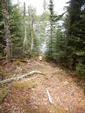

The rest of our adventure
We did a trip there a couple weeks back and found a swath cut through the woods from the south end of the lake and running south. We didn't follow it to it's origination/termination point but, did hike it for several hundred yards to the top of the ridge around Ram Lake and seen that it continue south for as far as the eye could see.
There was a continuous swath (lots of little stumps) cut through the forest that was approximately 15-20' feet wide. I realize that since Ram Lake is literally right on the wilderness boundary this MAY not be technically be inside the BWCAW. Still, it runs right up to the lake!
I've never heard or read anything about what or why this may be here. Wondering if anyone else might know anything about this???


The rest of our adventure
06/13/2018 10:05AM
I think what you encountered was the wilderness boundary. It cuts across the eastern tip of the lake. The eastern campsite on Ram is actually outside the wilderness. It is still Superior National Forest, but outside the BWCAW.
The metal pipe is a survey marker. Looks rather new or at least recently cleaned up.
The question one might ask. Could travel to that campsite on a day use permit and stay there overnight. To travel on the lake you would have to have a day use permit for each day you are there, but you could camp at that site without an overnight permit. Sounds like a lousy site, however.
This is all based on the maps provided by this website. I'll check other wilderness boundary maps when I get a chance.
06/13/2018 03:28PM
I just perused the Cook County plat map and found that land is owned by the feds.
Perhaps a call to the Gunflint Ranger Station may get you an answer?
(I assume the except part lying within 400' of Ram Lake is due to that being within the BWCAW boundary.)
Summary Legal Description: NW1/4 EX PART LYING WITHIN 400' OF RAM LAKE; SW1/4; SE1/4
Deeded Acres: 431.94 AC
Assessed Frontage: 0.00 FT
Lake: RAM
Homestead: No
Location: Section: 10 Township: 63 Range: 1 W
06/13/2018 09:00PM
I’ve Fished Ram and camped on both sites.Where exactly is this path? It wasn’t there 4 years ago when I was there last.
My guess is snowmobiles and the winter crowd may have done it. People access it with sleds off S. Brule Rd. Which isn’t plowed back too far off the Gunflint but is used as a non groomed snowmobile trail.
Maybe someone is challenging where exactly the official BWCA boundary is? Same folks as the McFarland-Fowl Lakes crew? Guessing?
The further north I go, the warmer I feel.
06/14/2018 06:25AM
MackinawTrout: "I’ve Fished Ram and camped on both sites.Where exactly is this path? "
The 'swath' starts/ends in the extreme SE corner of Ram lake. The other trsils can be accessed from the entry point portage, at the top of the stone staircase leading down to the lakeshore.

Subscribe to Thread
Become a member of the bwca.com community to subscribe to thread and get email updates when new posts are added. Sign up Here
 Search BWCA.com
 Donate