|
12/20/2007 11:48AM |
Looking at Google Earth suggests that the road disappears here and there around Phantom (and in other places). I would expect the old road to grow over very quickly in low areas. In other places the road seems very pronounced.
A couple of times the wind made it impossible to get across Cummings so we would take the 'southern route' through Lunetta.
From posts I've read, I seems that Western has changed. 'Surrounded by a sunken forest of dead spruce' and the beautiful camp site 'burnt over'. It also sounds like beaver have raised the lake level and mucked up the portage from Buck.
Still the dream and challenge to 'Walk to Western' is strong! Any more information out there?
|
12/20/2007 02:12PM |
Seriously, I'm occasionally directionally challenged, so would only try this trip if I had a GPS safety blanket. I also just read "Lost in the Wild" .... faint disappearing logging roads and swampy areas can be a potion for trouble.
|
05/10/2008 07:03PM |
My brother and I completed our hiking May 5 through May 9.
We bushwhacked from a logging parking area just next to the gate on Wolf Lake Road. We walked to avoid private land and joined the old road after about 1.3 mile. (The hike from the campsite on Phantom to the car coming out was 3.4 miles and took about 3 hours.)
We camped at the designated campsite on Phantom Lake. (We had a BWCA travel permit - one canoe cause they don't issue hiking permits for this area although the personnel knew we were hiking.) Burntside was still icebound.
We got as far north as the middle Schlamn Lake - Lunetta Lake Portage. The portage cross a rather brisk and deep (about 2 canoe lengths wide) stream at that point. I wonder what canoeists do to keep dry feet.
The next day hiked south to the BWCA border. Then we found a trail over to Meat Lake and thence to Clark. From this excursion, I realized that in the past I got to Meat not from the Wolf Lake Road, but from the Clark Lake Road.
On the third day we got as far west as Soroll Lake.
The trail/road is easy to follow. Windfalls have been cut (except for the past winter's, I presume.) Obvious the old roads have not been unused in the past 30 years.
We hiked about 10 miles per day.
In some swampy places the trail has sunk which means you face walking in a trough of water of crashing bush to keep to the berm.
We had wonderful weather for hiking. Only rain one night.
I must admit we kept a leisurely pace usually not getting out on the trail until between 10:30 and noon!
I get a fuller report together with photographs when I have the time.
Thanks for your help here.


|
10/02/2018 10:27AM |
The Great Outdoors: "moheep,
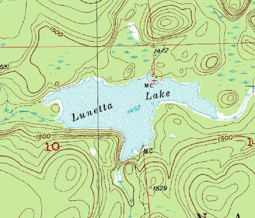
The map Ken supplied shows the location of the Lunetta cabin.
I believe it was removed after the 1964 Wilderness Act.
It was owned by Henry Niemi who spent the entire summer on the lake. When paddling by, you could hear him singing Finnish songs while he worked on whatever project he chose to do that day. As I wrote in an earlier post, one project was the building of a trail from his cabin to Cummings Lake. Not just cutting a trail, but smoothing it out and using sand and rocks when necessary to make it nice. I don't know if any recognizable portion of it exists today.
His wife stayed in Ely and ran the Trading Post, a store that sold Indian trinkets, clothing,postcards, and a few other items. I believe she was part Native American.
You'd have to have been familiar with Ely in the late 50's to remember the Trading Post as it was located on Chapman street, directly across from the Ace Hardware parking lot.
Henry was the grandfather of a friend of mine. We'd go to his basement apartment to get cookies from Grandma Niemi (never knew her first name. Of course back then it would have been Mrs. or grandma. You wouldn't have sat down for a long time if you called her anything else:)
Henry (Mr. Niemi) would only be home in the winter. I was always scared of him when we went on a cookie run, he never talked much, just grunted and always sat in a dark room on a rocking chair so you could never quite make out his face. As I think back, he could have been on some type of witness protection program:)
Their daughter passed away several months ago, the 3 grandsons and 1 grand daughter still live in town. My friend which would have been the oldest grandson, died in a mining company accident in 1970.
"
I read this thread before my trip into the area two weeks ago. I went looking for any remains of the cabin on Lunetta and found a few random pieces of siding, a wood sign that seemed to have had a tree grow around it (picture below, not sure if this is from the days of the cabin or after), and most significantly the reamains of this rock wall (picture below). No signs of the trail that he cut up to Cummings though. Was also wondering if he had a cold storage in the ground or a garden? Seemed there might have been some evidence of these as well.


|
05/16/2008 01:55PM |
Phantom Lake Bushwhack
. Thanks to all for you information and encouragement.
Ken
|
05/16/2008 09:54PM |
|
05/16/2008 03:03PM |
I'm intrigued by the fact that the old roads are obviously being cleared of windfalls. I really noticed this when portaging from Battle to Phantom Lakes and from Phantom to Sprite in September 2006. I figured people were using them as illegal ATV trails. But it sounds like you think maybe snowmobiles? Or just (perfectly legal) walking routes for hunters? Anyway, I'm going to explore sometime - maybe paddle in and walk from there.
We were camped at Keneu Lake on Thursday (you're last night in) on an overnight paddle from Slim EP. Got nice and cold! Wolves howled at night and the morning. Did you encounter any?
|
05/16/2008 03:22PM |
The trip raised more questions than answers. The windfall removal seemed to be make in the manner of a portage worker done with a hand saw. Two cuts and rolling the piece out of the way rather than that of a chain sawyer (many cuts and smaller pieces.) I'd bet a beer on no ATV's however I'd bet a case of beer on winter snowmobile use. The winter campsite convinced me of that.
We had rather cold nights. Thursday morning we notice a skim of ice on a small pond along side the trail. Except for the rain Tuesday night we had wonderful weather.
Have you ever been over the Lunetta to Schlamn portages? I am wondering how folks manage Schlamn Creek bisecting the portage? Perhaps the creek is not so swollen after the spring melt during the summer.
Maybe next time I will canoe to Lunetta and go north from the middle schlamn portage.
Actually the Bushwhack from the logging site to the trail/road was one of the better parts of the trip. The forest was positively gorgeous.
Ken
|
12/20/2007 10:40PM |
The area, if I remember correctly was being cut in the 60's.
I went deer hunting up there while home on leave from the Army in 1968.
Two of us shot deer east of the logging road, just before Schlamn creek.
This area had already been logged, we shot them in the slash that was left.
The logger in the area was Winegartner (sp) The portal zone still existed at this time.
This area is very grown in, and will be nothing like you remember.
Best to take the portages, as they are bad enough:)
PS-You must also cross private land to walk the "Old Wolf Lake Road" anywhere past Foss Lake.
|
12/21/2007 08:26AM |
You anticipated part of my next question: Access along the Wolf Lake Road.
We had contemplated a scouting trip with Cross country skies once the snow hardened up in late winter. I wondered how far the road was open in the winter.
Sounds like you say it is basically a private road from Foss lake on?
|
04/22/2008 09:14AM |
I have a entry permit into Crab Lake for May 5th since that seems the only legitimate way of accessing the old logging roads.
(Probably by Schlamn Lake. I would prefer to access the road at Phantom Lake, but reports say that the Crab-Clark-Meat etc portages are not maintained.)
The delayed spring (or perhaps it's really just a normal spring) has me anxious that Burntside will still be iced over. My bother and I plan to scout out various aspects of this trip in Ely this weekend.
The stated goal of this trip is Western Lake on foot. Realistically we will be satisfied for some nice spring days in the wilderness.
(We have a summer canoe trip planned for early August which will get us into Western the 'normal' way.)
So does anyone have any fresh information on this old Portal Zone?
Ken
|
05/16/2008 06:43PM |
I love this time of year in the BW because of the way the forest is. It's a great time to hike on portages or bushwhack some.
|
05/16/2008 07:47PM |
Did you find the '55 Chev in the woods by the old logging camp site???
|
04/22/2008 11:11AM |
For what it's worth, I think the ice will be out by May 5.
|
04/22/2008 11:00PM |
What did you want to know about the portal zone??
|
04/24/2008 07:51AM |
|
12/20/2007 04:00PM |
I am only considering this Bushwhack because I figure the old roads might provide a 'path with less resistance'. I tentatively plan to add a lot of mileage (double - total near 10 to 11) than a 'bee-line' (5 to 6) to Western through swamps and thickets.
As I understand it this area was cut-over in the 1970's, so I expect no 'majestic pine cathedrals'. I doubt this area was re-planted. So what kind of forest will I find in there now?
|
12/21/2007 09:57PM |
Much of the Wolf Lake Road from Foss lake on has always been on private land.
From the start of Tamarack Lake on, was all private, until you got further towards Phantom.
Easements were granted for logging years back, and people (fishermen & hunters) continued to use the road without the land owners objecting.
Gates have now been put up because some of the property owners have had run ins with people that left a bad taste in their mouth.
If the lakes are open at the time of your trip, which is possible, you may have your best luck canoeing across Big Crab, Little Crab, down the creek to Lunetta.
On the portage from Lunetta to Schlamn, you will cross the Wolf Lake Road.
You could stash the canoe, and begin to hike the route to Western. Get some good maps with GPS data. Then return to your canoe and paddle back out.
I traveled the area quite a bit, way back then, & made my 1st trip into Western (through Schlamn and Glenmore)in 1962, at age 14.
Where are you from that you knew of this area, as not many did in those days.
|
12/21/2007 09:26AM |
No I'm not familiar with that exact area so I can't tell you how grown over the "old Wolf Lake Road" is now. I have hunted a lot about 5-10 miles from there. Even though there was a rough road there at one point doesn't mean you won't be bushwhacking through some thick woods now. I'm sure you will do just fine as it appears you have done your research. Good luck.
pickle
|
12/22/2007 10:44AM |
Your suggestion about canoing part of the way was plan B forming if using the Wolf Lake Road was not possible.
I lived in Ely from 73 to 82 and have returned often. (I live in Cloquet just outside Duluth.)
I 'stumbled' across Western during a trip in the 70's. I went with a couple of my brother's rowdy friends. I believe we came down the Little Indian Sioux River. The trip was memorable for a couple of reasons. 1. One guy used the latrine and put the toilet paper in his back pocket (with the plastic bag not closed). He liked to jump in and out of the canoe. Well, he wiped out 1/2 our toilet paper supply. That quickly became a problem. So bad we tried to dry the toilet paper over a fire!!!
2. We discovered Western Lake. We dropped some fishing lines in the lake during lunch and caught some beautiful walleye, which then became lunch. We hooked fish; the lake hooked us. We had one evening of fishing catching Walleye with only having the smallest bits of bait. We caught them as fast as we could clear our hooks. Many, many went back into the lake - a few became a late supper.
I visited Western more than a dozen times during those years.
We also discovered Sorol Lake (south of Glenmore). It was a extremely clear, deep lake filled with large Northern Pike. We would catch and release just to watch the lunkers dart in after the bait. Of course, we always SAW bigger fish going after our bait that we actually hauled out of the water. But fishermen do tell tales.
Ken
|
12/22/2007 09:23PM |
If my memory serves me correctly, there was a proposal to put a path to be used by horses very close to, if not the same area, you show.
This was 20 years ago or more, and think that Howard Wagoner from Tower was the one originating the idea just before or after retiring from the DNR.
The horse is considered to be a dray animal, which isn't allowed in the BWCA, so the trail never materialized.
If you get a chance, give me a call at my shop tomorrow between 12 and 2. (218-365-4744) Your name is very familiar, & am interested in finding out more about your time in Ely.
An old timer that lived in the only cabin on Lunetta in the summers, Henry Niemi, built a trail with pick, shovel, and wheelburrow from his shack to Cummings. Ever hear of him???
|
12/22/2007 09:48PM |
|
12/23/2007 10:32PM |
The map Ken supplied shows the location of the Lunetta cabin.
I believe it was removed after the 1964 Wilderness Act.
It was owned by Henry Niemi who spent the entire summer on the lake. When paddling by, you could hear him singing Finnish songs while he worked on whatever project he chose to do that day. As I wrote in an earlier post, one project was the building of a trail from his cabin to Cummings Lake. Not just cutting a trail, but smoothing it out and using sand and rocks when necessary to make it nice. I don't know if any recognizable portion of it exists today.
His wife stayed in Ely and ran the Trading Post, a store that sold Indian trinkets, clothing,postcards, and a few other items. I believe she was part Native American.
You'd have to have been familiar with Ely in the late 50's to remember the Trading Post as it was located on Chapman street, directly across from the Ace Hardware parking lot.
Henry was the grandfather of a friend of mine. We'd go to his basement apartment to get cookies from Grandma Niemi (never knew her first name. Of course back then it would have been Mrs. or grandma. You wouldn't have sat down for a long time if you called her anything else:)
Henry (Mr. Niemi) would only be home in the winter. I was always scared of him when we went on a cookie run, he never talked much, just grunted and always sat in a dark room on a rocking chair so you could never quite make out his face. As I think back, he could have been on some type of witness protection program:)
Their daughter passed away several months ago, the 3 grandsons and 1 grand daughter still live in town. My friend which would have been the oldest grandson, died in a mining company accident in 1970.
|
04/25/2008 08:37AM |
|
12/22/2007 05:12PM |
Thirty years ago I hiked to Western Lake from the Mud Creek Road. My GPS map still shows the trail. The map show the beginning at n47 53.447 W092 09.925 and heads due north until it ends on the map at the portage between Glenmore and Schlamn, midway across the portage.
I studied some maps this afternoon
I followed the trail 30 years ago using a compass and Topo map. I could still find the trail on the forest floor. One reason for hiking at the beginning of May, Spring displays history better in the woods (old trails, campsites, dumps, etc.) than Fall. I found many blaze marks on the large old trees.
Before I arrived at the Glenmore-Schlamn portage, I encountered a newly cut over area. That pretty much wiped out any evidence of the trail. I walked a bit on the main road until I realized I was close to Western where I camped for the night and retraced my steps the next day.
I never figured out the purpose of the trail. A 'quick' way to a canoe stashed on Glenmore or Schlamn, part of a trapper's route. Whoever used the trail wore enough of a track in the forest floor that I could clearly follow it.
This provides an alternative for our Western Bushwhack. We would hike a shorter route (6 miles), but truly be crashing through the woods. (I am sure all evidence of that trail is gone.) However, my GPS shows the trail. Examining the Topo map does indicate the old trail meandered to follow high ground.
Another alternative for a Spring Hike to Western.
|
04/25/2008 10:53AM |
This hike is set to begin May 5th and the BWCA is still pretending its winter.
Thanks for the information so far.
Looks our scouting trip up north this weekend may have to be postponed.
What are the snow levels like in the woods - pre-storm?
Ken
|
12/23/2007 06:36PM |
|
04/24/2008 10:42PM |
|
12/23/2007 07:53PM |
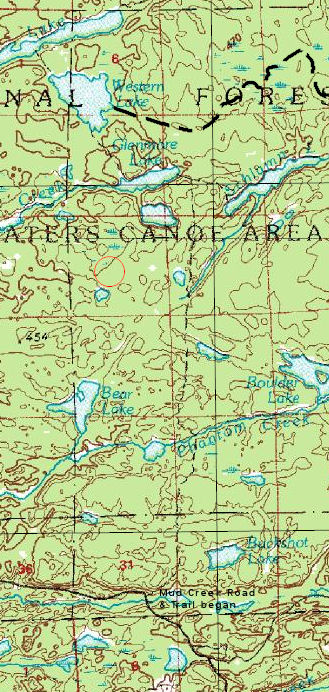
(Located within the red circle.)
Cummings Lake lies just to the north. (Again I apologize for not having the dates of these maps at my fingertips. I am downloading them using a program called ExpertGPS. All my paper copies are packed away for a major remodeling project at my house. The trail (dotted line at the bottom) comes from the Wolf Lake Road (and also the portage from Hassle Lake.

|
12/26/2007 09:20PM |
The road that passes by Tamarack lake is the old road that continues for miles.
You can also take the Clark Lake road off to the right just after Burntside, cross Tamarack Creek, and go to Clark Lake.
Just before Clark Lake, the road has a turn to the left that will take you to Battle and Phantom, also a few other lakes, then re-join the Wolf Lake road just before the old logging camp where the gate used to be (40 years ago)
There is an old 55 chevy in the woods where the camp used to be, and a few other odds and ends.
|
12/27/2007 08:45AM |
You make this more and more complicated. Another way in and a 1955 Chevy. My first car (purchased just as I went to college) was that vintage. I remember shortly after purchasing it the transmission went and I had to scrape together the $45 to pay the repair bill.
So I may have to reroute my brother to visit the chevy?
My brother and I gathered for Christmas and we were planning the purchase of the new gear we'd need (decent frame hiking packs). My wife said you better buy a new one,"I tossed out the decrepit one you had."
I will post a report on the trip and pictures when we return.
Keep talking about the 'high lights' and 'must see' stops we should include on the itinerary!
|
12/25/2007 07:56PM |
|
12/25/2007 10:38PM |
You seem to like the Crab area.
Crab portage was once a road, which the owner of a resort on Crab would drive his Duck across. (a duck was an amphibious vehicle)
Too much to elaborate in a forum.
If you ever get to Ely, stop in the shop and we'll talk.
Many logging camps in that area.
See if you can hunt down any 1958 Fisher maps, as they show all the old roads and locations of cabins.
When updates went on the maps, the roads and cabins went away.
|
12/27/2007 10:04PM |
Call the shop tomorrow morning, and I can describe the location.
If that doesn't work, let me know when you will be in Ely, bring your maps, and we'll take it from there.
All maps should be either the Fisher maps printed in 1958 or as late as 1970, maybe. They will show you locations of cabins and logging camps.
If you can transfer these to GPS maps, they should put you right on top of everything.
These should also show you the State Cabin we talked about last time you called.
|
12/20/2007 10:47AM |
Each Spring (end of April to first week of May), my dog Lila and I take a 2 to 3 day hike in or around the BWCA. I love this time of year in the North Woods. This year I have engaged the interest of a brother (along with Lila) to bushwhack from the end of the Wolf Lake Road (Tamarack Lake) to Western Lake.
I planto follow the old logging roads (from the Portal Zone days - 30 years ago). These old road beds should keep me on high ground for the most part and avoid the numerous bogs, sloughs, swamps (aka know as 'wetlands'). Traces of these road are still visible on recent - I think - satellite photos. A rough track suggest the hike would be 15 to 20 miles. In the 1970's I hiked many of these road to the East and West of Western Lake on my Spring Hike.
The goal of this hike? To get there.
Western lake has a strong pull for my brother and I. We made many trips in for walleye fishing in the 1970 and early 80' (from Crab to Cummings across the 1 miler to Buck and thence Western.)I had the best walleye fishing of my life on Western Lake.
I would like to hear whatever information people might have about the 'state of the bush' east and south of Western Lake.
Please try to restrain your replies to condition of the woods and not to the state of my sanity! ;>)
|
12/20/2007 11:02AM |
|
12/20/2007 03:28PM |
|
12/20/2007 03:49PM |
|
01/25/2008 07:15PM |
Burntside lake has been open 3 times by April 15th.
If it had stayed warm last spring, it would have been open by the 10th, maybe earlier.
|
12/26/2007 11:27AM |
|
12/26/2007 05:33PM |
|
10/02/2018 06:54PM |