|
10/02/2011 07:34AM |
|
10/13/2011 04:57PM |
I had lots of cramps that night. KF gave me the rest of his water that evening and I must have drank a cup full before going to bed but that did not do the trick. I drank near 3 quarts after noon that day. One quart on the last lake we were on and I started off carrying ½ gallon. I have been told the problem may have been that I may have been low on salt.
About 7 years ago I did the trip up the East side of the park to the Wawiak . The first night was on Saganagons and the next on Mack. The only portage that was a challenge was the one into Mack. The problem is the last 100 Yd’s is on a floating mud bog in the woods. There is a way to get around the mud. If you look at a map of Mack and find the most south place on the lake is a little tale extending South West from a round body of water. When you get to the bottom of the last hill you will be about 50 yards East of the tip of that tail. If you turn left at the bottom of the hill you will be headed for the tail. There was a path that meets the tail about ½ way between the ends of the tail. It was a poor landing with brush in the way to load the canoe but better than the mud slog. There were 4 log jams on the Wawiag.
May be by next year we can use the North entrance to the Wawiag.
MagicPaddler
|
11/14/2011 06:05PM |
With a southern breeze, you could be on Mack on day 2 from PP.
|
11/15/2011 03:26PM |
We went up Agnes-Kawnipi-Mack and back through the Falls chain-Saganagons-Man chain.
|
11/15/2011 03:34PM |
|
01/03/2013 07:34AM |
|
01/03/2013 04:28PM |
I bushwhacked from Belaire to the Wawiag in 2011 and did not get my feet wet. I sent my GPS tracks to Robin Reilly but that was shortly before he moved on. There is a bushwhack that is easier than the portage. Don’t get lost!!
|
01/03/2013 05:02PM |
quote MagicPaddler: "Stumpy that looks like a fun trip. That looks like your aluminum tank in the picture.
I bushwhacked from Belaire to the Wawiag in 2011 and did not get my feet wet. I sent my GPS tracks to Robin Reilly but that was shortly before he moved on. There is a bushwhack that is easier than the portage. Don’t get lost!!
"
Yes that's my grumman & that's me in the distance, getting the food pack through the swamp.
I read the last few parts of your trip report, the other night & loved it.
See you at wing night!
|
09/30/2011 10:59AM |
|
01/03/2013 10:43PM |
quote Bushwacker: "The creek from Belaire to the Wawiag is not passable. Here's a trip report describing the full portage from the Wawiag to McKenzie. Belaire to McKenzie is a nice single track albeit long, around 3/4 mile or so.
Belaire portage
"
Thanks, very helpful.
By the way, the "spirit" on the MacKenzie picto is Migizi - the Bald Eagle. There is a book one can purchase that has images and descriptions of Quetico pictos, and that is in there.
|
10/04/2011 01:30PM |
Do you have a link to your trip report or is it only available through BWJ by prchase of some sort? I'd like to read that!
|
10/05/2011 07:58AM |
|
11/15/2011 06:25AM |
|
12/09/2018 04:26PM |
This is a standby route I want to do if my paddling partner bails on me...
Kawnipi
McKenzie
Long portage to Belaire, not bad
169 rod portage Belaire to the Wawiag. Has a bog in the middle of it.
Wawiag to Mack Creek, Mack creek is passable?
Mack Creek to Mack Lake
Mack Lake to Munro
unnamed creek from Munro to Kenny
Then to McEwen and out...
thanks,
Joe
|
09/30/2011 12:03PM |
I lifted this from somebody who was in there in 5-2010, "The Wawiag was very pretty at the junction of the Mack Creek and then got narrower but was a nice paddle. Two log jams and one rapids. We portaged the rapids and one log jam and picked our way through the other log jam. A very enjoyable day. Somewhat tought but just part of the adventure. Isn't that why you go to the Q?"
From the Quetico 100 Stewardship website:
June 21, 2011, Re: Mack Lake Access
Quetico Park staff were recently working in the Wawiag River, Greenwood Creek, Mack Lake area doing maintenance, planning and enforcement. The staff explored options for access to the Wawiag River from the adjacent forestry road. They have identified a suitable route for a portage-based access point from the road. We will shortly begin planning and preparation for this portage and hope to begin to develop it this fall for use next season. The staff also travelled up the Greenwood Creek to Mack Lake, clearing downed trees along the way. This route is now easily passable. For this reason there is presently no reason to land aircraft on Mack Lake. In order to access Mack Lake please use the option of landing on either Clay or Ross Lake and use the associated portages. Should water levels drop significantly over the next month the Greenwood Creek access may become inadequate and I will notify you of aircraft landing options.
Robin ReillySuperintendent, Quetico Provincial Park.
|
09/30/2011 05:45PM |
I went from Belaire to the logging road Robin Reilly is speaking of. I sent him my GPS tracks. I am waiting to see if they found my tracks the best way in.
River1 River2
|
12/11/2018 05:43PM |
Joe
|
10/02/2011 04:43PM |
MagicPaddler
|
12/10/2018 10:19AM |
|
12/10/2018 10:06PM |

But when we tried to go from Mack Lake to the Wawiag in the first week of September we easily paddled to the first dam, but below the dam we could only paddle a hundred yards or so before the water became too shallow to continue. We attempted to bushwhack to the Wawiag, but it was just too time consuming and difficult to follow a moose path near the creek. We ended up having to turn around and go back.


|
10/03/2011 05:53AM |
|
11/18/2011 07:47PM |
|
10/10/2018 10:10AM |
Just joined the chat page. I few years ago I went from Clay to the Wawaig River found the Totem marker and portaged to Belair lake on to Makenzie and back out. A great trip. Sorry I am so late with this info.
Jbarth
|
10/09/2011 03:28PM |
I'm seriously thinking of going north through Mack into the Wawiag for my next Q adventure. Just can't afford to do the fly in these days.
|
11/18/2011 02:09PM |
The fall of 2007 was the first time I made that paddle. I encountered a set of rapids that had to be portaged around about 3 miles from Mack Creek. The portage also is a campsite that can easily fit two, maybe three, tents.
Between the rapids and Kawa Bay I came upon three logjams, one of which I had to portage around and the other two I was able to barely squeeze through an opening in the logs.
In the spring of 2009 I had to portage around all three of the logjams.
The Cache Bay ranger Janice told me that in the summer of 2010 there was an odd day in which the water level of the Wawiag changed a couple of feet within 24 hours and all three logjams were broken up.
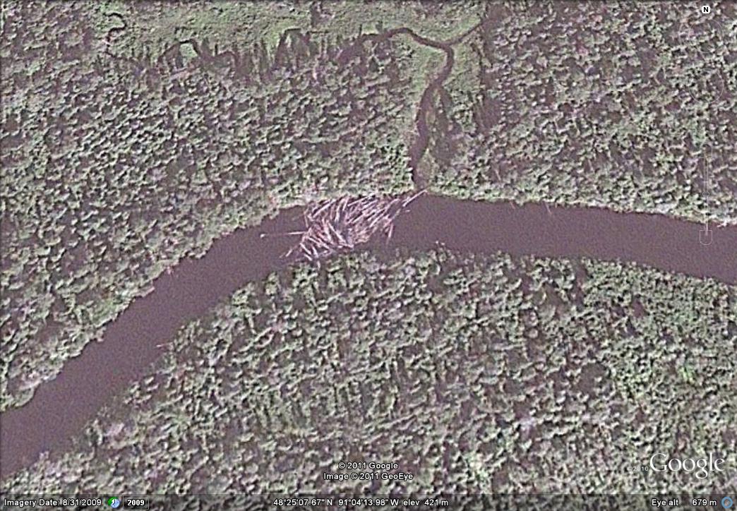
I paddled the river in both the spring and fall of 2011 and found that Janice had not been telling me stories as all three logjams had cleared out. One of my paddling partners made the observation that those areas now look like a graveyard of logs as most of the logs are hugging the banks of the river.
I thought these logjams were quite large and I find it amazing that the water level changing dramatically in a short time would have enough power to break them up. The following is a Google Earth picture of one of logjams in 2009. In order to give you some perspective, the river is 75 feet wide in this photo.
|
01/02/2013 10:16PM |
quote MagicPaddler: "DWT
You should read my solo trip report where I bushwhacked from Belair to the Wawiag to the logging road and back one day.
Report thread "
Excellent, thanks!
But honestly, I cannot tell if you actually did the creek that connects Bellaire to the Wawiag - it seems like you are saying you trucked around it, and then went south to the Wawiag. Is that true?
And how was the MacKenzie-Bellaire Portage?
|
01/02/2013 03:31PM |
I've always been intrigued with hitting the Wawiag River, Bellaire Lake, and Mackenzie. If you put in at Clay Lake, you could almost make a loop via the Wawiag, Kawa Bay, around to MacKenzie, up MacKenzie, portage to Bellaire, creek to Wawiag, then back to the Greenwood Creek and Mack.
Or, even more ambitious (or perhaps insane), Wawiag to Bellaire to MacKenzie to Ferguson to Cache River, then out of the park north from where Cache River empties out. I'm not even sure the Bellaire-MacKenzie portage really exists, it is only present on some maps.
Any word on the road to the Wawiag, since late in 2011?
Can the Wawiag be done upstream, reasonably?
Anyone ever hit the Bellaire portage?
And finally... instead of using a road (you can see the logging roads on a map) to get to the Wawiag, what about following Tilly Creek from up near Hwy 11? It seems to flow down into the Wawiag, unless I am missing something. I wonder if it is navigable.
|
01/02/2013 04:56PM |
You should read my solo trip report where I bushwhacked from Belair to the Wawiag to the logging road and back one day.
Report thread
|
01/03/2013 10:43AM |
Belaire portage
|
10/11/2018 11:31AM |
Jbarth
|
10/13/2011 05:50PM |
quote MagicPaddler: "I do not think Robin will reply to you so I will give you what I believe is the situation. These are not public roads. They belong to the company that built them or the Forestry Services. Robin must get permission to use them. He and my outfitter together were able to get permission for a one time use a few years ago for Kingfisher and me to do a exploratory trip. King fisher wrote an article in the BWJ about our adventure. At that time there was a washout a little over 3 miles from where you would get to the Wawiag. We carried about 1 mile down the road then took a bushwhack through to McKenzie. A rout I do not think you want to follow. If you could get past the washout you could drive within 1 mile of the Wawiag and it is a easy walk the rest of the way.
MagicPaddler
"
Couple more questions.
Are these roads gated or posted or what?
Have you ever fished or have any info on the cluster of lakes just north of Bemar; Elevation, Need, Little Falls and Twinhouse lakes? I know Elevation has good lake trout fishing and can be accessed via portage from Bemar and thay all have portage links. I can see some type of logging road running by the north end of Elevation on google maps. I was right there one time but couldn't get anyone in my group to go up to Elevation and I've been kicking myself ever since for not doing it.
|
10/11/2018 01:00PM |
jbarth: "I was reading your trip to Belair Lake. Which way did you travel to get there ?Jbarth
Jbarth"
If you are referring to my trip in 2011 I came from McKenzie Bay to McKenzie to Belaire.
|
10/14/2011 06:40PM |
I have never been in the lakes you mentioned except for Bemar but I have been on both sides of them. I have been on Mowe. When I portaged into that lake I found a local car camping at the edge of the logging road on the south side. One time I took the creek out of the north end of Trafaigar Bay North and then East to a little unnamed lake. As we paddled out on to the lake a motor boat went speeding by. So much for solitude. We did see a moose on the return trip down the creek. My point is if there is a logging road near the lake the locals will take advantage of it so check out google earth and do one portage past the lake near the logging road.
Looking at the logging road north of Elevation I would guess that road is not passable with a car or truck. Let us know if you get there.
MagicPaddler
|
10/01/2011 05:47PM |
You start out flying into Clay Lake with 1 or 2 canoes strapped on 1 pontoon of the float plane. The Canadian flight service ( usually out of Lac La Croix) requires nesting a shorter 17 1/2 or 18 foot canoe into a slightly larger 18 - 18 1/2 footer on 1 pontoon. When you land on Clay... you go to the shoreline and unnest the canoes and attach the thwarts to both canoes.
Additionally, I have found that outfitters require that you rent the one or 2 canoes for a fly-in. When I have inquired as to why ? ... they have always told me for liablity reasons. Apparently, there have been times when flight personnel over tighten the straps when cinching down the canoes to the pontoon and canoes have sustained damage. I would certainly like to bring my own Minnesota II. This canoe rental requirement and increasingly higher fly-in rates has made a fly-in trip very cost prohbitive. I think the fly-in cost 1 way is up to around $450 - $500 or more 1 way per person.
That is unfortunate as a fly-in trip affords you a way to get from Clay to Kawa Bay in 1 day. In fact, I have made it to McKenzie Bay in 1 day but you really have to be pushing yourself to do that. You can take a bit more food on on the fly-in as you only have about 5 portages depending on log jams and beaver dams.
The water on the Greenwood River can get low after the 4th of July and I have heard that when that happens, that sometimes flights are allowed to land on Mack Lake. Back in the early 1980's I once had to drag a canoe almost 4 miles with my brother in law on the very shallow Greenwood Creek to get to the deeper Waiwag River when abnormally low water levels didn't allow us to paddle.
The Waiwag River to Kawa is a very nice paddle. There is usually a lot of wildlife and there is a descent chance to see a moose as you peek into large hidden bays that are dotted along the Waiwag.
I have not seen any campsites along the Greenwood or Waiwag Rivers so you will have to start early to get to Kawa Bay before dark for a campsite.
I think everyone ought to experience at least 1 fly-in trip into Quetico.
|
10/11/2018 06:41AM |
Here is a report.
Bushwhack to the Wawiag
|
01/03/2013 11:22AM |

This is part of the portage from Wawiag to Belaire.