BWCA Entry Point, Route, and Trip Report Blog
June 05 2025
Entry Point 77 - South Hegman Lake

Number of Permits per Day: 1.5 (varies by day)
Elevation: 1282 feet
Latitude: 48.0336
Longitude: -91.9250
South Hegman Lake - 77
Can we do a more difficult loop?
Entry Date:
May 30, 2025
Entry Point:
South Hegman Lake
Number of Days:
3
Group Size:
2
We dropped off a vehicle at Mudro and headed over to South Hegman. We were on the water shortly after 9:00. We settled in nicely and moved along up to the Picto's on North Hegman. 
 From there we continued on to the Trease to Angleworm Portage. Now, I've done the Horse Portage, Gun Portage, Muskeg to Kiskidinna, Tuscarora to Missing Link, Seagull to JAP and a few others that consistantly make the worst portages in the BW list. A quick rating...1. Seagull to JAP; 2. Trease to Angleworm 3. Tuscarora to Missing LInk (in that direction).
The portage was longer than advertised, the swamp is hard to pick your way through. There's easily a dozen options of people trying to find higher ground or less mud...good luck, if you miss stepping on a log or grass patch, your calf to knee deep in muck. We arrived at Angleworm, put on some bug dope and had a quick lunch. We paddled straight into a strong headwind up Angleworm and made our wat to Gun Lake by 5:00. The 271 portage into Gull was a breeze. Every portage, even those around a mile in length felt easy for the rest of the trip. We camped on Gun Lake, site 1083. This is a 5 star site in my opinion. One of the best i've come across. 
We awoke to a gorgeous morning on Gun Lake.  Plan for today was to head up to Crooked and paddle until we've had enough. After some cakes for breakfast and a quick pack up, we were on the water around 9:00. I forget which portage between Gun and Crooked, but we came across the always beautiful Lady Slipper.
  We made it to Crooked and as is usually the case for all canoe trips, we were paddling straight into the wind. We stopped at site 1869 for some lunch, took a swim to cool off and clean up a bit. This site is elevated doesn't have much for tent pads and the fire grate is oddly placed off to the side. It's best feature would be the 4ish or so high rock where you can jump into the lake. It's plenty deep right off the site.
  From there we made our way up the bay hung a right and headed towards the falls. There was a surprising amount of current. In spots where the lake narrowed, it was full throttle with the solo and single blade to keep it moving forward. The current was easily visable and lots of little swirls and whirpools. If you got turned sideways at all in the more narrow points you would just be swept back down. We paddled until around 5:00 and settled into site 1859.
 This site had decent tent pads, but it was hard to get comfortable using some of them as a number of them had widowmakers leaning over them. This site also gave me the creeps a bit. Yep I said it. It gave me the creeps. Let me expand: This was my 41st overall BW trip and in addition to that i've spent countless hours and countless other nights in the SNF. In 26 years of spending ALOT of time in the woods, I can count on one had the times I've got the "creeps". In this case, we kept hearing this odd, louder than you'd expect sound back in the woods behind camp. It sounded like either a big stick getting snapped in half or rocks clanking together. After hearing a few times and kind of around sunset, we wandered back into the woods to investigate. We came across an area where the were some large swan feathers laying around and at one point, my son and I were maybe 30 feet apart standing still and listning when we heard the loud cracking sound right between us, with no apparant cause of the sound. We walked back to camp and had a kind of uneasy nights sleep, being woken multiple times by various strange sounds. It was just weird. I had something very similar happen many years ago on Kekekabic...just unusual clanking/cracking sounds that just kind of seemed out of place.
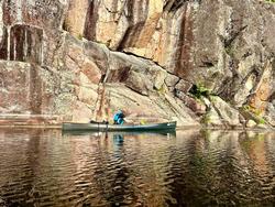
After a kind of restless night, we awoke had some snacks and hit the water a little before 8:00. We stopped to check out the Pictos on Crooked. 


 From there we made our way to Lower Basswood falls. It was roaring. The Forest Service was set up in camp 1548 as a base camp for fighting the Horse River Fire. When we eventually made our way into the Horse River we could hear chainsaws, from what I assume were cutting containment lines.
  Onwards to the Horse River. In all my years in the BW and trips up to Crooked, I've never been on the Horse River. As a former kayak racer, I always preferred paddling and we'd just jump on Basswood and fly up. In this case, to make what I felt like was the more difficult route, we chose the Horse River. Now I tell you that to tell you this...there are a number of rapids on the Horse, some marked on maps, some not. I don't know if they're paddlable under higher water or not. I also don't know if there are portages around these unmarked rapids or not. We came to them and they were a surprise and we opted to just wade and push/pull the canoe through.
 Horse lake was uneventful, other than more wind. It's a phenomenon that should really be studied - how it's possible that 90 plus percent of the time you'll be paddling into the wind in the BW. You can switch directions 4 times in a day and be paddling into the wind every time. Someone needs to study this.
The lakes between Horse and Mudro went by rather quickly and we exited. Stopped by the boathouse for a beer and burger, well for me, water and burger for my kid. Absolutely fantastic trip - I loved every minute of it.