WCPP top to bottom
by hobbydog
Trip Type:
Paddling Canoe
Entry Date:
06/15/2015
Entry Point:
Other
Exit Point:
Other
Number of Days:
14
Group Size:
1
Discuss Trip:
View Discussion Thread (26 messages)
Day 12 of 14
Friday, June 26, 2015
22 Miles 7 portages, 700 meters
I was on the water early. It was going to be another warm day and Talon Lake was smooth and quiet. It did not take long to make it across the lake. I had no idea what to expect going out the Talon River entry point. I assumed it was not a well-traveled route. The 4 portages were easy and clear, mostly downhill. The Talon River is shallow grassy with a light current. In 11 days I have gone from top to bottom. Some long days and some short days…no layover days. Still no wind or clouds and Eagle Lake is calm. It is the largest lake I have to cross so not having to deal with the wind is nice. I take a break at a campsite across from the Bird River entry point and have some lunch. My water filter is getting hard to pump so I am dipping out of the lake today. I was going to lay up on Eagle Lake but decide to keep going as long as I had good paddling. As I round the corner onto the main lake I met a couple boats from the fly-in outpost on Eagle. They wave and take some pictures of me as they pass by. I must have enhanced their wilderness experience. ? It seems like in no time I am across Eagle and into Midway Lake. As you leave Midway you go through a channel into Chase Lake there is an outpost cabin. There are a couple guys there so I stop to talk. They were from the twin cities area so we have a nice chat. They offered me an ice cold diet coke and a salted nut roll. I couldn’t refuse. It had been awhile since I had talked to anyone so this was a nice break. There is a breeze starting to blow so I get going across Chase Lake and into the Bird River. There is a short portage and a boat cache on the other side. It is getting into the afternoon so I start thinking about a place to camp. I come across a cow moose feeding in the river. I am able to paddle up close every time she goes under to eat. I enjoy watching her for awhile. Soon I am at a portage that has a falls on each side. You portage down the middle of the island. An old trip report I found says this is a nice place to camp. I am able to find the portage but it hasn’t been used since the blowdown. It is short, maybe 80 meters. I clear it out but there is not much place to set up a tent. I was planning on doing this set of portages in the morning but as long as the going is easy I decide to keep going. The next portage is only a few hundred meters away. The portage landing is easy to get to on the north side but there is no trail to be found. It is another short one….100 meters or so and I bushwack across it. Not too bad. Another couple hundred meters to the next portage. This is the one I made it to on my 2012 trip but couldn’t find my way across. I know there is a campsite on the other side but I find an ok place by the landing. Small but it will do. It has been a long day. I get camp set up and then decide to scout the portage. I have some good Bing aerial photos and my GPS. I am able to bushwhack through without too much difficulty if I break it up into two pieces. I will be able to sleep better knowing what lies ahead in the morning. This was my longest day of the trip, I am pretty tired out but feel good about getting across the big water and knowing tomorrow is going to be an easy day. As I am eating my supper a cow moose walks out in front of me and joins me for supper. A nice way to end the day.
Talon Lake Sunrise
Talon River below from the portage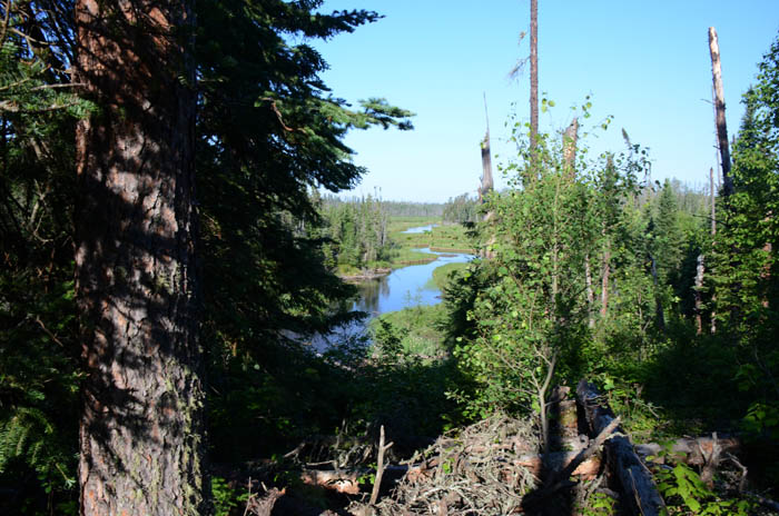
Talon Lake Entry Point Sign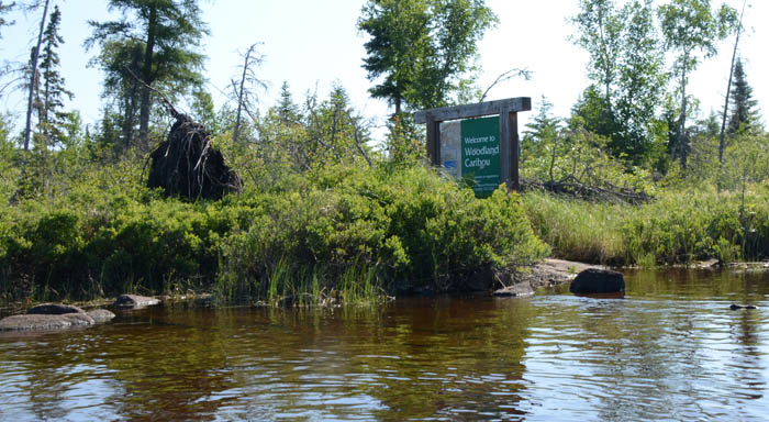
Island Portage on the Bird River
Bird River Moose
Joining me for supper

Leaving WCPP
22 Miles 7 portages, 700 meters
I was on the water early. It was going to be another warm day and Talon Lake was smooth and quiet. It did not take long to make it across the lake. I had no idea what to expect going out the Talon River entry point. I assumed it was not a well-traveled route. The 4 portages were easy and clear, mostly downhill. The Talon River is shallow grassy with a light current. In 11 days I have gone from top to bottom. Some long days and some short days…no layover days. Still no wind or clouds and Eagle Lake is calm. It is the largest lake I have to cross so not having to deal with the wind is nice. I take a break at a campsite across from the Bird River entry point and have some lunch. My water filter is getting hard to pump so I am dipping out of the lake today. I was going to lay up on Eagle Lake but decide to keep going as long as I had good paddling. As I round the corner onto the main lake I met a couple boats from the fly-in outpost on Eagle. They wave and take some pictures of me as they pass by. I must have enhanced their wilderness experience. ? It seems like in no time I am across Eagle and into Midway Lake. As you leave Midway you go through a channel into Chase Lake there is an outpost cabin. There are a couple guys there so I stop to talk. They were from the twin cities area so we have a nice chat. They offered me an ice cold diet coke and a salted nut roll. I couldn’t refuse. It had been awhile since I had talked to anyone so this was a nice break. There is a breeze starting to blow so I get going across Chase Lake and into the Bird River. There is a short portage and a boat cache on the other side. It is getting into the afternoon so I start thinking about a place to camp. I come across a cow moose feeding in the river. I am able to paddle up close every time she goes under to eat. I enjoy watching her for awhile. Soon I am at a portage that has a falls on each side. You portage down the middle of the island. An old trip report I found says this is a nice place to camp. I am able to find the portage but it hasn’t been used since the blowdown. It is short, maybe 80 meters. I clear it out but there is not much place to set up a tent. I was planning on doing this set of portages in the morning but as long as the going is easy I decide to keep going. The next portage is only a few hundred meters away. The portage landing is easy to get to on the north side but there is no trail to be found. It is another short one….100 meters or so and I bushwack across it. Not too bad. Another couple hundred meters to the next portage. This is the one I made it to on my 2012 trip but couldn’t find my way across. I know there is a campsite on the other side but I find an ok place by the landing. Small but it will do. It has been a long day. I get camp set up and then decide to scout the portage. I have some good Bing aerial photos and my GPS. I am able to bushwhack through without too much difficulty if I break it up into two pieces. I will be able to sleep better knowing what lies ahead in the morning. This was my longest day of the trip, I am pretty tired out but feel good about getting across the big water and knowing tomorrow is going to be an easy day. As I am eating my supper a cow moose walks out in front of me and joins me for supper. A nice way to end the day.
Talon Lake Sunrise
Talon River below from the portage
Talon Lake Entry Point Sign
Island Portage on the Bird River
Bird River Moose
Joining me for supper
 Donate - BWCA.com