BWCA Entry Point, Route, and Trip Report Blog
September 23 2025
Entry Point 4 - Crab Lake & Cummings Lake

Crab Lake and Cummings from Burntside Lake entry point allows overnight paddle only. This entry point is supported by Kawishiwi Ranger Station near the city of Ely, MN. The distance from ranger station to entry point is 23 miles. Access from Burntside Lake with a 320-rod portage to Crab Lake. This area was affected by blowdown in 1999.
Number of Permits per Day: 3
Elevation: 1406 feet
Latitude: 47.9337
Longitude: -92.0269
Crab Lake & Cummings Lake - 4
Number of Permits per Day: 3
Elevation: 1406 feet
Latitude: 47.9337
Longitude: -92.0269
Crab Lake & Cummings Lake - 4
Southern Reaches of Little Indian Sioux
by prettypaddle
Trip Report
Entry Date:
July 14, 2008
Entry Point:
Little Indian Sioux River (south)
Exit Point:
Trout Lake (1)
Number of Days:
4
Group Size:
2
Trip Introduction:
With Eric finishing his thesis and both of us preparing to move to Chicago in November, we had thought a trip to the Boundary Waters would be out of the question this year. Then May rolled around and we decided to go for it. It would have to be a short trip to allow time for visiting with Eric's family during our week in Ely, so we broke out the maps and checked the permit availability. There it was, calling to us--the Little Indian Sioux South entry point. With a quota of one permit every other day and the whole month of July wide open, we were sold. Four days seemed perfect for exploring this little orphaned piece of the Boundary Waters.
Part 1 of 9
Saturday, July 12, 2008 [paragraph break] On a plane bound for Minneapolis there is, as one pilot put it, a "sporting breeze" which makes the landing exciting to say the least. Eric--supposedly connecting through Detroit--gives me quite the shock by walking onto my flight to Duluth. Due to weather he was re-routed and by some strange coincidence ended up in the seat next to me. What a wonderfully surreal way to begin the trip. [paragraph break] Another wild flight lands us in Duluth where we're met by his folks for the drive up to Ely. The lakes we pass are rolling with white caps. When we arrive at the house on White Iron, we're informed by his visiting sister's family that a couple of poplars have blown down. These will not be the last downed trees we encounter.
Part 2 of 9
Sunday, July 13, 2008 [paragraph break] Packing day. We pick up our permit at the new ranger station and Ranger Tom assures us the water is about three feet above normal right now--good news for a trip on tiny rivers. [paragraph break] In town we buy three new Fisher maps (we want to make sure we're covered since we have several contingency plans). Three brand-new maps equals an entire trip of brand-new territory for both of us. We get some groceries at Zup's and then it's back to the house to assemble our gear. [paragraph break] Eric, bless his heart, is much more likely to wander away to play with his niece and nephews or to sit in the midst of the chaos tinkering with some gadget than to actually put anything in a bag. He takes a moment to show off his pirate headgear. [paragraph break]  [paragraph break] We lay out the maps and show Eric's folks the rough plans: Plan 1--Little Indian Sioux all the way to Cummings and exit Crab to Burntside. Plan 2--LIS to Trout, then make our way through Chad and Buck to Cummings or Lunnetta and exit through Burntside. Plan 3--LIS to Trout and exit Vermillion.
His dad thinks we're crazy but his mom knows we want adventure.
[paragraph break] We lay out the maps and show Eric's folks the rough plans: Plan 1--Little Indian Sioux all the way to Cummings and exit Crab to Burntside. Plan 2--LIS to Trout, then make our way through Chad and Buck to Cummings or Lunnetta and exit through Burntside. Plan 3--LIS to Trout and exit Vermillion.His dad thinks we're crazy but his mom knows we want adventure.
Part 3 of 9
Monday, July 14, 2008 [paragraph break] Day 1--Little Indian Sioux River--Little Pony River--Bootleg Lake [paragraph break] After two days of cool weather and rain, we begin the trip with a bright blue sky and mild temperatures. The river is postcard-perfect. And also quite wide which relieves some of my anxieties about our proposed route. The river dwindles to a single line on the map so a narrow river at the put-in (where the river is depicted as quite wide on the map) would have meant it was impossibly small farther south. We wave goodbye to his parents and start to wind our way up the river. [paragraph break] A couple of miles in there's a sign marking our entry into the Boundary Waters. Shortly after that we investigate some yellow squares nailed to trees and discover a section marker. Township 65, Range 15, between Sections 13 and 14. [paragraph break] 

 [paragraph break] With the water so high we figure we might be able to paddle through the first portage. Not quite. Sioux Falls is a very impressive little water fall. Its water has carved out a pool free of grass and ringed by foam. A short carry, a little beaver dam (the first of many), and we're paddling through monster hair. Waving in the current the stuff looks seriously like the hair on the back of some great beast. It's mesmerizing to watch. [paragraph break]

 [paragraph break] We're able to find the Pony River easily enough (we had worried) and it wasn't as tiny as we had feared. With clouds piling up we get out the rain gear and have lunch on the river. Have I mentioned the bugs? The mosquito hoards make time on shore into a windmilling, swatting dance (when we can actually find solid ground to get out on that is). We're traveling on a tiny river surrounded by swamps. Maybe we really are crazy. [paragraph break] A light shower puts an end to lunch and we continue on the ever narrower river. The beavers have been busy. With the high water we're able to paddle over most of the dams. Until we reach the granddaddy of all beaver dams--the Boover Dam. This busy beaver had made himself quite the little pond; no wonder since a good two-and-a-half feet of dam sticks up above the water. It takes some doing, but we're still able to just lift the canoe over. More winding river, a couple of pretty short portages and we're at Bootleg Lake. We choose the southernmost campsite and, with the skies threatening, quickly set up camp. [paragraph break]

 [paragraph break] We wait out a passing shower in the tent. When the sky clears we take a quick dip and start a fire for dinner. Thunder rumbles in the distance. A light rain starts up. I urge Eric to eat more quickly so we can do the dishes, hang the bear bag and hide in the tent. The storm is on top of us now. Wind, rain, lightening. We--ok, I--cower. Eric very reassuringly points out that the tent is far enough from the trees that they won't blow down on top of us but close enough that we're not the highest point around. Ok, we can do this. It's just a little rain. And wind. And lightening. [paragraph break] Huddled in the tent we watch the storm. Before my eyes the far end of the lake is blotted out by grey. It was there, and then it simply wasn't. The nothingness eats away at our lake and, as fast as I can point it out with wild shouts, hail is pounding down around us. Inside the grey curtain we can see the lake again and it's boiling with hail. [paragraph break] [paragraph break] Being a good Midwestern girl, I know that hail presages Bad Things. Having lived in California for the past six years, and having seen nothing more sinister than a thick fog, I am Scared. We have a Nylon Tent for protection. We are in the Middle of Nowhere. We have seen No One all day long. What if a tree falls on us? What if we're struck by lightening? What if a tornado tears through camp? [paragraph break] Eric may not be much of a help when it comes to packing, but he sure is a comfort (and a good man-shield) in a hail storm. And all my fears were unfounded: the hail passed, the sun came out and a double rainbow arched from one end of our lake to the other. We survived! [paragraph break]

 [paragraph break] Another storm rolls through in the night. Lightening very effectively illuminates the inside of a nylon tent. Too exhausted to worry about another storm, we both roll over and go back to sleep. [paragraph break]
[paragraph break] With the water so high we figure we might be able to paddle through the first portage. Not quite. Sioux Falls is a very impressive little water fall. Its water has carved out a pool free of grass and ringed by foam. A short carry, a little beaver dam (the first of many), and we're paddling through monster hair. Waving in the current the stuff looks seriously like the hair on the back of some great beast. It's mesmerizing to watch. [paragraph break] [paragraph break] We're able to find the Pony River easily enough (we had worried) and it wasn't as tiny as we had feared. With clouds piling up we get out the rain gear and have lunch on the river. Have I mentioned the bugs? The mosquito hoards make time on shore into a windmilling, swatting dance (when we can actually find solid ground to get out on that is). We're traveling on a tiny river surrounded by swamps. Maybe we really are crazy. [paragraph break] A light shower puts an end to lunch and we continue on the ever narrower river. The beavers have been busy. With the high water we're able to paddle over most of the dams. Until we reach the granddaddy of all beaver dams--the Boover Dam. This busy beaver had made himself quite the little pond; no wonder since a good two-and-a-half feet of dam sticks up above the water. It takes some doing, but we're still able to just lift the canoe over. More winding river, a couple of pretty short portages and we're at Bootleg Lake. We choose the southernmost campsite and, with the skies threatening, quickly set up camp. [paragraph break] [paragraph break] We wait out a passing shower in the tent. When the sky clears we take a quick dip and start a fire for dinner. Thunder rumbles in the distance. A light rain starts up. I urge Eric to eat more quickly so we can do the dishes, hang the bear bag and hide in the tent. The storm is on top of us now. Wind, rain, lightening. We--ok, I--cower. Eric very reassuringly points out that the tent is far enough from the trees that they won't blow down on top of us but close enough that we're not the highest point around. Ok, we can do this. It's just a little rain. And wind. And lightening. [paragraph break] Huddled in the tent we watch the storm. Before my eyes the far end of the lake is blotted out by grey. It was there, and then it simply wasn't. The nothingness eats away at our lake and, as fast as I can point it out with wild shouts, hail is pounding down around us. Inside the grey curtain we can see the lake again and it's boiling with hail. [paragraph break] [paragraph break] Being a good Midwestern girl, I know that hail presages Bad Things. Having lived in California for the past six years, and having seen nothing more sinister than a thick fog, I am Scared. We have a Nylon Tent for protection. We are in the Middle of Nowhere. We have seen No One all day long. What if a tree falls on us? What if we're struck by lightening? What if a tornado tears through camp? [paragraph break] Eric may not be much of a help when it comes to packing, but he sure is a comfort (and a good man-shield) in a hail storm. And all my fears were unfounded: the hail passed, the sun came out and a double rainbow arched from one end of our lake to the other. We survived! [paragraph break] [paragraph break] Another storm rolls through in the night. Lightening very effectively illuminates the inside of a nylon tent. Too exhausted to worry about another storm, we both roll over and go back to sleep. [paragraph break]
Part 4 of 9
Tuesday, July 15, 2008 [paragraph break] Day 2--Bootleg Lake--Little Indian Sioux River--Little Trout Lake [paragraph break] Sunlight through the tent. Now that's a nice way to wake up after an eventful evening. The tent and tarp dry out while we eat breakfast and pack the rest of the gear. We decide, based on the shallowness of the Little Pony River, that we won't follow the length of the Little Indian Sioux upstream to Cummings. Even with enough water to float a canoe, it would be a long, curvy paddle to the first campsite. For now we'll head to Little Trout and see where we can get after that. [paragraph break] We're on the water pretty early, but make up for it by our inability to find the portage. As we nose into the fourth or fifth likely opening, a beaver plops into the water and slaps his tail at us. He probably knows we got past the Boover Dam and is saying, "Good luck, suckers! Wait 'til you see what I've been up to!" [paragraph break] 
 [paragraph break] We had checked out the new Voyageur maps while in Ely and read that "the long portages in the northeast corner of Map 3 receive infrequent maintenance and are quite challenging." They did their homework. In spite of the long-dead and newly-fallen trees which require amazing feats of agility to maneuver over, under, around, and through the snagging branches and enormous trunks (downed by vengeful beavers or recent winds), and aside from being pretty overgrown, the first 75 rods or so of the trail is fairly distinct. [paragraph break] Then the trees thin, bare rock protrudes, and a multitude of paths appear. Eric's gone ahead with the canoe and I struggle to find his trail. I try to tap into some dormant, primeval tracking skills that early man surely possessed. My ancestors obviously did not stalk the elusive canoe-carrying Minnesotan. Lacking skill, I go for the trial and error method instead. I start off in a couple of different directions before I spot a stone cairn marking the path. [paragraph break] We're trying out the portage-and-a-half method for the first time so I drop my gear in what I hope is an obvious place (bonus if it's actually the portage), and start back for the second load. Eric and I meet in the middle (miraculously finding the first load of gear) and he brings the joyous news that there is actually a river at the other end of the portage. There are no pictures of this 200-rod portage. We load up the canoe, have some mint chocolate cookies, and continue up the river. [paragraph break]
  [paragraph break] We put into practice our "river = overgrown lake" theory of navigation. Instead of tediously tracking each bend in the river, we just assume the trees are on islands in a grassy green lake. We paddle on and on. And on. River travel is very relaxing in a grassy, crooked sort of way. [paragraph break] Our theory begins to break down, or at least trees are beginning to grow in unexpected places. All the anxiety from the night before comes flooding back--we think the portage should be here somewhere, but how on earth are we going to find it when the "shore" is one big mass of undifferentiated swamp grass? [paragraph break] I see and dismiss from mind a log jutting out of the water--where is the portage? Is that it? No, that's another game trail. There? No, just another inlet. We paddle on until Eric says, "Huh. That log sticking out of the water had a sawn-off end. Let's go back and take a look." Ok, sure, why not? Maybe we've already paddled past the portage. [paragraph break]
  See that log just to the right of my shoulder? Now, see the portage? Yeah, we wouldn't have either without that log which turned out to be part of an old submerged dock. We shove back out onto the river (the bugs really are terrible this year) to have lunch before attempting the 376 rods. [paragraph break] Muck. Mud. The portage is pretty easy to find--just follow the mucky mud. And the downed trees. If you stray from the path, look for a downed tree. If you're sinking to your knees while looking at said downed tree, you're on the portage. After helping Eric shove the canoe through one particularly dense downed pine, I fall behind. The paddles and fishing pole are catching on everything and I probably should have changed out of my sandals for this one. Oh well. About a third of the way across, the muck gives out as the land begins to rise. We're doing the portage-and-a-half again so I drop the gear and head back through the muck to slog through it all over again with the food pack. [paragraph break]
  We finally make it to Little Trout and almost push the canoe right through a perfect little bird's nest. We paddle to the island to take a quick dip and rinse off the portage grime. While pulling off 10 or 15 ticks each, we discuss our options. The discussion goes something like this: "There's at least 510 rods of portaging before we get to Buck." "Looks like the clouds are piling up again." "Let's camp here." [paragraph break] Picking a site that looks breezy, we set up the tent and head out to try and catch dinner. This is the first year I didn't buy a license. I've finally made peace with the fact that I don't enjoy sitting in a canoe holding a fishing pole. I'm much more happy paddling Eric around while he trolls--I can let my mind wander and not have to jerk back to reality too late to catch whatever was nibbling at my untended line. [paragraph break]

 [paragraph break] It's pretty windy and Eric's not having much luck so we head back to camp and eat dinner while watching the clouds build. It starts to sprinkle so we scurry to all the chores then retreat to the tent to watch the sun go down. We are both asleep before it has completely set. [paragraph break]
[paragraph break] We had checked out the new Voyageur maps while in Ely and read that "the long portages in the northeast corner of Map 3 receive infrequent maintenance and are quite challenging." They did their homework. In spite of the long-dead and newly-fallen trees which require amazing feats of agility to maneuver over, under, around, and through the snagging branches and enormous trunks (downed by vengeful beavers or recent winds), and aside from being pretty overgrown, the first 75 rods or so of the trail is fairly distinct. [paragraph break] Then the trees thin, bare rock protrudes, and a multitude of paths appear. Eric's gone ahead with the canoe and I struggle to find his trail. I try to tap into some dormant, primeval tracking skills that early man surely possessed. My ancestors obviously did not stalk the elusive canoe-carrying Minnesotan. Lacking skill, I go for the trial and error method instead. I start off in a couple of different directions before I spot a stone cairn marking the path. [paragraph break] We're trying out the portage-and-a-half method for the first time so I drop my gear in what I hope is an obvious place (bonus if it's actually the portage), and start back for the second load. Eric and I meet in the middle (miraculously finding the first load of gear) and he brings the joyous news that there is actually a river at the other end of the portage. There are no pictures of this 200-rod portage. We load up the canoe, have some mint chocolate cookies, and continue up the river. [paragraph break] [paragraph break] We put into practice our "river = overgrown lake" theory of navigation. Instead of tediously tracking each bend in the river, we just assume the trees are on islands in a grassy green lake. We paddle on and on. And on. River travel is very relaxing in a grassy, crooked sort of way. [paragraph break] Our theory begins to break down, or at least trees are beginning to grow in unexpected places. All the anxiety from the night before comes flooding back--we think the portage should be here somewhere, but how on earth are we going to find it when the "shore" is one big mass of undifferentiated swamp grass? [paragraph break] I see and dismiss from mind a log jutting out of the water--where is the portage? Is that it? No, that's another game trail. There? No, just another inlet. We paddle on until Eric says, "Huh. That log sticking out of the water had a sawn-off end. Let's go back and take a look." Ok, sure, why not? Maybe we've already paddled past the portage. [paragraph break] See that log just to the right of my shoulder? Now, see the portage? Yeah, we wouldn't have either without that log which turned out to be part of an old submerged dock. We shove back out onto the river (the bugs really are terrible this year) to have lunch before attempting the 376 rods. [paragraph break] Muck. Mud. The portage is pretty easy to find--just follow the mucky mud. And the downed trees. If you stray from the path, look for a downed tree. If you're sinking to your knees while looking at said downed tree, you're on the portage. After helping Eric shove the canoe through one particularly dense downed pine, I fall behind. The paddles and fishing pole are catching on everything and I probably should have changed out of my sandals for this one. Oh well. About a third of the way across, the muck gives out as the land begins to rise. We're doing the portage-and-a-half again so I drop the gear and head back through the muck to slog through it all over again with the food pack. [paragraph break] We finally make it to Little Trout and almost push the canoe right through a perfect little bird's nest. We paddle to the island to take a quick dip and rinse off the portage grime. While pulling off 10 or 15 ticks each, we discuss our options. The discussion goes something like this: "There's at least 510 rods of portaging before we get to Buck." "Looks like the clouds are piling up again." "Let's camp here." [paragraph break] Picking a site that looks breezy, we set up the tent and head out to try and catch dinner. This is the first year I didn't buy a license. I've finally made peace with the fact that I don't enjoy sitting in a canoe holding a fishing pole. I'm much more happy paddling Eric around while he trolls--I can let my mind wander and not have to jerk back to reality too late to catch whatever was nibbling at my untended line. [paragraph break] [paragraph break] It's pretty windy and Eric's not having much luck so we head back to camp and eat dinner while watching the clouds build. It starts to sprinkle so we scurry to all the chores then retreat to the tent to watch the sun go down. We are both asleep before it has completely set. [paragraph break]
Part 5 of 9
Wednesday, July 16, 2008 [paragraph break] Day 3--Little Trout Lake--Trout Lake--Pine Creek--Pine Lake [paragraph break] Awoken at an unseemly hour by a little red squirrel making a big racket, we lounge in the tent awhile longer. Then: a wolf howl! Off to our left there's a wolf howling! And another wolf answers from off to our right! We're in between two howling wolves! How cool is that?! We sit there grinning at one another until the howls die out and then begin our day. [paragraph break] We have some oatmeal and hot chocolate, break camp, and head out into the overcast morning. The creek into Trout Lake is tiny, rocky, and choked with weeds. No wonder the motorboats we can hear in the distance don't come into Little Trout. Several of the rocks now are little more green, but we are able to float (and scrape) our way through the creek and in to Trout. A large part of our time on Trout is spent staring at a little bump way out in the lake--we can't tell if it's a seagull on a rock or if we're seeing our first person of the trip. [paragraph break] 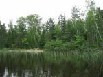

 [paragraph break] Mystery unsolved, we continue on into Pine Creek. There are plenty of water lilies and even some of their tubers floating on the surface (pulled up by wind or wave action? uprooted by some animal?). The portage into Chad is easy to spot, but we're headed for Pine Lake today. [paragraph break]

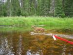
 [paragraph break] There's a very closed-in, private feel to the little creeks and rivers we've been paddling on this trip. I suppose there could be twenty people on the water but we'd never be able to see them with the sedges blocking our view and the zig-zagging bends shortening our line of sight. We know there are birds here though--lots of birds. We can hear them everywhere. Not just the Little Annoying Bird (which I just learned is actually a White-throated Sparrow), but lots of, um, Other Birds too. The only other one I could identify was a Red-winged Blackbird, but really, there were lots of birds. [paragraph break] We're nearing Pine Lake when, from a hill on our right, we hear something scrambling in the bushes. We stop paddling and watch a little fawn come prancing down the hill into the creek. Instead of crossing to the other side like we thought, the fawn starts swimming down the middle of the channel not ten feet from us. We drift to the bank and watch as it swims (and wades) right by us, around the bend, and out of site. After checking out the remains of an old bridge, we continue to Pine Lake. [paragraph break]
 [paragraph break] There on Pine Lake we smell campfire smoke and, halfway through our third day, see our first person. Of course I didn't take a picture of the guy, but after posting pictures of all the other unusual things we've seen on the trip, I am feeling the intense urge to document this rare Homo sapiens canoeus fishermanas sighting with a photo. As we pass, Eric asks how the fishing is. The guy responds but is clearly not as enthralled with us as we are with him. We paddle on and start scoping out campsites. [paragraph break] The western site on the island is beautiful--lots of Norways and a few white pines--so we claim it as ours. Stopping this early is nice. We finish our lunch, set up the tent (looked like rain again), and break out the hammock for the first time this trip. Eric had been skeptical about the whole hammock idea, but swinging in the gentle breeze while looking out over the lake he has been converted... I wish I'd made him one of his own. [paragraph break]

 [paragraph break] Eventually I'm able to drag him out of the hammock with the prospect of going fishing. Eric catches a little northern but throws it back. He catches a nice log too but we leave that for the beavers. We troll around awhile longer and he has a few nibbles, but when he snags on another log, he's not as lucky as the first time and loses his lure. I'm getting tired and we're both getting hungry so we head back to camp to start dinner. [paragraph break] A light rain begins to fall. The gentle patter intensifies and our noodles are starting to get a little soupy. By now we have the get-camp-cleaned-up-quick-because-it's-going-to-rain drill down pat. But the darkest clouds pass us by and we enjoy a calm, quiet evening. There's a nice little point where we watch the sun set and are entertained by three loons showing off for two others farther up the lake. A couple of guys paddle by and, grinning, apologize for catching a whopping Northern in front of our site (Eric is gracious, but I can tell he's also jealous). We skip some rocks when they've gone. Eric's pretty good considering the granite chunks he's trying to work with. [paragraph break]

[paragraph break] Mystery unsolved, we continue on into Pine Creek. There are plenty of water lilies and even some of their tubers floating on the surface (pulled up by wind or wave action? uprooted by some animal?). The portage into Chad is easy to spot, but we're headed for Pine Lake today. [paragraph break] [paragraph break] There's a very closed-in, private feel to the little creeks and rivers we've been paddling on this trip. I suppose there could be twenty people on the water but we'd never be able to see them with the sedges blocking our view and the zig-zagging bends shortening our line of sight. We know there are birds here though--lots of birds. We can hear them everywhere. Not just the Little Annoying Bird (which I just learned is actually a White-throated Sparrow), but lots of, um, Other Birds too. The only other one I could identify was a Red-winged Blackbird, but really, there were lots of birds. [paragraph break] We're nearing Pine Lake when, from a hill on our right, we hear something scrambling in the bushes. We stop paddling and watch a little fawn come prancing down the hill into the creek. Instead of crossing to the other side like we thought, the fawn starts swimming down the middle of the channel not ten feet from us. We drift to the bank and watch as it swims (and wades) right by us, around the bend, and out of site. After checking out the remains of an old bridge, we continue to Pine Lake. [paragraph break] [paragraph break] There on Pine Lake we smell campfire smoke and, halfway through our third day, see our first person. Of course I didn't take a picture of the guy, but after posting pictures of all the other unusual things we've seen on the trip, I am feeling the intense urge to document this rare Homo sapiens canoeus fishermanas sighting with a photo. As we pass, Eric asks how the fishing is. The guy responds but is clearly not as enthralled with us as we are with him. We paddle on and start scoping out campsites. [paragraph break] The western site on the island is beautiful--lots of Norways and a few white pines--so we claim it as ours. Stopping this early is nice. We finish our lunch, set up the tent (looked like rain again), and break out the hammock for the first time this trip. Eric had been skeptical about the whole hammock idea, but swinging in the gentle breeze while looking out over the lake he has been converted... I wish I'd made him one of his own. [paragraph break] [paragraph break] Eventually I'm able to drag him out of the hammock with the prospect of going fishing. Eric catches a little northern but throws it back. He catches a nice log too but we leave that for the beavers. We troll around awhile longer and he has a few nibbles, but when he snags on another log, he's not as lucky as the first time and loses his lure. I'm getting tired and we're both getting hungry so we head back to camp to start dinner. [paragraph break] A light rain begins to fall. The gentle patter intensifies and our noodles are starting to get a little soupy. By now we have the get-camp-cleaned-up-quick-because-it's-going-to-rain drill down pat. But the darkest clouds pass us by and we enjoy a calm, quiet evening. There's a nice little point where we watch the sun set and are entertained by three loons showing off for two others farther up the lake. A couple of guys paddle by and, grinning, apologize for catching a whopping Northern in front of our site (Eric is gracious, but I can tell he's also jealous). We skip some rocks when they've gone. Eric's pretty good considering the granite chunks he's trying to work with. [paragraph break]
Part 6 of 9
Summary: A 5-day loop from Baker up the Temperance lakes to Cherokee, and back through Sawbill and Smoke lakes back to Baker. A fairly difficult trip.

Day 0: We drove up from Stillwater in the morning and camped at one of the 5 walk-in campsites at Baker Lake, and it was nice.


Day 1 (Baker to S. Temperance) - A beautiful day, we decided to paddle all the way to South Temperance the first day which was a great paddle with easy portages except for the last one. We picked the campsite on top of a huge rock that was close to the middle of the lake. Tried fishing some but no luck


Day 2 (Rest) - In the night, we encountered the worst storm of the entire season. While we were there 19 people had to be rescued from the BWCA. We had about 50mph straightline winds, and I'm still surprised that the huge tent we had stood up to it. We slept in and took a rest day because of the intense winds. Amazingly beautiful sunset.


Day 3 (S. Temperance to Cherokee) - We left as early as we could to beat the heat, but it was no good. The lengthy, hilly portages were challenging and by the last portage we were pretty beat. We overpacked and single portaged which led us to speedier exhaustion. Still amazing weather. North Temperance was a beaut- I wish we had stayed there instead of South. We took the southeasterly facing campsite on Cherokee on the southeastern skinny island. Neat little site.

Day 4 (Cherokee to Sawbill) - Left a little later in the day but it was ok. We took our time going down the river letting out of the southwest part of Cherokee and it was a great area. BEWARE: The area between Ada and Skoop Lakes appears to be floatable, but a dam built recently has made the portion impossible to float. Be prepared for a long portage through muck and water. A guy that we saw there said he had been going to the BWCA for 40 years at least once per year and it was the worst portage he had ever seen. By the time we got to Sawbill it was pretty hot. We paddled all the way down to the site next to the portage onto Smoke.

Day 5 (Sawbill to Baker) - Cooler, cloudier weather for the first time on the trip. We were pretty hungry (I underpacked food a little and I felt really bad) and we were taunting each other with vivid descriptions of the burgers we were going to eat ASAP after getting out. We paddled back to Baker and returned our gear to Sawtooth outfitters.
Overall great route.
Day 0: We drove up from Stillwater in the morning and camped at one of the 5 walk-in campsites at Baker Lake, and it was nice.
Day 1 (Baker to S. Temperance) - A beautiful day, we decided to paddle all the way to South Temperance the first day which was a great paddle with easy portages except for the last one. We picked the campsite on top of a huge rock that was close to the middle of the lake. Tried fishing some but no luck
Day 2 (Rest) - In the night, we encountered the worst storm of the entire season. While we were there 19 people had to be rescued from the BWCA. We had about 50mph straightline winds, and I'm still surprised that the huge tent we had stood up to it. We slept in and took a rest day because of the intense winds. Amazingly beautiful sunset.
Day 3 (S. Temperance to Cherokee) - We left as early as we could to beat the heat, but it was no good. The lengthy, hilly portages were challenging and by the last portage we were pretty beat. We overpacked and single portaged which led us to speedier exhaustion. Still amazing weather. North Temperance was a beaut- I wish we had stayed there instead of South. We took the southeasterly facing campsite on Cherokee on the southeastern skinny island. Neat little site.
Day 4 (Cherokee to Sawbill) - Left a little later in the day but it was ok. We took our time going down the river letting out of the southwest part of Cherokee and it was a great area. BEWARE: The area between Ada and Skoop Lakes appears to be floatable, but a dam built recently has made the portion impossible to float. Be prepared for a long portage through muck and water. A guy that we saw there said he had been going to the BWCA for 40 years at least once per year and it was the worst portage he had ever seen. By the time we got to Sawbill it was pretty hot. We paddled all the way down to the site next to the portage onto Smoke.
Day 5 (Sawbill to Baker) - Cooler, cloudier weather for the first time on the trip. We were pretty hungry (I underpacked food a little and I felt really bad) and we were taunting each other with vivid descriptions of the burgers we were going to eat ASAP after getting out. We paddled back to Baker and returned our gear to Sawtooth outfitters.
Overall great route.
Part 7 of 9
Friday, July 18, 2008 [paragraph break] A gloriously lazy day. We eat breakfast and I take a nap. We play board games, we chat with the family and show off our trip pictures. We go sailing on White Iron and laze in the hammock by the shore. I have not been so decidedly lazy in a long time. The perfect way to spend the first day back in civilization.
Part 8 of 7
Saturday, July 19, 2008 [paragraph break] White Iron Lake--Farm Lake [paragraph break] Another relaxing day. We take the kayak out for a leisurely paddle to Farm Lake and when we return we finish stowing the camping gear and packing our bags. After a nice steak dinner, we head out for a night on the town with Eric's brother and his friends. When closing time rolls around, we go back to the house and sit on the dock watching the moon and stars shimmer in the lake until the mosquitoes drive us indoors.
Part 1 of 7
Sunday, July 20, 2008 [paragraph break] One last look at the lake, then we gather our things and head to the airport. We had wonderful trip. Simply being together is amazing for us (we currently live 2,000 miles apart). Add the beauty of the Boundary Waters to that and, really, who could want more?