BWCA Entry Point, Route, and Trip Report Blog
September 28 2025
Entry Point 57 - Magnetic Lake

Magnetic Lake entry point allows overnight paddle only. This entry point is supported by Gunflint Ranger Station near the city of Grand Marais, MN. The distance from ranger station to entry point is 47 miles. Access Magnetic Lake and Granite River from Gunflint Lake. This area was affected by blowdown in 1999.
Number of Permits per Day: 3
Elevation: 1554 feet
Latitude: 48.0969
Longitude: -90.7621
Brant to Tuscarora via Little Sag Route:
Round
Brant
Bat - Mud
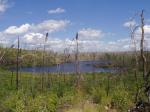
Gillis - burn area is evident:
French
Peter - first lake trout:

Virgin
Little Sag - green trees again!
Mora - gorgeous divide of burn and green
Crooked
Owl
Tuscarora - second lake trout!
Missing Link - with lighter food pack, the portage is OK
Round
Number of Permits per Day: 3
Elevation: 1554 feet
Latitude: 48.0969
Longitude: -90.7621
Brant to Tuscarora via Little Sag Route:
Round
Brant
Bat - Mud
Gillis - burn area is evident:
French
Peter - first lake trout:
Virgin
Little Sag - green trees again!
Mora - gorgeous divide of burn and green
Crooked
Owl
Tuscarora - second lake trout!
Missing Link - with lighter food pack, the portage is OK
Round
Family of three - on trip three!
by MN_Lindsey
Trip Report
Entry Date:
September 01, 2016
Entry Point:
Lizz and Swamp Lakes
Number of Days:
4
Group Size:
3
Trip Introduction:
Report
Had a great time up the Gunflint Trail with my family over Labor Day weekend! We put in on Poplar and paddled to the Lizz portage to enter the BWCA and basecamp on Horseshoe.
Full trip report with photos and photos can be viewed here:
Huntin’, Fishin, & Lovin’ Everyday!
.
discuss this trip report (9 comments) - last post on October 03, 2016