BWCA Entry Point, Route, and Trip Report Blog
September 14 2025
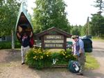
Entry Point 39 - Baker Lake

Number of Permits per Day: 2
Elevation: 1497 feet
Latitude: 47.8452
Longitude: -90.8169
Summary: A 5-day loop from Baker up the Temperance lakes to Cherokee, and back through Sawbill and Smoke lakes back to Baker. A fairly difficult trip.

Day 0: We drove up from Stillwater in the morning and camped at one of the 5 walk-in campsites at Baker Lake, and it was nice.


Day 1 (Baker to S. Temperance) - A beautiful day, we decided to paddle all the way to South Temperance the first day which was a great paddle with easy portages except for the last one. We picked the campsite on top of a huge rock that was close to the middle of the lake. Tried fishing some but no luck


Day 2 (Rest) - In the night, we encountered the worst storm of the entire season. While we were there 19 people had to be rescued from the BWCA. We had about 50mph straightline winds, and I'm still surprised that the huge tent we had stood up to it. We slept in and took a rest day because of the intense winds. Amazingly beautiful sunset.


Day 3 (S. Temperance to Cherokee) - We left as early as we could to beat the heat, but it was no good. The lengthy, hilly portages were challenging and by the last portage we were pretty beat. We overpacked and single portaged which led us to speedier exhaustion. Still amazing weather. North Temperance was a beaut- I wish we had stayed there instead of South. We took the southeasterly facing campsite on Cherokee on the southeastern skinny island. Neat little site.

Day 4 (Cherokee to Sawbill) - Left a little later in the day but it was ok. We took our time going down the river letting out of the southwest part of Cherokee and it was a great area. BEWARE: The area between Ada and Skoop Lakes appears to be floatable, but a dam built recently has made the portion impossible to float. Be prepared for a long portage through muck and water. A guy that we saw there said he had been going to the BWCA for 40 years at least once per year and it was the worst portage he had ever seen. By the time we got to Sawbill it was pretty hot. We paddled all the way down to the site next to the portage onto Smoke.

Day 5 (Sawbill to Baker) - Cooler, cloudier weather for the first time on the trip. We were pretty hungry (I underpacked food a little and I felt really bad) and we were taunting each other with vivid descriptions of the burgers we were going to eat ASAP after getting out. We paddled back to Baker and returned our gear to Sawtooth outfitters.
Overall great route.
Duncan to Gunflint
Entry Date:
July 27, 2014
Entry Point:
Duncan Lake
Exit Point:
South Lake (58)
Number of Days:
4
Group Size:
2
Breakfast was the first morning eggs (all broken due to rough handling) and bacon. The propane stove given to us was a simple affair, with a small burner on top of a pounder, and a plastic stability base. 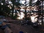 I cooked the bacon first, alternately burning parts and leaving other parts less done on the dented frying pan. After removing the bacon, I left the burner on while preparing the eggs. Well, I spent too much time preparing the eggs, which led to the bacon grease hitting flash point, creating a nice fire. Since the stove was on the fire grate, I poured the burning grease onto the bacon wrapping paper sitting on the grate, making a better fire than we had the prior evening. I then went forward with cooking the eggs with cheese in them. It turned out pretty well. By this omen, we set off on Rose.[paragraph break] Rose was a long paddle as the western part seems to be almost a river.[paragraph break]The Rat Lake portage (4 rods, 136 feet) was just a bit of lifting over some rock to bypass the rapids - just an unload and luggage carry.
 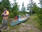 We took a small break at the portage, eating some snacks. When we went back to pick up our backs, my friend saw a sizable ribbon snake heading off into the bushes - he must have been sunning on the rocks when we arrived.[paragraph break]Rat lake was little more than a puddle, taking not much more than 15 minutes to traverse, even with lazy paddling. [paragraph break]The South Lake portage headed off into the darker woods surrounding the rapids between South Lake and Rat Lake, so we couldn't see what was ahead. As we traversed this path, we found out that it crossed the stream of the rapids, with some widely-spaced and slippery rocks to navigate. This portage was a good uphill, leaving me panting at the top. [paragraph break]South Lake was quite windy, which led to 1-1½ft waves. We foolishly just crossed the lake in a direct path, rather than hugging a shoreline, arriving tired and beaten to the campsite right by the Height of the Land portage.
 [paragraph break]We were able to get a tarp up over the kitchen area, which helped, as rain was coming. In fact, the rain started coming in waves, build for 10 minutes, then quit and then sun. It was a strange phenomenon for sure.[paragraph break] Later on, we heard a group coming out of the portage as we made dinner. After eating, and cleaning up, we still heard them coming out of the portage, so we investigated. It turns out the 9- person group had lost shoes on the Height of the Land, and had spent much time digging them out. Of course, these were camping sandals, and not hiking boots. We also explored the west side of South since the wind died down, and saw a beaver building a lodge down one of the side bays. We sat and watched him for awhile, but left after he slapped at us twice (certainly an expression of his displeasure of us being there). Back to camp, and more hiding under the rain tarp as another storm rolled in. This time, though, we had pea-sized hail!
  We learned this time that having a shelter up is a good thing! [paragraph break] Bedtime was soon after, as the mosquitoes also liked our shelter, and decided to feed while they were hanging around.
Breakfast was the first morning eggs (all broken due to rough handling) and bacon. The propane stove given to us was a simple affair, with a small burner on top of a pounder, and a plastic stability base. I cooked the bacon first, alternately burning parts and leaving other parts less done on the dented frying pan. After removing the bacon, I left the burner on while preparing the eggs. Well, I spent too much time preparing the eggs, which led to the bacon grease hitting flash point, creating a nice fire. Since the stove was on the fire grate, I poured the burning grease onto the bacon wrapping paper sitting on the grate, making a better fire than we had the prior evening. I then went forward with cooking the eggs with cheese in them. It turned out pretty well. By this omen, we set off on Rose.[paragraph break] Rose was a long paddle as the western part seems to be almost a river.[paragraph break]The Rat Lake portage (4 rods, 136 feet) was just a bit of lifting over some rock to bypass the rapids - just an unload and luggage carry. We took a small break at the portage, eating some snacks. When we went back to pick up our backs, my friend saw a sizable ribbon snake heading off into the bushes - he must have been sunning on the rocks when we arrived.[paragraph break]Rat lake was little more than a puddle, taking not much more than 15 minutes to traverse, even with lazy paddling. [paragraph break]The South Lake portage headed off into the darker woods surrounding the rapids between South Lake and Rat Lake, so we couldn't see what was ahead. As we traversed this path, we found out that it crossed the stream of the rapids, with some widely-spaced and slippery rocks to navigate. This portage was a good uphill, leaving me panting at the top. [paragraph break]South Lake was quite windy, which led to 1-1½ft waves. We foolishly just crossed the lake in a direct path, rather than hugging a shoreline, arriving tired and beaten to the campsite right by the Height of the Land portage. [paragraph break]We were able to get a tarp up over the kitchen area, which helped, as rain was coming. In fact, the rain started coming in waves, build for 10 minutes, then quit and then sun. It was a strange phenomenon for sure.[paragraph break] Later on, we heard a group coming out of the portage as we made dinner. After eating, and cleaning up, we still heard them coming out of the portage, so we investigated. It turns out the 9- person group had lost shoes on the Height of the Land, and had spent much time digging them out. Of course, these were camping sandals, and not hiking boots. We also explored the west side of South since the wind died down, and saw a beaver building a lodge down one of the side bays. We sat and watched him for awhile, but left after he slapped at us twice (certainly an expression of his displeasure of us being there). Back to camp, and more hiding under the rain tarp as another storm rolled in. This time, though, we had pea-sized hail! We learned this time that having a shelter up is a good thing! [paragraph break] Bedtime was soon after, as the mosquitoes also liked our shelter, and decided to feed while they were hanging around.
The Height of the Lands portage was as described to us, a muddy mess, with a river heading down the trail into South Lake. It was still neat to see the monuments, and I mounted a camera on the canoe to film the entire portage.[paragraph break] After completing the portage, we stood in the waters of North Lake, and completed our Voyager's ceremony - sprinkled each other with a wetted balsam branch, vowed to do this ceremony with another newbie when we crossed over, vowed to never kiss another voyager's wife (unless she asked), and then took a swig of rum. We didn't have guns, so we couldn't do the gunfire :)[paragraph break] The crossing of North was nice - 68°, sunny, and little wind. We took off left, which led us into confusion as the bays of North are deep. We eventually ended up in Canada as we tried to determine where the channel to Little North Lake was, and saw the boundary markers: 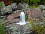 We finally settled into a decision, and found the right channel, gliding up between the banks and listening to the birds. [paragraph break]I wondered how we would identify Little North Lake, but it was really apparent to see, as there was two peninsulas of weeds separating.[paragraph break] The rapids between Little North Lake and Little Gunflint lake seemed to be navigable (with an experienced team), but we took the portage, which was an old boat transport rail system for most of the portage:
 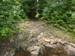 Since it was wide and short, we unloaded, pulled the packs across, then luggage-carried the canoe over. [paragraph break] We ran into a few Scout groups going across Little Gunflint, and eyed the thunderstorms brewing in the north. As we got across Little Gunflint, the storms began in earnest, and we paddled hard to get off the lake, stopping at the beach on the west end of Gunflint while watching the weather cross the big lake (and, of course, joking that we have a beach vacation as well, with boat drinks.
 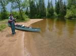 [paragraph break] After the weather broke, we headed to our final campsite - Camper's Island, which was right aside of Bridal Falls. This was an awesome campsite, with even a picnic table!
 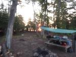 We spread out a tarp to handle the inevitable rain, made dinner, and generally relaxed on this little oasis. Even the latrine is fun, since it sat in a circle area of dense pines, with the path directly to it (we called it the Throne Room):
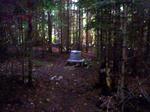 The campsite is evidently popular, since 2 other groups decided to come by later. Dinner, and a bedtime chase by the mosquitoes.
Waking up early, I got a few shots of the sunrise over Gunflint, with the morning mist hovering between the islands: 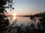 Packing up and launching early into the calm water, we anticipated a smooth paddle back to Gunflint Northwoods Outfitters. Well... [paragraph break] the winds on Gunflint did not cooperate, and were fetching straight from the west, making 1½-2ft waves. Of course, this was right in our face too, so progress was slow. We took to a strategy we called "dock hopping", where we would rest periodically by holding the end of the cabin docks on the southern shore..
2 hours later, we arrive at Gunflint Lodge, and portaged our way back: