BWCA Entry Point, Route, and Trip Report Blog
April 25 2024
Entry Point 4 - Crab Lake & Cummings Lake

Number of Permits per Day: 3
Elevation: 1406 feet
Latitude: 47.9337
Longitude: -92.0269
Crab Lake & Cummings Lake - 4
First Solo - Crane to Gunflint - September 2007
Entry Date:
September 07, 2007
Entry Point:
Little Vermilion Lake (Crane Lake)
Exit Point:
Magnetic Lake (57)
Number of Days:
6
Group Size:
1
The things I like about the BWCA are 1. time with Amy, 2. time with friends, 3. Hot days laying in the lake, 4. relaxing in the hammock, 5. fishing, 6. dawdling. I realized on my last day, that I had done NONE of those things. I wasn't having a lot of fun and I was in pretty rough shape physically. Time to go home.
I'm glad I did the trip, and even thought I didn't make it to Superior, and probably will never go solo again, I think I still accomplished a lot. Although I did wake up this morning thinking "I should have kept going." Easy to say after a night in a warm bed, a hot meal, and visit with your loved ones. I'm sure I made the right and safe decision.
Day 0, Thursday September 6, 2007, Chisago City – Babbitt I'm all packed up and ready to head out by 6pm. It's been a hot week, but a dramatic drop in temperatures and some rain is in the forecast for my trip. I prefer hot. Oh, well. I take a picture of my girls next to the canoe so that I can look at them in the camera if I get lonely. This later proves insufficient to quell my lack of affection for solitude. I hit the road, on the way stopping at my friend Tom's house, where he has been downloading detailed map data from his computer to his GPS, which I am borrowing. In spite of some technical glitches, solved with assistance of his able wife Robin, he gets the detail downloaded. THIS will later prove over and over again to be a great addition to my gear bag, a tremendous time saver on the lakes, and an amusing way to keep myself occupied as I try to keep myself on course out on the water. My other friend Tom has provided the other very expensive item of equipment for the trip: his Bell Magic solo canoe, a great boat that I name "Homer" due to the first letters of the serial number spelling out "DOH". During the course of the trip, every hint of rock scrape is accompanied by an audible "Sorry Tom" from yours truly. At 10pm, I hit Babbitt, where I am staying with Amy's dad, Chuck, and his partner, Carol. This is the day, of course, where the Ely area got around 10 inches of rain. So I arrive to no power…very dark. I have a flashlight, of course!
Day 1, Friday September 7, 2007, Babbitt-Ely-Crane Lake-Lac La Croix 20 miles traveled, 5:46 hours moving, 0:23 stopped, Moving avg. 3.4 mph, Overall avg. 3.2 mpg Lakes: Loon Lake, Lac La Croix Portages: 60 r. Beatty Portage
Day 1 starts out as day zero ended: dreary and overcast, but with me filled with hope and anticipation about the journey that lies ahead. I wake up pretty early, but without much need, as we have until noon to get to Crane Lake to meet my shuttle boat captain at Anderson Outfitters, who will take me across Crane and down the Little Vermillion River on the first leg of my trip. We hit the ranger station in Ely at 8am to get my permit, with a quick stop to pick up a bailing sponge (another great late addition to my equipment set). I left the bailing sponge on the floor in front of me (attached by a strap so I can tug it back to squeeze it out, and so that it hangs on portages) so the splash as I switch sides with my paddle gets absorbed by the sponge without drifting aft to get my feet wet. We head up the Echo Trail and are at Crane by about 10am. They drive me down to the landing, and I unload my gear and wait for the group of 5 that are heading into the Quetico that I am piggybacking with, which allows Mark at Anderson to give me a better rate on the boat ride. I have to wait rather than going early, but I saved a lot of $$$ American. 
One note on the shuttle: I chose to bypass paddling the Little Vermillion after a couple of outfitters and several books told me that it can be rough waters for a canoe given the narrowness of the river and the speed at which the motorized boats run the river. After riding in a motorized boat down the river, I am glad I made the choice. It is very narrow, and these guys are running big aluminum boats with 225 horse outboards on them. I pulled out the GPS at one point and we were doing 40mph…around a corner! Anyway, the shuttle ride itself was worth the price of admission!
The guys I am riding with show up at 11am, and man are they packed heavy! We laugh about my load compared to theirs, but they will have more drinking and fishing choices than I do. They are a good crew, most from Kentucky with one transplanted to MN, and everything gets loaded and we are at customs on Crane Lake by 12:10. After doing what has to be done, we head up river. By 1pm, we are at and over the motorized portage at Loon Falls, which is where I get off. I pack some of my clothes, as I started the day in a long john top and a t-shirt and my fleece jacket, and by this time am down to the t-shirt.
Heading across Loon Lake, I'm struck a bit by what I'm doing. All alone, heading into the wilderness with all this mileage spread out in front of me. I'm pretty delighted to have a sunny warm day to start, and really am enjoying the paddle. I am mostly using my bent shaft Bending Branches paddle, but I have a Bending Branches kayak paddle that I will try out as well, on the theory that I will make better time with it. Going across Loon, I see one more tow boat, empty, coming back from Lac La Croix, otherwise nothing. This looks like a nice little lake to hang out on, but I'm moving on.
I hit the Beatty portage, my first chance to see how single portaging is going to be. This is only a 60 rod portage, and it looks like you are hiking across someone's lawn as you walk next to the rails for the mechanized portage, so this is a good one to break myself in on. I seem to be exerting myself a little more than I expected I would, but figure it's because this is the first portage. I unload and head north onto Lac La Croix, right into a headwind. Not a lot of chop, so it can't be that strong of a wind, but enough to impede my progress a bit, although later I figured out I was averaging about 3.5 mph into the wind, so not too bad. One weird part about this part of Lac La Croix is all the cabins on the Canadian side. Very strange to see. Some nice cliffs on this side of Lac La Croix (I have only been on the east end before), which has always been one of my favorite lakes. Heading past Sandbar Island, which looks pretty cool, I am passed by Mark from Anderson's, heading home after dropping off the Kentuckians.
By now the sky is pretty well overcast, and I've got my rain jacket ready to go, just in case. For this trip, I've finally bought some good rain gear, so I am, in a perverse way, looking forward to a little rain to try it out on! After going around the corner and making the turn to the east, I get my chance. As I'm cruising through the mishmash of islands around Fortyone Island (and thanks again to Tom for the use of the GPS), I get hit by a real heavy rainstorm, at right around 5 pm. I'm in a protected channel, but as far as I can see, the lake is calm except for the froth thrown up by the raindrops hammering down. Since its calm, I keep moving, but I figure if things keep up, I'll look for a campsite around here, otherwise, I'll scoot the gap to Twentyfive Island and camp on that end.
By 6 pm, the rain has stopped, and I get a nice rainbow. There's a distinct line behind the storms, and I can tell from the blue sky that it should be a nice evening.
Rainbow on Lac La Croix: 
Storm Line on Lac La Croix 
I press on, and decide that, given what I know about Lac La Croix, a more protected route might be beneficial in the morning, so I make plans to head down the western end of Coleman Island, so I'll be protected in the case of winds in the morning. I find a campsite at around 6:30 pm before I head into the narrows, with a nice high (20-25 foot) fire grate looking south into the western narrows of Coleman. Setting up camp is pretty straightforward: I have a 10x10 nylon tarp I throw up, and then put the entrance to my tent under that, so I've got a dry "porch" area in case of rain. Then I find a branch to hoist my food up to after eating, to keep it from the bears. I've packed all my food in a separate clear dry sack, so that I can hoist it without worrying about it getting wet. During the day, the clear sack goes into my duluth pack behind my seat. I did try putting the clear food sack into the front of the canoe one day for trimming purposes, but noticed no difference, so it stayed in the duluth pack the rest of the trip.
Supper is a dehydrated Spicy Thai Chicken. I am transported into the back streets of Bangkok as I munch the soupy mess I've made, but then the cry of a couple wrangling loons out front of camp brings me back to the good old BWCA, and the realization that this is not really Thai tasting, or spicy, and I don't see much chicken.
I think it's around this time, after camp is set up, that I begin to realize that being alone can be lonely. I obviously knew that I was going to be alone, but I guess I didn't realize what it would be like until I actually experienced it (which, obviously, is one of the reasons for doing this type of trip). I'm looking at the GPS, and in my effort to save memory (or something) I accidentally delete the "track" I left today by leaving the GPS on during my travels. Oops. Tired, I hit the hay at dusk and set the alarm for 6am.
Camp on Lac La Croix 

Day 2, Saturday September 8, 2007, Lac La Croix-Basswood River 31 miles traveled, 8:54 moving, 1:34 stopped, Moving avg. 3.5 mph, Overall avg. 2.9 mpg Lakes: Lac La Croix, Bottle, Iron, Crooked Portages: 80 r. Bottle Portage, 140 r. Curtain Falls Portage
Sunrise on Lac La Croix: 
I wake to fairly clear skies on Saturday morning, and relatively warm temps. I've had a bit of rain overnight, so everything is damp. Breakfast is oatmeal. Yesterday, I made the mistake of not packing lunch into my day pack, so I remember to do that today so that I don't have to dig around in the food pack during the day. I am eating Clif energy bars and GORP for lunches, so I take my pick of flavors, and grab 2 Crystal Light single serve drink mixes and put those in my day pack. For water, I have a 32 oz. Nalgene bottle that I fill whenever I'm thirsty, that takes 2 of the single use drink mixes to flavor (I prefer the strawberry energy ones during the day and peach tea or lemonade in the evening). When I get set to stop at my campsite, I also fill a 2 liter collapsible platypus jug so that I have all my meal and drinking water needs taken care of without having to take the canoe out again in the morning. I have brought a filter this trip, just in case I get stuck on a river or somewhere I'm not willing to drink water straight. But, I've been drinking unfiltered lake water for 25 years and never had an issue, so my basic plan is to keep the filter stowed.
Panoramic photo looking up the pictograph cliff: 
Heading out, I move south around Coleman Island and east through Fish Stake narrows. I am a bit disappointed not to see the fish stake (whatever that is), but what the heck, you can't have everything. Straight east and a bit south of the narrows "pictographs" are noted on my map. I head toward a grouping of them and find them, as advertised, at the base of spectacular cliff. It is a pretty amazing experience to sit here and try to picture people painting this stuff on the cliff walls and having it last so long. There is a beautiful moose, very clear, and some other images that might also be moose, and maybe a canoe. There are also a lot of very clear handprints, some of which seem to be ten to twelve feet off the water surface. Now, granted, the water was most certainly much higher than it is now, but I kept having this image of one person sitting on another's shoulders while making handprints! Everyone pretty much acknowledges the importance of these paintings in native culture, but I started thinking "What if these pictographs are just graffiti?" I mean, maybe instead of tagging a rail car, native teens headed out and marked up the cliff walls. Then the elders would have to jump on them about being irresponsible and wrecking the earth and stuff, so that's why there aren't many of them. Maybe not.
Pictographs: 


I head out and curve around toward the east at the base of Warrior Hill. My first trip to the BWCA was in 1981 or so, and we traveled to Lac La Croix. I remember visiting warrior hill, Curtain Falls and Rebecca Falls. Our honeymoon, in 1991, was to Lac La Croix, and Amy and I stayed on the island to the south of Warrior Hill that we call Professor's Island, so this area is pretty sweet for me. It brings back lots of good memories. On this trip, being alone, it makes me a little wistful as well. I see someone camping on the north end of Professor's island, a canoe heading toward warrior hill, and I saw a boat with people fishing off the pictographs. These will be the only people sightings I have today, until the very end of my day.
That's one of the strange parts of this trip for me. Even in the BWCA, I'm used to seeing people, and because I'm not usually alone up here, I'm usually interacting with people. Also, I have a pretty outgoing personality, so being able to chat and laugh is a big part of who I am. This forced deprivation of human contact is hard for me, and I suspect that as the days go on, I will be latching on to people at portages and who are passing me by on the water to talk their ears off.
Next stop is the bottle portage. I have only done this portage two other times, and both were years ago, so I don't really remember what its like. I do remember hearing that it’s a muddy portage, but I'm hoping that our dry weather will have tamed that a bit. I unload at the beginning of the portage, get everything ready to pack over in one trip. Again, I'm a bit uncomfortable with the load as I head over the portage. About halfway across, after fighting to get the front of the canoe up, I realize that my pack is hitting the seat, which is right behind the yoke, and forcing the canoe into an uncomfortable position on my neck, and making me shift over and over to try to get the balance right. Not realizing I'm twenty or so yards from the end of the portage, I finally give up and lay the canoe down.
My first glimpse of the Bottle end of the portage is not encouraging. It looks like a giant mud flat. As I look closer, I realize that there are footprints going out 20-30 yards in the muck, where people have had to set their canoes down and shove everything out while walking through the mud since they can't float on the mud. There's also an abandoned flipflop out in the mud, 20 feet from shore, bearing silent testimony to the cruelty of a muddy portage. I imagine a teenager ('cause who else would be wearing a flipflop on a portage) limping down a portage trail with one flat tire, bemoaning the loss of that blue flipflop.
The portage itself WAS relatively dry, but the downside to our dry summer is obvious here at the landing. While walking back to get the canoe, I'm trying to think of an alternative to the mud walk. With the canoe, I head down the shore and find a spot where there are some rocks heading out through the muck. Then, I load the canoe and, holding the rope tied to the front of the canoe, I jump from rock to rock, skimming the canoe along the 2 inches of water on top of the muck. Amazingly, the technique works, and I am able to tug the canoe out to deep enough water to get in without every dipping my tootsies in the brown snot that lines the lakeshore.
End of Bottle Portage: 
Pleased with myself and happy to not have muddy feet, I head down Bottle Lake to the opening into Iron. As I'm paddling toward where the opening SHOULD be, I start thinking "I don't remember this rocky area!" Of course, another casualty of the low water this year is the opening between Bottle and Iron Lakes. Once I get close, I realize that there's about a 3 foot wide, 6 inch deep "stream" flowing through the jumble of boulders. So, I hop out and walk along the boulders, pulling the canoe through the little stream. Thankfully, there isn't much scraping, but I can't imagine getting through here even a couple days ago when the water was even lower.
"Opening" between Bottle and Iron Lakes 
I have a west wind today, which works out to be a nice tailwind as I head across Iron Lake. I'm taking the northern route around Four Island, so that I can scoot up and see Rebecca Falls on my way through. Rebecca is a twin falls around an island, which requires you to paddle across the top of the falls. This sounds more dangerous than it actually is, given how big the lake is above the falls. I remember my first trip here, paddling with all my might after my older brother and his friends told us we would get sucked down the falls with any false move! Obviously, you can get sucked down the falls, but it would take a series of very stupid moves to have that happen. Rebecca is a little low, which you can tell more on the east side than the west, but not as low as I've seen it on other trips. The west side churns like crazy, but I decide not to sit in the whirlpool, given I'm all by myself with no one to help if I lose my footing. After a few pictures and some GORP and the energy bar for lunch, I'm on my way again.
Rebecca Falls 
 At the top of Rebecca Falls
Next stop, Curtain Falls portage. I have never portaged this falls, only walked up the trail for fishing and picture taking. I've stood on the top, staring up Crooked Lake, feeling like I was on the edge of a vast unexplored territory, so finally heading into the lake will actually be pretty exciting. But first, find the portage. I can see the portage trail, but there's an island with rapids on either side of it between me and shore. I'm not 100% sure which way to go, so I head left of the island. I think, looking back, that this is the wrong choice. Or maybe it's just that I'm paddling alone, but I can't seem to get up enough steam to get through the faster water. So, once again, I hop out and line the canoe through the faster water.
I've been thinking about portaging technique, and deciding that until my pack gets smaller, or I figure something out, I'm going to have to double portage. I was thinking that I could make the 40-60 rod portages single packing, but then, those are the ones that are short enough where it doesn't take much time to go back and double portage. So, I've pretty much decided that in all cases, double portaging will be the way to go. I'm feeling a little dread about the Grand Portage, which lay ahead of me, thinking about walking 27 miles in a double portage. I worry about that one the whole time I'm paddling, thinking of various solutions. Ultimately (SPOILER ALERT), I don't have to worry about it, in that I don't make it that far!
Curtain portage is a bit steep at the beginning, but it's really a nice trail and a relatively easy portage to pull off. And the view once you finished is awesome. Curtain Falls is gorgeous, and everything I remembered it to be. It isn't flowing at full capacity, but it hasn't dried up enough to walk all the way across, either. I again take the time to snap a few pictures and hang out a little bit, but the call of Crooked Lake is beckoning, so I head out.
Curtain Falls: 

Ultimately, Crooked is a little disappointing, in that I've had expectations over the years about what might lie around that particular bend. In reality, it's not a particularly spectacular lake, but again, its fun to see what's around the next corner. I am surprised at the great number of sand beaches I see on Crooked, though. I make pretty good time with a tailwind across Crooked, passing Sunday, Saturday, Friday and Thursday bay without seeing a soul, either in canoe or at camp. At one point, a flock of around 100 Canada Geese honks their way overhead. They are a pretty spectacular sight!

Just as I turn south into Wednesday Bay, I pass two guys in a canoe, and chat for just a second. They let me know that the "Table Rock" campsite is the only one taken until Basswood Falls, and I let them know that they're the only people I've seen since Lac La Croix. Hooking through Wednesday Bay at around 5:30pm, the folks at the Table Rock site offer to share if I need, but I'm sure I have enough time to work my way down into the Basswood River to one of the sites there. "Be safe," shouts one of the guys as I head down the river. I get that a lot when I talk to people. It's nice to have a little bit of a feeling like others are watching out for you and care about your survival. On the safety front, it makes you, as a solo canoeist feel not so alone out there.
Around 6pm, I start getting sprinkled on, so I aim for the campsite on Crooked Lake (or the Basswood River, the GPS and the map are fighting about what to call the body of water I'm on) that sits in the narrows straight east of Frolic Lake. I have developed Traveling Guideline #1: Always aim to stop at a spot with at least 2 campsites nearby, that way you can (at this time of year) assume that at least one will be open and you will be able to stop without ENDANGERING YOURSELF (foreshadow). The camp is a neat little spot, with a nice view across the channel of some pine-studded hills. Everything goes up quickly and I enjoy a hot meal. Tonight is dehydrated chicken gumbo, which is actually spicy and pretty flavorful. And tonight, in an effort to NOT wipe out the GPS record of my day, I try saving my track. Someone it doesn't work, and thinking I've saved it, I delete it from the active memory, which apparently deletes it entirely. Oops again. Early to bed gets me ready to rise early. Cloudy again tonight.

Day 3, Sunday September 9, 2007, Basswood River-Knife Lake 30 miles traveled, 9:00 moving, 2:55 stopped, Moving avg. 3.4 mph, Overall avg. 2.6 mpg Lakes: Basswood River, Basswood Lake, Birch Lake, Carp Lake, Melon Lake, Portage Lake, Knife Lake Portages: 33 r. Lower Basswood Falls, 50 r. Wheelbarrow Falls, 30 r. rapids, 340 r. Basswood Falls, 20 r. Prairie Portage (Canadian side), 40 r. Birch-Carp, 25 r. Carp-Melon, 15 r. Carp portage, 15 r. portage, 75 r. Big Knife Portage
After covering 30 miles yesterday, and being pretty worn out, I've decided that I'm going to try to get across Basswood today and knock off a little early. But, you know what they say about the best intentions.
The day starts out pretty overcast again. This is getting kind of old! However, I have hope when I spot some little bits of blue up in the clouds. I'm taken with this end of Crooked, and impressed with some of the cliffs here:

I head downriver (actually upriver, I guess, but going south) and soon spot the Lower Basswood Falls portage on the Canadian side. There's a group camped on the American side, in what looks like a nice campsite for listening to the rushing water. This portage isn't particularly difficult, it’s a little narrow in spots, and it heads through what looks like a giant Quetico campsite. I'd be surprised if anyone would actually camp there, in that its RIGHT on the portage trail. Maybe it gets used a lot for lunch. On the east end of the portage, there's a portion that goes along a large rock that kind of has a high road and a low road. The low road is a little too close to the drop to the falls for my comfort, so I stick to the high road. I snap some pictures, and then it's off the sand beach and heading further up.
Lower Basswood Falls: 
My next stop is the Wheelbarrow Falls. This is another twin falls around an island, but not as spectacular as Rebecca Falls.
Wheelbarrow Falls: 
For this portage, there's a choice of going up 50 rods to the left of the falls on the American side or 32 rods on the Canadian side. If you choose the Canadian side, you get a slightly shorter portage, but have to paddle around the island to end up at the same point you end up if you take the American side portage. For that reason, and the general idea I've heard that the Canadian portages are not as well maintained, I head across the 50 rod. Its pretty rocky at the bottom and the top, and the top ends pretty far up from the top of the falls. There are quite a few places people have exited (or entered) the portage early, but I head to the end, hoping for a less rocky landing. It is less rocky there, but not by much. Oh well.
The next portage is a 30 rod around some rapids downstream from the main Basswood Falls. It was hard for me to figure out where the portage was until I got right up to it. Then I realized it is right on a big rock shelf at the bottom of the rapids. Again the portage was pretty easy, heading up a bit of a cliff face and then across a lot of big flat rock to the top. There's a campsite there with a nice pile of cut and split wood, but its not even noon yet, so I'm not ready to stop! Not to mention that the campsite is only twenty yards or so from the portage…my least favorite location for a campsite.
Just around the bend from this portage, I spot the first of many groups I will see around the main Basswood Falls. I suspect that this must be an extremely busy area for camping during the peak months, as this is the highest concentration of people I have yet to see while paddling up here.
The portage itself starts at a large rock that you have to climb up, and then heads on a pretty level path for the mile it takes to get through it. There are several places where people have beat down pretty good trails to see the falls, and there are logs laid over several wrong turns on the portage path. One spot in particular, where you hit a big expanse of open rock just as the portage trail takes a 90 degree turn to the right, is marked by a log and several rock cairns to keep you on track. Very helpful! There is also a part of the portage that crosses a stream from a swamp. This area has pretty good water in it, but is traversed by a well made path of stones you can walk across.
The falls themselves weren't the best ones I'd seen, but they were definitely large. It looked, too, as if most of the campsites were taken on the point in the middle of the falls. I saw half a dozen canoes pulled up at the Basswood Lake end of the portage trail, which made me wonder if you had to portage all your stuff out to those campsite that are between the beginning and the end of the portage trail. Also found a disposable camera in a foot of water on the Basswood Lake end of the portage. I put it on a rock, but I suspect that the pictures were in pretty rough shape after sitting in the water!
Basswood Falls: 


Basswood Falls Portage: (Cairns) 
(Stream with Rock Bridge) 
I then headed northeast toward United State point, with a tailwind. I wasn't hampered, either, as I turned South to head down the lake toward Canadian point, as much of the direct wind was stopped by U.S. point. To save a little time, I cut through the English Channel along the north end of Ottawa Island, and then hooked around the south side of Rookery Island. It was about 2pm, and the sun had come out at the beginning of Basswood, so I was down to shorts and my PFD, and really enjoying the day. On a whim, as I was having a snack just south of Rookery, I pulled out my cell phone. Amazingly, I had coverage! So, I dialed up Amy to tell her hello, and give her an update on my much quicker than expected progress. The girls were updating the map I left them, and I was chatting away merrily when the signal disappeared. Ah, well, a few moments of conversational bliss and a little peace of mind for Amy was well worth the "intrusion" of technology into my wilderness trip.
My trip across the bulk of Basswood was pretty uneventful. No one shot at me, for starters. I saw one group camped off Canadian point, and one group traveling that way, as well as three or four motor boats out fishing, but other than that, not much. As I headed up to Prairie Portage, I decided that I would take the shorter 20 rod portage on the Canadian side. This portage was right off the main beach by the Canadian customs area and the store that is there, and was well groomed and pretty easy. After dropping off the pack, I headed back down, but took a bit of a detour on another well-used trail, thinking I was heading back down the portage. Turned out it was the path to an outhouse! What luxury! Unfortunately, I had no use for it at the moment, and my opportunity to experience indoor plumbing (so to speak) was squandered.
Coming off the Prairie Portage at around 4:30pm, its interesting to note the large tube in the water which carries water around the spillway for use, I assume, by the Canadian Rangers for generating power. It is also interesting to note the large spillway dam at Prairie Portage. I'm very curious about the history of that dam, and look forward to finding out how it got there! There were a couple boats just coming off the motorized portage as I head out, and as a courtesy, they travel slowly past me before heading home. Sometimes slow creates a bigger wake than fast, however, and I have to turn into their wakes to make sure I don't get swamped.
Prairie Portage Dam 
Then I'm off to Birch Lake. Pretty much the whole time I'm on Birch Lake, I'm kind of creeped out. You can see the bones of a lot of trees that have been submerged by the dam at Prairie Portage. Going over them made me feel like walking in a graveyard. I know, weird. But I'm weird, so get over it. The other odd thing was how the rising water had taken a lot of the definition away from the shores of the lake. It seemed as if the lake was just a mishmash of trees right down to the water's edge. Regardless of this fact, in line with Traveling Guideline #1, I am aiming for the last bay of Birch Lake which has not two, but THREE campsites for my choosing pleasure, and will leave all the portaging into Knife Lake for when I'm fresh in the morning, NOT LATE AT NIGHT (foreshadow). On Birch, I've passed 3 occupied campsites, a MUCH higher ratio of occupied to unoccupied campsites than I have seen anywhere else on my trip (additional foreshadow).
By the looks of the campsites on my map, the third one is along some close topographic lines, indicating that it may well be up on a hill, which is my favorite kind of site. I head into the bay, noting that the first one is kind of dumpy…low, open, not the best. The second one looks nice and high, but as I get close, I realize there's a tent on it. Ok, well, I'll head for the third one. I'm scooting down the lake, when I realize that the third site is actually pretty close after the second one. Thinking that I'd rather not impede on someone else's wilderness experience by horning in on their space in this less traveled time of year, I decide to take the 40 rod portage into Carp Lake. This despite the fact that its now somewhere around 6pm, and I am violating my travel guidelines in heading into a lake that only has one campsite. But, what are the odds someone will stop on Carp Lake? I mean, it’s a crappy lake name, and there are nicer lakes (Knife and Birch) on either side of it. Of course, I make this rational determination after having only seen one of the three lakes in question.
ANYWAY, here comes the drama. I cross the portage into Carp, which isn't very dramatic. It's pretty short, sweet and level, with good landings on either end. I head to the peninsula where the campsite is located. At the point of the peninsula is a beautiful little camping spot! I head in, jump out of the canoe and check it out. Of course, given the lack of fire grate and the rock fire ring next to a big rock ledge, I rapidly conclude that this is not, in fact, the campsite. Although it should be! So I head back into the canoe down the peninsula, which looks totally deserted. Until I get close and see the dude in his blue rain gear putting up a tent. Dang. So now, the question is, do I head back to one of the open campsites? Do I camp on the illegal bivouac at the end of the peninsula, or do I head for Knife Lake? Since I don't want to go BACKWARD, and I don't want to camp illegally, and I have at least an hour of sunlight left, I foolishly decide to head across the 4 portages and 3 miles of paddling onto Knife Lake. Duh.
The first couple portages are pretty easy: short and flat and quick. Then I head upstream to Knife, with my eye toward the campsite just north of Dorothy's Island. My map shows a 15 rod and a 75 rod portage on the Canadian side of the river as one long unbroken line. I'm not sure how this can be, but I'm willing to wing it. As I come upon the peninsula to my left that supposedly houses the start of those portages, I see that there is a bit of a dip into a swampy area. My thought is that there is a short carry, then down into the swampy area and then the start of the long carry. So, I pull up to the trail that comes off the end of the point (even though the map makes the portage appear to be a bit further along the point) and take my pack up into the woods. Thirty yards in, the trail does a switchback between a few small pine trees (as my head goes "How am I going to get the canoe through here?") and then just disappears. I stand there staring, thinking, this is not good. Turning around, I whisper, well, okay, I yell a prayer "What am I supposed to do?" into the waning sunlight. God tells me to get back in my canoe, dummy, and keep looking, because this clearly isn't the portage.
So I head out, round the corner and there's a trail. On the American side. Huh? Hopping out, I walk it without any packs or gear, and find that it's short, maybe 20 rods or so, and pretty easy. Okay, I think, maybe this is the American side alternative to the 75 rod portage on the Canadian side. I head across the portage, getting more nervous as it gets darker, but thinking that I'm going to make it to Knife Lake way before dark by not having to do the 75 rod portage. It's about 7:30 as I finish the portages, with a 7:45 sundown and a large cloud already starting to obscure the sun in the western sky. Flying upriver toward Knife, I mark the campsite on my GPS, thinking I'll be able to find it even after dark. And then I spot the portage trail on the Canadian side. And then I hear the rapids. OK, I think, I now have at least a half hour of portaging before I see Knife Lake, because this has GOT to be the 75 rodder. Sure enough, it is. Again, though, this is a relatively flat, smooth portage, and I make good time, jogging back to get the canoe after my first trip over. But its still 7:45pm or so when I make it across. Now, KNOWING I'm on Knife, I head out across the silent calm water, eyes dead ahead looking for the island with the campsite on it, FOCUSED on the end of another long day on a day I wanted to take it easy. So focused, that I nearly wet my pants when a beaver slaps his tail 10 feet to my right with a noise like a gunshot. After my heart slows down, I look around a little closer and notice another beaver ahead and to my left and another ahead and to my right. This time, when they panic and slap, I'm ready for them, and don't nearly jump out of the canoe in fright.
Finally, the river begins to open up, and I am heading into Knife Lake proper. The sun has gone down, but I can see the dark mass of the island in front of me, just where the GPS is leading me. Closer and closer I get, able to TASTE the relief of being able to find a campsite that might have a little twilight on it, coming within about 100 yards of the site when I hear "Ahhhh-Chooooo". Yeah, some dude sneezing almost puts me in tears. Grabbing my map, I see another campsite to the south and west a bit, in a bay. The downside is that the site will be east-facing, so there will be NO twilight to help me set up camp. I head there anyway, realizing on the way that the other downside is that I'm looking into shoreline that is in deep shadow, basically nightfall. Once again I offer up a prayer for assistance, thinking that there will be no way I'm going to be able to see this campsite. Oh, yeah, and hoping that no one is on it.
Around a bend in the shore I go, only to see the outline of a large rock protruding into the lake, with not so much as a tree nearby. Because it’s a big open space, I can see that on the rock are some logs and a fire grate. Whoo- hooo! It's an open campsite! The site is one that I would have sniffed at any other time: low, treeless, ugly. Tonight, in the last whisper of twilight, it looks like paradise. I have a cold supper, throw up the tent (forget the tarp…no trees) and get the food up. As I lay back on my sleeping pad, I thank God for keeping safe through a series of blunders and bad decisions that could have cost me at the very least a long uncomfortable night on a rock somewhere.
It's about 9pm, and I've traveled over thirty miles again. I'm tired and nothing will keep me awake. Right? Wrong. As I close my eyes, I hear a skittering noise outside. Looking out, I see a mouse beating a path from the fire grate to the woods. Then I notice another mouse on a stump next to where I laid my water bottle. Not wanting mouse poop on my bottle, I grab it and bring it in the tent. Everything else, I tuck under the rain fly alcove near my head. I'm guessing it took about 12 seconds for the mice to get over their fear of my smelly breath coming through the screen at that end, and start scratching through my pack and other gear. Knowing I wouldn't be able to sleep through that six inches from head, I decide to haul everything inside the tent. Thankfully, I'd moved up from a solo to a two person tent right before the trip and I had room. As I lay back to close my eyes I thought, wouldn't it be funny if I brought a mouse in with the gear? Yeah, ha, ha, ha.
Closing my eyes one more time, I'm about asleep when I hear a mouse heading for the head end of my tent. What the heck, I'm thinking. Then I hear him run up the end of the tent. Then I FEEL him run across my face! AAAAAGHGHHGHGH!!! MOUSE IN THE TENT!!! I sit up, screaming, rubbing my face, and look back to notice that one of the tie backs for the screen was hanging right over where my face would be when I lay down. So, as the mouse ran up the end of the tent on the OUTSIDE, the tie back was pushed down to brush against my face. So, I could laugh a little when the adrenaline went down. I tried everything that night to keep the mice away from me. I'd shake the tent, I'd growl, I'd yell. I even got up and urinated all the way around the tent, thinking that might keep them away. No dice. So on this, one of my most trying days on the trail, I couldn't get to sleep for the sound of scurrying mice. The last time I remember looking at my watch it was 12:30am. Finally, I fell asleep.
Day 4, Monday September 10, 2007, Knife Lake Saganaga Lake 23 miles traveled, 8:54 moving, 1:34 stopped, Moving avg. 3.5 mph, Overall avg. 2.9 mpg Lakes: Knife Lake, Ottertrack Lake, Swamp Lake, Saganaga Lake Portages: 5 r. Little Knife Lake portage, 80 r. Monument portage
After the mice incident the night before, I had shut the alarm off, thinking I went two extra hours, I can sleep in a little, right? Yeah. Sounds great, but the mice didn't want to sleep in. By 6:18am, they were waking me up, and by 6:30am, I had given up the hope that I might get a little extra sleep. It was a fine morning however, with a beautiful sunrise and some neat fog tendrils on the bay in front of me.
Sunrise on Knife: 
 Knife Lake Camp:
I dawdled a bit in camp, but got everything packed up and ready to go by around 7:30am or so. It seemed that, no matter what I did to be ready, it was taking me about an hour each night to make camp, and about an hour each morning to break camp, including making and eating meals.
The first order of the day was to head over to the Isle of Pines and see if I could see anything related to Dorothy and her living there. I had not read about her rock anywhere, so unfortunately, I didn't check for that. As I was paddling up from the south, figuring anyone who lived on an island in the BWCA would have a southern exposure, I noted a spot on the eastern end of the island that looked kind of high and like it might have been a clearing for the cabin. After landing on the western tip, I noted a piled of what looked like burned timbers, including some partially burned shingles. (PIC OF BURNS) I figured that these must have been an outbuilding left behind and burned by the Forest Service. I hiked to the east, but there was so much blow down of pine trees that I assumed the clearings I saw were probably just blow down, not actual cabin clearings. My parents used to tell me stories of stopping to see the root beer lady, so I also marveled in the thought that 25 or 30 years ago, my dad, who at that time would have been the same age as I am now, tromped around on the same land with my mom that I was walking. Kind of cool.
Burned stuff on Dorothy's Isle of Pines: 
Heading up Knife Lake, I passed a couple in a tandem canoe, with the gentleman in the rear commenting on Homer, and mentioning that he had a Bell Magic that he loved. That's about the extent of a conversation you get when riding a strong tailwind, which I was enjoying that day. It was an inch or two from being uncomfortably big waves, but it was pretty fun to surf the length of the lake. I was particularly surprised to note the clarity of the water on Knife Lake, as well as the height of the hills surrounding the lake. This is an area that I will have to come back to and explore a little more, especially the southern arm of the lake, and Kekakebic Lake, which I've heard a lot of good things about.
After lots of paddling, I hit the northern end of Knife, and the 15 rod portage into Ottertrack. One look at the creek, and the fact that it was a sunny, warmish day, made me hop out and walk the canoe up the little stream between the lakes: 
#84 Snake River is probably the closest BWCA entry point to where I currently live, so the inherent convenience factor played a huge role in choosing this route. I usually loathe to be out anywhere on fishing opener but, I only had a small window of time available, and this happened to be the weekend.
My van is locked, loaded & ready to roll the night before and helps ensure a 0’dark thirty departure. The Tomahawk Road literally runs right out of town so I’m almost instantaneously ‘off the grid’ as I rumble along the still shadowy gravel on my way towards Snake River entry point #84. There are still some small clumps of snow desperately lingering in the ditches along the way as the sun is just beginning to peek over the horizon just before I turn off the Tomahawk Road down the Little Isabella/Snake River spur trail.
It has been another long hard winter with record snowfalls in many areas here in northern Minnesota. The road ahead is littered with remnants of the fallen trees and branches that, thankfully, have been sufficiently cleared to make unfettered thoroughfare possible. At the “T” I take a hard left and the road becomes even more rustic. In fact, I’d venture to guess this is perhaps the least developed drive to any entry point in the Boundary Waters. In a few areas the bottom of my van inadvertently, though unavoidably, becomes a little shinier but, I’m able to meticulously proceed onwards all the way to the parking lot without serious incident or damage. 
No sooner do I get out of my van to begin unloading than I hear another vehicle approaching. It’s a father & son heading in for a day trip to do some fishing. While they are incredibly friendly and I do enjoy our brief conversation. Not too long after, yet another vehicle pulls in; a day hiker & his dog. While I don't begrudge any of these people for doing what they're doing; still, these remote early morning encounters further confirm why I normally like to avoid being out on fishing opener weekend.

To the business at hand...The path starts out in fine fashion as back in the 1960's it was a road back to an old logging camp. Certainly this has got to be one of the straightest portages I'll ever encounter, at least until reaching the well-constructed bridge just before the site of the old logging camp where the trail then turns down a root & boulder laden hill tracing the course of the aptly named Snake River. Coming back for my second load, the almost imperceptible gradient of the straight stretch back up to the parking lot now generates a deeper breathing cadence. Except, of course, in the very level wet and muddy mid-section. 
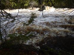
I’ve used this entry a few times in the past so, I can tell the water level is still high but not exceedingly so. Lingering patches of foam hint that the water was higher not so very long ago. The upper reaches of this ‘river’ are more creek like as the constricted banks don’t allow much room for maneuverability. Often, I find the best course of action is to just grab some of the overhanging branches and pull myself ahead. Still, I’m making ever steady progress and soon arrive at the first portage.

There is a clearly obvious grassy landing here on the eastern (right side) shore. I cannot see the entirety of the flume, so I crawl out to check things over. The trail is overgrown but easily followed for its 15-20 rod length, save for the abysmal gauntlet of shiny smooth roots throughout. After assessing that the waterway is free of obstruction, I gingerly shuffle back across. It’s a quick uneventful run-down the small rapids where the Black Pearl picks up a few new minor scrapes along the way before quietly gliding off into a now widening waterway. 
The floodplain near the confluence of the Isabella River is soon encountered. Maps show that there is supposed to be at least one other portage around this area but, I don’t see anything that even resembles a need for getting out, so I contentedly paddle on.
Just below where the last rapids of the Isabella River wash out is the father/son duo ’d met earlier as well as another group of fishermen. I’m not here to fish, just curious about the portage and the campsite on the upstream side. For my solo last spring, in through Island River EP #34, I had the over ambitious goal of day tripping to this end of the river. High flood waters & windy conditions conspired to convince me, quite easily, that would not be a prudent strategy.
So, being it’s still quite early, I feel the tug to revisit these ‘old haunts’ and recall the ghosts of trips gone by. The last time I did this portage has forever been emblazoned in the deep recesses of my memory. It’s not that it was/is the most difficult path, it was just a portage where we did not conserve the energy or motivation to undertake it after an exhilarating, though very long, day. We wrongly surmised the camp near the upstream side of this trail would assuredly be open and thus were forced to undergo one last long agonizing portage upon finding it occupied. To this day, I don’t think I’ve ever been so happy to be finished with a portage?!
The portage is pretty much as I remembered it. Along it’s steadily climbing course, it runs tantalizingly close to the shores of the river, where the swift crashing & bubbling of the ever-cascading water provides a motivational backdrop to get across so as to go back and see what's making all the noise. Since I am without burden this morning, I soon veer off and bushwhack down to the river’s edge where I am treated to a still very full and root beer hued waterway shrouded by some impressive shoreline cedar trees. It’s early, in both the day & season, so the bugs are not an issue while I linger here relishing the sounds and smells of this much anticipated & overdue re-visitation I’ve been graced with today. 
Working my way back on to the portage trail, I encounter a number of large downed trees across the path. Since I’m just hiking, they don’t present too much of an annoyance but, certainly would if I had been bringing the Black Pearl or my pack across. I note that the landing on the upstream side is precariously close to the top of the rapids before cutting off up the spur trail to the campsite.
This is/was the site we had hoped for so long ago. For the first time I finally get to set my eyes on what we bypassed. It’s a nice elevated site with a few excellent grassy tent pads and is not totally burnt out. There’s a panoramic view back up the river that can be contemplated from an ideal sitting rock just up from the fire grate area. The log seating could use an upgrade (and there are a few serviceable replacements already cut near camp), and another huge drawback is that there is currently a huge widow maker leaning in the near vicinity of the best tent pads. I devote some extra time sitting out on the rock knob looking back upstream, fondly reminiscing about the trip through here so long ago.


I’m not sure where, exactly, cartographers would say the Isabella River ends and Bald Eagle Lake begins but, I surmise it to be shortly after passing by north of the currently occupied campsite #1726. I mention it because it is here that an actual bald eagle regally soars just overhead. Instantly an unexpected tingling sensation runs down my back and I become certain of the significance of this event. Let me be clear, I’ve seen countless bald eagles including more than I can count in canoe country but, I will get to the noteworthiness of this particular siting later.
Traveling up the campsite rich eastern seaboard of Bald Eagle, I check out a few of them along the way. The next one, #1727 (in particular) catches my fancy and it is with some regret I press ever northward as getting at least somewhat off the beaten path is a primary factor in choosing camp. With the current high waters, I can paddle very near the otherwise rocky shorelines. There is an ever so gentle breeze that does little to hinder progress but, since the shores are rimmed with lush cedar trees, the intoxicating aromatic indulgence that it proffers up is truly invigorating.
Soon I turn into the tiny bay where the portage landing for Gull Lake is situated. Normally, this is a troublesome boulder garden but, with the high water, I glide right in with nary a scratch. Although a bit damp, there is a roomy staging area here and I take a moment to gather my wits about me before undertaking this notorious portage. 

For me, one of the principal reasons I so enjoy traveling in canoe country is the obvious relation it has with Christian Spirituality by transforming the suffering of deprivation & labor into exultant joy. Let’s face it; most people would NEVER subject themselves and their leisure time to even camping in a tent much less also dragging their food, clothing & shelter across as little as a short easy bug free portage and then exuberantly call it some bizarre version of therapeutic joy. Yet, that’s essentially what anyone who enjoys spending time up here is doing! So, at least in a small way, the transforming of my labors here can help me grow spiritually by preparing & strengthening me for the undoubted struggles that still await me in all other areas on my life.
Of course, all analogies fall short on at least some level and this is a freely chosen endeavor not a random unforeseen event. And, I’m not trying to suggest or trivialize that because I’m doing a tough portage means I (or anyone else) will ‘magically’ be able to adroitly deal with things like an accident, illness or death etc. without plunging into the depths of emotions. But I do believe the type of transformation I detail here certainly promotes spiritual growth and will help to give me a deeper understanding, a sense of fortitude and a better perspective when those type of things do roll around. Most especially when I allow Christ to walk with me through those experiences - small & big.
The trail is initially wet, faint, rocky though easily followed and I soon encounter several nice sized cedars including one substantial upland specimen on the south side of the trail just after the first big climb. These noteworthy cedars aside, much of the portage passes through newly sprouting birch forest where there appears to be no shortage of ruffed grouse. Closer to the creek end there is a neat opening where the trail passes over an immense rock knob before dropping steeply down a rugged path to an undersized, cumbersome landing. There is an impressive nearly sheer granite rise just across the creek.
 x.cfm?fuseaction=photos.display&img=TUSCARORABOREALIS%2D040623%2D185950%2EJPG&name=TripReport">3%2EJPG&name=TripReport">>

Yet again I have no trouble as there is sufficient water for enjoyable landing & navigation. The small tamarack trees are just beginning to needle, and I immediately think ahead to how ablaze in color this creek passage will be in October. There is a small beaver dam & hut very near my next portage. And, the resident beaver has carelessly let some of his chewed sticks drift down stream so, I grab a prized specimen for my ‘pokey’ stick once I reach camp. Also, there is a high ridge just across the waterway. On the top sits a large solitary boulder and for some reason I get the uneasy feeling that it’s somehow watching me! Maybe that last portage took more out of me than I realize? :) 
The landing here is a little mushy but otherwise unremarkable. There is a short climb right off the bat and then some very minor undulation along a boulder laden, burnt over trail. Island campsite #1740 can be seen from this bouldery landing and I set course for that potential new home post haste.  "left" >
Conventional wisdom has it that this is one of the better sites in this burnt-out area. And I must concur that it is indeed just that; as it does not appear to have been ravaged by the fires of the past decade or so. Still, there is just something lacking for me here today and I decide to push on. On the way to the portage to Pietro Lake I also quickly determine that site #1740 is even quite a bit less appealing. However, the large sheer cliffs looming across the bay behind camp intrigue me so I paddle over for a closer, more thorough inspection.
It’s a reasonably easy trek to the top of this granite escarpment as the fires cleared this area out pretty good. I take a few moments to enjoy the incredible vista across Gull Lake before heading back down to continue my journey.


The landing for the portage into Pietro is exceedingly mushy. And, as I proceed down the trail, I encounter a few more well-defined mud holes which are then followed up by the occasional knobby boulder. The path is very level and I’m shocked to see a couple sizable mounds of snow still holding sway near the boulder infested landing on Pietro.
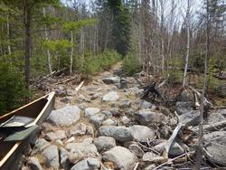
Pietro Lake has had the great misfortune of having had 2 major wildfireS RAVAGE ITS SHORES IN THE PAST GENeration. And to be sure, the regeneration of the surrounding forest is still something of a work in progress. I don’t think too many have recently targeted this lake as a destination which kind of inspires me to spend some time here if possible.
As I begin a clockwise circuit around the lake, the site nearest the portage in from Gull soon comes into view. I paddle up and quickly assess this slightly elevated site as worthy of being my new home for the next couple of days. An exquisite flat area with room for at least a couple tents is tucked back in the shaded corner. An emerging stand of jack pine behind camp and the shoreline has a dozen or so up & coming cedar trees which will really fill in this site beautifully in the coming years. There is a very tiny island just out from camp that adds to the scenery and an easily accessible massive rock rise behind camp that provides an overlook of the lake but, with the trees growing this will likely soon be minimized. There is an active beaver lodge in the small back bay and some loons are soon checking me out as well. This site will only get better with time if the trees are left alone and I’m happy to call it home for the next couple of nights.
 "left" >
//photos.bwca.com/thumbnails/TUSCARORABOREALIS-040623-125543.JPG" align="left" >
There isn’t much for firewood in & around camp so, taking full advantage of camping in a recent burn zone, I paddle a very short distance NE up the shoreline and pull out several of the still standing, dried out skeletal remains of several old cedar & spruce trees. Soon, I am putting my recently acquired beaver stick to its intended use as I savor the flickering, ambient glow of a warMING FIRE DURING A RAPIDLY COOLING evening under an elegantly starlit sky.
~Snake River, Isabella River, Bald Eagle Lake, Gull Lake, Pietro Lake


Amy has promised that she'll do the rest of the border route with me some time, so I'm looking forward to that. Maybe some time in the future she and I can make the whole trip, too. Although I've also discovered I'd much rather paddle through a winding river or a bunch of small lakes than across the big lakes. I've found a lot of new places I want to take her, which was also another part of making the trip.
Anyway, thanks for reading this and I hope you got some enjoyment out of it! I look forward to seeing you out on the water.
Greg