|

 Forum Sponsor

Author
Text
")

05/09/2018 02:32PM
Has anyone ever had one map encompass their entire route? My wife and I look at every map possible and would to find a single map that actually is the route we want to take. Why must every map be centered on multiple entry points and makes it where u need to buy multiple ones to get anywhere, or make your own with screenshots/cropping/editing
this is my rant, and it is over. lol good day
this is my rant, and it is over. lol good day
Reply
Reply with Quote
Print
Top
Bottom
Previous
Next

05/09/2018 03:37PM
Some people print custom maps.
Otherwise the Voyageur series may have the best balance between detail needed for navigation and large areas in one map.
For us, we just carry a bunch of maps in a map case and so it isn't like we have a bunch of loose things. For a day of traveling, we can generally set up the maps so the two sides of the map case show us everything we need. For a really long day, we might have to turn a map over. We cope.

05/09/2018 04:01PM
Is that really a problem? I always carry multiple maps - usually a couple brands - in case of a route taking me right down the edge of two different maps or for double-checking a portage location, etc.. Is it an inconvenience? Whatever... it is what it is and we deal with it.
Do you fold your maps and have them in a clear carry case attached to a pack or a thwart as you travel?

Here are all of the McKenzie maps that we used to cross Quetico laid out in our campsite on Kawnipi.
Do you fold your maps and have them in a clear carry case attached to a pack or a thwart as you travel?
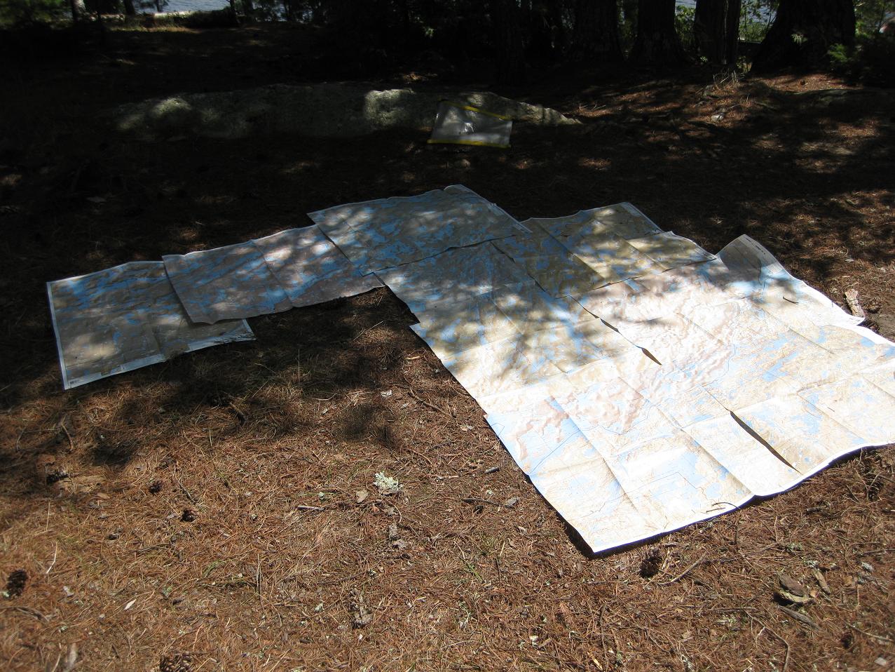
Here are all of the McKenzie maps that we used to cross Quetico laid out in our campsite on Kawnipi.
"Keep close to Nature's heart, yourself; and break clear away, once in a while, and climb a mountain or spend a week in the woods. Wash your spirit clean." ~ John Muir
05/09/2018 04:13PM
Yes, in 2016 our trip on the Granite River was completely on one McKenzie map. I think maybe it was #5? Doesn't bother me having to buy multiple maps to cover a trip. It's a grid system and the grid has to start somewhere.
When a man is part of his canoe, he is part of all that canoes have ever known. - Sigurd F. Olson, "The Singing Wilderness"
05/09/2018 05:19PM
Some outfitters have custom maps made for specific areas or routes. Sawbill Outfitters for example has a custom map that covers multiple routes and loops in that area. Inquire at an outfitter that services the area where you are going if they have custom maps available.
05/09/2018 05:42PM
Yes: If the base camp will not be left often or if I only need a map which is for an area out of my experience of travel on a day trip.
Also once when on the border route and I thought no problem. Was difficult due to very small detail which the map by necessity had to use. It can be done, but not recommended for what other maps I own give the necessary details i would prefer.
Also once when on the border route and I thought no problem. Was difficult due to very small detail which the map by necessity had to use. It can be done, but not recommended for what other maps I own give the necessary details i would prefer.
the greatest come backs are reserved for those with the greatest deficits.
05/09/2018 07:56PM
there are many trips to be made using a Fisher F32.
Mckenzie #2 works for the johnson falls loop provided you don't plan to go east on pine lake.
fisher 13 covers gunflint to rose and exit through duncan to west bearksin (or vv)
mckenzie 4A covers cross bay/ham lake to poplar (or vv)
fisher F12 covers cross bay/ham lake/snipe loop.
and, as mirth mentioned, Mckenzie #5 covers the granite river route leaving gunflint lake traveling north to sag and exiting at the sag public landing.
you don't mention what kind of trip you want to take, length of time or mileage so these maps are suggestions of trips that could be day trips or trips of many nights!
")
05/09/2018 08:33PM
It has to do with the map scale. Too small of a scale and you have trouble seeing the detail. Too large and you need multiple maps. Most of the popular map makers try to center the maps in the most popular areas using a easily read scale.
Or they like to sell you lots of maps.
Or they like to sell you lots of maps.
"So many lakes, so little time." WWJD
05/09/2018 09:59PM
A wise paddler long ago advised taking enough maps to cover areas adjacent to your route in case:
1. You stray from your route (never happens) and you need to figure out where you are.
2. You want to take some side trips to see pictographs or waterfalls.
3. Fire or blowdowns block your planned route
4. You need to bail out because of illness or injury or bad weather and need an alternate exit.
Map reading for some of us is as fulfilling as fire building or tarp rigging might be for others.
OtherBob - lots of Bobs on this board
05/09/2018 10:53PM
I love maps and am happy to purchase them. Given the price of canoe, paddles, life jackets, fishing gear, etc. etc. etc., the map represents an estimated .05% of the total cost of a trip. That's not enough for me to worry about.
05/10/2018 01:09AM
I agree about cartography in general. The map producers establish the standard map size & scale then arrange the map sheet outline as efficiently as possible on the entire mapping area (l.e Quetico Park & BWCA). I always buy two (2) sets of maps for our trip area with extra coverage for the reasons mentioned and this years route falls right in the division line on McKenzie Maps so I ended up buying $56 in maps and I had some from previous trips. If one map covered our entire trip the scale would make it useless or it would be the size of a king size bed. It’s ok, I spend hours marking them up pre-trip. Information and knowledge is priceless once your on your trip. There is nobody to ask and if someone happens by they probably don’t know either. We do take a large map case that stays in the pack with all but the current map that is in smaller map cases bow and stern. BTW, we also take a garmin gps. Different story but, very useful.
05/10/2018 08:13AM
You could pick a map and design your route around it (or basecamp at an entry), but I prefer to choose a route and get whatever maps I need at a useable scale. Voyageur Maps are the largest and cover it in 10 maps. You could get the Nat Geo maps and probably do it, but I'd prefer a more useable scale for a trip, although some people have claimed to have done it.
05/10/2018 11:09AM
Savage Voyageur: "It has to do with the map scale. Too small of a scale and you have trouble seeing the detail. Too large and you need multiple maps. Most of the popular map makers try to center the maps in the most popular areas using a easily read scale.
Or they like to sell you lots of maps. "
exactly.
We also make our own maps, usually buy at least one as well, save digital screen shots of multiple depth charts,, maps at various zooms etc etc..
but ...it would be swell to have the maps centered on 1 entry point at a time. taking out multiple maps for one portage trek is tedious, albeit i study maps so much, for fun..anyways
05/10/2018 11:22AM
Here is a great, FREE resource that came out a while back. I use this to print out backup quads, or quads of surrounding areas. Does not have campsites, so you can either compare to the bwca.com maps and fill them in on your own, or just have for navigation/backup.
National Geographic Maps FREE
National Geographic Maps FREE
05/10/2018 11:50AM
Fisher F-16 covers some great routes around EP14 (LIS), EP16 (moose river), and EP19 (Stuart river). There are several great loop routes (and out and back) that you could pull off with that map alone. EPs are at the very bottom of the map and the CA-US border is at the top!
“When one finally arrives at the point where schedules are forgotton and becomes immerised in ancient rhythms, one begins to live. “ -Sigurd Olson
05/10/2018 05:17PM
carmike: "I love maps and am happy to purchase them. Given the price of canoe, paddles, life jackets, fishing gear, etc. etc. etc., the map represents an estimated .05% of the total cost of a trip. That's not enough for me to worry about. "
What carmike said.
"Keep close to Nature's heart, yourself; and break clear away, once in a while, and climb a mountain or spend a week in the woods. Wash your spirit clean." ~ John Muir
05/11/2018 01:26PM
This year, for our first trip, I'm going to try stashing a Voyageur map in my bag, and printing off 8.5 x 11 maps from Caltopo for the route. Each day of the route will fit on one or two sheets of paper. I've lined them up so I can change pages at a portage.
Will it work well? IDK. I think it will.
In theory, I could print all the route on one page at a high scalw, but somewhere around 1:42,240 or 1:50,000 scale seems better.
Will it work well? IDK. I think it will.
In theory, I could print all the route on one page at a high scalw, but somewhere around 1:42,240 or 1:50,000 scale seems better.
Reply
Reply with Quote
Print
Top
Bottom
Previous
Next

Subscribe to Thread
Become a member of the bwca.com community to subscribe to thread and get email updates when new posts are added. Sign up Here
 Search BWCA.com
 Donate