|
 Boundary Waters Quetico ForumQuetico ForumWhere are these portages?
|
 Forum Sponsor

Author
Text
")

05/31/2018 11:52AM
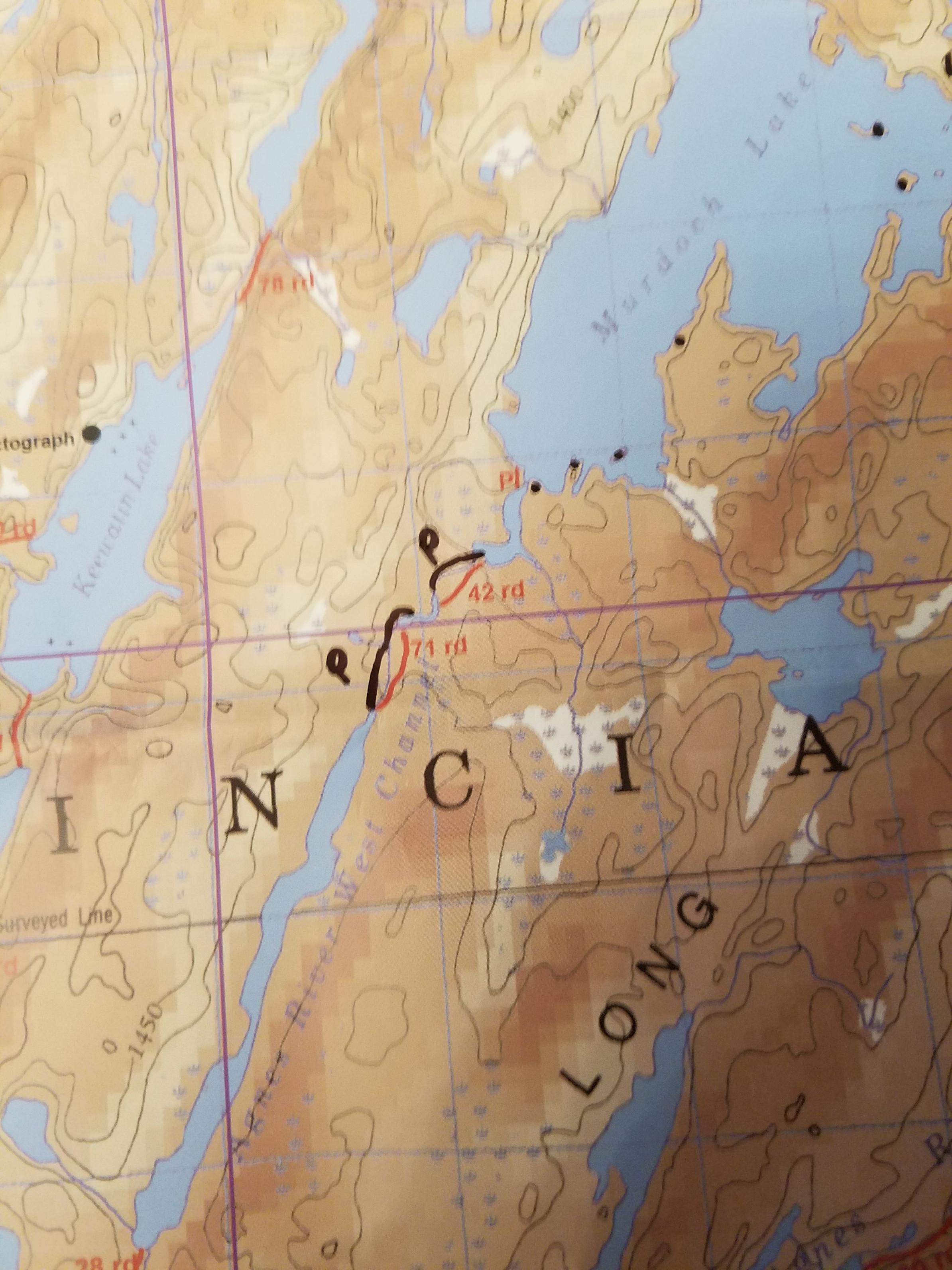
I need some help finding the exact location of a couple of portages. The location of some portages on my McKenzie maps don't match a popular canoe mapping website that I'm not allowed to mention on here (I will reference this site as "PP"). I've attached a couple of pictures to show where they differ. I drew black lines for where PP says the portages are located, and the red lines are where McKenzie says they are located.
In particular:
1) Noon Lake to Summer Lake portage is shown much further North on PP than McKenzie. Which is correct?
2) Summer Lake to Sultry Lake portage is shown on the left (West) of a creek on PP, rather than the right of it like on McKenzie. Which is correct?
3) Sultry Lake to Silence Lake portage is shown to the right (East) of a creek on PP, rather than through the center of it like on McKenzie. Which is correct?
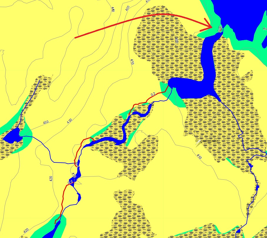
4) Agnes River West Channel to Murdock Lake portage is shown as 3 portages to the left (West) of a creek on PP, but they're shown to the right (East) on my McKenzie Maps. To further complicate this one, the Ontario Parks Portage Maintenance map shows this as actually being 4 portages. Which is correct?
Also, PP shows some pictographs on Agnes just North of a tiny island, whereas McKenzie shows some just South of the island. Are there two sets of pictographs, or are the maps just differing again?
If you've been along these routes, I appreciate your input. I've been to Quetico a few times, but this will be my first solo trip so I want to have as accurate of maps as possible. Thank you!


In particular:
1) Noon Lake to Summer Lake portage is shown much further North on PP than McKenzie. Which is correct?
2) Summer Lake to Sultry Lake portage is shown on the left (West) of a creek on PP, rather than the right of it like on McKenzie. Which is correct?
3) Sultry Lake to Silence Lake portage is shown to the right (East) of a creek on PP, rather than through the center of it like on McKenzie. Which is correct?
4) Agnes River West Channel to Murdock Lake portage is shown as 3 portages to the left (West) of a creek on PP, but they're shown to the right (East) on my McKenzie Maps. To further complicate this one, the Ontario Parks Portage Maintenance map shows this as actually being 4 portages. Which is correct?
Also, PP shows some pictographs on Agnes just North of a tiny island, whereas McKenzie shows some just South of the island. Are there two sets of pictographs, or are the maps just differing again?
If you've been along these routes, I appreciate your input. I've been to Quetico a few times, but this will be my first solo trip so I want to have as accurate of maps as possible. Thank you!


Reply
Reply with Quote
Print
Top
Bottom
Previous
Next


05/31/2018 02:23PM
Get a Chrismar Quetico map at Prairie Portage or Piragis Northwoods Co. The entire park in one roadmap sized waterproof sheet (like a roadmap it's folded). Portage locations are much more accurate than McKenzie or Fisher maps.
Don't leave home without it. Chrismar Map
Don't leave home without it. Chrismar Map
Nobody exists on purpose, nobody belongs anywhere, everybody’s going to die.
05/31/2018 03:41PM
The portages are as marked on the red map lines, not the marker pen. Into Silence from the south, the portage starts on the right, the east, then fords the shallow steam, then follows the west edge of a beaver bog, which can be easy or mucky, depending on the season, and finally has a final pleasant stroll through the woods to Silence.
The Agnes River to Murdock is on the west side, There are several landings on the east to fool you, but don't fall for them or you will double your time climbing over trees and muck. I speak from experience.
Actually, if you do not mind getting wet, you can walk and hang onto your canoe as you travel the small rapids into Kawnipi.
"I shall return" General Douglas McArthur
05/31/2018 04:06PM
It's been 15 years, but we camped at the campsite on Sultry right by the portage to Silence. I can't tell you which side the portage trail is on, but I can tell you that it's quite visible.
"Keep close to Nature's heart, yourself; and break clear away, once in a while, and climb a mountain or spend a week in the woods. Wash your spirit clean." ~ John Muir
05/31/2018 08:10PM
As Banks said, the Chismar map is by far and away your best resource when in doubt. I always carry a Fisher and use it to navigate but keep the Chrismar in my map case and check it anytime I have any question of portage location.
06/01/2018 06:36AM
Banksiana: "Get a Chrismar Quetico map at Prairie Portage or Piragis Northwoods Co. The entire park in one roadmap sized waterproof sheet (like a roadmap it's folded). Portage locations are much more accurate than McKenzie or Fisher maps.
Don't leave home without it. "
+1

06/01/2018 08:13AM
carmike: "Banksiana: "Get a Chrismar Quetico map at Prairie Portage or Piragis Northwoods Co. The entire park in one roadmap sized waterproof sheet (like a roadmap it's folded). Portage locations are much more accurate than McKenzie or Fisher maps.
Don't leave home without it. "
+1 "
+2
Here is a place to order it: Chrismar
"It is more important to live for the possibilities that lie ahead than to die in despair over what has been lost." -Barry Lopez
06/01/2018 10:04AM
billconner: "I have found on Mackenzie maps, to often all in red printing - like portages and pictos - is mis registered. Definitely have a current Chrismar. "
+1. As bill mentions above, The Mackenzies can be off at times with regards to portage locations. PP can have more accurate info but the only way to really locate them and mark them is to do as RC has stated which is map them out with your GPS as you go.
Either set of information will get you "in the neighborhood" which is a start.
"It is hard to fail, but it is worse never to have tried to succeed.”
Reply
Reply with Quote
Print
Top
Bottom
Previous
Next

Subscribe to Thread
Become a member of the bwca.com community to subscribe to thread and get email updates when new posts are added. Sign up Here
Community Links
 Search BWCA.com
 Donate
 Featured Sponsor
