|
 Boundary Waters Quetico ForumTrip Planning ForumWhat is the Pagami Creek burned area like these days?
|
 Forum Sponsor

Author
Text
")
02/25/2019 02:59PM
My group is starting to plan a trip, and we are thinking of entering at Lake One and heading to Insula. That would bring us right through the burned area . It's been almost 8 years, and seeing some pics people have taken, it seems the forest is recovering.
We are thinking of going there specifically because it's an opportunity to see the forest in an ecological state much different than usual. Is it worth going that way for that reason? If we did go through there, is there anything different we should expect?
Thanks
We are thinking of going there specifically because it's an opportunity to see the forest in an ecological state much different than usual. Is it worth going that way for that reason? If we did go through there, is there anything different we should expect?
Thanks
Reply
Reply with Quote
Print
Top
Bottom
Previous
Next


02/25/2019 03:09PM
I've traveled and fished in the areas of Bog lake and Isabella Lake. It's definitely interesting to see how the forest is growing back. With that said, I would not want to camp at a site that was affected by the fire. Most campsites that were affected by the fire lack any shade and trees to hang a tarp. I would make sure to find a site unaffected by the fire and then do some day trips through the burn area.
02/25/2019 04:37PM
LakeLobster: "My group is starting to plan a trip, and we are thinking of entering at Lake One and heading to Insula. That would bring us right through the burned area . It's been almost 8 years, and seeing some pics people have taken, it seems the forest is recovering.
We are thinking of going there specifically because it's an opportunity to see the forest in an ecological state much different than usual. Is it worth going that way for that reason? If we did go through there, is there anything different we should expect?
Thanks
"
We did this exact trip last August. I've been meaning to put together a trip report with pictures. The quick answer is it is coming back slowly. I agree that I would not want to camp on a site in the burn area. There wouldn't be much shade and I would imagine the firewood pickings would be slim still.
A few photos:
Lake 4 to Hudson Portage:
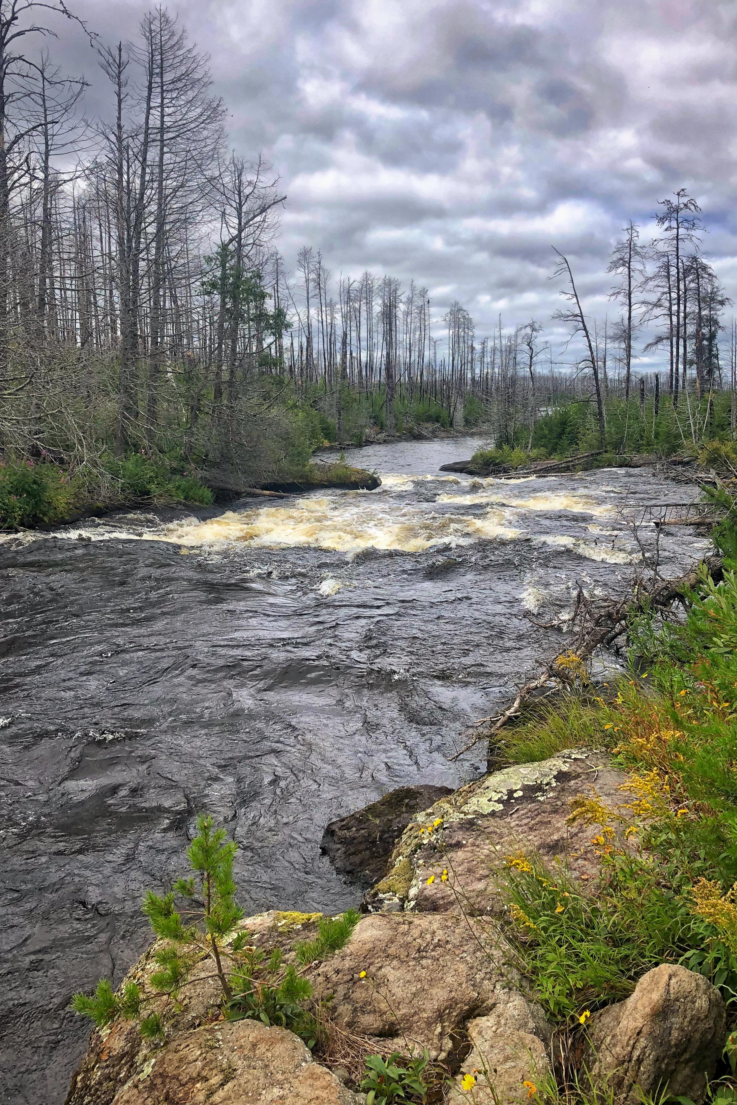
Hudson:


Hudson/Insula Portage:

Insula at the edge of the burn:

Northern Insula (unburned):


02/25/2019 06:34PM
There are some sites in southern insula that somehow were protected and might be interesting. I saw campers in a couple.
In general, having been through two different parts of it in past few years, noreason not to go. And great berries!
In general, having been through two different parts of it in past few years, noreason not to go. And great berries!
02/26/2019 08:06AM
sylvesterii: "LakeLobster: "My group is starting to plan a trip, and we are thinking of entering at Lake One and heading to Insula. That would bring us right through the burned area . It's been almost 8 years, and seeing some pics people have taken, it seems the forest is recovering.
We are thinking of going there specifically because it's an opportunity to see the forest in an ecological state much different than usual. Is it worth going that way for that reason? If we did go through there, is there anything different we should expect?
Thanks
"
We did this exact trip last August. I've been meaning to put together a trip report with pictures. The quick answer is it is coming back slowly. I agree that I would not want to camp on a site in the burn area. There wouldn't be much shade and I would imagine the firewood pickings would be slim still.
A few photos:
Lake 4 to Hudson Portage:
Hudson:


Hudson/Insula Portage:

Insula at the edge of the burn:

Northern Insula (unburned):

"
We also did this trip, last July - with kids. We didn't find a campsite until late, wanting to push through the burn area. We were lucky to get the beach campsite to the east of Williamson Island. Backup plan was to head north on Hudson before the portage into Insula if we were too tired, and there were some decent campsites at the end of the number chain, but we were stubborn and wanted to make it to Insula in one day. That last portage into Insula wore us all out, and we were seriously dragging across Insula. I was glad I downloaded Huntstand App on my phone, in airplane mode you can follow a route ahead of time, because I was mentally and physically exhausted and the southern side of Insula can get you turned around easily. Insula was a blast and we thoroughly enjoyed it. You can check out my trip report HERE.
02/26/2019 09:13AM
If you want another option for that burn area you can start at EP 37 Kawishiwi Lake and go north from there. The entry lake itself was not burned, but the next 2 were for the most part (still at least one decent campsite between the two if not more) and then you're back out of the burn area once you're into Polly. A few shorelines of Polly were burned so it was right on the edge so you could see both burned and un-burned from that lake.
You can easily get to Polly on Day 1 if you want to avoid trying to camp in the burn area, but you'll paddle through it and can explore on day trips and also see it on the way out.
You can easily get to Polly on Day 1 if you want to avoid trying to camp in the burn area, but you'll paddle through it and can explore on day trips and also see it on the way out.
02/27/2019 01:06PM
I only came here to say that after 7 seasons since the fire the blueberry habitat must be about perfect. Billconner made mention to that. If I were thinking of an August trip I'd consider this and other recent burn areas because of this - and my group loves fresh berries, especially on pancake days.
Finding shade at/in/near campsites might be challenging as others have said. Internet satellite imagery has been updated since the fire, so you can get an idea about what any given campsite might have to offer if you're good at cross referencing BWCA maps against the satellite.
Finding shade at/in/near campsites might be challenging as others have said. Internet satellite imagery has been updated since the fire, so you can get an idea about what any given campsite might have to offer if you're good at cross referencing BWCA maps against the satellite.
When a man is part of his canoe, he is part of all that canoes have ever known. - Sigurd F. Olson, "The Singing Wilderness"
")
03/01/2019 07:23PM
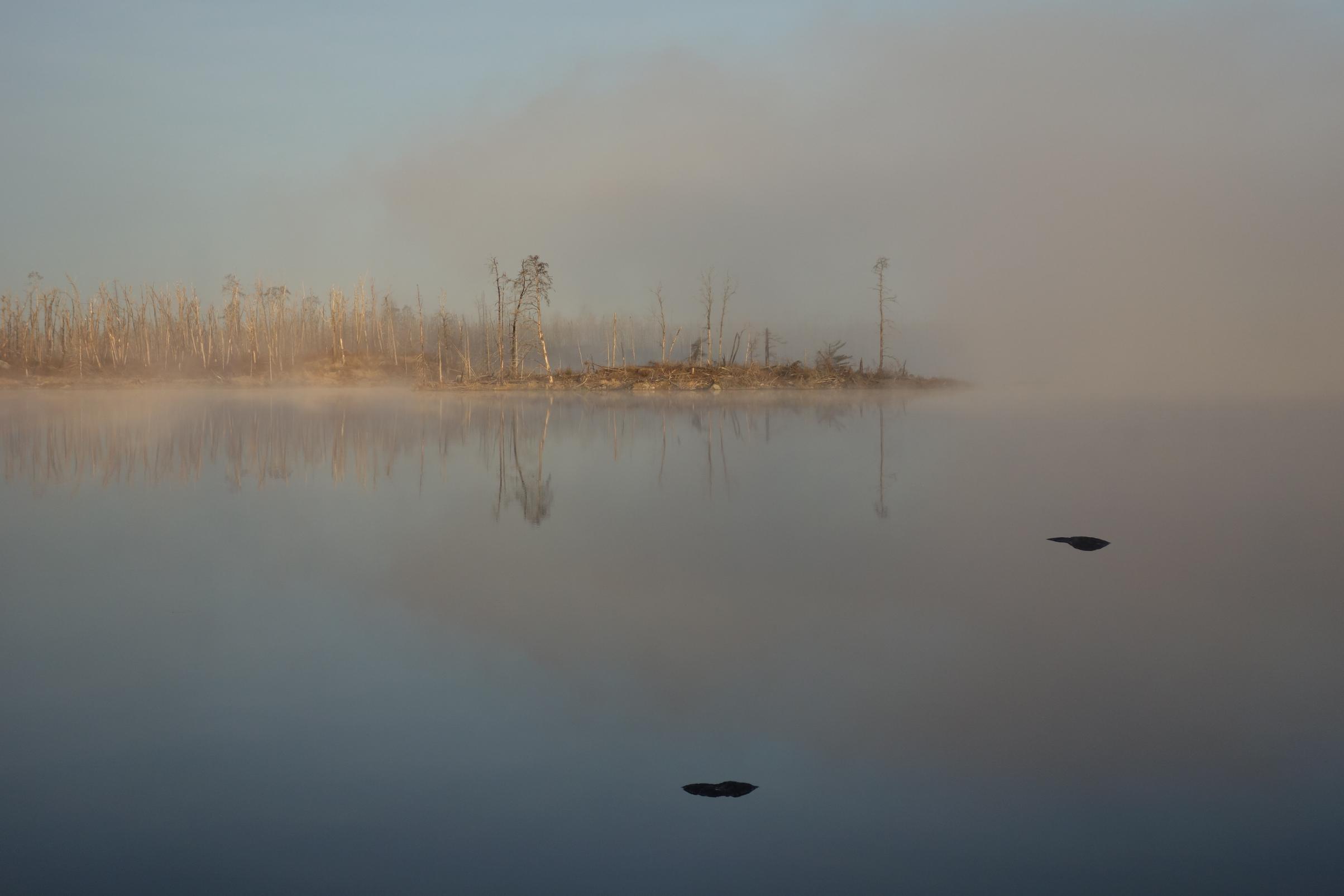
I went into insula in September. The pics others have posted sort of do it justice, but being surrounded 360 degrees by the burn is a little bit different. yes, the forest is coming back, with 6' tall bushes and 8' tall jack pine so far. As you can see, the burned timber are still standing and are the most prominent feature of the landscape. On a more positive note/tone, you do see waaaayyy more granite outcroppings. Being from southern MN where we don't have that, it is the only positive I took from the experience.
I would not want to take a trip to camp in the burn...it would not seem like it would meet the point of a canoe wilderness trip. While there are some unburned trees immediately adjacent to the campsites, which largely did not burn probably due to limited pre-fire undergrowth and pre-fire clearing by campers, your view from a campsite is to stare at the burn area. Travelling through the burn area for 3-4 hours on the way in was more than enough for me to experience it. On the way out I was sick of looking at the desolation.
I would not want to take a trip to camp in the burn...it would not seem like it would meet the point of a canoe wilderness trip. While there are some unburned trees immediately adjacent to the campsites, which largely did not burn probably due to limited pre-fire undergrowth and pre-fire clearing by campers, your view from a campsite is to stare at the burn area. Travelling through the burn area for 3-4 hours on the way in was more than enough for me to experience it. On the way out I was sick of looking at the desolation.
03/14/2019 10:20AM
sylvesterii: "LakeLobster: "My group is starting to plan a trip, and we are thinking of entering at Lake One and heading to Insula. That would bring us right through the burned area . It's been almost 8 years, and seeing some pics people have taken, it seems the forest is recovering.
We are thinking of going there specifically because it's an opportunity to see the forest in an ecological state much different than usual. Is it worth going that way for that reason? If we did go through there, is there anything different we should expect?
Thanks
"
We did this exact trip last August. I've been meaning to put together a trip report with pictures. The quick answer is it is coming back slowly. I agree that I would not want to camp on a site in the burn area. There wouldn't be much shade and I would imagine the firewood pickings would be slim still.
A few photos:
Lake 4 to Hudson Portage:
Hudson:
Hudson/Insula Portage:
Insula at the edge of the burn:
Northern Insula (unburned):
"
Thanks for the photos, provides a great feel for the area. Please do a trip report.
03/14/2019 01:26PM
sylvesterii: "LakeLobster: "My group is starting to plan a trip, and we are thinking of entering at Lake One and heading to Insula. That would bring us right through the burned area . It's been almost 8 years, and seeing some pics people have taken, it seems the forest is recovering.
We are thinking of going there specifically because it's an opportunity to see the forest in an ecological state much different than usual. Is it worth going that way for that reason? If we did go through there, is there anything different we should expect?
Thanks
"
We did this exact trip last August. I've been meaning to put together a trip report with pictures. The quick answer is it is coming back slowly. I agree that I would not want to camp on a site in the burn area. There wouldn't be much shade and I would imagine the firewood pickings would be slim still.
A few photos:
Lake 4 to Hudson Portage:
Hudson:
Hudson/Insula Portage:
Insula at the edge of the burn:
Northern Insula (unburned):
"
Amazing photos. What kind of camera did you use?
03/17/2019 09:35AM
cyclones30: "If you want another option for that burn area you can start at EP 37 Kawishiwi Lake and go north from there. The entry lake itself was not burned, but the next 2 were for the most part (still at least one decent campsite between the two if not more) and then you're back out of the burn area once you're into Polly. A few shorelines of Polly were burned so it was right on the edge so you could see both burned and un-burned from that lake.
You can easily get to Polly on Day 1 if you want to avoid trying to camp in the burn area, but you'll paddle through it and can explore on day trips and also see it on the way out. "
Sunrise mid-lake on the east side of Kawasachong. Campsite is nothing special, but dawn on the edge of a burn area is. The site is on a small point that was spared by the fire. Lots of evidence of moose in and around the site though we did not see the animals themselves. This is a good late in, early out option.
I'm not locked in here with you, you're locked in here with me
03/18/2019 08:54AM
ManAndDog,
Most of the photos were just with my iPhone 7 Plus. I did also bring my Fuji X-E2s, and got some great shots with that too. While in the canoe, it is just easier to grab the iPhone, since it is always in my pocket vs. inside a waterproof bag, inside my backpack, which was lashed into the canoe.
This is definitely for another post, but the Fuji X system really is a fantastic balance of size/weight/quality for the BWCA. I can carry the camera plus all of my lenses for about the same weight as my old Nikon DSLR plus my 300mm f/4 with equal image quality.
The iPhone can hold up pretty well for photos being viewed online or on your phone (and some smaller prints) but for anything that you would want to print larger than an 8x10 the quality difference would be noticeable.
03/18/2019 11:08AM
LakeLobster: "Thanks everyone for the info. We decided to go on a route near South Kawishiwi river and Gabbro lake, that way we can day trip into the burned area but don't need to camp in it. "
As you paddle Gabbro, notice the north shore re-growth from a 1996 burn. You might not know it had burned had I not told you.
I visit the Pagami burn twice a year and am absolutely amazed at the speed of growth of the forest. There are plenty of aspen over 15 feet tall with birch not far behind. Jack Pine and white pine are plentiful. It's a giant science classroom.
Tom
03/18/2019 12:49PM
tumblehome: "LakeLobster: "Thanks everyone for the info. We decided to go on a route near South Kawishiwi river and Gabbro lake, that way we can day trip into the burned area but don't need to camp in it. "
As you paddle Gabbro, notice the north shore re-growth from a 1996 burn. You might not know it had burned had I not told you.
I visit the Pagami burn twice a year and am absolutely amazed at the speed of growth of the forest. There are plenty of aspen over 15 feet tall with birch not far behind. Jack Pine and white pine are plentiful. It's a giant science classroom.
Tom"
I know the jack pine came back in gang busters, I hope your right on the White Pine.
03/19/2019 03:35PM
I'll have to check that out. I did also notice the Turtle Creek burned area from 2006 borders the Pagami burned area, so there will be a few examples of points in the recovery process that I am interested in checking out.
tumblehome: "LakeLobster: "Thanks everyone for the info. We decided to go on a route near South Kawishiwi river and Gabbro lake, that way we can day trip into the burned area but don't need to camp in it. "
As you paddle Gabbro, notice the north shore re-growth from a 1996 burn. You might not know it had burned had I not told you.
I visit the Pagami burn twice a year and am absolutely amazed at the speed of growth of the forest. There are plenty of aspen over 15 feet tall with birch not far behind. Jack Pine and white pine are plentiful. It's a giant science classroom.
Tom"
Reply
Reply with Quote
Print
Top
Bottom
Previous
Next

Subscribe to Thread
Become a member of the bwca.com community to subscribe to thread and get email updates when new posts are added. Sign up Here
Community Links
 Search BWCA.com
 Donate
 Featured Sponsor
