|
 Boundary Waters Quetico ForumListening Point - General Discussion Memories of the Eastern Loop of the PowWow
|
 Forum Sponsor

Author
Text
")

12/17/2019 06:30PM
There has been a fair deal of discussion about the Pow Wow trail in recent years as so many wonderful volunteers have gradually reclaimed it from Pagami. I was recently putting away some summer and fall gear and happened upon some early 1990s maps I picked up when one of the Gander Mt's went under. This map reminded me of an old trail of the BWCA as it showed a southern portion of the old "eastern loop" of the Pow Wow trail. I have heard rumors and stories about it, but I don't know that much more than the route it used to follow (thanks to the USGS map online.) I unfortunately haven't gotten the chance to hike the current Pow Wow (it's on the list,) and, honestly, I wasn't alive when they stopped maintaining the Eastern loop. I do know they stopped maintaining it to focus on the Western loop (?) and then, after decades of no official maintenance, Pagami erased a good piece of it. Staring at the map, it seems only the sections from where it entered the BWCA to the Parent River and the section from Peerless to Whittler escaped Pagami. Looking at the old maps, it loops like there was a strange connection trail between the two loops that followed Arrow Creek past Calamity Lake that appears to be very marshy with some strange topo along the way.
So, my question is this, does anyone have an fond memories from the Eastern loop? From what I have heard, the Western loop was more scenic (thus the reason it was maintained?) I know that whole part of the BW is full of old logging roads and trails, I figure some of you probably played around on the Eastern loop at some point? Thanks for any stories you have, I would love to hear them.
So, my question is this, does anyone have an fond memories from the Eastern loop? From what I have heard, the Western loop was more scenic (thus the reason it was maintained?) I know that whole part of the BW is full of old logging roads and trails, I figure some of you probably played around on the Eastern loop at some point? Thanks for any stories you have, I would love to hear them.
12/17/2019 07:09PM
Could you post a picture of your map? I never did the eastern loop, but I did day trips on parts of it hunting.
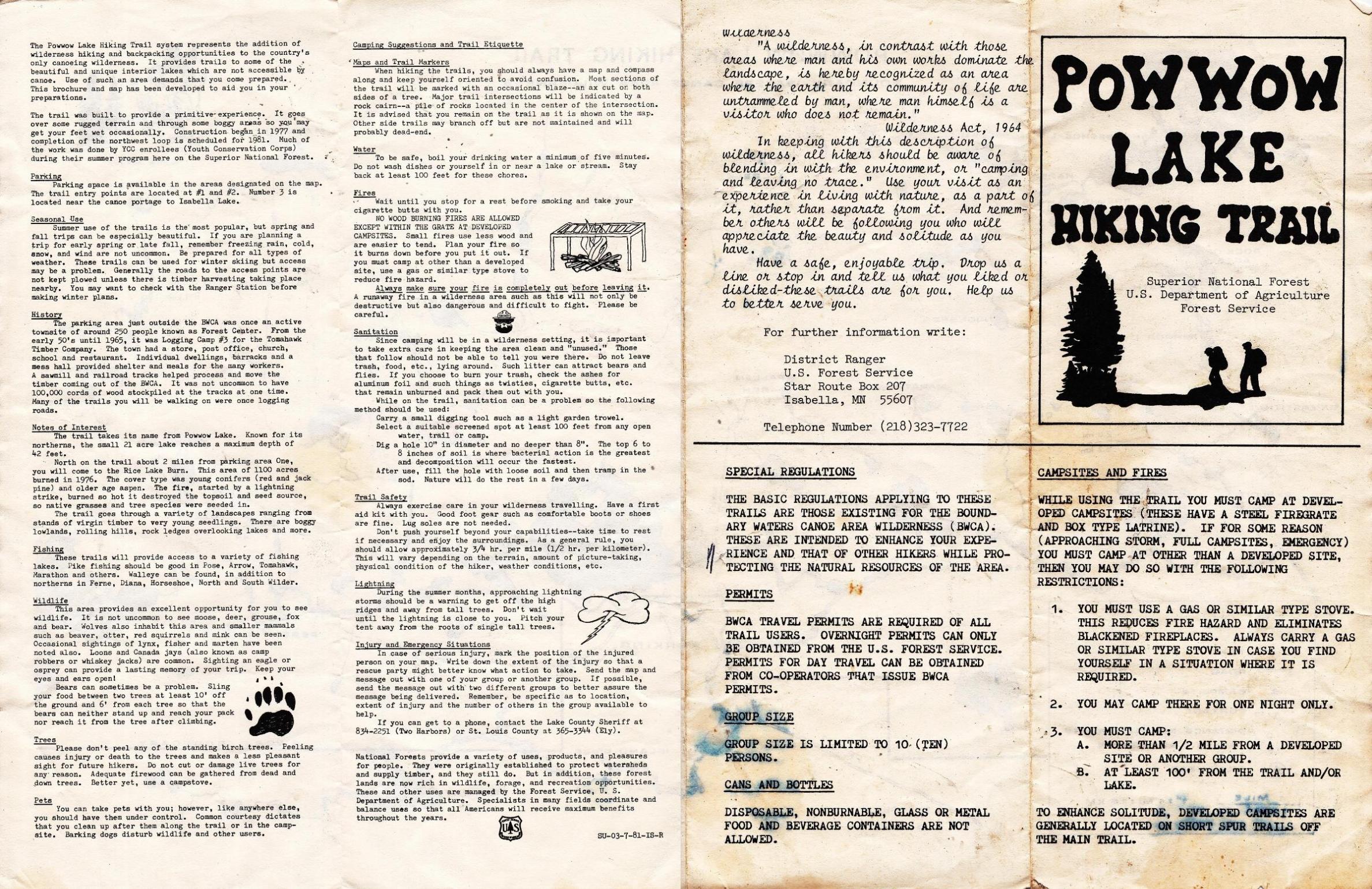
These pictures were posted on the jackpinejim thread by Tomahawk.

 You might find some good info in the jackpinejim thread.
These pictures were posted on the jackpinejim thread by Tomahawk.

 You might find some good info in the jackpinejim thread.
Raised by wolves!

")

12/19/2019 10:32AM
rtallent: "If I recall correctly, from canoeing the Perent River from Perent Lake over to Isabella Lake, probably back in the 90's, there was a footbridge over a narrow part of the river... probably long gone, now?"
Correct and a campsite right there. I would backpack in and camp there,and than grouse hunt from there.
12/19/2019 08:12PM
Thanks for the information everyone. I spent some serious time toying around with air photos and maps; here is what I found. I would say that someone (a hunter?) is for sure maintaining the stretch from the entry point to the Parent river. It looks WAY too clear on the airphoto to be left to its own devices. The bridge you mentioned is for sure gone, but the campsite still shows up on the maps (though it might be closed.) On the air photo, I was able to trace the entire length of the Eastern loop including the connection trail through to the Western loop via the Calamity region. Now, it is some of the most foreboding terrain to cross right now with the burn zone, but with a solid gps and a ton of time I would almost say someone could still find their way. I would even reckon a couple of the unburned sites may still be around (Fungus Lake for sure, Tomahawk is likely, and the grates at most of the burned ones if you are determined enough.) Since they are in the PMA, they are "closed" and would take a special permit. I can't imagine how tough overland through the Eastern loop is, but fun idea all the same.
12/20/2019 08:06AM
TreeBear: "On the air photo, I was able to trace the entire length of the Eastern loop including the connection trail through to the Western loop via the Calamity region. Now, it is some of the most foreboding terrain to cross right now with the burn zone, but with a solid gps and a ton of time I would almost say someone could still find their way. I would even reckon a couple of the unburned sites may still be around (Fungus Lake for sure, Tomahawk is likely, and the grates at most of the burned ones if you are determined enough.) Since they are in the PMA, they are "closed" and would take a special permit. I can't imagine how tough overland through the Eastern loop is, but fun idea all the same."
We hunted in the fire zone adjacent to Isabella in October. Be sure to have an orthopedic surgeon and a bone saw with you when you go. And a team of burros, not mules, to haul enough food for your trek - you’re gonna need it. :-)
12/20/2019 09:39AM
I soloed the eastern loop of the Pow Wow back in Oct 1982 as a first year BSU student. Old logging roads, trail segments, partially frozen beaver ponds flooding trail, and regenerating forest. I wished I had brought my shotgun. Lots of grouse.
“Growth for the sake of growth is the ideology of the cancer cell.” -Edward Abbey
12/20/2019 09:44AM
arctic: "I soloed the eastern loop of the Pow Wow back in Oct 1982 as a first year BSU student. Old logging roads, trail segments, partially frozen beaver ponds flooding trail, and regenerating forest. I wished I had brought my shotgun. Lots of grouse."
The good old days,grouse everywhere up there. At times tho the POW Wow trail also had hunters all over,at least the first couple of miles,than they thinned out. At daybreak cars in numbers headed for the Pow Wow trails.
Use to fish Ferne lake and on the north end of Ferne the road was real wide and a red pine plantation. Than road came to T as you went north. You could go east or west,but the trail slowly faded away in the late 1980's.
12/20/2019 07:02PM
There is a great book called "Lost in the Wild" - Danger and Survival in the North Woods. Written by Cary Griffith, the book chronicles two different stories of survival in alternating chapters. In the wilderness, one false step can make the difference between a delightful respite and a brush with death. On a beautiful summer afternoon in 1998, Dan Stephens, a 22-year-old canoeist, was leading a trip deep into Ontario’s Quetico Provincial Park. He stepped into a gap among cedar trees to look for the next portage—and did not return. More than four hours later, Dan awakened from a fall with a lump on his head and stumbled deeper into the woods, confused.
The Pow-Wow story...
Three years later, Jason Rasmussen, a third-year medical student who loved the forest’s solitude, walked alone into the Boundary Waters Canoe Area Wilderness on a crisp fall day. After a two-day trek into a remote area of the woods, he stepped away from his campsite and made a series of seemingly trivial mistakes that left him separated from his supplies, wet, and lost, as cold darkness fell. Enduring days without food or shelter, these men faced the full harsh force of wilderness, the place that they had sought out for tranquil refuge from city life. Lost in the Wild takes readers with them as they enter realms of pain, fear, and courage, as they suffer dizzying confusion and unending frustration, and as they overcome seemingly insurmountable hurdles in a race to survive.
12/20/2019 07:31PM
Boppasteveg:
Three years later, Jason Rasmussen, a third-year medical student who loved the forest’s solitude, walked alone into the Boundary Waters Canoe Area Wilderness on a crisp fall day. After a two-day trek into a remote area of the woods, he stepped away from his campsite and made a series of seemingly trivial mistakes that left him separated from his supplies, wet, and lost, as cold darkness fell. Enduring days without food or shelter, these men faced the full harsh force of wilderness, the place that they had sought out for tranquil refuge from city life. Lost in the Wild takes readers with them as they enter realms of pain, fear, and courage, as they suffer dizzying confusion and unending frustration, and as they overcome seemingly insurmountable hurdles in a race to survive."
I helped with that Search and Rescue in the initial stages. I ran the fire engine out of Isabella at that time. The SAR started right after a wet heavy snowfall which snow bent thousands of trees over roads and trails around the Isabella area.
May the rivers be crooked and winding, and your portages lonesome, leading to the most amazing view.
11/07/2021 06:11AM
In the mid 90's I paddled to the junction of the Perent River and the eastern loop. I took the eastern loop up to Nut Hatch Lake with a small detour to Tomahawk Lake. I recall no fire grate their though Fungus absolutely had one. Relatively easy travel in that the trail was not hard to find. The trail broke north toward Fungus as a side shoot. The more obvious trail continued to the east. This section of trail maybe 3/4 of a mile was the toughest to track. After Fungus it opened up nicely. I turned back at Nuthatch for lack of time and daylight but would have loved to have pushed on.

Subscribe to Thread
Become a member of the bwca.com community to subscribe to thread and get email updates when new posts are added. Sign up Here
 Search BWCA.com
 Donate