|
 Boundary Waters Quetico ForumTrip Planning ForumBoulder Lake portage
|
 Forum Sponsor

Author
Text
")

07/07/2020 11:38AM
Been thru Boulder Lake once, but it was 25 years ago. In reading the Beyer book and from my memory coming from Cap there was one portage directly into Ledge and a different one just to the south to go to Boulder. However my map just shows one trail heading to Ledge and then branching south to Boulder. Has anyone been through this more recently and able to let me know what to expect?
Reply
Reply with Quote
Print
Top
Bottom
Previous
Next
")


07/07/2020 08:29PM
I went from Cap to Boulder in 2016. I took the Cap-Ledge portage, then the branch south to Boulder. A little climb to the top where it branches, then downhill to Boulder. It was a good path and easy to follow, seemed a little longer maybe. The crossing of the creek at the bottom before Boulder requires longer legs than I have and it was a little muddy after that, but nothing terrible. I don't know what that will be like this year.
07/26/2020 12:30PM
This was my reply to another question about the Cap-Boulder portage, adding it here too - Bruce
I was just through the Boulder-Cap portage(s) last week. There's actually a couple of ways to get between those two lakes. I ended up thoroughly exploring both (to put a positive spin on it ;) since I was working with two different map sources that each showed one route but not the other, and unlike you I didn't research it ahead of time.
My McKenzie map showed the portage north out of Boulder Lake being continuous and forming a T with the Cap-Ledge portage. But I had also noticed before my trip that the portage data I had loaded onto my navigation app didn't show the T occurring, and instead showed a westward paddle along the narrow east-west channel north of Boulder, and then a short portage north into Cap Lake. I had decided ahead of time that I didn't believe the McKenzie map (I had been on the Cap-Ledge portage a few years ago and didn't remember it forming a T with another portage), so I planned to take the other route.
I took the portage north from Boulder to the east-west channel north of Boulder, got back in the boat and paddled west looking for the portage north into Cap. I was going from memory because I don't like to look at my phone while on a trip, I just use it to record my track for review after the trip. I found a couple of promising spots that looked like they might be the portage but they both petered out. There is a massive beaver dam (that looks like it's been there for a few years) at the west end of that east-west channel. It turns out that the dam has drained the western end of the channel (water flows from east to west), so that it's not possible to paddle to where the portage into Cap starts. However after more scouting it turned out to be pretty easy to just land by the beaver dam and get to the start of the portage on foot. (It makes the portage L-shaped, and maybe doubles the length of it. There's a lot of hummocky grass and a few hidden logs to trip on in the drained area so caution is of course advised). But that got me to Cap Lake...
Ultimately my route was to Ledge Lake, so I then headed east on the Cap-Ledge portage. About half way through that portage I came upon the T shown on my McKenzie map. So it turns out I could have bypassed Cap Lake all together. I put my gear down at the T and hiked the trail southward back to the east-west channel north of Boulder, just to check it out (as you can see in my gps track below)
My McKenzie map wasn't exactly correct though either, it showed the portage north from Boulder going straight through with no change in direction or indication that you couldn't just trudge along all the way (maybe you could before that beaver dam flooded the upstream end of the channel). You have to get back in the boat at that channel, and as you can see from my gps tracks (if you're heading generally north along the route) there is a short offset to the west by paddle before you could get back on the trail and head for the T with the Cap-Ledge portage. I completely missed seeing where the portage picked up again heading north to the T (I guess I just wasn't expecting anything so soon after getting back in the boat).
I certainly didn't get through this area in the most efficient manner ever, but it was a fun adventure (in hindsight anyway ;)
So the route has been modified somewhat by beaver activity since my maps were made. I think there needs to be a direct line of communication between the beavers and the map makers when the beavers decide to alter a route. And my old paper maps should be automatically updated.
Here's a few pictures:
My gps tracks:

My McKenzie map (crudely marked up after the trip):

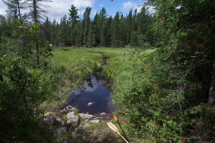
View of the east-west channel north of Boulder from the south:

The beaver dam on the east-west channel, looking toward the west. There is an easy take-out on the right in the shade of those evergreens:

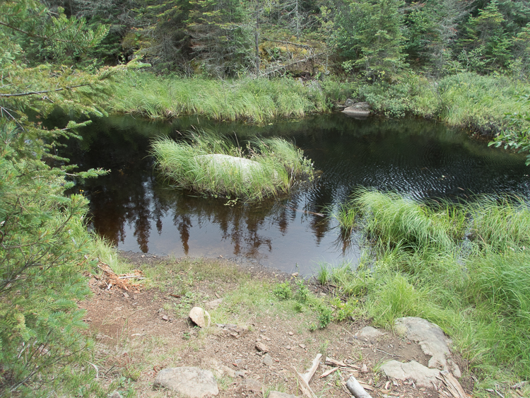
View of the east-west channel north of Boulder from the north:

Bruce
I was just through the Boulder-Cap portage(s) last week. There's actually a couple of ways to get between those two lakes. I ended up thoroughly exploring both (to put a positive spin on it ;) since I was working with two different map sources that each showed one route but not the other, and unlike you I didn't research it ahead of time.
My McKenzie map showed the portage north out of Boulder Lake being continuous and forming a T with the Cap-Ledge portage. But I had also noticed before my trip that the portage data I had loaded onto my navigation app didn't show the T occurring, and instead showed a westward paddle along the narrow east-west channel north of Boulder, and then a short portage north into Cap Lake. I had decided ahead of time that I didn't believe the McKenzie map (I had been on the Cap-Ledge portage a few years ago and didn't remember it forming a T with another portage), so I planned to take the other route.
I took the portage north from Boulder to the east-west channel north of Boulder, got back in the boat and paddled west looking for the portage north into Cap. I was going from memory because I don't like to look at my phone while on a trip, I just use it to record my track for review after the trip. I found a couple of promising spots that looked like they might be the portage but they both petered out. There is a massive beaver dam (that looks like it's been there for a few years) at the west end of that east-west channel. It turns out that the dam has drained the western end of the channel (water flows from east to west), so that it's not possible to paddle to where the portage into Cap starts. However after more scouting it turned out to be pretty easy to just land by the beaver dam and get to the start of the portage on foot. (It makes the portage L-shaped, and maybe doubles the length of it. There's a lot of hummocky grass and a few hidden logs to trip on in the drained area so caution is of course advised). But that got me to Cap Lake...
Ultimately my route was to Ledge Lake, so I then headed east on the Cap-Ledge portage. About half way through that portage I came upon the T shown on my McKenzie map. So it turns out I could have bypassed Cap Lake all together. I put my gear down at the T and hiked the trail southward back to the east-west channel north of Boulder, just to check it out (as you can see in my gps track below)
My McKenzie map wasn't exactly correct though either, it showed the portage north from Boulder going straight through with no change in direction or indication that you couldn't just trudge along all the way (maybe you could before that beaver dam flooded the upstream end of the channel). You have to get back in the boat at that channel, and as you can see from my gps tracks (if you're heading generally north along the route) there is a short offset to the west by paddle before you could get back on the trail and head for the T with the Cap-Ledge portage. I completely missed seeing where the portage picked up again heading north to the T (I guess I just wasn't expecting anything so soon after getting back in the boat).
I certainly didn't get through this area in the most efficient manner ever, but it was a fun adventure (in hindsight anyway ;)
So the route has been modified somewhat by beaver activity since my maps were made. I think there needs to be a direct line of communication between the beavers and the map makers when the beavers decide to alter a route. And my old paper maps should be automatically updated.
Here's a few pictures:
My gps tracks:

My McKenzie map (crudely marked up after the trip):

View of the east-west channel north of Boulder from the south:
The beaver dam on the east-west channel, looking toward the west. There is an easy take-out on the right in the shade of those evergreens:

View of the east-west channel north of Boulder from the north:
Bruce
07/26/2020 10:17PM
boonie: "Conditions may vary considerably from time to time. "
Yeah looks like it!
Reply
Reply with Quote
Print
Top
Bottom
Previous
Next

Subscribe to Thread
Become a member of the bwca.com community to subscribe to thread and get email updates when new posts are added. Sign up Here
 Search BWCA.com
 Donate