|
 Boundary Waters Quetico ForumListening Point - General Discussion The Long Portage
|
 Forum Sponsor

Author
Text
")

02/09/2021 02:41PM
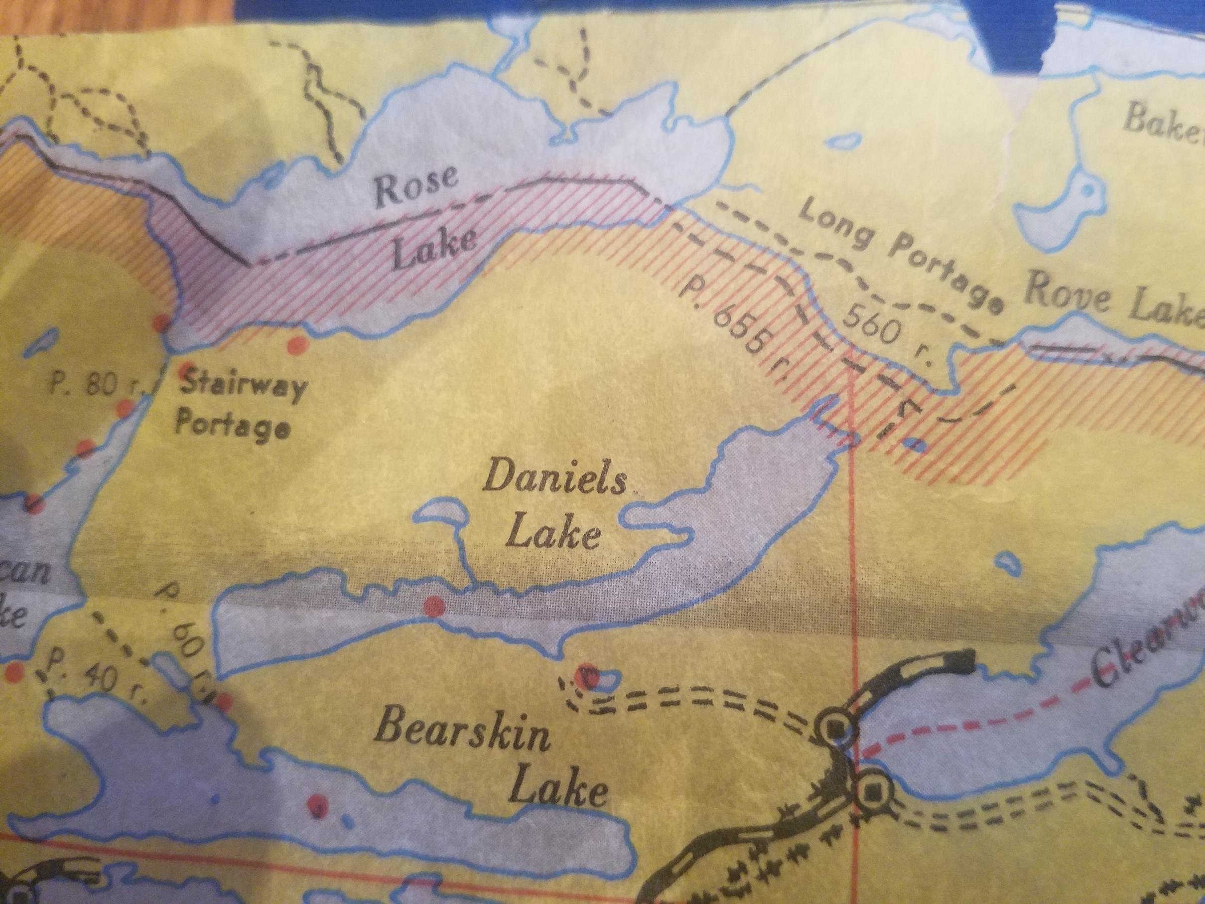
The infamous long portage is one of the historic named portages along the border. It also sits in one of my favorite sections of the BW and I have enjoyed (?) crossing it in every combination and direction. But I have known for a while that the route I have always taken is not the one on the map (at least, my map.) The long portage on most of the old maps crosses the creek shortly after leaving Rove and follows the creek on the Canadian side before crossing back over near the intersection (or some variant of that.) On the old route, the portage is separate from the BRT on the crossing to Rove with the portage being relatively flat while the BRT climbs the hill. Now, every time I have crossed it, we portaged along the apparent trail route (and it seems most everyone else does too.) I have always wondered (and the tough crossing pulling a sled a couple weeks ago reinforced the ponderings), when did that change? My assumption was that sometime in the wake of the '99 blowdown the clearing crews had a choice and cleared the trail corridor and thus it rerouted, but I have no basis for that. There are other places in the BW where there are portages on both the Canadian side and the American side and one of them (either because it is easier, better maintained, more readily apparant, or other reasons) becomes the more popular route while the other one slowly fades away. I also know the beavers have become very active along that stretch with some big chunks of the old railway grade to Rose getting soggy and flooded the last number of years. That said, the "historic" portages such as Stairway, Monument, Height of Land, and so on often tend to stay very anchored in one route. The folks that paved the way chose the spots they did for a reason, and clearing crews often keep those routes for posterity, so it's interesting if it did change. I have tried finding my answer online, and didn't much get anywhere. So, does anyone have a better answer? Did the long portage twice cross the border from Rose (or at least follow the creek) as the maps claim and, if so, when and why did it change? Thanks for the help. I love learning the history of these things.


")
02/09/2021 11:00PM
I have only taken that portage one time in 1991. I can’t help you with your answer. I do remember catching two bass on Rove, we filleted them and put the fillets in a water bottle filled with cool water. Then over the long portage to Rose lake? We camped there and ate supper after dark. I agree it was a nice long portage.
"So many lakes, so little time." WWJD
02/10/2021 08:36AM
Having done that portage quite a few times in 50 years, I thought you were wrong about the maps. I checked my newer maps- no old portage on the Canadian side of the creek. I checked my 1980 map ( a revised edition of the 1952 Fisher map) - no Canadian side portage. I checked my 1952 Fisher map- there it was, 2 portages, 1 on each side of the border. Can we assume then that the Canadian trail was abandoned between 1952 and 1980? Now I'm curious enough to look for the old Canadian trail. I'll be doing the Long Portage ( the Grand Neuf, as we all know the voyageurs called it) in early September. I won't have any time to stop and smell the flowers, or to look for old trails on the trip from Rainy L. to L. superior. It wouldn't be a legal activity anyway this year, unless they open the border. Or would it? It would be covered by treaty. I checked the book "Fur Trade Canoe Routes of Canada/ Then and Now". Eric Morse states " From Rove Lake, Grand Neuf (now Long ) Portage led to Rose Lake. The portage is rough, and it's western end leads into an abandoned rail-bed once used for logging. Morse's book was printed in 1969. At the time of his research, at least the western end of the portage is where it is today. Perhaps some intrepid explorer could check this out and give us a report, if there is any semblance of a trail.
02/10/2021 10:30AM
Voyager: It wouldn't be a legal activity anyway this year, unless they open the border. Or would it? ."
You bring up an interesting question for us. The border is obviously closed because of Covid. But the portages have always been open to use them from people of both countries under an old treaty agreement. Hmmmm
"So many lakes, so little time." WWJD
02/10/2021 04:36PM
Perhaps I was a tad unclear or asked too many questions at once, so let's try it this way. First, that's fascinating that there used to be a Canadian portage that ran the length. My main question was that most modern maps show the portage and the trail being split from Rove to the intersection with the portage following the creek with the trail separate and up on the hill. On my 2003 Mckenzie, and these newer Mckenzie and Fischers, the portage appears to be north of the international border line which would infer that they are on the Candian side. Every time I have taken the portage, it has climbed the hill on the American side and seems to share a course with the BRT. My question was, did it ever follow the creek without climbing the hill? The fact that these maps show it crossing into Canada had me curious as to that also. The lines on the USGS map I have in front of me are even more ambiguous. That said, Fisher and Mckenzie never have markings for no reason. They usually come from something in the past. I was just curious if anyone knew what part of the past caused the portage to be marked in this way.


02/10/2021 05:50PM
I see what you're saying. I think that's just a map printing issue. I've got a couple maps from the 90's and then newer maps and the campsites are about as off-set as what you're looking at there. I don't think the portage moved...i think the lines on your map just moved.
"Fool me once, shame on...shame on you. Fool me, can't get fooled again" - W
02/10/2021 06:12PM
I guess my other question was not does part of the trail go into Canada or not, but did the trail ever follow the creek as all the maps I have show? Because the trail and the portage are cleary marked as separate trails. And, as far as I know, I have never taken the one marked as the portage and the "official portage" that most people take clearly follows the green line (the BRT on these maps.)
Edited to add: If printing to show the line north of the border was a map misprint, that misprint carried over to our online mapping software as well. The map on this website clearly shows the portage on the north side of the creek from Rove to the intersection.

Edited to add: If printing to show the line north of the border was a map misprint, that misprint carried over to our online mapping software as well. The map on this website clearly shows the portage on the north side of the creek from Rove to the intersection.

02/10/2021 06:54PM
This is a great question Treebear. I wish I had definitive answers for you, but I only have speculation. I did Long Portage for the first time in September (west to east) and I have the same map info you do. As I got to the section where the map shows the portage crossing the creek I was looking north for where that could be and saw nothing. I was single portaging so I decided to just follow the worn path I was on and once I did “the climb” I knew I must be on the BRT and missed the turn. At this point I knew the BRT would get me to the water if I continued and I didn’t feel like going back with all of my gear to find the “real” portage. But...I was curious, so I put my gear down and started going back with my GPS out this time and I backtracked to the exact point where my GPS map shows the portage crossing north into Canada. There was no trail, there was a reservoir, no evidence at all of a trail on the other side. Lots of beaver activity through there, so my guess is that the old trail you’re wondering about may be underwater (and quite possibly has been for a long time as Voyager is guessing). I went back down the BRT, grabbed my gear and was soon at the landing which clearly sees a lot more traffic then just hikers. I really hope someone has more definitive info as I’m quite intrigued.
Tony
Tony
Tony
02/10/2021 09:16PM
I first took this portage in 1977 and then a number of times up to the late 1980's. I have not done it in "modern" times or since the blow down. I remember it was very flat and pretty wide at that time. We never crossed into Canada that I was aware. I also don't remember climbing a hill. I just remember lots of flats, but my memory fails me often. I definitely remember there used to be the wooden canoe rests spaced out at lovely intervals back then.
02/12/2021 04:59PM
Most of the Long Portage follows an logging old railroad grade. It was never on the Canadian side, although there may have been a portage there. Doesn't make much sense though as travelers can use portages on both sides of the border.
“Growth for the sake of growth is the ideology of the cancer cell.” -Edward Abbey
02/12/2021 06:15PM
I have a feeling that mapping portages is not something anyone in the business of making maps for the BWCA has any interest in doing super accurately. I've suspected this a number of times based on watching just how far reality deviates from the mapped portage lines on my GPS, and while doing the Canoe-Pine portage last year, I finalized my ruling. Sure, the portage does switch back and forth, but it doesn't at all follow the path mapped-out on my GPS or physical maps. I wish I had saved my route data for that one to be able to show how different the real path is from the map.

Subscribe to Thread
Become a member of the bwca.com community to subscribe to thread and get email updates when new posts are added. Sign up Here
Community Links
 Search BWCA.com
 Donate
 Featured Sponsor
