|

 Forum Sponsor

Author
Text
")


07/15/2021 07:02PM

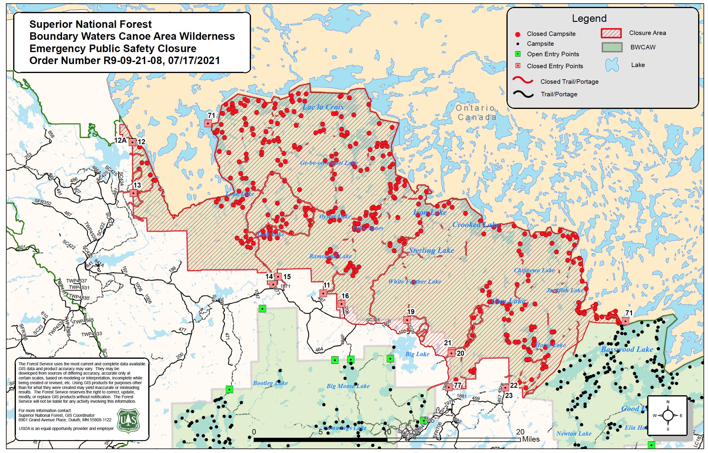
The Forest is announcing closures in the BWCAW in the Iron Lake and Crooked Lake area due to wildfires in Canada and the travel times required to move BWCAW visitors if the fires spread into the US. The Closure Order is effective on July 17, 2021 and includes:
-Crooked and Iron Lakes
-Mudro Entry Point (EP#22 and 23)
-Pristine Management Areas (PMA) of Sundial, Zones 1, 2 and 5, and all of the Tick PMA -Campsites on Wagosh, Niki and Chippewa Lakes
This Closure Order will remain in place for seven days or until conditions become safe for BWCAW travel. Wilderness rangers will initiate contact with visitors on Crooked Lake beginning Friday, July 16, 2021, and instruct them to move out of the adjacent area to safer zones. Those with reservations for the Mudro Entry Point (#22 and 23) will be contacted and redirected to other recreational areas of the Forest that do not require BWCAW quota permits to ensure they still have the opportunity to experience the Forest and its remote lakes safely.
")

07/16/2021 06:47AM
https://www.lioapplications.lrc.gov.on.ca/ForestFireInformationMap/index.html?viewer=FFIM.FFIM
The perimeters of these fires are mostly lakes so yes they are letting them burn right to the waters edge. Hopefully high winds won't be blowing sparks and embers across these lakes to start new fires.
The perimeters of these fires are mostly lakes so yes they are letting them burn right to the waters edge. Hopefully high winds won't be blowing sparks and embers across these lakes to start new fires.

07/17/2021 08:00AM
This photo is from Tiger Bay . We just got back from trip starting July 8-17. The Area was hazy especially near Warrior Hill and north. We could smell smoke. Trees and bushes are dying due to drought. Leaves all shriveled. Sunset was mostly an orange circle. No rays or pretty colors.
07/17/2021 08:12AM
IMPO, (In My Professional Opinion) if Ontario does not put the fires out and we continue to have dry weather, it is only a matter of time before they jump the water and burn in the BWCA.
May the rivers be crooked and winding, and your portages lonesome, leading to the most amazing view.
07/17/2021 09:01AM
LindenTree: "IMPO, (In My Professional Opinion) if Ontario does not put the fires out and we continue to have dry weather, it is only a matter of time before they jump the water and burn in the BWCA."
As of yesterday, a small portion of the Crooked lake fire jumped to an island on american territory. It's only a matter of time before it hits mainland...
07/17/2021 09:47AM
Lionabe: "LindenTree: "IMPO, (In My Professional Opinion) if Ontario does not put the fires out and we continue to have dry weather, it is only a matter of time before they jump the water and burn in the BWCA."
As of yesterday, a small portion of the Crooked lake fire jumped to an island on american territory. It's only a matter of time before it hits mainland..."
My retired smoke Jumper buddy who still does fires on an emergency basis is going to Saturday Bay today to monitor the fires.
Anyone who had hopes of the closure area being lifted in the next month should seriously consider plan B. It will take 3-6 inches of rain to put these fires out. Nationally there are 19,000 firefighters committed in the US. Fires burning in the BWCA along the Canadian border will be low priority nationally.
May the rivers be crooked and winding, and your portages lonesome, leading to the most amazing view.
07/17/2021 12:51PM
Lionabe: "LindenTree: "IMPO, (In My Professional Opinion) if Ontario does not put the fires out and we continue to have dry weather, it is only a matter of time before they jump the water and burn in the BWCA."
As of yesterday, a small portion of the Crooked lake fire jumped to an island on american territory. It's only a matter of time before it hits mainland..."
Which one of them/which island? The Weekend Bay ones were the closest, so I assume over there?
"Let us think the unthinkable, let us do the undoable, let us prepare to grapple with the ineffable itself, and see if we may not eff it after all."
07/17/2021 01:35PM
LindenTree: "Lionabe: "LindenTree: "IMPO, (In My Professional Opinion) if Ontario does not put the fires out and we continue to have dry weather, it is only a matter of time before they jump the water and burn in the BWCA."
As of yesterday, a small portion of the Crooked lake fire jumped to an island on american territory. It's only a matter of time before it hits mainland..."
My retired smoke Jumper buddy who still does fires on an emergency basis is going to Saturday Bay today to monitor the fires.
Anyone who had hopes of the closure area being lifted in the next month should seriously consider plan B. It will take 3-6 inches of rain to put these fires out. Nationally there are 19,000 firefighters committed in the US. Fires burning in the BWCA along the Canadian border will be low priority nationally."
I agree with this for two reasons. #1- winds have been rather light during these fires. Any wind change (front) with gusts (especially W to NW) will be issues down the road for more US areas. This Monday the 19th will be a big day for possible spread. Hopefully that is just a "thought" on my part., but the 19th will see winds the area hasn't seen in some time with active fires. #2- the long term weather looks much of the same with a "Greenland Block" over NE Canada - forcing much of the moisture S of the Wilderness area (much the case) or further to the N into FAR N Canada. This is common in winter months with just cold air and lack of falling snow- but in summer = drought. A reason for hope is that much of S.IA was in SVR drought (still is - but not updated yet) just a week ago but many areas of S.IA have seen a FOOT of rain + in the last 10 days. The problem is and I have spoken of this in the past is that much of the Arrowhead and Canoe Land sees much of the their rainfall for the season in the months that are missing it now. Once Aug comes along the avg rainfall (in a avg year) starts to decline rather fast with the "drying" of the air due to wet bulbs falling (air drying out) . Things can change rather fast weather speaking , but climo is measured over 30+ years, however, if you look at avg's and what Canoe Country "should" have seen, (climo) things do not look good ON TOP of a long range forecast that looks like this.
Some rainfall is forecasted for the region in the next 4-10 days but likely spotty and not enough to end any major fire concerns. I hope I'am wrong, but without hard core suppression efforts by fire crews , fires will get much worse. *** Note been forecasting the weather for 25+ years*** I - Sat back and wondered wtf was going in Aug 2011 with the Pagami Creek situation and the rest is history. Let's hope this doesn't led to that but imo- this season is a caliber worse than 2011 with many more fires burning and overall much drier. But that might be a good thing with advance knowledge. My personal thoughts- get'em out soon before the fall winds come howling.
The two loudest sounds known to man: a gun that goes bang when it is supposed to go click and a gun that goes click when it is supposed to go bang.
07/17/2021 07:44PM
I received an email saying my permit for Little Indian Sioux north for Tuesday was cancelling due to closures. That has to be a mistake right?? Nothing even close to there closed that I’ve seen. Anybody else get an email not nearby?
07/17/2021 08:01PM
gsfisher13: "I received an email saying my permit for Little Indian Sioux north for Tuesday was cancelling due to closures. That has to be a mistake right?? Nothing even close to there closed that I’ve seen. Anybody else get an email not nearby?"
Got this email and I had Moose/Portage River. It's real.
07/17/2021 09:58PM
Pinetree: "So what now happens with people with upcoming permits in closed area. You can't switch all of them to a open area further east."
You book for another date in another place or....head for FS lakes elsewhere. Some of which are less busy than BW lakes
07/17/2021 10:13PM
geotramper: "gsfisher13: "I received an email saying my permit for Little Indian Sioux north for Tuesday was cancelling due to closures. That has to be a mistake right?? Nothing even close to there closed that I’ve seen. Anybody else get an email not nearby?"
Got this email and I had Moose/Portage River. It's real."
Confirmed, it's real, permit cancelled. Apparently the Quetico fire didn't get the memo that the border is closed. Silly fire. Oh well, trips to the boundary waters are never about the destination, it's the journey, new journey starts tomorrow. Stay safe out there.
07/17/2021 11:10PM
gsfisher13: "geotramper: "gsfisher13: "I received an email saying my permit for Little Indian Sioux north for Tuesday was cancelling due to closures. That has to be a mistake right?? Nothing even close to there closed that I’ve seen. Anybody else get an email not nearby?"
Got this email and I had Moose/Portage River. It's real."
Confirmed, it's real, permit cancelled. Apparently the Quetico fire didn't get the memo that the border is closed. Silly fire. Oh well, trips to the boundary waters are never about the destination, it's the journey, new journey starts tomorrow. Stay safe out there."
Yes we have a permit to enjoy nature. Firefighters are working in super hot temps even before they get next to the fire. Back country fire fighting is for the young.
07/18/2021 07:32AM
geotramper: "gsfisher13: "I received an email saying my permit for Little Indian Sioux north for Tuesday was cancelling due to closures. That has to be a mistake right?? Nothing even close to there closed that I’ve seen. Anybody else get an email not nearby?"
Got this email and I had Moose/Portage River. It's real."
Just curious... did the email provide 'redirection to other recreational areas' as promised in their original notice?
Here's what they said when it was just Mudro that was closed:
"Those with reservations for the Mudro Entry Point (#22 and 23) will be contacted and redirected to other recreational areas of the Forest that do not require BWCAW quota permits to ensure they still have the opportunity to experience the Forest and its remote lakes safely."
"You can observe a lot just by watching." -- Yogi Berra
07/18/2021 01:44PM
Lionabe: "LindenTree: "IMPO, (In My Professional Opinion) if Ontario does not put the fires out and we continue to have dry weather, it is only a matter of time before they jump the water and burn in the BWCA."
As of yesterday, a small portion of the Crooked lake fire jumped to an island on american territory. It's only a matter of time before it hits mainland..."
Where did you get this information from? My contacts who work on the Superior NF were not aware of this yesterday. Here is the MODIS link that shows no heat signature south of the international border. MODIS is satellite based and run by NASA, it picks up heat signatures when the satellites fly over an area. It is possible that a small spot fire could be burning in the BWCA and MODIS is not picking it up.
MODIS heat signatures.=[tsd],viirs=[tsd],modis_a=[tsd],modis_t=[tsd],active-usa,active-ca,country-outline;@-91.8,48.3,12z
May the rivers be crooked and winding, and your portages lonesome, leading to the most amazing view.
07/18/2021 02:42PM
I just checked and discovered it was actually a unrelated lightning started fire on a Crooked lake island. I don't know the status of the fire. It was about ten miles from the fire line. The USFS website no longer lists the fire so I assume it was put out?
The link below is the government website I discovered the fire on.
USFS fire map
The link below is the government website I discovered the fire on.
USFS fire map
07/18/2021 02:48PM
Lionabe: "I just checked and discovered it was actually a unrelated lightning started fire on a Crooked lake island. I don't know the status of the fire. It was about ten miles from the fire line. The USFS website no longer lists the fire so I assume it was put out?
The link below is the government website I discovered the fire on.
USFS fire map "
I apologize for the confusion. I will try to be more accurate in the future!
07/18/2021 06:03PM
Jaywalker: "Unfortunately threads titled “More Closures” may become very confusing over the next few weeks, as I fear we are in for more of them. Perhaps we should number them, just like “Name That Lake”. "
I also think we will be seeing more closures in the future.
May the rivers be crooked and winding, and your portages lonesome, leading to the most amazing view.
07/18/2021 10:37PM
schweady: "geotramper: "gsfisher13: "I received an email saying my permit for Little Indian Sioux north for Tuesday was cancelling due to closures. That has to be a mistake right?? Nothing even close to there closed that I’ve seen. Anybody else get an email not nearby?"
Got this email and I had Moose/Portage River. It's real."
Just curious... did the email provide 'redirection to other recreational areas' as promised in their original notice?
Here's what they said when it was just Mudro that was closed:
"Those with reservations for the Mudro Entry Point (#22 and 23) will be contacted and redirected to other recreational areas of the Forest that do not require BWCAW quota permits to ensure they still have the opportunity to experience the Forest and its remote lakes safely.""
The email was actually quite helpful I thought. I looked at bunch of the links and got some ideas for alternatives. Here it is:
Dear Permit Holder or Alternate,
A full refund is currently processing for your BWCAW permit reservation due to wildfire closures. No action is required, you will automatically receive a cancellation notification from recreation.gov once processing is complete. For the latest information and closure orders, please visit Superior National Forest - Home (usda.gov) and scroll to “Alerts & Warnings” on the right side of the Forest home page. Follow the latest postings on Twitter (@SuperiorNF) or on Facebook at: U.S. Forest Service-Superior National Forest - Home | Facebook.
Entry points on the Tofte and Gunflint Ranger Districts and entry points in the Trout Lake Unit of the BWCAW (located south of the Echo Trail/Forest Road 116) are not affected by this closure order. For those wishing to rebook permits for entry points with quota still available, visit Boundary Waters Canoe Area Wilderness, Superior National Forest - Recreation.gov and click on “Explore Available Permits” or contact your BWCAW cooperator. Additionally, there are 254 backcountry campsites outside the wilderness that offer remote paddling, camping, and fishing where you can experience solitude without reservations, fees, or permits and still have a latrine and fire grate (campfire ban in effect for Superior National Forest). Visitors must follow the same Leave No Trace principles listed on page 5 of the BWCAW Trip Planning Guide. For more information on recreation alternatives outside the BWCAW, please visit: Superior National Forest - Water Activities:Boating - Non-Motorized (usda.gov) For a list of canoe routes with backcountry campsites in the Superior National Forest, visit: Canoeing 2012 rev 0415 final.pub (usda.gov)
07/18/2021 11:49PM
Jaywalker: "Unfortunately threads titled “More Closures” may become very confusing over the next few weeks, as I fear we are in for more of them. Perhaps we should number them, just like “Name That Lake”. "
It would be better to date them in the title than to number them.
07/19/2021 06:58AM
If today can run it's course without anymore fires or spreading of current ones that would be a big deal as at least some moisture in the form of raised humidity and/or rainfall is likely for the rest of the week.
Special Weather Statement
National Weather Service Duluth MN
439 AM CDT Mon Jul 19 2021
MNZ010>012-018>021-025-026-033>038-191600-
Koochiching-North St. Louis-Northern Cook and Lake-North Itasca-
Central St. Louis-Southern Lake-Southern Cook-North Cass-
South Itasca-South Cass-Crow Wing-Northern Aitkin-South Aitkin-
Carlton and South St. Louis-Pine-
Including the cities of International Falls, Ely, Isabella,
Bigfork, Hibbing, Two Harbors, Silver Bay, Grand Marais, Walker,
Grand Rapids, Pine River, Brainerd, Hill City, Aitkin, Duluth,
Pine City, and Hinckley
439 AM CDT Mon Jul 19 2021
...NEAR-CRITICAL FIRE WEATHER CONDITIONS TODAY ACROSS NORTHEASTERN
MINNESOTA...
A combination of very dry conditions with minimum relative
humidity dropping as low as 25 percent and westerly winds from 5
to 10 mph, with gusts to 20 mph, will lead to near-critical fire
weather conditions across northeastern Minnesota this afternoon
and early evening. In addition, scattered thunderstorms may
produce lightning strikes and erratic wind speeds and directions
which could further enhance the fire weather threat.
For more information on burning restrictions for Minnesota, see
www.dnr.state.mn.us/forestry/fire/firerating_restrictions.html.
$$
JTS
The two loudest sounds known to man: a gun that goes bang when it is supposed to go click and a gun that goes click when it is supposed to go bang.
07/19/2021 12:19PM
In case anyone is interested, here is how much the Quetico border fires have grown in just 6 days. If I did my math and metric conversion correctly, these 5 now have burned just under 25,000 acres, or roughly 1/4 the size of the Pagami Creek fire burn.
EDIT: Previous image mistakenly showed June 13-19. The data is from JULY 13-19.

EDIT: Previous image mistakenly showed June 13-19. The data is from JULY 13-19.

07/20/2021 07:30AM
marsonite: "jhb8426: "Those figures are a month old: June 13 - June 19, but they do indicate the rate of spread."
I wonder if he meant "July"? Wasn't the big lightning event in early July?
"
According to the Ontario fire map posted in another thread ( I think by Adam but maybe since deleted?) they did start in June.
The two loudest sounds known to man: a gun that goes bang when it is supposed to go click and a gun that goes click when it is supposed to go bang.

07/20/2021 09:25AM
This link has current fire perimeter, it is MODIS and satellite based that picks up heat signatures every time the satellite flies overhead. Use the date scroll on the bottom, you can switch between days and see how much the fire has progressed. In the last week they have really grown. Keep in mind that MODIS picks up heat signatures that is why the fires looks hollow, the interior of the fires have already burned out enough that MODIS is not picking up any heat signature there.
MODIS fire perimeter.
MODIS fire perimeter.
May the rivers be crooked and winding, and your portages lonesome, leading to the most amazing view.
07/20/2021 09:43AM
marsonite: "jhb8426: "Those figures are a month old: June 13 - June 19, but they do indicate the rate of spread."
I wonder if he meant "July"? Wasn't the big lightning event in early July?
"
Sorry everyone, sorry sorry - I did indeed type in June but meant to type in JULY. What I posted was fire growth for the last 6 days from yesterday. Image has been updated above.
07/20/2021 10:52AM
LindenTree: "This link has current fire perimeter, it is MODIS and satellite based that picks up heat signatures every time the satellite flies overhead. Use the date scroll on the bottom, you can switch between days and see how much the fire has progressed. In the last week they have really grown. Keep in mind that MODIS picks up heat signatures that is why the fires looks hollow, the interior of the fires have already burned out enough that MODIS is not picking up any heat signature there.
MODIS fire perimeter. "
That's a cool link. Thanks.
The Red Lake area fires make the Quetico area ones look like firecrackers in a bottom of a wet canoe. Red Lake area has literally 2-3 Pagami Creek fires of 2011 going on at the same time.
On a weather/climate note; expect the fires to the North (Red Lake area etc.) to slowly get exhausted by upcoming current weather and climate. This is based on the current weather patterns around the globe which don't change overnight. This also very likely means areas further S and E will feel the same effects that areas further NW felt. The "Greenland Block" I spoke of in a previous thread/post is weakening - and thus will be felt further N first- rather than S- but their is hope in a few weeks.
The two loudest sounds known to man: a gun that goes bang when it is supposed to go click and a gun that goes click when it is supposed to go bang.
07/20/2021 12:29PM
WhiteWolf: "
That's a cool link. Thanks.
The Red Lake area fires make the Quetico area ones look like firecrackers in a bottom of a wet canoe. Red Lake area has literally 2-3 Pagami Creek fires of 2011 going on at the same time."
That is probably why Canada/Ontario is not suppressing the fires north of the BWCA. I read the other day that there were 3 first nations villages/towns evacuated around the Red Lake fires, with ~5,000 people.
We can hope your prediction about the Greenland high breaking down in a couple weeks happens. I think it is only a matter of time that one or two of the fires jumps into the BWCA. I have no idea what the US response will be if that happens. I am guessing that some kind of effort to suppress or keep them in check will take place.
May the rivers be crooked and winding, and your portages lonesome, leading to the most amazing view.
07/23/2021 12:13PM
Two new fires started on July 21'st in Canada. Right across the border from Lac Lacroix and close to the Picto's I believe, each one is reported at .1 hectare in size and "not under control". Fire numbers 80 and 81.
New Fires, wait for it to load and hit accept.
New Fires, wait for it to load and hit accept.
May the rivers be crooked and winding, and your portages lonesome, leading to the most amazing view.
07/23/2021 02:26PM
Lindentree, I’m curious about what protocols might exist regarding using US wildfire assets on Canadian soil? I know from the video update that the US team are flying over the Canadian fires often to assess them, so clearly have some permission to cross over and back. But is it possible at some point that we might request from Canada that we be allowed to do air attacks or even ground crews on their soil, especially if they threaten to spread to our soil?
07/23/2021 03:05PM
Jaywalker: "Lindentree, I’m curious about what protocols might exist regarding using US wildfire assets on Canadian soil? I know from the video update that the US team are flying over the Canadian fires often to assess them, so clearly have some permission to cross over and back. But is it possible at some point that we might request from Canada that we be allowed to do air attacks or even ground crews on their soil, especially if they threaten to spread to our soil? "
We share firefighting resources with Canada regularly and vice versa. I have worked with Canadian Water Bombers, CL-415's in the L-48. They can be ordered through the Great Lakes Forest Fire Compact very easily or nationally through the National Interagency Fire Center in Boise. The GLFFC usually sends/orders state DNR firefighters to Canada, if Federal crews are sent, I believe they have to be ordered through NIFC.
I have also had Aussies working for me in 2008 in California.
IMHO, this year it may be political suicide to send US Firefighters or aircraft to a fire burning in a Canadian Wilderness when our own back yard is burning up. Today there were over 21,000 firefighters committed in the US. They have to be about tapped out as far as numbers are concerned
Great Lakes Forest Fire Compact
May the rivers be crooked and winding, and your portages lonesome, leading to the most amazing view.
07/23/2021 04:59PM
LindenTree: "Two new fires started on July 21'st in Canada. Right across the border from Lac Lacroix and close to the Picto's I believe, each one is reported at .1 hectare in size and "not under control". Fire numbers 80 and 81.
New Fires, wait for it to load and hit accept. "
A map image of the new fires 80 and 81. (Flame icons to the west of the previous, larger fires.)

"You can observe a lot just by watching." -- Yogi Berra
07/23/2021 05:53PM
schweady: "LindenTree: "Two new fires started on July 21'st in Canada. Right across the border from Lac Lacroix and close to the Picto's I believe, each one is reported at .1 hectare in size and "not under control". Fire numbers 80 and 81.
New Fires, wait for it to load and hit accept. "
A map image of the new fires 80 and 81. (Flame icons to the west of the previous, larger fires.)
"
I have a deep well of positive, wonderful things I can say about Canada and Canadians, but I do not count their ability to name wildfires among them. Their numbering system is just unimaginative.
07/23/2021 06:39PM
Jaywalker: "schweady: "LindenTree: "Two new fires started on July 21'st in Canada. Right across the border from Lac Lacroix and close to the Picto's I believe, each one is reported at .1 hectare in size and "not under control". Fire numbers 80 and 81.
New Fires, wait for it to load and hit accept. "
A map image of the new fires 80 and 81. (Flame icons to the west of the previous, larger fires.)
"
I have a deep well of positive, wonderful things I can say about Canada and Canadians, but I do not count their ability to name wildfires among them. Their numbering system is just unimaginative. "
+1
May the rivers be crooked and winding, and your portages lonesome, leading to the most amazing view.

07/24/2021 04:44PM
Minnesota Department of Natural Resources
23h · July 23
Due to unprecedented wildfire risk, the DNR has issued additional campfire restrictions in north central and northeast Minnesota, effective immediately.
Use of gas cookstoves is allowed.ons, campfires are allowed only in established fire rings inside state park, rec areas, or forest campgrounds.
Campfires in these areas are allowed only from 6 p.m. to 10 p.m.
No campfires are allowed for dispersed, remote, or backcountry camping, even if the site has an established fire ring.
Use of gas cook stoves is allowed.

Subscribe to Thread
Become a member of the bwca.com community to subscribe to thread and get email updates when new posts are added. Sign up Here
Community Links
 Search BWCA.com
 Donate
 Featured Sponsor
