|
 Boundary Waters Quetico ForumListening Point - General Discussion Severe Storm Potential Friday Night!
|
 Forum Sponsor

Author
Text
")
07/23/2021 10:59AM
There is a strong potential for severe storms tonight. Forecast models are coming into agreement that scattered severe storms could impact the BWCA between 6 PM tonight and 4 AM tomorrow morning. Winds from these storms COULD be in excess of 70 Miles per hour (112 Kilometers per hour) and hail has the potential to be larger than 1 inch (2.54 cm). If you are planning on camping in the BWCA, PLEASE consider altering your plans until these storms pass. Winds over 50 Miles per hour have been known to be deadly for campers in the BWCA. DON'T TAKE UNNECESSARY RISKS!!! Stay safe!
07/23/2021 01:56PM
The severe weather situation just went from bad to worse! This is word for word a Severe Thunderstorm Watch issued by Environment Canada for Quetico tonight (words in parentheses are mine):
"Severe thunderstorm watch in effect for:
Atikokan - Shebandowan - Quetico Park
Upsala - Raith
Conditions are favourable for the development of dangerous thunderstorms that may be capable of producing damaging wind gusts and damaging hail.
Hazards:
Hail 3 to 5 cm (1 to 2 inches) in diameter.
Damaging wind gusts to 100 km/h (Roughly 65 Miles Per Hour) . Isolated gusts to 120 km/h (Roughly 75 Miles Per Hour) possible.
A tornado or two are possible.
Where:
Portions of northwestern Ontario including Kenora, Dryden, Fort Frances, and Atikokan.
When:
Later this afternoon and evening.
Discussion:
Thunderstorms are expected to develop later this afternoon and may become severe with large hail and damaging winds. There is also a risk of a tornado. The thunderstorm risk will end later this evening after a cold front passes through the region.
Very large hail can damage property, break windows, dent vehicles and cause serious injury. Very strong wind gusts can damage buildings, down trees and blow large vehicles off the road. Lightning kills and injures Canadians every year. Remember, when thunder roars, go indoors!
Severe thunderstorm watches are issued when atmospheric conditions are favourable for the development of thunderstorms that could produce one or more of the following: large hail, damaging winds, torrential rainfall.
The Office of the Fire Marshal and Emergency Management recommends that you take cover immediately if threatening weather approaches."
As you can see, the wind forecasts look scary, but don't forget the hail. 2 inch diameter hail can seriously injure anyone it hits. Also note that tornados have entered the equation. Looks like a wild night for the BWCA and Quetico! I cannot stress this enough: If you are planning on camping in the BWCA, PLEASE consider altering your plans until these storms pass. Winds over 50 Miles per hour have been known to be deadly for campers in the BWCA. DON'T TAKE UNNECESSARY RISKS!!! Stay safe!
07/23/2021 04:09PM
The National Weather Service has issued a Special Weather Statement for the BWCA
"...STRONG TO SEVERE THUNDERSTORMS WILL AFFECT THE BOUNDARY WATERS
CANOE AREA WILDERNESS THIS AFTERNOON AND TONIGHT...
Strong to severe thunderstorms will affect the Boundary Waters
Canoe Area Wilderness this afternoon and tonight. The storms will
be capable of erratic and gusty winds of 30 to 70 mph, hail up to
half-dollar size, frequent cloud-to-ground lightning, and locally
heavy rainfall, which may lead to localized minor flooding of
creeks, streams, and low-lying areas.
Campers should take extra precautions in order to secure
campsites and make a plan in case of severe weather. Check
campsites for possible hazards, including standing dead trees or
limbs, as well as low spots where water can pool. Move tents away
from creeks and rivers in case of flash flooding. Prepare to
protect yourself from large hail using sleeping bags or other
padded Monitor NOAA Weather Radio for updates and possible
warnings."
07/23/2021 04:46PM
7/23/2021:
The National Weather Service has issued a Severe Thunderstorm Warning for the far north-western tip of the BWCA:
"Until 530 PM CDT.
* At 428 PM CDT, severe thunderstorms were located along a line
extending from near Rainy Lake West, to 6 miles south of
International Falls, to near Littlefork, moving east at 35 mph.
HAZARD...60 mph wind gusts and quarter size hail.
SOURCE...Radar indicated.
IMPACT...Hail damage to vehicles is expected. Expect wind damage
to roofs, siding, and trees.
* Severe thunderstorms will be near...
Voyageurs National Park around 435 PM CDT.
Rainy Lake West around 440 PM CDT.
Rainy Lake East around 445 PM CDT.
Other locations in the path of these severe thunderstorms include
Kabetogama and Kabetogama Lake.
PRECAUTIONARY/PREPAREDNESS ACTIONS...
For your protection move to an interior room on the lowest floor of a
building."


07/23/2021 04:46PM
I hadn’t thought of using sleeping bags to protect from hail.
So tie down the canoes gunnels down in as safe a spot as possibles. They don’t become kites and fly away.
Pick the best spot you can for the tent and tie it down. More out in the open? I’m worried about the trees falling on the tent but then the wind hits more. Tie it down iIn as many places as possible. Hopefully you brought enough extra tie downs. Make sure you Velcro to the poles in every place the rain fly can to the tent poles. Use some big rocks on top of stakes or as tie down points. Roots are great as well. Stabilize side point on tent tie downs to trees or other secure points.
I’ve got a 10 by 14 ccs tarp on a ridgeline set up. Would it make sense to keep that low but put it up over the tent as an added rainfly. Obviously it won’t stop the tree from falling it’s just another thought to stay drier. Plastic ground cloth inside the tent like Cliff Jacobson preaches so we don’t get wet in the tent, one for comfort but also for increased ground strike lightning protection. Everyone in storm position on top of pads.
I’d seal the packs down tight waterproof and strap them around trees in the campsite. They won’t blow anywhere then.
Establish a this is a safe place where We go for safety if we have to leave the tent
What am I not thinking of? Is the safest point out on the granite rock and not in the trees if you have to leave the tent. I know you want a low point for protection crevice. Not every site has an obvious protection point. Is huddling alongside an already large fallen tree an option if one is available and you don’t have an obvious safe rock protected location.
Hopefully I’m entering on a trip next Friday! At some point I’m going to be out in a storm and just want to know I know the right moves. I have a Garmin Inreach which I’ll be using for weather and would have a friend monitoring for weather warning like this in case like this one it pops up as a big storm quickly like this one did. Hopefully I’d get the in reach message. I’m sure I’d monitor more closely if thunder storms are forecasted.
I know this got discussed last year so I’ll probably search it.
Ryan
07/23/2021 05:21PM
The National Weather Service issued a Severe Thunderstorm Warning for the Western BWCA
"...A SEVERE THUNDERSTORM WARNING REMAINS IN EFFECT UNTIL 530 PM CDT
FOR EAST CENTRAL KOOCHICHING AND NORTHWESTERN ST. LOUIS COUNTIES...
At 453 PM CDT, severe thunderstorms were located along a line
extending from 8 miles north of Kabetogama Lake, to near Kabetogama,
to 8 miles southeast of Littlefork, moving east at 35 mph.
HAZARD...60 mph wind gusts and half dollar size hail.
SOURCE...Radar indicated.
IMPACT...Hail damage to vehicles is expected. Expect wind damage to
roofs, siding, and trees.
Locations impacted include...
Kabetogama, Rainy Lake East and Kabetogama Lake.
PRECAUTIONARY/PREPAREDNESS ACTIONS...
For your protection move to an interior room on the lowest floor of a
building."

07/23/2021 05:49PM
Kinda hard to alter your plans canoeing. Been through many storms... this is when it’s good to have someone in camp that knows what to look for and what safety precautions to take. It’s miserable hot with humidity on the range. If it wasn’t for the lake here to cool off in... yikes! But yeah, I see the storms coming and hoping for good amounts of rain. Be careful with campfires. I heard one campfire got away from someone near Big fork I believe. I really don’t want to be fighting fires tonight!
Nctry
07/23/2021 06:34PM
The National Weather Service has issued a Severe Thunderstorm Warning for the BWCA:
"* Until 730 PM CDT.
* At 627 PM CDT, severe thunderstorms were located along a line
extending from Boundary Waters Canoe Area Wilderness northwest of
Ely, to 11 miles northwest of Burntside Lake, to near Lake
Vermilion, moving east at 50 mph.
HAZARD...70 mph wind gusts and nickel size hail.
SOURCE...Radar indicated.
IMPACT...Expect considerable tree damage. Damage is likely to
mobile homes, roofs, and outbuildings.
* Severe thunderstorms will be near...
Burntside Lake around 645 PM CDT.
Other locations in the path of these severe thunderstorms include
Ely, Winton, Robinson, White Iron Lake, Fall Lake, Basswood Lake,
Snowbank Lake, Birch Lake, Babbitt, Forest Center and Little Saganaga
Lake.
PRECAUTIONARY/PREPAREDNESS ACTIONS...
For your protection move to an interior room on the lowest floor of a
building.
Large hail, damaging winds, and continuous cloud-to-ground lightning
is occurring with these storms. Move indoors immediately. Lightning
is one of nature`s leading killers. Remember, if you can hear
thunder, you are close enough to be struck by lightning."
Prayers for those caught in this one. Looks bad...


07/24/2021 06:15AM

I was woken up in Duluth at 5AM to some strong storms. Nothing too severe but we got pounded with an inch of rain. We had a half inch last night too so finally some relief.
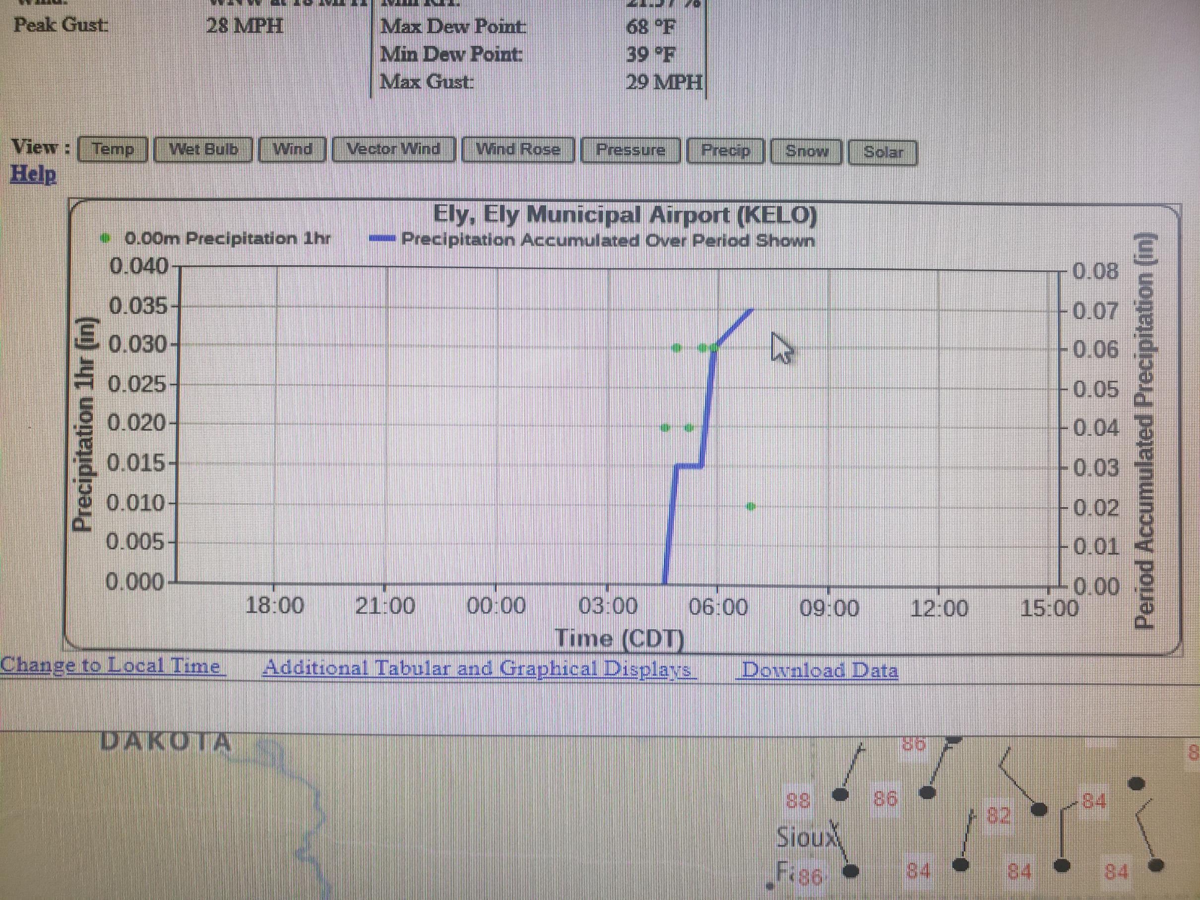
This is a screen grab showing what went through Ely around 5AM. I'm sure the campers up there got a bit of a scare as this moved through. I think the BWCA has had a good soaking but Quetico was on the north edge.
We are getting rain though which is good. And those cheap tents all knocked over, well they are pretty flimsy. They make the tamest storms look bad.
Tom
07/24/2021 08:35AM
Some rain totals from the last round of storms.
Ely .07
I Falls .53
Grand Marais .75
Eveleth .14
Meander 1.3 closest RAWS to the Canadian fires
Fernberg .42 about 10 miles south east of the fires
Seagull Guard Station .31
Skibo .19
Isabella .68
Grand Portage .07
Kabatogema .17
Duluth Airport .9
North central MN in the heart of the drought picked up considerably less all over the area. RAWS and NWS weather sites.
May the rivers be crooked and winding, and your portages lonesome, leading to the most amazing view.
07/24/2021 09:24AM
It will be interesting to see the trip reports that will hopefully come out from those that were in this. I'm heading up tomorrow and though I don't expect the fire ban to be lifted, I'm feeling a tad better about wildfire potential.
We all have to believe in something. I believe I'll go paddle.
07/24/2021 09:37AM
Better pack a saw for the portages:
"ELY – An intense thunderstorm with damaging winds and torrential rains didn’t last long when it struck here Friday evening, about 6:30 p.m. But in a matter of minutes, the storm downed numerous trees and destroyed dozens of artists’ displays assembled in Whiteside Park as the first day of the three-day Blueberry/Art Festival wrapped up. The storm uprooted trees in the park and blew tents and artwork throughout the park and, in some cases, into neighboring yards.
"Festival organizers announced late Friday evening that the remaining two days of the festival will not be held as artists and city officials focus on cleanup.
"By 8 p.m., the sounds of chainsaws could be heard all over the city as residents started to deal with the damage left behind by the storm.
"Ely Police warned residents to stay off the streets as power lines were reported down all over the city. 'Due to the severe thunderstorm and damage caused around the Ely area, we are asking the public use caution as there are power lines and trees down,' said Ely Police Chief Chad Houde. 'Please avoid these areas. The city of Ely Public Works and Fire departments are out responding to lines and trees down. Please avoid the Whiteside Park area as Blueberry Arts vendors attempt to clean up their booths.'"
Severe storm hits Ely, Blueberry Festival
07/24/2021 01:12PM
LindenTree: "Some rain totals from the last round of storms.
Ely .07
I Falls .53
Grand Marais .75
Eveleth .14
Meander 1.3 closest RAWS to the Canadian fires
Fernberg .42 about 10 miles south east of the fires
Seagull Guard Station .31
Skibo .19
Isabella .68
Grand Portage .07
Kabatogema .17
Duluth Airport .9
North central MN in the heart of the drought picked up considerably less all over the area. RAWS and NWS weather sites. "
Kind of disappointing numbers. On "What's up Ely MN" FB page, people were talking about getting around an inch in the Ely area, so I was feeling kind of optimistic. Must depend on where you had your rain gauge. Bound to be some more lightning fires popping up with those kind of totals, and I see there are two new fires east of Lake Vermilion. I've got a trip coming up in mid August, but it's written in pencil at this point.
")
07/24/2021 01:41PM
storm
Minnesota Power said Saturday its crews were working to quickly restore power to some 2,000 customers.
Storm gusts flipped multiple canoers on Trout Lake, just north of Lake Vermilion in St. Louis County, but all people were accounted for, said Jonathan Wolfe, a meteorologist at the National Weather Service Duluth.
07/24/2021 02:11PM
marsonite: "LindenTree: "Some rain totals from the last round of storms.
Ely .07
I Falls .53
Grand Marais .75
Eveleth .14
Meander 1.3 closest RAWS to the Canadian fires
Fernberg .42 about 10 miles south east of the fires
Seagull Guard Station .31
Skibo .19
Isabella .68
Grand Portage .07
Kabatogema .17
Duluth Airport .9
North central MN in the heart of the drought picked up considerably less all over the area. RAWS and NWS weather sites. "
Kind of disappointing numbers. On "What's up Ely MN" FB page, people were talking about getting around an inch in the Ely area, so I was feeling kind of optimistic. Must depend on where you had your rain gauge. Bound to be some more lightning fires popping up with those kind of totals, and I see there are two new fires east of Lake Vermilion. I've got a trip coming up in mid August, but it's written in pencil at this point.
"
I was skeptical about the Ely rain also. Had to take a look 3 times to verify. Maybe the storms blew over the weather station.
May the rivers be crooked and winding, and your portages lonesome, leading to the most amazing view.
07/24/2021 03:11PM
I set it for 12 hours from 10 this morning so it should have gotten all of it.
My personal rain gauge by Piedmont Heights in Duluth showed .6 for the whole entirety of the storms. It is about 15 feet from the house so it is possible depending how the wind was blowing that it was in a rain shadow. I think the NWS, DLH airport showed .9 for the whole storms. That is about 2 miles from our place.

My personal rain gauge by Piedmont Heights in Duluth showed .6 for the whole entirety of the storms. It is about 15 feet from the house so it is possible depending how the wind was blowing that it was in a rain shadow. I think the NWS, DLH airport showed .9 for the whole storms. That is about 2 miles from our place.
May the rivers be crooked and winding, and your portages lonesome, leading to the most amazing view.
07/24/2021 04:28PM
LindenTree: "I set it for 12 hours from 10 this morning so it should have gotten all of it.
My personal rain gauge by Piedmont Heights in Duluth showed .6 for the whole entirety of the storms. It is about 15 feet from the house so it is possible depending how the wind was blowing that it was in a rain shadow. I think the NWS, DLH airport showed .9 for the whole storms. That is about 2 miles from our place.
My gauge just up the shore past Lester Park showed .40 yesterday and .90 this morning.
I’m so glad we got something!!
Tom
07/24/2021 06:13PM
jwartman59: "In the bwca any night can be a storm. Just like you prepare for a bear attack prepare for a wind storm. Canoes on shore, lashed securely. Gear prepared for everything. This should be your daily routine."
I agree. It may seem like overkill, but I tend to baton down the hatches every night when I'm in the wilderness. I'd rather have extra stakes anchoring down my tent and not need them than have it flapping in the wind while I'm inside praying that stay dry and in one place! Tent sites are chosen based upon the safety of the location and when we first set up in a new site I take time to scout the general area to assess where to hunker down if sh*t hits the fan.
07/24/2021 09:11PM
ScottL: "jwartman59: "In the bwca any night can be a storm. Just like you prepare for a bear attack prepare for a wind storm. Canoes on shore, lashed securely. Gear prepared for everything. This should be your daily routine."
I agree. It may seem like overkill, but I tend to baton down the hatches every night when I'm in the wilderness. I'd rather have extra stakes anchoring down my tent and not need them than have it flapping in the wind while I'm inside praying that stay dry and in one place! Tent sites are chosen based upon the safety of the location and when we first set up in a new site I take time to scout the general area to assess where to hunker down if sh*t hits the fan."
+1
I do the same. I always prepare for inclement weather. Being prepared is a big part of being comfortable.
Tom
07/24/2021 09:28PM
tumblehome: "ScottL: "jwartman59: "In the bwca any night can be a storm. Just like you prepare for a bear attack prepare for a wind storm. Canoes on shore, lashed securely. Gear prepared for everything. This should be your daily routine."
I agree. It may seem like overkill, but I tend to baton down the hatches every night when I'm in the wilderness. I'd rather have extra stakes anchoring down my tent and not need them than have it flapping in the wind while I'm inside praying that stay dry and in one place! Tent sites are chosen based upon the safety of the location and when we first set up in a new site I take time to scout the general area to assess where to hunker down if sh*t hits the fan."
+1
I do the same. I always prepare for inclement weather. Being prepared is a big part of being comfortable.
Tom"
+2
"In wilderness is the salvation of mankind." Thoreau.
07/26/2021 12:33PM
I’ll just add to this that one of the reason I love going is disconnecting from everything. But a few years back I started bringing a weather radio. Perfect for a twice daily weather check-in so storms like this don’t catch you off guard.
I’d highly recommend it for like $10-$20. Mine is actually a combo with a radio, flashlight, solar and a charging handle.
I’d highly recommend it for like $10-$20. Mine is actually a combo with a radio, flashlight, solar and a charging handle.
07/26/2021 04:13PM
Watch out for some rough weather later tonight mainly S of the BWCA, Duluth area looks like the target right now, mainly large hail. 

The two loudest sounds known to man: a gun that goes bang when it is supposed to go click and a gun that goes click when it is supposed to go bang.
07/26/2021 05:17PM
WhiteWolf: "Watch out for some rough weather later tonight mainly S of the BWCA, Duluth area looks like the target right now, mainly large hail.
Yup storms forming to the NW now. Quetico, and NW Ontario are getting storms.
BWCA is getting rain and thunder too.
Tom

Subscribe to Thread
Become a member of the bwca.com community to subscribe to thread and get email updates when new posts are added. Sign up Here
 Search BWCA.com
 Donate