|
 Boundary Waters Quetico ForumListening Point - General Discussion Wildfires on the Superior NF and BWCA.
|
 Forum Sponsor

Author
Text
")


07/26/2021 06:05PM
I don't have any links yet and just saw this on KBJR news out of Duluth.
Three new wildfires are reported burning on the Superior NF.
Fourtown Lake fire in the BWCA is 15-20 acres.
Pahntom Creek fire is 3.5 acres
Bear Creek "Not certain on the name" is reported at 10 acres.
There is a weather system going through the BW and Superior NF now, but it does not appear to have much, if any rain in it. Probably just outflow winds which will not help these fires. MODIS is showing a heat signature for the Fourtown Lake wildfire.
Three wildfires in and around the BW at the same time is not a good sign as they will most likely tax out all air resources.
Feel free to post updates here as you get them.
MODIS is showing a heat signature for the Fourtown Lake fire
May the rivers be crooked and winding, and your portages lonesome, leading to the most amazing view.

07/26/2021 06:23PM
MODIS heat signature is west of Fourtown, yet Forest Service describes its location as "between Fourtown and Horse Lakes." Who does one believe?
In any case, I guess I can expect my August 1st Mudro permit to be automatically cancelled and refunded soon.
In any case, I guess I can expect my August 1st Mudro permit to be automatically cancelled and refunded soon.
"You can observe a lot just by watching." -- Yogi Berra
07/26/2021 07:28PM
I wonder how much fire it takes before it shows up on MODIS? I don't find the Phantom and Bear Creek fires on there. Must be something significant burning up on Fourtown for it to show up. I also saw on Facebook that there are two fires in Voyageurs. From the VNP:
"Recent lightning activity resulted in two wildland fires within Voyageurs National Park.
Park staff responded to a fire on Friday, July 23 at Blue Fin Bay, on Kabetogama Lake. The Kabetogama Lake Fire Department (KLFD) along with the Minnesota Department of Natural Resources (MN DNR), and the National Park Service (NPS), responded to the fire .7-acre in size. The fire has been contained.
In addition, park staff responded to a fire on Sunday, July 25 north of Lucille Lake on Sand Point Lake. The MN DNR reported the fire around 4:00 pm Sunday. The NPS, MN DNR, and the United States Forest Service (USFS) are on the ground and in the air working the fire. The fire was last reported to be seven-acres in size and has five aircraft on the scene: a T3 helicopter, a T1 helicopter, and 3 Fire Boss water scooping aircraft. This fire is in a remote, rugged area of the park, and possesses no immediate threat to the public. The National Park Service continues to be on the scene of this fire.
Park staff urge all visitors to use extreme caution while fire danger level is High in the Borderland region, including Voyageurs National Park. Currently, campfires are not permitted but camp stoves may be used, no charcoal. Park staff encourage the public to report fires in the park by calling the park’s 24-hour dispatch at (440) 546-5945 or 911"
Luckily there hasn't been much wind generally. That's a lot of little lightning fires to put out though.
07/26/2021 11:22PM
Wouldn't be surprised if more fires have started from this recent round of weather from lightning. Both Ely and Crane Lake automated lightning sensors have been very active picking up strikes the past several hours from cells that are very high (above 10,000'). These high bases don't allow much if any rainfall (evaporates) but do produce lightning. A bad combo this summer.
The two loudest sounds known to man: a gun that goes bang when it is supposed to go click and a gun that goes click when it is supposed to go bang.
07/27/2021 08:40AM
schweady: "MODIS heat signature is west of Fourtown, yet Forest Service describes its location as "between Fourtown and Horse Lakes." Who does one believe?
In any case, I guess I can expect my August 1st Mudro permit to be automatically cancelled and refunded soon.
"
 this photo says it was taken between Fourtown and Horse.
07/27/2021 11:44AM
marsonite: "I wonder how much fire it takes before it shows up on MODIS? I don't find the Phantom and Bear Creek fires on there. Must be something significant burning up on Fourtown for it to show up. "
That is a good question and one that I cannot answer, I never paid much attention to MODIS when I worked for the Fire Service, I always let others do the research for me. It wasn't until recently that I began to follow MODIS myself.
I know during the Delta fire the most MODIS showed was three squares over the fire area. Today MODIS showed 3 red squares over the Fourtown Lake wildfire, so that makes me think it was getting somewhat active comparing it with the Delta fire.
May the rivers be crooked and winding, and your portages lonesome, leading to the most amazing view.
07/27/2021 01:48PM
LindenTree: "I don't have any links yet and just saw this on KBJR news out of Duluth.
Three new wildfires are reported burning on the Superior NF.
Fourtown Lake fire in the BWCA is 15-20 acres.
Pahntom Creek fire is 3.5 acres
Bear Creek "Not certain on the name" is reported at 10 acres.
There is a weather system going through the BW and Superior NF now, but it does not appear to have much, if any rain in it. Probably just outflow winds which will not help these fires. MODIS is showing a heat signature for the Fourtown Lake wildfire.
Three wildfires in and around the BW at the same time is not a good sign as they will most likely tax out all air resources.
Feel free to post updates here as you get them.
MODIS is showing a heat signature for the Fourtown Lake fire "
Linden have you ever used CalTopo? It might come up in calif. but you can scroll over to Minn. It also shows heat west of the lake.
07/27/2021 03:56PM
This was posted on facebook today about the wildfires.
7/27 ??Superior Fires Update
Delta Lake Fire: Remains 92% contained. No smoke or hot spots noted. Suppression repair and mop-up continue.
Phantom and Bear Creek Fires: Phantom Creek, 3.5 acres, and Bear Creek, 10 acres, are both within the BWCA Wilderness. Fire crews have hose lines around perimeters.
Fourtown Lake Fire: Approx. 20 acres in size, 12 miles north of Ely. Access is a challenge. Aerial burnout operations will bring fire to a natural barrier in controlled manner. Crews are onsite. Smoke may be visible in area.
Other Superior West Zone Fires: Sundial South Fire still shows smoke but not growing. Very inaccessible. Two new fires include Ima Lake, five miles east of Snowbank, and Slowfoot, one mile southeast of the Delta Fire.
East Zone Fires: The Agamok Fire, .25 miles east of the Kekekabic Trail, is currently one acre and crews are responding. The Beth Fire was detected near a portage between Grace and Beth Lakes. A crew is responding.
All current and new fires continue to be fully suppressed by firefighters.
May the rivers be crooked and winding, and your portages lonesome, leading to the most amazing view.
07/27/2021 07:03PM
ekffazr: "That's crazy
The fact they got a handle on all of them is very impressive"
I wouldn't say that. The Fourtown Lake fire is reported as 0 percent contained this afternoon. It sounds like they are considering a burnout between Fourtown Lake and other natural barriers, I am not sure of the natural barriers being considered, but the area between Boot Lakes and Fourtown Lakes looks most logical, however that is a very large area and I remember what happened during a burnout of the Pagami Fire. Maybe there are barriers that I cannot see from the aerial map.
From Superior NF Facebook today.
"Fourtown Lake Fire Update- Smoke Visible from Ely Area??
Fire managers have assessed several management alternatives and determined that the best course of action is to conduct an aerial burnout operation to bring the fire to a natural barrier in a controlled manner. The weather window for such an operation is short, and today's conditions are favorable."
May the rivers be crooked and winding, and your portages lonesome, leading to the most amazing view.
07/27/2021 07:58PM
LindenTree: "ekffazr: "That's crazy
The fact they got a handle on all of them is very impressive"
I wouldn't say that. The Fourtown Lake fire is reported as 0 percent contained this afternoon. It sounds like they are considering a burnout between Fourtown Lake and other natural barriers, I am not sure of the natural barriers being considered, but the area between Boot Lakes and Fourtown Lakes looks most logical, however that is a very large area and I remember what happened during a burnout of the Pagami Fire. Maybe there are barriers that I cannot see from the aerial map.
From Superior NF Facebook today.
"Fourtown Lake Fire Update- Smoke Visible from Ely Area??
Fire managers have assessed several management alternatives and determined that the best course of action is to conduct an aerial burnout operation to bring the fire to a natural barrier in a controlled manner. The weather window for such an operation is short, and today's conditions are favorable.""
There does appear to be a drainage with several beaver meadows/ponds running north and south on that "peninsula" west of Fourtown. I wonder if that would serve as a fire line?
Sure is a lot of little fires. I wonder if they still have crews from the east helping out? And is this all being managed by the local ranger district?
Thankfully the weather really is pretty benign. God forbid you have all these lightning starts and then you have some hot, dry, windy days.
07/28/2021 10:41AM
MODIS really picked up for the Fourtown Lake fire today and I was guessing that the USFS had done some ignitions around the main fire to help corral it.
Then I saw this on facebook from the Superior NF.
"Sometimes you have to fight fire with fire. Aircraft were dispatched to Fourtown Lake yesterday to drop ping-pong ball-sized ignition devices to start fire. Why? The plan – which was successfully executed – was to burn off vegetation and thus remove fuel in a controlled manner. The water will serve as a natural barrier, and the fire will be less likely to send embers across the border and trigger bigger, uncontrolled fires. Check out our InciWeb page for other fire information! https://inciweb.nwcg.gov/incident/7617/"
If anyone is curious, "Ping Pong Balls" are pre filled with Potassium Permaganate and loaded aboard a helicopter the balls are put into a machine, right before they are dropped over the fire area, a needle injects them with Glycol (antifreeze) this begins a chemical reaction that starts the Ping Pong balls on fire around 30 seconds later.
Ping Pong balls and wildfires
May the rivers be crooked and winding, and your portages lonesome, leading to the most amazing view.

07/28/2021 05:36PM
marsonite: "
There does appear to be a drainage with several beaver meadows/ponds running north and south on that "peninsula" west of Fourtown. I wonder if that would serve as a fire line?
"
Good observation marsonite.
From the Duluth news tonight they said the fire was 200 acres now and from the map they showed, the western edge was exactly along those wetlands you mentioned. Perhaps on their own, those wetlands would not hold a fire, I am assuming they pretreated them with water from the air resources they have on hand before they began the aerial ignition/burnout.
May the rivers be crooked and winding, and your portages lonesome, leading to the most amazing view.
07/28/2021 07:26PM
LindenTree: "marsonite: "
There does appear to be a drainage with several beaver meadows/ponds running north and south on that "peninsula" west of Fourtown. I wonder if that would serve as a fire line?
"
Good observation marsonite.
From the Duluth news tonight they said the fire was 200 acres now and from the map they showed, the western edge was exactly along those wetlands you mentioned. Perhaps on their own, those wetlands would not hold a fire, I am assuming they pretreated them with water from the air resources they have on hand before they began the aerial ignition/burnout."
Any idea if they will mop it up? Or will they just let it smoke?
07/29/2021 09:03AM
marsonite: "
Any idea if they will mop it up? Or will they just let it smoke? "
SOP's, is to only mop up a few hundred feet inside of the control line to lesson the chance for it to slop over the line. The remainder will be allowed to smoke. If there are any campsites within the fire perimeter they may have some mitigation measures taken to minimize damage surrounding the campsites.
May the rivers be crooked and winding, and your portages lonesome, leading to the most amazing view.
07/29/2021 09:23AM
tumblehome: "And it really poured up there. Wet and soggy today. The fires are not happy.
"
According to the NWS, Ely has received .33 inches of precip over the last 3 days, and .27 from yesterdays storms.
Meander got .4 inches in the last 24 hours
Fernberg is showing .6 in the last 24 hours
Seagull GS .16
Duluth airport .06
MODIS heat signature is showing alot of heat from the fires.
I have a hunch that a few more fires will be popping up in the next few days from lightning.
NWS ELY precipitation over the last 3 days
May the rivers be crooked and winding, and your portages lonesome, leading to the most amazing view.
07/29/2021 06:25PM
Jaywalker: "On the bright side, at least the Canadian fires on the border look calmer, that is if I am reading Modi’s correctly. "
I think you are correct, from MODIS they are not even showing any heat. I'm sure they will start popping up in the next day or two if they do not receive any more rain.
May the rivers be crooked and winding, and your portages lonesome, leading to the most amazing view.
08/04/2021 09:34AM
AmarilloJim: "Any updates?
"
There are many small fires burning on the Superior National Forest, some in the BW, here is the latest fire updates from their Facebook page.
Also the Canadian fires are showing some heat again from MODIS the last couple of days, and there appears to be a new start ~50 ish miles south of International Falls.
Superior National Forest Fire Update for 8/2/21 ??
Bunggee Fire: Detected 7/30, and located south of Crooked Lake, is approximately 1.5 acre in size. Access is difficult and all resources need to be helicoptered in. Eleven people will be heading there today.
Vivid Fire: Detected 7/30, located east of Snowbank Lake and approximately five acres. Firefighters made good progress in the last few days and fire officials called this fire 100% contained yesterday afternoon.
East Zone Fires: The Agamok Fire is located a quarter mile east of the Kekekabic Trail in the BWCAW. The fire was called controlled and final mapping had it at 1.25 acres. It is no longer staffed.
Canada Fires: The Quetico Provincial Park continues to manage several fires burning north of the international border from the BWCAW. Three of these fires have potential to spread across the border into areas near Crooked and Iron Lakes. The Superior National Forest continues to monitor and assess these fires daily.
Delta Lake Fire: Fire is 100% contained. Final size is 62 acres. Crews have completed hauling out hose and other equipment and have moved on to other fires. Aircraft will continue to monitor the area.
Bear Creek and Phantom Creek Fires: The 10-acre Bear Creek Fire is located north of Mud Creek Road. The 3.5-acre Phantom Creek Fire is north of Wolf Lake Road, on the east side of Lake Vermilion. Both fires are within the BWCA Wilderness. These fires are also 100% contained. Fire crews have moved to other priority fires.
Fourtown Lake Fire: This fire, first detected on July 25th, is in the current closure area within the BWCAW by Fourtown Lake. Current size is 265 acres. Crews on the ground continue to strengthen the west and northwest firebreak by removing vegetation and putting down hose lines. Monitoring by air will continue.
Sundial South and Slowfoot Fires: Sundial South Fire, detected on July 21, still shows smoke and is currently being monitored, though not staffed. This area is particularly inaccessible to fire crews due to the remote location and hazardous fuels. The Slowfoot Fire remains at a tenth of an acre and will continue to be monitored, but not staffed.
Air Operations: Two helicopters are committed to the Forest to perform water drops as needed. Two fire bosses are available to help if needed. We request the public not fly drones over the fire area as it is a safety hazard to aircraft and is prohibited. Air operations will stop if drones are detected in the area.
Closures: Closures remain in place on the Kawishiwi and LaCroix Ranger Districts adjacent to the Canadian border in BWCAW. For details, visit the Superior National Forest webpage at: https://www.fs.usda.gov/alerts/superior/alerts-notices. The Superior National Forest continues to evaluate the closure areas daily to determine next steps based on weather conditions and fire activity. The closures will remain in place until fires near the border are not a threat.
May the rivers be crooked and winding, and your portages lonesome, leading to the most amazing view.
")
08/06/2021 01:37PM
Minnesota Department of Natural Resources
1h ·
Campfire restrictions continue to be in effect in Minnesota's north central and northeast counties.
No campfires are allowed on DNR-managed lands, including state parks, recreation areas, and forests in these counties.
This applies to ALL campsites, camper cabins, picnic areas, and other areas within these lands.
Pack Right! Only camp stoves are allowed under current burning restrictions. Grills are prohibited. Charcoal is not permitted, including in a fire ring or grill.
A camp stove is defined as a stove or grill that is solely fueled by liquid petroleum or liquid petroleum gas (LPG) fuels (pressurized liquid or gas stove).
Find out what state parks, recreation areas, and forests are affected: go.usa.gov/x6Syv
08/10/2021 06:15PM
Update from Superior NF's Facebook about the fires.
Also MODIS is showing a lot of new activity from the fires in Canada across from Crooked Lake.
"Superior National Forest Fire Update 8.10.21 ??
Things are looking good today ??! The Superior National Forest has taken over management of all fires and will be providing updates on the fire situation and the closure area every other day or as needed. The Forest continues to have outside resources assisting in suppression and patrol and monitoring.
Drought conditions persist throughout Minnesota and Canada. Over the next several days higher winds are predicted to increase the potential of critical fire weather; however, chances of trace amounts of isolated precipitation and slightly higher humidity levels will slightly moderate fire activity in the short-term. The moisture deficit will continue to worsen as significant rainfall is not predicted in Northern Minnesota.
Bunggee Fire: The Bunggee Fire was first detected on July 30th and is located within the current closure area. The 3.5-acre fire has saw line and hose lay around it and very minimal fire activity has been observed the last few days. The fire is being patrolled and monitored.
Fourtown Lake Fire: The Fourtown Lake Fire was first detected on July 25th and is located within the BWCAW approximately 12 miles north of Ely. The current size is 265-acres and continues to hold within containment lines. Six firefighters are staffing the fire and continuing mop up.
Sundial South Fire: The Sundial South Fire was detected on July 21, and is a quarter-acre in size. It is located within the existing closure area and is particularly inaccessible to fire crews due to the remote
location and hazardous fuels. Fire activity remains minimal, but will be continuously monitored by air.
Moose Camp Fire: The Moose Camp Fire was detected on August 4th and is located approximately 16 miles NNE of Ely. It is a quarter-acre, 100 percent contained and is in patrol and monitor status.
Nina Creek Fire: The Nina Creek Fire was detected on August 4th and is located approximately 12 miles SE of Ely. It is 2.7-acres and is 100 percent contained. Firefighters are finishing mop up and pulling gear.
East Zone Fires: There are currently no active fires on the East Zone of the Superior National Forest. Aircraft will continue to monitor previous fires and look for any new starts.
Canada Fires: Quetico Provincial Park continues to manage several fires burning north of the international border from the BWCAW. Three of these fires have potential to spread across the border into areas near Crooked and Iron Lakes. In the last few days, these fires have not grown significantly, but fire activity is moderate. The Forest continues to conduct daily monitoring flights over the fires and coordinate with counterparts in Ontario. For more information on the fires in Ontario and for an interactive fire map visit: https://www.ontario.ca/page/forest-fires.
outdoor air quality at the agency's Air Quality and Health webpage.
Closures: Closures remain in place on the Kawishiwi and LaCroix Ranger Districts until at least August 13. Closures are adjacent to the Canadian border in BWCAW. For details, visit the Superior National Forest webpage at: https://www.fs.usda.gov/alerts/superior/alerts-notices. With continued fires, the closure allows firefighters to take immediate action on existing fires or any new starts."
MODIS Canada fires.
May the rivers be crooked and winding, and your portages lonesome, leading to the most amazing view.
08/10/2021 10:27PM
The Tamarack fire out here has caused a change in USFS policy on monitoring fires. They said they would monitor a lightning fire. The reason given was the fire was in light fuels with little potential for growth. A few days later the wind shifted and the fire wound up over 68,000 acres. Hopefully this will also end USFS managing fires. During drought conditions as we all have now all fires should be full suppression.
08/11/2021 09:30AM
Most areas saw less than 1/3rd an inch. The next week looks very dry with more wind / rather low relative humidities than the area has seen in just about since the fires started early this summer. Would not be surprised to see a fire weather watch one of these upcoming days. 

The two loudest sounds known to man: a gun that goes bang when it is supposed to go click and a gun that goes click when it is supposed to go bang.
08/12/2021 06:08PM
WhiteWolf: "Most areas saw less than 1/3rd an inch. The next week looks very dry with more wind / rather low relative humidities than the area has seen in just about since the fires started early this summer. Would not be surprised to see a fire weather watch one of these upcoming days.
What is your SWAG for the next month. Any relief in sight?
08/12/2021 06:23PM
Jaywalker: "The fires in Canada are looking hotter on Modis, if I’m reading it correctly. Not sure what the difference is between red and orange squares, but reckon both are bad. 15-20 mph winds up there today can’t be helping.
Modis "
I think you are reading MODIS correctly, Ely got .33 inches of rain yesterday morning and the Meander Remote Area Weather Station (the closest WX station to the canadian fires) got around the same. After a little rain, MODIS shows little fire activity for a couple days. The fires will start picking up by tomorrow or the day after.
The west zone of the Superior NF (Kawashiwi, Laurention and Cook ranger districts) had two new starts after yesterdays storm. Sounds like they have caught them, keeping them both under an acre.
May the rivers be crooked and winding, and your portages lonesome, leading to the most amazing view.

08/15/2021 04:31PM
A little early for some concrete info but it looks like a wildfire is getting a good head of steam on it south of McDougal Lake by Isabella.
May the rivers be crooked and winding, and your portages lonesome, leading to the most amazing view.
08/15/2021 04:48PM
NWS upgraded my previous post to a Fire Weather Watch until 8pm tonight. RH's are in mid to low 20s%® with SW winds gusting to 25 to 30 mph.
The two loudest sounds known to man: a gun that goes bang when it is supposed to go click and a gun that goes click when it is supposed to go bang.
08/15/2021 05:39PM
NordSteve: "MPR reports that two new fires were caused by illegal camp fires.
https://www.mprnews.org/story/2021/08/15/amid-ongoing-fire-danger-bwca-closure-order-will-remain-in-place-at-least-through-friday"
Link
May the rivers be crooked and winding, and your portages lonesome, leading to the most amazing view.
08/15/2021 05:39PM
LindenTree: "A little early for some concrete info but it looks like a wildfire is getting a good head of steam on it south of McDougal Lake by Isabella."
Yes a little too up close and personal for
me. I was at my cabin near Sand Lake, putting my canoe on my truck for tomorrow’s canoe trip, and I heard a plane them another, then looked and saw white smoke. South of us. Wrong direction. I drove down there to reconnoiter. By the time I got
Back there was a nice dark plume forming glowing red underneath. The USFS was there evacuating us. A little more excitement than we were looking for. Got a campsite at Fall Lake. Not much we can do about the fire. You can see the plume from Ely so this is a real fire.

08/15/2021 06:03PM
marsonite: "The fire looked to me to be just north of Greenwood lake. I took this picture from Highway 1 about 10 miles east of Ely."
From facebook USFS Superior NF.
New: Greenwood Fire ?? 8.15.2
The Greenwood Fire was detected today around 3 pm on the Laurentian Ranger District. The fire is near Greenwood Lake and approximately 15 miles southwest of Isabella, MN. The current size is unknown and estimated to be a couple hundred acres and moving quickly. An aircraft is flying right now and will have a better estimate of the size shortly. The Forest Service is actively suppressing the fire with air and ground resources, working in partnership with county and state resources to respond. Smoke will likely be visible in the area. We will update as soon as we have more information.
May the rivers be crooked and winding, and your portages lonesome, leading to the most amazing view.
08/15/2021 06:20PM
My thoughts as a retired Wildland Firefighter.
The Greenwood fire is going to be a big issue.
If a fire of this size is estimated to be 200+ acres in this initial stage and with the predicted dry weather, it is likely to get much bigger with the current fire indexes and dry weather forecasted for the next week. This fire will likely take a few hundred firefighters "or more" to put it to bed.
May the rivers be crooked and winding, and your portages lonesome, leading to the most amazing view.
08/15/2021 06:38PM
Mocha: "Is it possible the camper caused fire sparked the fire near Isabella? Seems homestead lake and Greenwood lake are about 9 miles apart?"
I doubt it, that is around 20 miles away by the way the crow flies, the only Homestead Lake I know of is right near Hogback Lake.
May the rivers be crooked and winding, and your portages lonesome, leading to the most amazing view.

08/15/2021 07:36PM
LindenTree: "Mocha: "Is it possible the camper caused fire sparked the fire near Isabella? Seems homestead lake and Greenwood lake are about 9 miles apart?"
I doubt it, that is around 20 miles away by the way the crow flies, the only Homestead Lake I know of is right near Hogback Lake."
That fire started in the middle of nowhere so I don’t think it was a campfire. Theres really nothing down there but winter logging roads and thick, thick woods. I’m wondering if it’s a lightning fire that’s been smoldering for many days.
The access to this fire should be pretty good along the LTV tracks and the power line. Hopefully they can get some cats in there and build some fire line pretty quickly. Also there’s a lot of spruce bog that I don’t think burn that well. Time will tell.
08/15/2021 08:05PM
marsonite: "LindenTree: "Mocha: "Is it possible the camper caused fire sparked the fire near Isabella? Seems homestead lake and Greenwood lake are about 9 miles apart?"
I doubt it, that is around 20 miles away by the way the crow flies, the only Homestead Lake I know of is right near Hogback Lake."
That fire started in the middle of nowhere so I don’t think it was a campfire. Theres really nothing down there but winter logging roads and thick, thick woods. I’m wondering if it’s a lightning fire that’s been smoldering for many days.
The access to this fire should be pretty good along the LTV tracks and the power line. Hopefully they can get some cats in there and build some fire line pretty quickly. Also there’s a lot of spruce bog that I don’t think burn that well. Time will tell. "
Back in 1976 wen it was so dry-spruce bogs and peat fires are extremely hard to put outwhen they can burn down deep. Maybe water still in the bog areas?
08/15/2021 08:38PM
smoke: "Old rule....initial estimate of fire size in acres. Divide by 2, at night divide by 4. Possible sleeper fire. A deep peat fire can overwinter and and can be very dangerous in that the ground above can appear to be solid and safe to walk on."
I saw on one of my radar apps (also shows fires) that the fire size is being reported as 750 acres.
"In wilderness is the salvation of mankind." Thoreau.
08/15/2021 09:09PM
airmorse: "smoke: "Old rule....initial estimate of fire size in acres. Divide by 2, at night divide by 4. Possible sleeper fire. A deep peat fire can overwinter and and can be very dangerous in that the ground above can appear to be solid and safe to walk on."
I saw on one of my radar apps (also shows fires) that the fire size is being reported as 750 acres."
Incident Information
Greenwood Fire
Incident Type: Wildfire
Percent Contained:
Size: 750 acres
Last Updated: 59 Minutes Ago
08/15/2021 09:19PM
Pinetree: "airmorse: "smoke: "Old rule....initial estimate of fire size in acres. Divide by 2, at night divide by 4. Possible sleeper fire. A deep peat fire can overwinter and and can be very dangerous in that the ground above can appear to be solid and safe to walk on."
I saw on one of my radar apps (also shows fires) that the fire size is being reported as 750 acres."
Incident Information
Greenwood Fire
Incident Type: Wildfire
Percent Contained:
Size: 750 acres
Last Updated: 59 Minutes Ago"
Yup. That's the one. Got a bad feeling about that one.
"In wilderness is the salvation of mankind." Thoreau.
08/15/2021 10:05PM
TechnoScout: "WhiteWolf: "Most areas saw less than 1/3rd an inch. The next week looks very dry with more wind / rather low relative humidities than the area has seen in just about since the fires started early this summer. Would not be surprised to see a fire weather watch one of these upcoming days.
What is your SWAG for the next month. Any relief in sight?"
I will post an update soon. My weekend off. Sorry for the delay.
The two loudest sounds known to man: a gun that goes bang when it is supposed to go click and a gun that goes click when it is supposed to go bang.
08/16/2021 12:23AM
whyzata: "The smoke plume is visible on satellite with smoke blowing to the NE. Location 47.3458, -91,3722"
It's also visible on the "fire channel" at night. As is the one in Quetico that seems to be growing.Not good. Southerly winds for the next few days followed by a switch in winds to the NW'ery direction. That will be a MAJOR telling on how this affects possible additional closures further E than current closures. One more fire on the size of the current fire near the coordinates above- but east and North- has the potential to shut down some entry points in the BW east of Basswood. Something to ponder. I would not be shocked if this happens.
.

The two loudest sounds known to man: a gun that goes bang when it is supposed to go click and a gun that goes click when it is supposed to go bang.
08/16/2021 01:57AM
Duluth news:
The blaze apparently started just north of Greenwood Lake, and just east of Lake County Highway 2, said Lake County Sheriff Carey Johnson. Johnson said the apparent cause was a power line blown down in strong winds and sparking on the ground.
The blaze apparently started just north of Greenwood Lake, and just east of Lake County Highway 2, said Lake County Sheriff Carey Johnson. Johnson said the apparent cause was a power line blown down in strong winds and sparking on the ground.
08/16/2021 07:17AM
Pinetree: "Duluth news:
The blaze apparently started just north of Greenwood Lake, and just east of Lake County Highway 2, said Lake County Sheriff Carey Johnson. Johnson said the apparent cause was a power line blown down in strong winds and sparking on the ground."
This fire grew to more than 250 acres from the time it was discovered on 8-17.
Will probably grow substantially this week. Hot, dry, and windy.
Tom
08/16/2021 07:24AM
LindenTree: "My thoughts as a retired Wildland Firefighter.
The Greenwood fire is going to be a big issue.
If a fire of this size is estimated to be 200+ acres in this initial stage and with the predicted dry weather, it is likely to get much bigger with the current fire indexes and dry weather forecasted for the next week. This fire will likely take a few hundred firefighters "or more" to put it to bed.
"
Yep. This one has the potential to compete at a right angle with the Pagami Creek fire. Extrapolated forecast is available at Extrapolated forecast at Greenwood Lake
(Scroll down past the reported Ely observations.)
08/16/2021 08:40AM
Judging from MODIS, I would guess the fire at around 1,000-1,500 acres.
Greenwood Lake is 1,300 acres so I am using that for a reference. One of my co-workers just got called for this fire. He is Incident Commander of one of the Eastern Area type 2 incident management teams, that was just mobilized for this fire. He is a solid firefighter from Aitkin and works for the MN-DNR, this fire will be in good hands. Hope the weather cooperates.
There are many fires burning in the state now, scroll out with MODIS and you will see one by Lake of the woods and another one by Red Lake, as well as a few smaller ones.
MODIS Greenwood Fire
May the rivers be crooked and winding, and your portages lonesome, leading to the most amazing view.
08/16/2021 08:41AM
"
Yep. This one has the potential to compete at a right angle with the Pagami Creek fire. Extrapolated weather forecast is available at Extrapolated forecast at Greenwood Lake
(Scroll down past the reported Ely observations.)
LindenTree: "My thoughts as a retired Wildland Firefighter.
The Greenwood fire is going to be a big issue.
If a fire of this size is estimated to be 200+ acres in this initial stage and with the predicted dry weather, it is likely to get much bigger with the current fire indexes and dry weather forecasted for the next week. This fire will likely take a few hundred firefighters "or more" to put it to bed.
"
Yep. This one has the potential to compete at a right angle with the Pagami Creek fire. Extrapolated weather forecast is available at Extrapolated forecast at Greenwood Lake
(Scroll down past the reported Ely observations.)
08/16/2021 08:59AM
From the Superior NF's facebook page about current fires.
"Superior National Forest Evening Fire Update ?? 8.15.2
Three new fires were detected on the forest this weekend. High winds and dry vegetation are contributing to the high number of new fire starts we are seeing each week. For more information or questions, call our fire information line: 218-499-9441.
GREENWOOD FIRE & CLOSURES: The Greenwood Fire was detected today near Greenwood Lake on the Laurentian Ranger District. It is approximately 15 miles SW of Isabella. The fire is moving very quickly due to strong gusts of wind and dry vegetation and is estimated to be several hundred acres. Fire crews are suppressing the fire on the ground and from the air. This afternoon, the Forest Service, Lake County and Minnesota Department of Natural Resources notified residents in the McDougal Lake area that evacuation may be needed, and to be prepared. Lake County is the lead on public safety and evacuations.
Closures: Effective today, the McDougal Recreation Area is closed including McDougal Lake Campground, McDougal Lake Boat Ramp, McDougal Lake Picnic Area and McDougal Lake Trailhead and Trail. The area will be reopened when it is safe to do so.
JOHN ELK FIRE: Detected late on August 14, the John Elk Fire was started with a lightning strike. It is in a remote area 2.5 miles south of Little Saganaga Lake in the Wilderness on the Tofte Ranger District. No fire-fighting crews have been sent in due to difficult access, limited helicopter resources and safety concerns. A helicopter with water drops is being used to knock down flames and limit the spread. It is currently two-acres. On August 15th, a 2 person wilderness ranger crew paddled in from Little Sag to make contact with BWCAW permittees to inform them on the John Elk Fire, and update them on fire conditions.
WHELP FIRE: The Whelp Fire is another lightning-caused fire that was detected late on August 14. It is four miles west/northwest of Sawbill Lake. Similar to the John Elk Fire, this fire is in a remote area of the Wilderness on the Tofte Ranger District. No fire-fighting crews have been sent in due to difficult access, limited helicopter resources and safety concerns. Aircraft will perform water drops to suppress this fire as we continue to gather information. On August 16th, a 2-person wilderness ranger crew will paddle the Louse River to contact permittees near the Whelp Fire. It is currently five-acres."
??: Greenwood Fire on August 15, 2021/USDA Forest Service.
May the rivers be crooked and winding, and your portages lonesome, leading to the most amazing view.
08/16/2021 10:04AM
If the Greenwood fire grows as much today as it looks on MODIS to have grown yesterday, it would not be all that far from Hwy 1 in a day or so. I can’t help but wonder if there is a risk to it being closed due to fire or just smoke?
Fire crews in the area have been playing whack-a-mole for about two months, with several new fires just in the last week. With a bigger fire like Greenwood popping up so fast, it’s got to be tough to decide how to allocate the resources we have here now knowing it could take time to get new resources, if they are available.
Fire crews in the area have been playing whack-a-mole for about two months, with several new fires just in the last week. With a bigger fire like Greenwood popping up so fast, it’s got to be tough to decide how to allocate the resources we have here now knowing it could take time to get new resources, if they are available.
08/16/2021 12:14PM
Timberjay News:
ISABELLA— A fire that started near Greenwood Lake in Lake County had grown to approximately 1,500 acres as of Monday morning, Aug. 16, with days of potentially critical fire weather in the forecast. With drought conditions ranging from severe to extreme in the area, the U.S. Forest Service ordered the evacuation of the McDougal Lake Campground and associated recreational amenities.
ISABELLA— A fire that started near Greenwood Lake in Lake County had grown to approximately 1,500 acres as of Monday morning, Aug. 16, with days of potentially critical fire weather in the forecast. With drought conditions ranging from severe to extreme in the area, the U.S. Forest Service ordered the evacuation of the McDougal Lake Campground and associated recreational amenities.
08/16/2021 01:37PM
If I was neGREENWOOD FIRE UPDATE ?? 8.16.2
SUMMARY: The Greenwood Fire was detected on August 15, 2021 around 3 pm on the Laurentian Ranger District. The fire is near Greenwood Lake and approximately 15 miles southwest of Isabella, MN. The current size is unknown and estimated to be at least one thousand acres. Today, the fire is expected to continue spreading northward due to southerly winds. Yesterday, the fire was extremely active and was spotting and crowning, and grew rapidly due to high gusts of winds and dry conditions.
Aircraft flew the area this morning to get a better estimate on the footprint. The cause of the fire is currently under investigation. Fire crews are suppressing the fire on the ground and from the air.
RESOURCES: The Forest Service and Lake County are currently in unified command responding to the Greenwood Fire. The Forest has ordered a Type 2 Incident Management Team to support the response to this fire and the team will likely arrive on site sometime tomorrow.
WEATHER: Expect to see near critical fire weather this afternoon and evening across Minnesota. Temperatures in the Greenwood Fire area will be around 85 degrees with humidity levels will be roughly around 35 percent and southerly winds from 5-15 mph with gusts of 20 to 25 mph.
SAFETY EVACUATIONS: Today, the McDougal Lake area is under evacuation. Yesterday, the Forest Service, Lake County and Minnesota Department of Natural Resources notified residents in the McDougal Lake area to be prepared in case in evacuation was necessary. Lake County is the lead on public safety and evacuations. There are reports of extensive ash and smoke along Highway 1. Please exercise caution while driving.
CLOSURES: Effective August 15, the McDougal Lake Recreation Area on the Tofte Ranger District is closed. This includes McDougal Lake Campground, McDougal Lake Boat Ramp, McDougal Lake Picnic Area, McDougal Lake Trailhead and Trail. Today, the closure order is being expanded to include Little Isabella Campground, Flat Horn/ Gegoka Ski Trails and Trailheads (Trail 71093 and 71093 Spur trails A ,B ,C, D ,E, F, FA ,FB, G, GA ,H, I ,and J ), Lake Gegoka Boat Access, Stony River Observation Site, Stony River Canoe Launch, Flat Horn Lake Picnic Area, Flat Horn Lake Boat Launch, Dragon Boat Launch, Beetle Boat Launch, Grass Boat Launch, Two Deere Boat Launch, Little Wampus Boat Launch, Sand Lake Boat Launch, Bearskin Lake Boat Launch, Surprise Lake Boat Launch, Grouse Lake Boat launch, Shamrock Boat Launch, Chub Lake Boat Launch, Dunnigan Lake Boat Launch and Gypsy Lake Boat Launch. This will be updated on the Superior National Forest alerts and notices page today.
AIR QUALITY: The MPCA has issued an Air Quality Alert for inland Lake County due to wildfire smoke from the Greenwood Fire effective through 3 p.m. Tuesday. The affected area will be limited to areas near and directly downwind of the fire to the north and northeast.
For Greenwood Fire information, visit Inciweb.nwcg.gov or call 218-499-9441. For information on closures, visit the Superior National Forest alerts and notices page. For all other fires on the Superior National Forest, please call 218-214-7844. ar HWY 1 I would start thinking about scrambling..Unfortunate..
08/16/2021 01:39PM
Due to the Greenwood fire, the following roads are currently closed:
?? Highway 2 is closed from Forest Hwy 11 to Hwy 1
?? Highway 1 is closed from New Tomahawk Rd to Lankinen Rd
FYI: Lankinen Rd is in down town Isabella, it goes to the community center.
May the rivers be crooked and winding, and your portages lonesome, leading to the most amazing view.
08/16/2021 06:22PM
Duluth news great writeup and pictures-hope you can get it
Carl from facebook:
In this fast developing situation, this video update unfortunately is already out of date, in that Hwy 1 is now also closed and the fire is estimated to be at least 2000 acres and growing.
It would be nice to get some update on other area fires, too. From the smoke I'm seeing to the north, it appears that the Fourtown fire has been whipped back to life and is putting up some serious smoke clouds. I suspect hot spots in some other fire areas have also become active in this windy, dry weather.
08/16/2021 07:50PM
Pinetree: "
Carl from facebook:
In this fast developing situation, this video update unfortunately is already out of date, in that Hwy 1 is now also closed and the fire is estimated to be at least 2000 acres and growing.
It would be nice to get some update on other area fires, too. From the smoke I'm seeing to the north, it appears that the Fourtown fire has been whipped back to life and is putting up some serious smoke clouds. I suspect hot spots in some other fire areas have also become active in this windy, dry weather."
We will learn alot in the next day or two as the Eastern Area Incident Management team takes over this fire. IMHO, this fire could burn into the BWCA in the next couple days given the predicted weather.
What happened today will be critical and we don't know much about todays operations.
Were the aerial resourses able to stop/slow the foreword spread? We will know soon, if they were not able to slow it down much it will be a long hard fight for the next 3-4 days, and for the next couple of weeks, at least.
Edit, if they can keep the fire south of Hwy 1 today (8/17) I think they will catch it in time and it will not hit the BW.
May the rivers be crooked and winding, and your portages lonesome, leading to the most amazing view.
08/16/2021 08:37PM
Pinetree: "St. Louis County Sheriff news release: ROAD CLOSURES
Due to the Greenwood fire, the following roads are currently closed:
Highway 2 is closed from Forest Hwy 11 to Hwy 1
Highway 1 is closed from New Tomahawk Rd to Lankinen Rd"
Prayers for the communities involved... come on White Wolf... bring us a good weather report! Anything shaping up for our rain chances this weekend or is it wishful thinking?
Nctry
08/16/2021 09:51PM
Pinetree: "If it reaches highway 1 it is really raging,than I agree and much of the BWCA like Bald Eagle could be closed.There talking Tomahawk trail closing maybe in the future?"
Let’s say it jumps across Hwy 1 at MacDougal, what are the odds the Bald Eagle lake area will get shut down? Anyone’s guess at this point?
08/16/2021 10:01PM
anthonylane: "Pinetree: "If it reaches highway 1 it is really raging,than I agree and much of the BWCA like Bald Eagle could be closed.There talking Tomahawk trail closing maybe in the future?"
Let’s say it jumps across Hwy 1 at MacDougal, what are the odds the Bald Eagle lake area will get shut down? Anyone’s guess at this point?"
Gets that close,it will not be if, it will close. They can't stop it by highway 1 were in very big trouble.
08/17/2021 02:19AM
nctry: "Pinetree: "St. Louis County Sheriff news release: ROAD CLOSURES
Due to the Greenwood fire, the following roads are currently closed:
Highway 2 is closed from Forest Hwy 11 to Hwy 1
Highway 1 is closed from New Tomahawk Rd to Lankinen Rd"
Prayers for the communities involved... come on White Wolf... bring us a good weather report! Anything shaping up for our rain chances this weekend or is it wishful thinking?"
Local NWS forecasts may have chances of rain over the next week to 10 days-- and that's good-- a glimmer of hope. But I personally don't see the chances as high as they do-- ( drought breeds drought and the "promise" of rain over the past 2-4 months from 5-10 days out has been fleeting) and for sure not anything close to mitigating this current fire hazard. It's going to take until the snow flies. Any heavy rains will be few and far between and trying to say the fire areas will be the ones that get those is a shot in the dark. It does appear to cool down for the Arrowhead to "normal" temps however in about 5 days. The following graphic is crude and should be taken lightly - but is the latest euro weather model on rainfall for the next week. (IT DOES VERY BAD ON THUNDERSTORMS at this range) but pretty good on wide scale synoptic rain systems --so- don't expect any major improvements over a large area in the worst fire areas overs the next 168 hours at least. But more importantly other than this graphic- which does agree- is that the pattern is not going to change for some time. The tropical activity in the ATL does not help as it tends to act like a road block and slow the typical W to E pattern down even more while persisting the current weather pattern. Lots of factors- but I don't see a "big" change in the pattern until 2-3 weeks.

The two loudest sounds known to man: a gun that goes bang when it is supposed to go click and a gun that goes click when it is supposed to go bang.
08/17/2021 04:43AM
And basically what I wrote above is what NWS Duluth said in their discussion this AM, though rainfall, Imo, later this week is not as widespread, accumulating as they say.
Area Forecast Discussion
Issued by NWS Duluth, MN
Home | Current Version | Previous Version |
Area Forecast Discussion
National Weather Service Duluth MN
315 AM CDT Tue Aug 17 2021
.DISCUSSION...(Today through Monday)
Issued at 315 AM CDT Tue Aug 17 2021
Summary: Near-critical fire weather conditions will persist
through at least Thursday. Gusty southerly winds will continue
through Friday. Delays in the onset of precipitation being shown
by deterministic models.
The pattern hasn`t changed from yesterday, keeping the tight
pressure gradient over the Northland today through Friday. This is
the result of a blocking surface pattern, with the landfall of
Tropical Storm Fred, and surface low pressure organizing over the
lee of the Rockies. Upper level ridging was also covering the
area, helping to keep the pattern in place. Gusty southerly winds
result from these features. The southerly winds will pump in warm
to hot air, even though low level moisture will be on the increase
with dewpoints reaching into the 60s. The near-critical fire
weather conditions will therefore prevail during this time, as
humidities are generally in the 35 to 45 percent range over the
Northland, lowest in northeast Minnesota.
A closed upper low will form along the Wisconsin/Illinois border
Wednesday and meander into the eastern Great Lakes, before
opening into a trough. This feature results in the aforementioned
surface low only moving slowly east into the western Dakotas
Thursday night. Little in the way of rain is expected before then,
and the gradient weakens and tightens occasionally during this
time. The NBM brings pops into the area as early as Thursday
afternoon, with some agreement from the Canadian ensembles. The
global deterministic models and the GEFS keep pops out of the area
Thursday. Better agreement among all aforementioned models Friday
as the surface low moves into the eastern Dakotas, and rain
gradually moves into the forecast area. A second surface low
follows and keeps the rainfall into the weekend.
Area Forecast Discussion
Issued by NWS Duluth, MN
Home | Current Version | Previous Version |
Area Forecast Discussion
National Weather Service Duluth MN
315 AM CDT Tue Aug 17 2021
.DISCUSSION...(Today through Monday)
Issued at 315 AM CDT Tue Aug 17 2021
Summary: Near-critical fire weather conditions will persist
through at least Thursday. Gusty southerly winds will continue
through Friday. Delays in the onset of precipitation being shown
by deterministic models.
The pattern hasn`t changed from yesterday, keeping the tight
pressure gradient over the Northland today through Friday. This is
the result of a blocking surface pattern, with the landfall of
Tropical Storm Fred, and surface low pressure organizing over the
lee of the Rockies. Upper level ridging was also covering the
area, helping to keep the pattern in place. Gusty southerly winds
result from these features. The southerly winds will pump in warm
to hot air, even though low level moisture will be on the increase
with dewpoints reaching into the 60s. The near-critical fire
weather conditions will therefore prevail during this time, as
humidities are generally in the 35 to 45 percent range over the
Northland, lowest in northeast Minnesota.
A closed upper low will form along the Wisconsin/Illinois border
Wednesday and meander into the eastern Great Lakes, before
opening into a trough. This feature results in the aforementioned
surface low only moving slowly east into the western Dakotas
Thursday night. Little in the way of rain is expected before then,
and the gradient weakens and tightens occasionally during this
time. The NBM brings pops into the area as early as Thursday
afternoon, with some agreement from the Canadian ensembles. The
global deterministic models and the GEFS keep pops out of the area
Thursday. Better agreement among all aforementioned models Friday
as the surface low moves into the eastern Dakotas, and rain
gradually moves into the forecast area. A second surface low
follows and keeps the rainfall into the weekend.
The two loudest sounds known to man: a gun that goes bang when it is supposed to go click and a gun that goes click when it is supposed to go bang.
08/17/2021 07:52AM
Here is my prediction for the fire.
If they can keep it south of Hwy 1 today and tomorrow 8/17- 18 they will catch this fire eventually, due to the predicted weather.
Yes, this fire will take alot of resources to put it to bed and it will most likely burn for another month due to drought conditions and deep burning of organic soils. They have alot of aerial resources on this fire including a Boeing 737 air tanker from Australia.
Today's MODIS/CalTopo shows the fire pretty much doubled since yesterday, "Mostly to the west and a little to the north". That would put the fire in the ~3,000 acre range depending when the Satellite flight happened.
CalTopo from MODIS
May the rivers be crooked and winding, and your portages lonesome, leading to the most amazing view.
08/17/2021 12:20PM
Fire Update for 8/17/2021 1145AM
The Greenwood Fire was detected on August 15, 2021 around 3 pm on the Laurentian Ranger District. The fire is near Greenwood Lake and approximately 15 miles southwest of Isabella, MN and estimated to be around 2,000 acres. Yesterday, fire behavior was observed to be extreme with torching and long-range spotting. Aircraft is being used to limit the fire spread to the north. Full suppression tactics are being used to reduce fire spread. The fire is located outside of the wilderness area and threatens cabins, homes, and recreational sites. Aircraft flew the area this morning to get a better estimate on the footprint. The cause of the fire is currently under investigation. Fire crews are suppressing the fire on the ground and from the air.
The Forest Service, Lake County and the Minnesota Department of Natural Resources are currently in unified command. A Type 2 Team was briefed in yesterday evening and will assume full command of the fire on Wednesday morning. There are currently two helicopters, one fixed wing aircraft, eight engines, two dozers, and two tracked vehicles assigned to the fire.
SAFETY & EVACUATIONS: Evacuations are in effect for McDougal Lake, Sand Lake, the Highway 2 corridor, and just north of Highway 1. The Lake County Sheriff visited approximately 75 dwellings in the vicinity and either notified residents of the evacuation area or left a notice on the door if no one was home. If you have been evacuated and need resources, please call Lake County Emergency Management at 773-844-6449. You can sign up for emergency text alerts and calls from Lake County
08/17/2021 12:32PM
whyzata: "Linden Tree: Is the John Elk fire going to be a problem for the BWCA? Sounds like more evacs will be under way? "
Looks like per the 8/17 USFS update there will be closures in the Louse river area due to the John Elk Fire - USFS has yet to post a map of the exact closure area.
08/17/2021 12:38PM
MattyT: "whyzata: "Linden Tree: Is the John Elk fire going to be a problem for the BWCA? Sounds like more evacs will be under way? "
Looks like per the 8/17 USFS update there will be closures in the Louse river area due to the John Elk Fire - USFS has yet to post a map of the exact closure area."
8/17/2021 at 1230PM
There are two wilderness ranger crews paddling the Louse River to contact permittees in the area. It is currently between 10-20 acres. A Closure Order for the Louse River Area will be posted today.
08/17/2021 02:50PM
whyzata: "Linden Tree: Is the John Elk fire going to be a problem for the BWCA? Sounds like more evacs will be under way? "
Whyzata, I am out of the loop on the John Elk fire and only know what is posted on the USFS facebook page. Having said that, any fire that remains unstaffed in these drought conditions with little air support has the real potential to be a problem.
I know more about the Greenwood fire due to its location, news reports and a few of my previous coworkers who are on the fire and are posting on social media. I am also more familiar with that area since this was out my back yard when I ran the fire engine out of Isabella.
Here is the USFS report on the fire.
John Elk Fire started with a lightning strike and is in a remote area 2.5 miles south of Little Saganaga Lake in the Wilderness. No fire-fighting crews have been sent in due to difficult access, limited aircraft resources and safety concerns. Crews will be put on the ground to fight this fire as soon as possible when conditions are safe. A helicopter with water drops is being used to knock down flames and limit the spread. It remains at 2 acres, smoldering and moving slowly. There are two wilderness ranger crews paddling the Louse River to contact permittees in the area and update them on fire conditions.
May the rivers be crooked and winding, and your portages lonesome, leading to the most amazing view.
08/17/2021 03:18PM
Linden, mind giving me some intel on the situation at Greenwood? I’m heading up tomorrow morning and want to make an intelligent decision. How bad is it? I see the Snake River and Little Isabella EPs are closed, I talked to Ely Outfitting and they feel confident Little Gabbro (33) will remain open, but who knows what will happen.
A group of us are scheduled to spend tomorrow night in Ely and head in via 33 Thursday morning with canoes a shuttle from Ely Outfitting. I know they want my business, but I don’t want to make an irresponsible decision. Am I too optimistic to think that this is still a possibility, let alone not getting the call from the USFS to evacuate once we are in?
Any help would be appreciated. I’m fine canceling my motel and trip so long as I know it’s the right thing to do
08/17/2021 03:54PM
anthonylane: "Linden, mind giving me some intel on the situation at Greenwood? I’m heading up tomorrow morning and want to make an intelligent decision. How bad is it? I see the Snake River and Little Isabella EPs are closed, I talked to Ely Outfitting and they feel confident Little Gabbro (33) will remain open, but who knows what will happen."
Anthony, perhaps I am coming off too much as an expert about this fire, I am just making predictions based on 30 years of firefighting. Firefighters make predictions all the time and we may be right 60ish percent of the time.
So here is another prediction.
If the fire stays south of Hwy 1 Little Gabbro EP will most likely stay open, if it jumps the road the EP will most assuredly be closed and people will be evacuated out of the area.
Your next question will be timeline. If the fire stays south of hwy 1 through Saturday you should be good to go for the remainder of your trip. Get a radio and stay tuned to WELY for fire updates while you are in there.
I will know more tomorrow morning and when this new team gets fully established. I am not even close to being as confident as the outfitter with a prediction that EP 33 or Gabbro Lakes area will remain open. Look at how far the closure area is north of the Tomahawk Rd and this fire is still south of Hwy 1.
The wild card is the new team that is taking over the fire tomorrow, I have worked closely with this Incident Commander alot in the past. The same IC worked on the Pagami Fire and the IC wanted a large closure area before the big blow up, the Forest Service was against this. If the new team wants a larger closure area, I think the USFS will be way more accommodating than they were during the Pagami Fire.
May the rivers be crooked and winding, and your portages lonesome, leading to the most amazing view.
08/17/2021 04:20PM
Certainly more experienced than I. Thanks for your assessment. While I’m not afraid for my or my groups safety as it seems the fire boundary or what we know of it is around 15-20 south of Gabbro, I don’t want to be a liability and make more work for those USFS folks. I have a hunch that other EPs around Bald Eagle and Little Isabella will close prior to weeks end. I mean, Bald Eagle is only 4-5 mi as the crow flies from Gabbro. Closure seems inevitable if there were learnings from the Pagami fire—as you mentioned.
Thanks again
Thanks again
08/17/2021 04:39PM
anthonylane: Closure seems inevitable if there were learnings from the Pagami fire—as you mentioned.
Thanks again "
I would not say a closure is inevitable, just possible. "Sorry that is not much help".
Remember, prior to the blow up of the Pagami Fire there were no closures of any lakes or EP's, so it is a little apples and oranges to compare that fire with no closures, to the Greenwood fire that already has closures in place.
May the rivers be crooked and winding, and your portages lonesome, leading to the most amazing view.
08/17/2021 06:35PM
At least there is good access for the Greenwood fire with many logging and forest roads in the area. I feel all effort will be made to keep this south of HWY 1. However, the Ek fire I believe will be a huge challenge. As stated by the forest service access is very limited. Hopefully the aerial attack will snuff out this fire before it gets any bigger. If you are in or near Little Sag I would be thinking of contingency plans.
08/17/2021 06:37PM
Pinetree: " fire map "
It is a little hard to tell from aerial maps, but it appears the fire is following upland fuel stringers now, meaning that the low land/swampy areas are still wet and green enough to slow, or impede fire spread.
A main difference between the Greenwood and Pagami fires is the seasonal timing.
The Pagami fire's blow up was a month later and plants were in their senescense stage, with the Greenwood fire they are just beginning this stage at this time.
Senescence, a little deep, but a good food for thought if one is interested .
May the rivers be crooked and winding, and your portages lonesome, leading to the most amazing view.
08/17/2021 07:44PM
Update on John EK fire.
John Elk Fire started with a lightning strike and is in a remote area 2.5 miles south of Little Saganaga Lake in the Wilderness. No fire-fighting crews have been sent in due to difficult access, limited helicopter resources and safety concerns. A helicopter with water drops is being used to knock down flames and limit the spread. It is currently at 10 acres and is observed to be smoldering and creeping with some single tree torching. On August 15th, a 2 person wilderness ranger crew paddled in from Little Sag to make contact with BWCAW permittees to inform them on the John Elk Fire, and update them on fire conditions
John Elk Fire started with a lightning strike and is in a remote area 2.5 miles south of Little Saganaga Lake in the Wilderness. No fire-fighting crews have been sent in due to difficult access, limited helicopter resources and safety concerns. A helicopter with water drops is being used to knock down flames and limit the spread. It is currently at 10 acres and is observed to be smoldering and creeping with some single tree torching. On August 15th, a 2 person wilderness ranger crew paddled in from Little Sag to make contact with BWCAW permittees to inform them on the John Elk Fire, and update them on fire conditions
The two loudest sounds known to man: a gun that goes bang when it is supposed to go click and a gun that goes click when it is supposed to go bang.
08/17/2021 08:04PM
More closures:
Due to the Whelp Fire on the Tofte Ranger District, the Forest is closing portions of the Boundary Waters Canoe Area Wilderness northwest of Sawbill Lake including Hub Lake, Mesaba Lake, Dent Lake, Chaser Lake, Bug Lake, Louse Lake, Louse River, Poe Lake, Mug Lake, Wine Lake, Frederick Lake, Hug Lake, Duck Lake, Zenith Lake, Trail Lake, Boze Lake, Frond Lake, Lujenida Lake and all other lands, waters, portages, and canoe routes within the Wilderness as shown in the map below.
The Whelp Fire is 4 miles west/northwest of Sawbill Lake in a remote area of the Wilderness. No fire-fighting crews have been sent in due to difficult access, limited aircraft resources and safety concerns. Aircraft will continue to perform water drops to suppress this fire as we gather information. There are two wilderness ranger crews paddling the Louse River (closure area) to contact permittees in the area and ask them to move to a safe location. It is currently between 15-20 acres.
08/17/2021 08:11PM
About right where the fire started I grouse hunted quite often. I could see the banks along the railroad being quite steep and get direct sunlight with dead debris there is just waiting for a fire being super dry there> Elevation right there is quite decent,but as you leave there you get more balsam- spruce.
08/17/2021 09:41PM
Pinetree: "More closures:
Due to the Whelp Fire on the Tofte Ranger District, the Forest is closing portions of the Boundary Waters Canoe Area Wilderness northwest of Sawbill Lake including Hub Lake, Mesaba Lake, Dent Lake, Chaser Lake, Bug Lake, Louse Lake, Louse River, Poe Lake, Mug Lake, Wine Lake, Frederick Lake, Hug Lake, Duck Lake, Zenith Lake, Trail Lake, Boze Lake, Frond Lake, Lujenida Lake and all other lands, waters, portages, and canoe routes within the Wilderness as shown in the map below.
The Whelp Fire is 4 miles west/northwest of Sawbill Lake in a remote area of the Wilderness. No fire-fighting crews have been sent in due to difficult access, limited aircraft resources and safety concerns. Aircraft will continue to perform water drops to suppress this fire as we gather information. There are two wilderness ranger crews paddling the Louse River (closure area) to contact permittees in the area and ask them to move to a safe location. It is currently between 15-20 acres.
"
I just paddled Mesaba, Hug, Duck, Zenith, and Lujenida today. There’s so much air traffic. It’s crazy how dry the area is. The haze in the sky was pretty thick too.
Saturday we watched planes fighting the fire for hours. I appreciate all the hard work the firefighters are doing. They were busy.
08/17/2021 09:50PM
WhiteWolf: "Update on John EK fire.
John Elk Fire started with a lightning strike and is in a remote area 2.5 miles south of Little Saganaga Lake in the Wilderness. No fire-fighting crews have been sent in due to difficult access, limited helicopter resources and safety concerns. A helicopter with water drops is being used to knock down flames and limit the spread. It is currently at 10 acres and is observed to be smoldering and creeping with some single tree torching. On August 15th, a 2 person wilderness ranger crew paddled in from Little Sag to make contact with BWCAW permittees to inform them on the John Elk Fire, and update them on fire conditions"
We ran into these guys as we paddled out of Little Sag. They were camped by the portage to Mora and waved us over as we paddled by. They didn’t check our permit or ask about food storage. They did tell us about fires but didn’t think anything would be closed, but that was before the Whelp Lake fire.
We paddled and portaged about a 60 mile loop from Sawbill through the lady chain up to Boulder through Little Sag and down the Zenith portage over 10 days. Two fires broke out inside that loop. Crazy crazy year
08/18/2021 06:33AM
Thanks for updates. I had trouble grasping the comments of south of hwy 1 since I picture it as a north to south road. I hope Hawbaker’s place is ok. Doesn’t sound good. It’s hard to fathom it being that dry until you step into the forest.
White Wolf I agree on your take... time and time again there’s been 40 or better chance of rain and within hours drop to no chance. (And when it does it’s disaster type rain).
White Wolf I agree on your take... time and time again there’s been 40 or better chance of rain and within hours drop to no chance. (And when it does it’s disaster type rain).
Nctry
08/18/2021 06:54AM
There is a news story on WDIO Duluth this morning where ‘they’ are looking for new firefighters to learn the craft to help with these fires.
Awfully tempting for me but I’m in my 50’s. I’m thinking this sort of work is for those younger than me.
If you have ever wanted to enter wild land firefighter, they need you. I say ‘they’ because I was out the door before the story ran.
I live pretty close to the Greenwood fire and feel helpless. I wish I could do something.
Tom
08/18/2021 07:41AM
Facebook page for the US Forest Service Superior National Forest. Information right from them when they post:
https://www.facebook.com/SuperiorNF/
"It is more important to live for the possibilities that lie ahead than to die in despair over what has been lost." -Barry Lopez
08/18/2021 03:24PM
It never ends, recently from USFS facebook page.
New Fire Start ??
The Moose Lake Fire ?? near Britt was detected this afternoon. It estimated to be 25 acres in size and is located in the Lake Leander area. 7 different air craft, heavy equipment, and engines are on scene. Additional resources have been ordered. More information will be posted as soon as we have it!
For fire information please call: 218-214-7844
May the rivers be crooked and winding, and your portages lonesome, leading to the most amazing view.
08/18/2021 04:34PM
Greenwood fire (and others in the Q) are really visible today from 22,000 miles up. (Link is only good during the day or at night with no clouds)
Link
Link
The two loudest sounds known to man: a gun that goes bang when it is supposed to go click and a gun that goes click when it is supposed to go bang.
08/18/2021 04:57PM
LindenTree: "It never ends, recently from USFS facebook page.
New Fire Start ??
The Moose Lake Fire ?? near Britt was detected this afternoon. It estimated to be 25 acres in size and is located in the Lake Leander area. 7 different air craft, heavy equipment, and engines are on scene. Additional resources have been ordered. More information will be posted as soon as we have it!
For fire information please call: 218-214-7844"
It will end, when the snow starts to fall. Until then it’s a game of fire-fighter-whack-a-mole.
Surprises me that each time a thin line of thunderstorms roll through the area dropping a 1/4 inch of rain someone asks if the fire ban will be lifted, but it seems like these little storms start 2 new fire each time.
08/18/2021 06:07PM
Voyager: "It's very common to refer to this lake as John Elk lake, when in fact, as someone pointed out in the PMA forum ( if I recall ) it's John Ek lake. It was named for a trapper who trapped the area years ago."
You do recall correctly. And the surname is very common in Sweden, which is probably why my great-grandfather adopted it when he left that country, possibly to shake off someone/something on his way to Chicago. :-)
But that particular hermit trapper is not in the bloodline here. I actually suspect he might have been a Finn, given the handiness of a sauna.
08/18/2021 06:13PM
Jaywalker: "LindenTree: "It never ends, recently from USFS facebook page.
New Fire Start ??
The Moose Lake Fire ?? near Britt was detected this afternoon. It estimated to be 25 acres in size and is located in the Lake Leander area. 7 different air craft, heavy equipment, and engines are on scene. Additional resources have been ordered. More information will be posted as soon as we have it!
For fire information please call: 218-214-7844"
It will end, when the snow starts to fall. Until then it’s a game of fire-fighter-whack-a-mole.
Surprises me that each time a thin line of thunderstorms roll through the area dropping a 1/4 inch of rain someone asks if the fire ban will be lifted, but it seems like these little storms start 2 new fire each time. "
Sounds like they have knocked this one down according to the Duluth news.
We have have two more days of this "Wack A Mole" with fire suppression and new starts in our future. Things should look better on Saturday, when the weather will be in a cooler pattern for a week or so, with a little bit of rain forecasted. However we are in this for the long haul, until the snow flies.
May the rivers be crooked and winding, and your portages lonesome, leading to the most amazing view.

08/19/2021 03:47PM
Im looking at if all things cooperate a Quetico trip next year. Hoping it stays west of Agnes. I would imagine it takes a while to clean up the portages after a forest fire so travel in those areas would be more challenging.
Amazing that we finally got the ability to cross into Canada and do a Quetico trip and now the entire Quetico is closed due to the forest fires.
Ryan
Amazing that we finally got the ability to cross into Canada and do a Quetico trip and now the entire Quetico is closed due to the forest fires.
Ryan
08/19/2021 05:07PM
There are a few large logging companies logging in the Tomahawk area, approximately 10mi from the Greenwood fire.( Federal logging contracts )
One would think the USFS would contract with them to cut a fire line for the Greenwood fire.....thinking outloud.
One would think the USFS would contract with them to cut a fire line for the Greenwood fire.....thinking outloud.
08/19/2021 06:28PM
Great Melinko: "There are a few large logging companies logging in the Tomahawk area, approximately 10mi from the Greenwood fire.( Federal logging contracts )
One would think the USFS would contract with them to cut a fire line for the Greenwood fire.....thinking outloud."
There has been extensive logging north of Hwy one near the Tomahawk road. Some of those logged areas will help buffer a fire if one were to burn that far north. The patchwork of old fires also helps make a buffer from new fires. I'm sure the spruce budworm has created a worst case scenario for the current fire. The crowning fires are what makes this sort of fire explode. So much fuel.
08/19/2021 07:15PM
Brian Pisarek is the incident commander of the Greenwood fire now. He and I worked side by side on the Roseburg complex fire in Oregon for two weeks in 2013ish. He signed me off as a type 3 safety officer.
He is solid, the fire and surrounding communities will be in good hands with Brian.
He is solid, the fire and surrounding communities will be in good hands with Brian.
May the rivers be crooked and winding, and your portages lonesome, leading to the most amazing view.
08/19/2021 07:45PM
I know Brian fairly well when I worked in Aitkin. I was thinking the other day wondering if he retired yet? Got to be close tho? Good man and they had a couple others good ones in Aitkin. Brian worked some on the Pagami fire also. I think more in communications that time.
08/19/2021 10:05PM
Special Weather Statement
National Weather Service Duluth MN
919 PM CDT Thu Aug 19 2021
MNZ010>012-018>021-025-026-033>038-201000-
Koochiching-North St. Louis-Northern Cook and Lake-North Itasca-
Central St. Louis-Southern Lake-Southern Cook-North Cass-
South Itasca-South Cass-Crow Wing-Northern Aitkin-South Aitkin-
Carlton and South St. Louis-Pine-
Including the cities of International Falls, Ely, Isabella,
Bigfork, Hibbing, Two Harbors, Silver Bay, Grand Marais, Walker,
Grand Rapids, Pine River, Brainerd, Hill City, Aitkin, Duluth,
Pine City, and Hinckley
919 PM CDT Thu Aug 19 2021
...NEAR CRITICAL FIRE WEATHER CONDITIONS CONTINUE FRIDAY ACROSS
NORTHEAST MINNESOTA...
Very warm temperatures, minimum relative humidity values from 35
to 50 percent, and gusty southerly winds from 20 to 30 mph across
northeastern Minnesota will continue to cause near critical fire
weather conditions for Friday. Some locally lower RH is possible
within the Arrowhead.
Gusty and erratic winds are possible Friday afternoon and evening
as thunderstorms move through the Northland. Lightning could cause
new fire starts which could spread quickly in these conditions.
Fire officials report that fuels are excessively dry across
northeast Minnesota. These conditions could lead to the rapid
spread of fires. Check burning restrictions and fire danger before
burning. For more information on burning restrictions for
Minnesota, see
www.dnr.state.mn.us/forestry/fire/firerating_restrictions.html.
$$
Kossen
I would personally add this event has a slightly higher chance of gusty and erratic winds - as mentioned by Kossen above. This is because the squall line / thunderstorms will likely be weakening as they move from W to E in the Arrowhead. Weakening strong thunderstorms usually produce gust fronts or outflow boundaries which is basically the cold air of the tops of the thunderstorm crashing to the surface and spreading out. They can be seen on radar as a squiggly line several miles out ahead of the precip echoes. Many times shelf clouds are associated with this. This weakening line of storms is also currently forecast to only drop around 1/4 of inch once into Lake County will even less into Cook .
Strong W winds on Saturday along with drier air will be challenge for fire crews.
The two loudest sounds known to man: a gun that goes bang when it is supposed to go click and a gun that goes click when it is supposed to go bang.
08/20/2021 08:06AM
Given the NWS and WW's weather forecast, the next 36 hours are going to be critical for the fire and all the people dealing with it, especially if the fire receives little to no rain. The fire looks to be about 1.5 miles from McDougal Lakes and ~2 miles from hwy 1. This map shows the fires location around 02:00 this morning and its progression north during, the previous 12 hours.
CalTopo/MODIS Greenwood Fire
CalTopo/MODIS Greenwood Fire
May the rivers be crooked and winding, and your portages lonesome, leading to the most amazing view.
08/20/2021 01:15PM
cowdoc: "Whats the latest word on Whelp and JE fires
Never mind.....read it on Inciweb. Evidently not blowing up much"
I give credit to the firefighters. They were so busy in the area making water drops when we were there Saturday through Tuesday.
08/20/2021 03:42PM
Greenwood Fire Announcement for Aug 20 at 2:00 pm. The Greenwood Fire jumped over to the west side of Highway 2, just north of Stony Lake. Fire crews and aircraft are responding. The Lake County Sheriff's Department is onsite and evacuating residents. The fire crossed over a point designated as a Management Action Point, triggering evacuations in the Sand Lake and Stony Lake areas.
When its in your face dig hard, When its at your back enjoy the ride....
08/20/2021 04:36PM
WhiteWolf: "Greenwood fire (and others in the Q) are really visible today from 22,000 miles up. (Link is only good during the day or at night with no clouds)
Link "
Today's view from 22,000 miles shows that the Quetico is absolutely roaring...two days ago the visible flame from the Greenwood fire and what you could see of the Q looked similar. Not anymore.
"I don't care what you believe. I care what you can prove." -Philosopher & Mathematician JJJ
08/20/2021 04:59PM
sns: "WhiteWolf: "Greenwood fire (and others in the Q) are really visible today from 22,000 miles up. (Link is only good during the day or at night with no clouds)
Link "
Today's view from 22,000 miles shows that the Quetico is absolutely roaring...two days ago the visible flame from the Greenwood fire and what you could see of the Q looked similar. Not anymore."
Is it just me or does the satellite link above show a flare up S of Little SAG? Sometimes there are blips or so in these shots- but that appears to be a hot spot..
The two loudest sounds known to man: a gun that goes bang when it is supposed to go click and a gun that goes click when it is supposed to go bang.
08/20/2021 05:10PM
WhiteWolf: "sns: "WhiteWolf: "Greenwood fire (and others in the Q) are really visible today from 22,000 miles up. (Link is only good during the day or at night with no clouds)
Link "
Today's view from 22,000 miles shows that the Quetico is absolutely roaring...two days ago the visible flame from the Greenwood fire and what you could see of the Q looked similar. Not anymore."
Is it just me or does the satellite link above show a flare up S of Little SAG? Sometimes there are blips or so in these shots- but that appears to be a hot spot.. "
You are right - could be the John Ek fire...not looking so small.
"I don't care what you believe. I care what you can prove." -Philosopher & Mathematician JJJ
08/20/2021 05:39PM
If so-- there are large evacs going on right now from Makwa/ Boulder Little Sag / GABI area. Not good.
The two loudest sounds known to man: a gun that goes bang when it is supposed to go click and a gun that goes click when it is supposed to go bang.
08/20/2021 05:52PM
Conjecture at best, but Iam wondering if the Greenwood flare up took away resources from the one new on the satellite. That's has grown very large , very quickly (last update on John EK was at 1:30pm when it was 3acres. )-That is not a 3 acre fire now, that's for sure.
The two loudest sounds known to man: a gun that goes bang when it is supposed to go click and a gun that goes click when it is supposed to go bang.
08/20/2021 05:54PM
SpokaneFlyer: "I'm seeing from smoke detections that the Greenwood fire might have run into some residential areas. This is just terrifying and horrible. My prayers are with those affected."
BTW this is not official or confirmed, just an observation based on satellite data.

08/20/2021 06:25PM
Sawbill Entry Point Closed as of 8-21-201. This is from the WTIP website:
Superior National Forest officials closed a popular area of the Boundary Waters Canoe Area Wilderness on Friday near Sawbill Lake as fire danger continues to mount in the region.
The popular ‘lady chain’ near Sawbill Lake is now closed to all access. This includes Alton Lake just west of the Sawbill entry point. The closure area moves west toward Grace Lake and north toward the previously closed Louse River area. View the photo on the left for a full image of the closure area.
Tofte District Ranger Ellen Bogardus-Szymaniak told WTIP Aug. 20 that the Whelp Fire is about four miles northwest of Sawbill Lake.
As of Friday morning, the Whelp Fire was about 30 acres and smoldering and creeping, according to Bogardus-Szymaniak.
Sawbill Lake remains open for day use activity. The Sawbill Campground remains open. However, all overnight permits for the Sawbill entry point will be canceled effective Aug. 21.
Canoe campers who are currently in the closure area are being told to leave at this time. Wilderness rangers were paddling the closure area Friday to inform them they needed to pack up and exit the area, Bogardus-Szymaniak said.
Check out what the Sawbill news blog has to say about it:
Sawbill News Blog
Tomster
08/20/2021 06:30PM
NordSteve: " Fires showing on NWS radar as of 6pm on Friday Aug 20."
that's nuts. For a radar beam at 0.5 degrees angle at 110 miles (fires in Quetico) from the radar source ( Duluth radar) means that fire signature echoes are at least 13,000' up.
That's insane. ** Note pic here is 0.2 angle ** but I'am seeing the same thing on radar using 0.5 angle) Either way- those are some intense echo returns.
Some values for typical 0.5 degree (most commonly used)
Some general values:
25 miles = 1800 ft up
50 miles = 4500 ft up
75 miles = 8100 ft up
100 mlies = 12,600 ft up
125 miles = 18,000 ft up
150 miles = 24,300 ft up
175 miles = 31,500 ft up
200 miles = 39,700 ft up
even at a tilt of 0.9 I'am seeing the Q fires on radar. Probably pyrocumulus and with hail etc.
The two loudest sounds known to man: a gun that goes bang when it is supposed to go click and a gun that goes click when it is supposed to go bang.
08/20/2021 06:40PM
USFS response to my inquiry on the John EK fire-
John Elk (and all of other fires) have shown an increase in activity today due to higher winds and low humidity!
John Elk (and all of other fires) have shown an increase in activity today due to higher winds and low humidity!
The two loudest sounds known to man: a gun that goes bang when it is supposed to go click and a gun that goes click when it is supposed to go bang.


08/20/2021 08:55PM
The news is not good. I do not know what else to say as a 30 year Fire fighter, three of them living in Isabella. Trying to keep my emotions in check and praying for all the fire fighters and people/freinds living in the area.
I, PM'd the Incident Commander who is in charge of the fire a while ago to see if I can help in any way. He gave me a few numbers to follow up on to see if I can help.
We will see, I am retired and not in the flow now, so it is not so easy to get picked up on the spur of the moment.
I, PM'd the Incident Commander who is in charge of the fire a while ago to see if I can help in any way. He gave me a few numbers to follow up on to see if I can help.
We will see, I am retired and not in the flow now, so it is not so easy to get picked up on the spur of the moment.
May the rivers be crooked and winding, and your portages lonesome, leading to the most amazing view.
08/20/2021 09:10PM
LindenTree: "The news is not good. I do not know what else to say as a 30 year Fire fighter, three of them living in Isabella. Trying to keep my emotions in check and praying for all the fire fighters and people/freinds living in the area.
I, PM'd the Incident Commander who is in charge of the fire a while ago to see if I can help in any way. He gave me a few numbers to follow up on to see if I can help.
We will see, I am retired and not in the flow now, so it is not so easy to get picked up on the spur of the moment. "
With all your knowledge you will be helpful in many ways.
Were getting much more rain than predicted right now in Brainerd,were the southern line of rain and it is heading toward the fire area,question is will it peter out. This could be a game changer.
08/20/2021 09:19PM
LindenTree: "The news is not good. I do not know what else to say as a 30 year Fire fighter, three of them living in Isabella. Trying to keep my emotions in check and praying for all the fire fighters and people/freinds living in the area.
I, PM'd the Incident Commander who is in charge of the fire a while ago to see if I can help in any way. He gave me a few numbers to follow up on to see if I can help.
We will see, I am retired and not in the flow now, so it is not so easy to get picked up on the spur of the moment. "
I’ve been wondering if you were going to dig out your yellows, greens, and Whites.
08/20/2021 09:19PM
USFS at 9 pm; Crossing highway 2,than moving 6 miles to the north.
This afternoon, August 20, the Greenwood Fire moved across Highway 2, crossing an area designated as a point for which evacuations would be triggered. The Lake County Sheriff’s Department coordinated evacuations in the vicinity of Jackpot, East and West Chub lakes, and Slate Lake.
The fire spotted outside the west fire perimeter in an area to the southwest of Stony Lake. The fire paralleled Highway 2 before crossing the highway and moving nearly six miles to the north. There was substantial fire growth, the area of the fire is now estimated at 8,215 acres.
As the front approaches, winds throughout the evening will be in the range of 20-25 mph; there is a possibility that occasional gusts may approach 50 mph around midnight. The best chance for precipitation will be in the early hours tomorrow morning. Winds will shift from the south – southwest to come out of the west – northwest as the weather front moves through the area.
Winds associated with the weather front are likely to produce fire growth and movement of the fire. Strong winds will continue tomorrow.
08/20/2021 09:31PM
Short range High Res weather models have the rainfall really petering out in the fire area(s). One can see a "hole" in the radar echoes along with weakening to the SW of Duluth. Areas W of Hwy 53 look to do pretty good. Let's hope the weakening SW of DLH is
not a trend and the high res models are wrong--- (they can be with convection)

not a trend and the high res models are wrong--- (they can be with convection)

The two loudest sounds known to man: a gun that goes bang when it is supposed to go click and a gun that goes click when it is supposed to go bang.
08/20/2021 10:53PM
SpokaneFlyer: "I'm hearing unofficial reports of people trapped in the BWCA by the John Elk Fire which rapidly increased in size.
"
With how quickly it spread-- it's more to be expected than not. (if verified, but I would almost expect it). Have been being paid to watch satellite pics of clouds over the last 25 years I've watched a lot of fires-- this blow up was right with Pagami in initial burst.
The two loudest sounds known to man: a gun that goes bang when it is supposed to go click and a gun that goes click when it is supposed to go bang.
08/20/2021 10:56PM
SpokaneFlyer: "I'm hearing unofficial reports of people trapped in the BWCA by the John Elk Fire which rapidly increased in size.
"
If you could post your source, that would be great.
Thoughts and prayers to all involved.
The two loudest sounds known to man: a gun that goes bang when it is supposed to go click and a gun that goes click when it is supposed to go bang.
08/20/2021 11:41PM
From looking at a long loop of the fire satellite-- it almost appears that Whelp Fire jumped to the where the John EK fire was-- about 4 miles. Totally possible in todays' severe fire weather. Either way- there is a large fire in that region as I write.
The two loudest sounds known to man: a gun that goes bang when it is supposed to go click and a gun that goes click when it is supposed to go bang.
08/21/2021 12:34AM
WhiteWolf: "SpokaneFlyer: "I'm hearing unofficial reports of people trapped in the BWCA by the John Elk Fire which rapidly increased in size.
"
If you could post your source, that would be great.
Thoughts and prayers to all involved. "
I heard it from a family member who is a first responder.

08/21/2021 07:44AM
The Whelp fire just forced the closure of permits out of Sawbill for the next 3 days. It specifically is affecting Alton and the Lady Chain in addition to areas north of those locations.
"It is hard to fail, but it is worse never to have tried to succeed.”
08/21/2021 07:51AM
WhiteWolf: "Short range High Res weather models have the rainfall really petering out in the fire area(s). One can see a "hole" in the radar echoes along with weakening to the SW of Duluth. Areas W of Hwy 53 look to do pretty good. Let's hope the weakening SW of DLH is
not a trend and the high res models are wrong--- (they can be with convection)
Varying amounts of rain over the Superior NF, here are some totals from last nites and this mornings rains.
Unfortunately Isabella did not get much.
Isabella .10
Meander .05
Fernberg .09
Ely .19
Seagul 1/2 inch
May the rivers be crooked and winding, and your portages lonesome, leading to the most amazing view.
08/21/2021 07:53AM
These are the lakes:
Alton Lake, Sunhigh Lake, Wonder Lake, Beth Lake, Ella Lake, Grace Lake, Phoebe Lake, Knight Lake, Hazel Lake, the Phoebe River, Hub Lake, Mesaba Lake, Dent Lake, Chaser Lake, Bug Lake, Louse Lake, Louse River, Poe Lake, Mug Lake, Wine Lake, Frederick Lake, Hug Lake, Duck Lake, Zenith Lake, Trail Lake, Boze Lake, Frond Lake and Lujenida Lake
Alton Lake, Sunhigh Lake, Wonder Lake, Beth Lake, Ella Lake, Grace Lake, Phoebe Lake, Knight Lake, Hazel Lake, the Phoebe River, Hub Lake, Mesaba Lake, Dent Lake, Chaser Lake, Bug Lake, Louse Lake, Louse River, Poe Lake, Mug Lake, Wine Lake, Frederick Lake, Hug Lake, Duck Lake, Zenith Lake, Trail Lake, Boze Lake, Frond Lake and Lujenida Lake
"It is hard to fail, but it is worse never to have tried to succeed.”
08/21/2021 08:57AM
Does anyone think that with the extreme fire risk and the fires that seems to be popping up that the USFS would close the BW in it's entirely. I hope that does not happen. Has it happened in the past?
"In wilderness is the salvation of mankind." Thoreau.
08/21/2021 11:00AM
Well we are indeed in a crisis now.
You need to keep your feelings in control and try to accept that we can't change this.
Nature's changes often come swift and cruel.
Much good will come out of the fires although it is not possible to see this now.
Wildlife will flourish as will the forests. New fire buffers are created out of the scars of these fires. The land will still be there.
We need to find some sort of peace while this unfolds.
I am struggling but accepting this even as the destruction is unfolding.
I live in the forest and am thinking about what I need to save if a fire comes to me.
Tom
08/21/2021 11:20AM
tumblehome: "Well we are indeed in a crisis now.
You need to keep your feelings in control and try to accept that we can't change this.
Nature's changes often come swift and cruel.
Much good will come out of the fires although it is not possible to see this now.
Wildlife will flourish as will the forests. New fire buffers are created out of the scars of these fires. The land will still be there.
We need to find some sort of peace while this unfolds.
I am struggling but accepting this even as the destruction is unfolding.
I live in the forest and am thinking about what I need to save if a fire comes to me.
Tom"
Great perspective and well said!
08/21/2021 08:54PM
I just got out today. Gee, I picked a heck of a week to go canoeing. Pardon me if I'm repeating myself, but the Greenwood fire started about 1 1/2 miles from my cabin. I think they said they spotted it at 3:00, we were evacuated by 4! We decided to go on our trip anyway. I mean there was not much we could do but obsess and worry. Had a great trip too. Too hot and windy but the smoke wasn't to bad. I was even optimistic they had corralled it. But Friday I sat on the shore of Parent lake (by Snowbank) and watched two separate smoke plumes and realized this thing was big. My cabin is still there thankfully
Though the fire looks like it's less than 1/2 mile away.
A large percentage of this fire is burning on a large tract of private timberland that's been for sale for some years. It was originally owned by Kimberly Clark until the 80's when it was sold to a wealthy person from the southeastern US. I believe Kimberly Clark basically high graded the timber before they dumped it, and the current owner has not invested much of anything in management. It is or was quite a mess. There's lots of balsam fir, much of it dead and lots of dead wood on the ground. There is also large chunks of high water table spruce forest...it looks like bog but the sphagnum is just a shallow layer on top of rocky glacial till. I was hoping that would limit the spread of the fire but it must be dry enough to burn. There's a number of slashings in this spruce. They have never been replanted and are pretty bare.
A further irony is that the realtor who listed this 12,000 acre property had put a "sale pending " on the listing. I wonder if the sale closed?
Pretty devastating fire but you know, there's going to be a bunch of good moose habitat out of this. Pic was taken from my yard 4 pm August 15.

08/21/2021 09:13PM
Wow, you guys are really getting hammered. I've been watching this pretty close on cal topo. Lots of red dots on the screen. With all the fires, which translates to lack of resources best we can do is hope for a moderation in the weather!! Good luck.
08/22/2021 10:31AM
Some 'good' news.
The fire has shrunk in size doing to updated perimeter measurements. Winds are light today. Yesterday was awful. Fire ran 4 miles. Some rain in the forecast too. Cooler temps.
Here's the very latest. Sunday morning 8-22-21
https://inciweb.nwcg.gov/incident/article/7805/64450/
The fire has shrunk in size doing to updated perimeter measurements. Winds are light today. Yesterday was awful. Fire ran 4 miles. Some rain in the forecast too. Cooler temps.
Here's the very latest. Sunday morning 8-22-21
https://inciweb.nwcg.gov/incident/article/7805/64450/
08/22/2021 12:51PM
From Superior NF Facebook Page Greeenwood fire
"Yesterday and Last Night: With light winds and cool temperatures the fire remained in the same footprint. Acreage reduced to 8,862 based on infrared mapping. Day and night crews made good progress on fireline construction on the southern edge, at the fire’s base. Operations scouted new areas to hold the fire to the west and north of Highway 2 after Friday’s 4-mile run. Engine crews continued structure-protection measures on homes within the Sand Lake and Highway 2 corridor, McDougal Lake and in the areas to the north where there was fire growth.
Today and Tonight: Additional crews, engines and equipment are arriving to assist in fire suppression and structure protection. Operations will continue assessing additional structures, and recreation sites threatened by fire growth."
May the rivers be crooked and winding, and your portages lonesome, leading to the most amazing view.
08/22/2021 12:56PM
John Ek and Whelp fires from Superior NF Facebook page. A buddy of mine is going to the John Ek fire
"The John Ek Fire was successfully kept in its current footprint yesterday with cooler temperatures and suppression activities by aircraft. The fire is estimated at 727 acres due to more accurate mapping from aerial flights. The fire is located 2.5 miles south of Little Saganaga Lake and extends from John Ek Lake to the SE corner of Elton Lake. Beaver float planes flew the Wilderness to identify campers and notify them of the current closure. Today crews and float planes will be used to sweep the area of visitors. Ground suppression activities are still not possible due to difficult access and firefighter safety concerns. Fire-suppressing aircraft continue to drop water on the fire to try to limit its spread. A MNICS Type 3 team will assume command of the fires beginning on Monday, August 23.
Whelp Fire: This fire continues to creep and smolder in the duff without moving outside of its current footprint of 50 acres. The Whelp Fire is a lightning-caused fire located five miles west of Sawbill Lake.
A helitack crew will begin improving a nearby helispot today to improve access. No firefighting crews have been sent in due to difficult access, limited aircraft resources, and safety concerns. Fire-suppressing aircraft continue to drop water on this fire to try and limit its spread."
May the rivers be crooked and winding, and your portages lonesome, leading to the most amazing view.
08/22/2021 06:05PM
MHS67: "Does Minn. have a state wide mutual aid agreement? "
Yes, and it is quite extensive, we share resources with other agencies and RFD's for the first 24 hours upon Initial Attack and do not cross bill each other. After that, we bill each other, depending on which jurisdiction is responsible for the fire and who is responding.
This has been all set up by the MN DNR for the last 30ish years that I have been in firefighting.
May the rivers be crooked and winding, and your portages lonesome, leading to the most amazing view.
08/22/2021 08:46PM
MHS67: "Does Minn. have a state wide mutual aid agreement? "
Hi Larry,
Speaking of big closures, all national forests in Northern California (ten of them) are closing today, at 11:59 pm. No campground use, trail use, or highway use. They should remain closed until after Labor Day. That is from south of Lake Tahoe to the Oregon border.
We had quite a bit of smoke here in Foresthill from the Caldor Fire this morning. However, the wind direction must have changed and it is clear this afternoon and evening.
The business of life is the acquisition of memories. In the end that's all there is. ___Mr Carson (Downton Abby)
08/23/2021 12:28AM
Jeriatric: "MHS67: "Does Minn. have a state wide mutual aid agreement? "
Hi Larry,
Speaking of big closures, all national forests in Northern California (ten of them) are closing today, at 11:59 pm. No campground use, trail use, or highway use. They should remain closed until after Labor Day. That is from south of Lake Tahoe to the Oregon border.
We had quite a bit of smoke here in Foresthill from the Caldor Fire this morning. However, the wind direction must have changed and it is clear this afternoon and evening.
"
Jerry, I heard about that. Not sure how they will enforce it. Man you moved from the frying pan into the fire, literally!
Hope you guys are doing well.
Larry
08/23/2021 08:03AM
Some scattered precipitation last nite in some much needed areas.
Isabella .20
Meander .40 close to the Canadian fires
Fernberg .20
Ely 0
Seagul 0
Skibo 0
Kabatogema .08
Isabella .20
Meander .40 close to the Canadian fires
Fernberg .20
Ely 0
Seagul 0
Skibo 0
Kabatogema .08
May the rivers be crooked and winding, and your portages lonesome, leading to the most amazing view.
08/23/2021 10:40AM
LindenTree: "MHS67: "Does Minn. have a state wide mutual aid agreement? "
Yes, and it is quite extensive, we share resources with other agencies and RFD's for the first 24 hours upon Initial Attack and do not cross bill each other. After that, we bill each other, depending on which jurisdiction is responsible for the fire and who is responding.
This has been all set up by the MN DNR for the last 30ish years that I have been in firefighting. "
Never worked with the forest service but we do a lot with the DNR with local fires. It’s pretty cool how easy it is to work with the different agencies and departments since we’ve upgraded our radios and such. It’s like working with advanced life support on a medical call. Very impressive to work with agencies that can work well and appreciate additional resources.
Nctry

08/23/2021 12:16PM
LindenTree: "Some scattered precipitation last nite in some much needed areas.
Isabella .20
Meander .40 close to the Canadian fires
Fernberg .20
Ely 0
Seagul 0
Skibo 0
Kabatogema .08"
I imagine Isabella to be downtown Isabella? Hopefully the fire got a bit. Anything will raise the humidity and buy some time. My cabin is shown right on the edge of the fire on the PIO map. So I'm keeping my fingers crossed.
08/23/2021 01:31PM
I would not plan on the closure expiring at the end of the first seven days. Or the second ...
Fuels and Fire Behavior Advisory
Minnesota’s Forests and Grasslands
Effective August 18th 2021 Valid for 14 Days
Subject: Minnesota Drought Hits a Historic New Level D4 – Exceptional Drought
Discussion: Highlighting the severity and longevity of the drought situation in MN is the fact that D4 – Exceptional Drought (the highest classification) has come to the drought monitor for the first time in the 21 years drought has been mapped this way. Periodic “wet” patterns have come and gone this summer, but they have at best brought a limited amount of relief and in many instances have come with high densities of lightning raising concerns for additional fire occurrence.
The fire environment has shown the effects of the drought as reflected by lowering water tables and drying soils to extremely low moisture levels. Many locations in MN have organic soil layers (peat) that have developed over the millennia to depths of multiple feet and fires have been burning deeply into these layers. The Oxcart fire from March 29th was recently found to still have burning pockets of peat raising concerns for extremely long holdovers and potential for burning through the winter.
Deep duff layers in forest fuels are holding lightning ignitions for weeks before being detected. A series of monitored fires burning just north of the Canadian border in the Quetico Provincial Park have continued burning actively despite seeing several rounds of rainfall over the course of the summer.
Difference from normal conditions: Fire occurrence so far this summer has been running 3 to 4 times the 10-year average for June and July. June had 228 fires (10-year average is 67) and July had 251 (10-year average 78). From August 1st – 15th 150 fires have been reported, the 10-year average for the entire month is 60.
Fire danger indices from the Canadian Forest Fire Danger Rating System (CFFDRS) and the National Fire Danger Rating System (NFDRS) have been setting and resetting new record maximums at many Remote Automated Weather Stations (RAWS). For instance, the CFFDRS Drought Code (DC), considered extreme at values of 360+ and typically averages 240 to 280, at many RAWS is 600 to 800 with some individual stations poised to reach above 800.
Concerns to Firefighters and the Public:
• Increased ignitions are likely from lightning in forest fuels and human caused ignitions including agricultural harvesting operations in croplands and grass fuels.
• Deep seated ground fires in duff layers of forest fuels and organics soils common to lowland grasses will require intensive mop up and monitoring to ensure line security.
• Water from the air (aircraft or rainfall), while effective at slowing forward spread, will not secure the fire line for long durations without ground resource support.
• Early signs of fall (yellowing leaves and leaf drop) are showing in drought stressed vegetation. As this accelerates large quantities of newly available dead fuel will cover the landscape dramatically changing the fire environment for the worse.
• Extreme fire behavior, common under record setting conditions, will occur where fires, fuels, and weather elements (namely wind) align to create the worst conditions.
Mitigation Measures:
• Staff resources adequately to deal with increased fire occurrence and advanced fire behavior including deep seated ground fires that require intensive long duration mop up periods.
• Discuss options, like mineral soil breaks using heavy equipment or indirect attack, to mitigate the amount of effort needed to create high levels of line security.
• Don’t underestimate the potential for holdovers in duff and organic soils.
• Ensure firefighters adequately assess potential fire behavior daily and have trigger points for when to disengage
• Brief out of state resources on current and expected fire behavior. Familiarize them to the local fire environment and suppression tactics used in deep-seated ground fires.
• Discuss the limitations and mitigations for the use of lookouts in forests and shrublands with flat terrain.
Issued By: Travis Verdegan, Predictive Services, MIFC, Grand Rapids, MN.
Fuels and Fire Behavior Advisory – Aug. 18, 2021
08/23/2021 03:08PM
1510 USFS: 5 minutes ago-
The Greenwood Fire is expected to cross State Highway 1 near the intersection of Lake County Highway 2. It has also moved to the northeast into the vicinity of McDougal Lake, requiring fire and structure protection crews to retreat to areas of safety.
New evacuation orders were issued by Lake County Emergency Office: "Evacuations have begun from the Deep Lake Road and East to Little Isabella Rd: including Mitiwan/Grouse/Kitigan Lake Areas.
A new red cross evacuation center has been established at the ice arena in Babbitt.
08/23/2021 04:29PM
Mocha: "Just breezing through cook county webcams and on seagull outfitters webcam just now it looks like a huge plume of smoke to the northwest. Is that quetico fires or something new?"
That's John EK- (**edit**) Quetico Fires- but John is not behaving.
not good
The two loudest sounds known to man: a gun that goes bang when it is supposed to go click and a gun that goes click when it is supposed to go bang.
08/23/2021 04:37PM
In-laws staying on Moose Lake since Sat and sent this picture from this afternoon. They said this plume of smoke was not visible Sat or Sun. Checked the Quetico fire map and this one is on Basswood northeast of the border when the no motor zone starts on Washington Island. (sorry it's blurry....they took a poor quality video). Looks like the winds really kicked things up today unfortunately. They arrived in Ely at the same time the closure was announced.....they are coming home tomorrow. 

08/23/2021 05:23PM
NordSteve: "This IR image shows big growth to the east today.
Link "
I don't have twitter so I can't open this.
If the sattelite photos of the plume along with the reported movement to the east, they may have to evacuate the Incident Command Post which is located in downtown Isabella at the community center.
My old assistant in fire is on this one and camping at the Little Isabella CG now. His camp may be burned over soon if not yet. I may get some inside info tomorrow but I'm sure he has his hands full now.
Probabaly a good chance my 32 acres may get burned over in this. My plat of land is located at the Jct of Hwy 1 and Forest Rd 172/Wanless road. Glad I had it mostly logged over 4 years ago. The log home I built and sold 20 years ago may get hit hard. I planted 3-400 Red Pines in a cut over area on that piece. That may not help it survive on second thought. The trees are kinda closely/planted, thick and about 25 feet tall now and on the west side of the property.
May the rivers be crooked and winding, and your portages lonesome, leading to the most amazing view.
08/23/2021 05:37PM
DULUTH — Another 50 homes and cabins are under evacuation this afternoon as the Greenwood fire moves closer to state Hwy. 1, also causing some fire crews to retreat.
The Lake County Sheriff's Office is leading the evacuation of residences around Grouse and Mitawan lakes and several others in the area northwest of Isabella, said Matt Pollmann, the county's emergency manager.
The fire, he said, "is about to impact Hwy. 1 if it hasn't already."
"There is substantial fire growth" this afternoon, said Clark McCreedy, public information officer for the interagency team managing the fire.
The fire has moved northeast toward Hwy. 1, triggering more evacuations. Strong, gusty winds, low humidity and high temperatures have created near-critical fire weather, he said, and the fire is expected to jump Hwy. 1 near the intersection of County Hwy. 2. It has moved into the McDougal Lake area, requiring both fire and structure protection crews to retreat. A new Red Cross evacuation center was set up at the ice arena in Babbitt.
08/23/2021 05:57PM
Pinetree: " View "
The time lapse on this video is unkonwn to me. I can tell alot about a fires behavior from many miles (~20) away. But without the time signatures I cannot predict much about this fires behavior in his video, except one thing. "It looks bad, how bad I don't have enough info on."
The video has been sped up aleast 2-3 times, fire colums do not move that quick.
May the rivers be crooked and winding, and your portages lonesome, leading to the most amazing view.
08/23/2021 06:07PM
The twitter link shows GIF of satellite views. One visible showing smoke headed straight east from the Q fires and the 2 main Ely area ones. The Q fires look to be dying down from those images....at least when these were taken.
The other is showing the heat signature moving east on the the Greenwood.
And I believe that youtube time-lapse is a pretty short amount of time given how you can see the wind gusts go through the trees. Less than a half hour I'd think
The other is showing the heat signature moving east on the the Greenwood.
And I believe that youtube time-lapse is a pretty short amount of time given how you can see the wind gusts go through the trees. Less than a half hour I'd think
08/23/2021 06:21PM
LindenTree: "NordSteve: "This IR image shows big growth to the east today.
Link "
I don't have twitter so I can't open this.
If the sattelite photos of the plume along with the reported movement to the east, they may have to evacuate the Incident Command Post which is located in downtown Isabella at the community center.
My old assistant in fire is on this one and camping at the Little Isabella CG now. His camp may be burned over soon if not yet. I may get some inside info tomorrow but I'm sure he has his hands full now.
Probabaly a good chance my 32 acres may get burned over in this. My plat of land is located at the Jct of Hwy 1 and Forest Rd 172/Wanless road. Glad I had it mostly logged over 4 years ago. The log home I built and sold 20 years ago may get hit hard. I planted 3-400 Red Pines in a cut over area on that piece. That may not help it survive on second thought. The trees are kinda closely/planted, thick and about 25 feet tall now and on the west side of the property."
Sorry to see this trend, Linden. I also thought earlier today that the ICP will probably have to move.
Here’s an enlarged screenshot of the IR image in question:

08/23/2021 07:31PM
A Møøse once bit my sister.
08/23/2021 08:20PM
820pm Aug 23
Residents of the Gunflint Trail located from end of the trail towards the South end of Loon Lake will be notified tonight of PRE-EVACUATION status by fire department and local sheriffs.
This is NO evacuation at this time.
- Turn on sprinklers
- Pack medications
-Gather pets
- Pack up valuables
Residents of the Gunflint Trail located from end of the trail towards the South end of Loon Lake will be notified tonight of PRE-EVACUATION status by fire department and local sheriffs.
This is NO evacuation at this time.
- Turn on sprinklers
- Pack medications
-Gather pets
- Pack up valuables
08/23/2021 08:33PM
The John Ek Fire was doing well today and staying in pace at 800 acres. Extreme fire weather behavior contributed to the fire doubling in size to 1,500 acres later this afternoon. Residents from Seagull Lake to the south end of Loon Lake along the Gunflint Trail are now in pre-evacuation status.
08/24/2021 06:46AM
Friday's Ely forecast at weather.com says this.
Rain showers in the morning will evolve into a more steady rain in the afternoon. Potential for heavy rainfall. High 61F. Winds ESE at 10 to 15 mph. Chance of rain 70%. Rainfall near a quarter of an inch.
Also "steady rain and showers through the night". There's some good news!
Rain showers in the morning will evolve into a more steady rain in the afternoon. Potential for heavy rainfall. High 61F. Winds ESE at 10 to 15 mph. Chance of rain 70%. Rainfall near a quarter of an inch.
Also "steady rain and showers through the night". There's some good news!
"Life is not about finding yourself. Life is about creating yourself." --- George Bernard Shaw
08/24/2021 09:10AM
I'm workig off my tablet in Detroit Lakes instead of my computer in Duluth so I am not sure if I can post some links.
It appears from CalTopo that the Greenwood fire doubled in size yesterday. It burned all around McDougall Lakes and marched eastward and was south of the Knotted Pine this morning at 02:00 MDT. Guessing it is in the area of 15,000 acres now.
Also from CalTopo it looks like there is a good chance the canadian fires jumped the border in the Curtian Falls area. There is what appears to be heat signatures on the US side. I do not know if this has been confirmed.
John Ek fire was estimated to be in the 3,000 acre range from the USFS.
CalTopo did not load for northern MN. If you click on the link and minimize to MN and load fire activity on the right side toggles you can see the fires. Sorry.
CalTopo Greenwood fire
May the rivers be crooked and winding, and your portages lonesome, leading to the most amazing view.
08/24/2021 10:07AM
LindenTree: "I'm workig off my tablet in Detroit Lakes instead of my computer in Duluth so I am not sure if I can post some links.
It appears from CalTopo that the Greenwood fire doubled in size yesterday. It burned all around McDougall Lakes and marched eastward and was south of the Knotted Pine this morning at 02:00 MDT. Guessing it is in the area of 15,000 acres now.
Also from CalTopo it looks like there is a good chance the canadian fires jumped the border in the Curtian Falls area. There is what appears to be heat signatures on the US side. I do not know if this has been confirmed.
John Ek fire was estimated to be in the 3,000 acre range from the USFS.
CalTopo did not load for northern MN. If you click on the link and minimize to MN and load fire activity on the right side toggles you can see the fires. Sorry.
CalTopo Greenwood fire "
That's a nice map to play around with.
Is there a fire in Superior, WI?
The Quetico fires have been burning for a while. How come they have not grown in size like Greenwood and John Ek?
The purpose of the journey is not to arrive.
08/24/2021 10:16AM
PJ: "LindenTree: "I'm workig off my tablet in Detroit Lakes instead of my computer in Duluth so I am not sure if I can post some links.
It appears from CalTopo that the Greenwood fire doubled in size yesterday. It burned all around McDougall Lakes and marched eastward and was south of the Knotted Pine this morning at 02:00 MDT. Guessing it is in the area of 15,000 acres now.
Also from CalTopo it looks like there is a good chance the canadian fires jumped the border in the Curtian Falls area. There is what appears to be heat signatures on the US side. I do not know if this has been confirmed.
John Ek fire was estimated to be in the 3,000 acre range from the USFS.
CalTopo did not load for northern MN. If you click on the link and minimize to MN and load fire activity on the right side toggles you can see the fires. Sorry.
CalTopo Greenwood fire "
That's a nice map to play around with.
Is there a fire in Superior, WI?
The Quetico fires have been burning for a while. How come they have not grown in size like Greenwood and John Ek?"
They have and they are bigger
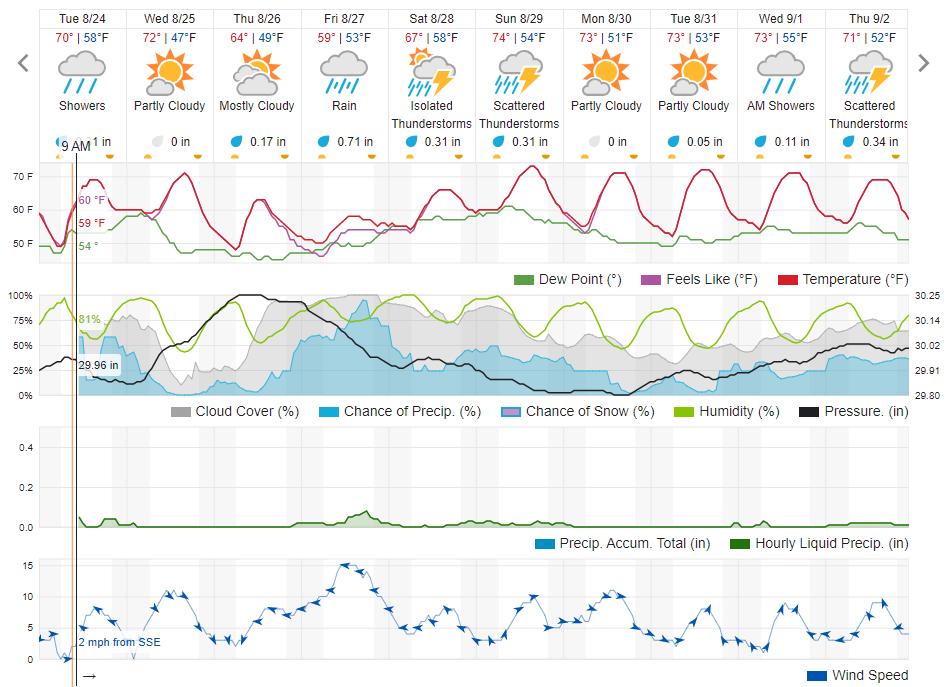
08/24/2021 10:25AM
Pinetree: "PJ: "LindenTree: "I'm workig off my tablet in Detroit Lakes instead of my computer in Duluth so I am not sure if I can post some links.
It appears from CalTopo that the Greenwood fire doubled in size yesterday. It burned all around McDougall Lakes and marched eastward and was south of the Knotted Pine this morning at 02:00 MDT. Guessing it is in the area of 15,000 acres now.
Also from CalTopo it looks like there is a good chance the canadian fires jumped the border in the Curtian Falls area. There is what appears to be heat signatures on the US side. I do not know if this has been confirmed.
John Ek fire was estimated to be in the 3,000 acre range from the USFS.
CalTopo did not load for northern MN. If you click on the link and minimize to MN and load fire activity on the right side toggles you can see the fires. Sorry.
CalTopo Greenwood fire "
That's a nice map to play around with.
Is there a fire in Superior, WI?
The Quetico fires have been burning for a while. How come they have not grown in size like Greenwood and John Ek?"
They have and they are bigger"

Not compared to Greenwood.
The purpose of the journey is not to arrive.
08/24/2021 10:37AM
PJ: "
That's a nice map to play around with.
Is there a fire in Superior, WI?
The Quetico fires have been burning for a while. How come they have not grown in size like Greenwood and John Ek?"
It is probabaly picking up heat signatures form the Husky Plant, it will also pick up heat signatures from the Iron Ore plants sometimes.
As someone aslo mentioned the fires in Quetico are much larger than the ones in the arrowhead, MODIS does not show fire perimeters just recent heat. If a fire cools down it will not pick it up, you can go back in time and see previous heat signatures if you know how to do it.
May the rivers be crooked and winding, and your portages lonesome, leading to the most amazing view.
08/24/2021 11:25AM
LindenTree: "PJ: "
That's a nice map to play around with.
Is there a fire in Superior, WI?
The Quetico fires have been burning for a while. How come they have not grown in size like Greenwood and John Ek?"
It is probabaly picking up heat signatures form the Husky Plant, it will also pick up heat signatures from the Iron Ore plants sometimes.
As someone aslo mentioned the fires in Quetico are much larger than the ones in the arrowhead, MODIS does not show fire perimeters just recent heat. If a fire cools down it will not pick it up, you can go back in time and see previous heat signatures if you know how to do it."
Makes sense...thanks for the education.
The purpose of the journey is not to arrive.

08/24/2021 01:09PM
cyclones30: "Today's estimate is Greenwood is basically 20k acres. They've pulled some crews for safety sake. Hopefully the weather will turn because I don't think humans are going to put a dent in it at this rate "
Has anyone heard if any building were lost-sure hope not.
Much of the Greenwood fire is at the north end of what they call the 100 mile swamp. Lot of high ground but gives you a idea there is so much balsam and spruce in that area and low land. More swampto the southeast area of the fire. It is one very good area for moose and good grouse hunting. Wild country.

08/24/2021 01:29PM
Has anyone heard if any building were lost-sure hope not.
There is a YouTube video just posted called “Advancing Greenwood Fire captured advancing on home”
I’m not sure if the home made it or not but the security camera captured some amazing footage of trees catching fire. Hope it came through. Thoughts to all involved.
There is a YouTube video just posted called “Advancing Greenwood Fire captured advancing on home”
I’m not sure if the home made it or not but the security camera captured some amazing footage of trees catching fire. Hope it came through. Thoughts to all involved.
08/24/2021 01:46PM
Zulu: "Has anyone heard if any building were lost-sure hope not.
There is a YouTube video just posted called “Advancing Greenwood Fire captured advancing on home”
I’m not sure if the home made it or not but the security camera captured some amazing footage of trees catching fire. Hope it came through. Thoughts to all involved."
That video was very intense.
"In wilderness is the salvation of mankind." Thoreau.
08/24/2021 02:21PM
LindenTree: "Near as I can tell there was little to no rain today."
Read it and weep. "You don't need to be a weatherman" to interpolate the likely amounts in the interior of Lake County since Aug. 1 and in the last 24 hours, given the data from the surrounding stations:


08/24/2021 02:34PM
Any rain is good, but these .1 or .2 inches of rain aren't gonna help. The deep soil moisture needs to be replenished. And that's going to take a lot of rain. Days and days of steady moderate rain.
What seems to be happening now is any rain that approaches the extremely dry air soaks up any moisture and it never reaches the ground.
Hopefully as the seasons change a pattern change will take place and areas that need the moisture will receive it.
What seems to be happening now is any rain that approaches the extremely dry air soaks up any moisture and it never reaches the ground.
Hopefully as the seasons change a pattern change will take place and areas that need the moisture will receive it.
"In wilderness is the salvation of mankind." Thoreau.
08/24/2021 03:59PM
gravelroad: "LindenTree: "Near as I can tell there was little to no rain today."
Read it and weep. "You don't need to be a weatherman" to interpolate the likely amounts in the interior of Lake County since Aug. 1 and in the last 24 hours, given the data from the surrounding stations:

"
For the 08/24/21 - I'm looking at a dot that 0.00 that's pretty much on top of my house and everything was wet this morning and it was raining when I left for work, it rained all the way in and was raining at my work when i arrived. At some point it quit and I don't have any idea how much it was, but the road was still wet when I went to lunch. I don't know if it rained north at the fire, and if it did...it likely wasn't enough to do any real help.
"Fool me once, shame on...shame on you. Fool me, can't get fooled again" - W
08/24/2021 05:25PM
Speckled:
For the 08/24/21 - I'm looking at a dot that 0.00 that's pretty much on top of my house and everything was wet this morning and it was raining when I left for work, it rained all the way in and was raining at my work when i arrived. At some point it quit and I don't have any idea how much it was, but the road was still wet when I went to lunch. I don't know if it rained north at the fire, and if it did...it likely wasn't enough to do any real help.
"
I do not know what to tell you, the ELY Raws/Remote Area Weather Station still shows 0.0 guess you got lucky, and the rain was very isloated, you must be a little ways from the RAWS.
Play around with this precipitation link, zoom into the arrowhead of MN. On the left, toggle the RAWS, refresh map, click on your weather station and click on Precip. It will let you into the most recent weather going back around 36 hours.
It also shows many more weather observations than the airports do, it will show the Meander and Fernberg RAWS up by the Canadian border near the fires in Canada.
Airports and RAWS weather stations in the US.
May the rivers be crooked and winding, and your portages lonesome, leading to the most amazing view.
08/24/2021 05:41PM
"Hopefully the weather will turn because I don't think humans are going to put a dent in it at this rate"
With full recognition that NE MN is not the West, I'll note that's the reality of most big fires out here. Despite heroic - and expensive - efforts it's almost always weather that puts out the biggest fires (or at least gives us a chance).
After decades of fire suppression (it's much easier to put the small fires out) and in the age of climate change, I suspect that's becoming true in many more places.
Saving homes, lives, and infrastructure can be a different story.
Hoping you get good rain soon. And plenty of it!
08/24/2021 06:02PM
LindenTree: "Speckled:
For the 08/24/21 - I'm looking at a dot that 0.00 that's pretty much on top of my house and everything was wet this morning and it was raining when I left for work, it rained all the way in and was raining at my work when i arrived. At some point it quit and I don't have any idea how much it was, but the road was still wet when I went to lunch. I don't know if it rained north at the fire, and if it did...it likely wasn't enough to do any real help.
"
I do not know what to tell you, the ELY Raws/Remote Area Weather Station still shows 0.0 guess you got lucky, and the rain was very isloated, you must be a little ways from the RAWS.
Play around with this precipitation link, zoom into the arrowhead of MN. On the left, toggle the RAWS, refresh map, click on your weather station and click on Precip. It will let you into the most recent weather going back around 36 hours.
It also shows many more weather observations than the airports do, it will show the Meander and Fernberg RAWS up by the Canadian border near the fires in Canada.
Airports and RAWS weather stations in the US. "
To this point, I'm not surprised that the CoCoRaHS data doesn't match the observation for the day. From my experience, CoCoRaHS data is generated by civilian scientists. The power of that network is how cost effective and expansive it can be. You have to trade something, though, and in this case it is usually temporal data resolution and quality.
08/24/2021 06:29PM
I think we are saying the same thing. You pretty much hit my definition of civilian science.
Point being, the MODIS data is some of the most studied terrestrial satellite data around. Heavily scrutinzed, by and large accurate - I'm sticking to that for tracking. Don't know about you, but I haven't seen an accurate "weather" forecast or history in years... unless it's raining and I'm in my yard.
Point being, the MODIS data is some of the most studied terrestrial satellite data around. Heavily scrutinzed, by and large accurate - I'm sticking to that for tracking. Don't know about you, but I haven't seen an accurate "weather" forecast or history in years... unless it's raining and I'm in my yard.
08/24/2021 07:43PM
Northwoodsman: "Several new fires popped up on inciweb today: Fourtown (been active since 7/25), Steep (detected on 8/20), Petit, Gabi, Rice Bay, and Second Bay."
Are you talking 2nd bay off sag to the west
..on the way to swamp and ottertrack and monument portage?
08/24/2021 09:06PM
Mocha: "Northwoodsman: "Several new fires popped up on inciweb today: Fourtown (been active since 7/25), Steep (detected on 8/20), Petit, Gabi, Rice Bay, and Second Bay."
Are you talking 2nd bay off sag to the west
..on the way to swamp and ottertrack and monument portage?"
No...doesn't look like there's one there
08/24/2021 09:54PM
cyclones30: "Same thing with the "fires" along the Mississippi R between the quad cities and Muscatine in IA. A very large steel plant and a very large quarry/minerals/asphalt plant. "
Very OT: are you a QC native, by chance?
"Let us think the unthinkable, let us do the undoable, let us prepare to grapple with the ineffable itself, and see if we may not eff it after all."
08/25/2021 04:32AM
BasswoodFan: "Received an email tonight saying my permit for the week of 9/4 was not cancelled but the area is still closed so there is a possibility it could be cancelled. Not new news and not unexpected but thought I would share."
Basswood - I had a entry permit for Snake River for Sunday 8/29/21. I received an email from the forest service on 8/17 alerting me, "Your reservation is located in an area of the BWCAW that is currently under a closure order due to wildfire activity. Your reservation has not been cancelled. However, there is the potential that your permit could be cancelled as conditions change."
I received a 2nd email from the forest service 8/21/21 with the same message.
Yesterday afternoon 8/24/21 I received another email from Forest Service stating, "A full refund has been processed for your BWCAW permit reservation due to wildfires in the BWCAW and on the U.S. – Canadian border.....". Within an hour of this message, I had three new ones from RECREATION.GOV updating me on the status of my refund.
With all of the fires and craziness going-on up there right now, I am most impressed with the Forest Service still doing an excellent job keeping permit holders informed and updated in a timely manner.
08/25/2021 05:39AM
BasswoodFan: "Received an email tonight saying my permit for the week of 9/4 was not cancelled but the area is still closed so there is a possibility it could be cancelled. Not new news and not unexpected but thought I would share."
Received same re 9/8 entry. On the permit site, there was a message saying BWCA is closed through 9/30. So the messaging seems out of sync. But belief is that it is over for this season.
08/25/2021 08:04AM
Mocha: "Northwoodsman: "Several new fires popped up on inciweb today: Fourtown (been active since 7/25), Steep (detected on 8/20), Petit, Gabi, Rice Bay, and Second Bay."
Are you talking 2nd bay off sag to the west
..on the way to swamp and ottertrack and monument portage?"
Sorry Mocha, yes that was a typo, it's called Second Creek. I corrected it in my earlier post. Thanks for letting me know.


08/25/2021 05:51PM
Good update yesterday from Sawbill Outfitters on the John Ek and Whelp Fires plus a new one near Crescent Lk:
"The Whelp Fire miraculously showed very little growth over the last few days. It remains at about 50-60 acres. The John Ek fire grew to about 1500 acres, mostly to the east and northeast. There were some new fire starts, the only one near us was about a mile north of Crescent Lake just across the border of the BWCA, it is being called the Petit Fire. It is currently under an acre in size and has a fire crew actively working to contain it. Thankfully, it is in a very accessible area and they anticipate having it contained very quickly.
We continue to be in a safe position, with no evacuation orders imminent. We had a brief 12 hour period, from late last night until this afternoon, of bad smoke from the Greenwood fire. The winds have shifted and thankfully we had clear skies this evening. "
Want to make God laugh? Tell him your plans...
08/25/2021 06:59PM
WOW! Really smoky on the Gunflint Trail at Seagull Outfitters and Gunflint Outfitters.
Tomster
Gunflint Trail Smoke Gunflint Trail Smoke
Tomster
Gunflint Trail Smoke Gunflint Trail Smoke
08/26/2021 10:43AM
From InciWeb:
Greenwood Fire Update-August 26, 2021
Greenwood Fire Wildfire
News – 7 min. ago
Community Meeting Today at 6 p.m. at the Wolf Ridge Environmental Learning Center, 6282 Cranberry Rd, Finland, MN.
Yesterday: Taking advantage of northwest winds, crews initiated defensive firing operations along Hwy 1 and the Jackpot Lake Road to better secure fire boundaries. Fuels were reduced around cabins and other structures to protect them. A firing operation was also initiated along Hwy 2 at the southwest end of the fire. Heavy machinery was used construct a fire line along the part of the fire to the west of Hwy 2 (northwest). The fire was active in the southern portion. It is now estimated as 25,991 acres. Today and Tonight: Today’s priority is to hold and improve after yesterday’s firing operations, with the support of air resources, engines, bulldozers and other equipment, to reduce the burnable natural fuels near homes or near the edge of the fire. Crews will strengthen containment lines and continue building firelines where feasible. A total of 476 personnel are working on the fire, including cooperators and contractors. A new location for the Incident Command Post is being evaluated.
WEATHER/FIRE BEHAVIOR: Weather today will be cooler with mostly cloudy skies and higher relative humidity.
SUMMARY: Started by lightning,the Greenwood Fire was detected on August 15, 2021, around 3 p.m. on the Laurentian Ranger District. Generally, the fire is between Greenwood Lake and the intersections of Highways 1 and 2. The communities of Ely, Babbitt, Finland, Toimi-Brimson and along the North Shore are not threatened by this fire. The objective of fire management is full suppression using all available resources. The fire continues to threaten cabins, homes, and recreational sites. Twelve primary structures and 57 outbuildings were destroyed August 23. Owners have been contacted by the Sheriff.
08/26/2021 11:36AM
Pinetree: "Looks like rain coming in a couple of hours."
- Also wind shift to the East (I think this is good? pushes the fire back upon itself?
- Also a steady rise in RH, which is forecast (according to Wunderground) to stay at 70% or higher from this afternoon through Sunday afternoon.
Hope all this helps the firefighters slow down and start containing both the Greenwood and John Ek fires.
"In wilderness is the preservation of the world" - Henry David Thoreau
08/26/2021 12:11PM
Cricket67: "Pinetree: "Looks like rain coming in a couple of hours."
- Also wind shift to the East (I think this is good? pushes the fire back upon itself?
- Also a steady rise in RH, which is forecast (according to Wunderground) to stay at 70% or higher from this afternoon through Sunday afternoon.
Hope all this helps the firefighters slow down and start containing both the Greenwood and John Ek fires. "
I forget who but someone has beenposting this nonsense about “pushing the fire back onto itself” but it doesn’t work that way. If the wind switches to the east, then the back of the fire will become the front of the fire, and will now spread to the west.
What’s more important is the temp and humidity. East winds usually mean damp and cool and the fire will just smolder until the humidity goes down and the temp goes up.
08/26/2021 12:23PM
But as the press release says...they are burning the fire back into itself with the controlled burns ahead of it. Using the N and NW winds to burn ahead of the leading edge back into the fire. Map showed where they were doing all those
Sounds like plenty of structures lost and already a big area but...even at 0% contained they seem to have some measure of grip on areas
Sounds like plenty of structures lost and already a big area but...even at 0% contained they seem to have some measure of grip on areas
08/26/2021 01:47PM
cyclones30: "But as the press release says...they are burning the fire back into itself with the controlled burns ahead of it. Using the N and NW winds to burn ahead of the leading edge back into the fire. Map showed where they were doing all those
"
Sounds like they are buring out the fires edge and bringing it to hwy 2 on the west side and Hwy 1 on the north end. With the right winds this is very doable, we used to do it all the time.
The trick will be catching it on the east side, I heard mention that they may use the Stoney River forest grade as a fire break from hwy 1 down south to the powerline which follows the old RR tracks. This wil be a tough one if they burn out this area since it is so large, however it may be their only chance to catch this flank. Going direct in the swampy heavy woods will be challanging, if it is even doable in these drought conditions.
May the rivers be crooked and winding, and your portages lonesome, leading to the most amazing view.
08/26/2021 02:04PM
Radar shows some light rain in Ely and the tracks are going SW to NE right across most of the BWCA. Here's hoping for a little relief for them. Fingers crossed it's not much wind or lightning and lots of precipitation.
Time in the woods leaves no time for carving and drawing. Carving and drawing leaves no time for getting lost in the woods. I really need to retire.

08/26/2021 03:05PM
LindenTree: "cyclones30: "But as the press release says...they are burning the fire back into itself with the controlled burns ahead of it. Using the N and NW winds to burn ahead of the leading edge back into the fire. Map showed where they were doing all those
"
Sounds like they are buring out the fires edge and bringing it to hwy 2 on the west side and Hwy 1 on the north end. With the right winds this is very doable, we used to do it all the time.
The trick will be catching it on the east side, I heard mention that they may use the Stoney River forest grade as a fire break from hwy 1 down south to the powerline which follows the old RR tracks. This wil be a tough one if they burn out this area since it is so large, however it may be their only chance to catch this flank. Going direct in the swampy heavy woods will be challanging, if it is even doable in these drought conditions."
Hey Linden, one thing I was curious about was the PIO map shows dozer
Line on the highway 2 side north of the LTV tracks up to the logging road. Then in the update yesterday they said they burned it out to highway 2. I wonder why? They must not have trusted that dozer line? I know Brian said on Monday that it was a problem because it was so dry. Not really sure why. I know there’s a cabin in there.
08/26/2021 03:22PM
marsonite:
Hey Linden, one thing I was curious about was the PIO map shows dozer
Line on the highway 2 side north of the LTV tracks up to the logging road. Then in the update yesterday they said they burned it out to highway 2. I wonder why? They must not have trusted that dozer line? I know Brian said on Monday that it was a problem because it was so dry. Not really sure why. I know there’s a cabin in there. "
Marsonite, I saw that too. I really would only be speculating as to why they did not hold it at the dozer line, you maybe right that they did not trust that dozer line. Personallly I would rather hold it on hwy 2 than rely on a skinny dozer line with burnable fuels right on the west side of the line. Hwy 2 would be a far safer bet. We have burned around houses my entire career that were within the foot print of a fire.
I was kinda suprised they put that dozer line in there in the first place. I have 2nd guessed Incident Commanders and Ops section cheifs my whole career, it never did any of us much good.
Edit, one other scenario is that the land owner would not let them burn out his land so they went around it. I don't know the legalities of not letting firefighting crews on private land to fight a fire.
I know at least 3 times in my career, probabaly more where the land owner told me I was not allowed on his property to fight a fire. I usually threatned to call law enforcement and they had a change of heart, perhaps this land owner had a change of heart.
One time I wanted to burn out about 5 acres in Montana and bring the fire line into the grass on private land rather than putting fire line in the timber. That rancher told me I was not going to burn out his land. I did not argue, he was carrying a pistol.
May the rivers be crooked and winding, and your portages lonesome, leading to the most amazing view.
08/26/2021 04:22PM
LindenTree: "marsonite:
Hey Linden, one thing I was curious about was the PIO map shows dozer
Line on the highway 2 side north of the LTV tracks up to the logging road. Then in the update yesterday they said they burned it out to highway 2. I wonder why? They must not have trusted that dozer line? I know Brian said on Monday that it was a problem because it was so dry. Not really sure why. I know there’s a cabin in there. "
Marsonite, I saw that too. I really would only be speculating as to why they did not hold it at the dozer line, you maybe right that they did not trust that dozer line. Personallly I would rather hold it on hwy 2 than rely on a skinny dozer line with burnable fuels right on the west side of the line. Hwy 2 would be a far safer bet. We have burned around houses my entire career that were within the foot print of a fire.
I was kinda suprised they put that dozer line in there in the first place. I have 2nd guessed Incident Commanders and Ops section cheifs my whole career, it never did any of us much good.
Edit, one other scenario is that the land owner would not let them burn out his land so they went around it. I don't know the legalities of not letting firefighting crews on private land to fight a fire.
I know at least 3 times in my career, probabaly more where the land owner told me I was not allowed on his property to fight a fire. I usually threatned to call law enforcement and they had a change of heart, perhaps this land owner had a change of heart.
One time I wanted to burn out about 5 acres in Montana and bring the fire line into the grass on private land rather than putting fire line in the timber. That rancher told me I was not going to burn out his land. I did not argue, he was carrying a pistol."
Thanks. I didn’t mean to sound like I was Monday quarterbacking. These guys do this for a living and mistakes and errors if judgement happen to every one of us. Just more noticeable in some cases.
The whole private land thing was something I was wondering about. I knew right away that this was going to burning on the Hayes Property. In fact I was hoping it would be an asset to have a network of roads and slashings…I guess is was just too stinking dry. But anyway, do they have to get permission to build fire lines? I know during the last Sand Lake fire 5 years ago they called the owner and asked permission to build dozer line on his property. But They mowed down a bunch of trees with a Bombadier on my place but never asked…not that I minded or would have said no.
Really curious what I find when I get up there. My land is just north of the division break on the east side of highway 2 across from the Sand Lake access and they said they were building direct line there with heavy equipment. Really not sure how far back the fire is.
08/26/2021 04:56PM
marsonite:
The whole private land thing was something I was wondering about. I knew right away that this was going to burning on the Hayes Property. In fact I was hoping it would be an asset to have a network of roads and slashings…I guess is was just too stinking dry. But anyway, do they have to get permission to build fire lines? I know during the last Sand Lake fire 5 years ago they called the owner and asked permission to build dozer line on his property. But They mowed down a bunch of trees with a Bombadier on my place but never asked…not that I minded or would have said no.
Really curious what I find when I get up there. My land is just north of the division break on the east side of highway 2 across from the Sand Lake access and they said they were building direct line there with heavy equipment. Really not sure how far back the fire is.
"
Marsonite, I have a few "Mostly" answers to your questions, and I will respond more tomorrow. In the mean time if you want to Google the MN Wildfire Act (Or something similiar) in MN state statutes, it may answer your questions about firefighting and private land. (Not Sure)
May the rivers be crooked and winding, and your portages lonesome, leading to the most amazing view.
08/26/2021 05:02PM
Not sure if the laws are the same in our 2 states but out here we have the right to go on private property as long as we are working a going fire. If we are putting in indirect line, we usually use topography or natural barriers to locate the best place to put in line. In this case we have cut fences used ranch roads ranch ponds or what ever to get the job done. The one thing I have done many times in the past is locate dozer line in a manner so we won't burn hundreds of acres of ranch graze land.
One thing we have problems once in a while, is using ranch lakes and ponds to dip water from for helicopter bucket drops. We have had ranchers threaten to shot down a copter if they takes more water! That is usually taken care of by the sheriff. Because water is such an issue here, we will replace the amount of water we use by hauling it in with water tenders. The picture is water taken from our ranch lake.
Hope your weather changes for the better!!
One thing we have problems once in a while, is using ranch lakes and ponds to dip water from for helicopter bucket drops. We have had ranchers threaten to shot down a copter if they takes more water! That is usually taken care of by the sheriff. Because water is such an issue here, we will replace the amount of water we use by hauling it in with water tenders. The picture is water taken from our ranch lake.

Hope your weather changes for the better!!
08/26/2021 07:48PM
TechnoScout: "Been monitoring radar...looks like BWCA got some rain today and into this evening. Cannot tell from the scan whether it is a little or a lot...but some!"
Looks like another couple of tenths , isolated 1/2" amounts
Twin Cities is getting pounded right now. Time from is from 3:30 am to 7:45pm today.

The two loudest sounds known to man: a gun that goes bang when it is supposed to go click and a gun that goes click when it is supposed to go bang.
08/27/2021 09:25AM
jwmiller39: "Northwoodsman: "The Greenwood fire is now estimated to be 100% contained by Sept. 10."
Source? Pretty bold statement for a 25k acre fire that is 0% contained"
That is the first thing I thought. They must be counting the favorable weather reports. I hope that they are right.
08/27/2021 09:46AM
MHS67: "Not sure if the laws are the same in our 2 states but out here we have the right to go on private property as long as we are working a going fire. "
Looks to be the same in Minnesota.
88.10 AUTHORITY OF STATE FOREST OFFICERS.
Subdivision 1.General authority. Under the direction of the commissioner, forest officers are charged with preventing and extinguishing wildfires in their respective districts and the performance of such other duties as may be required by the commissioner. They may arrest without warrant any person found violating any provisions of sections 88.03 to 88.22, take the person before a court of competent jurisdiction in the county charging the person so arrested, and the person so charged shall be arraigned and given a hearing on the complaint. The forest officers shall not be liable in civil action for trespass committed in the discharge of their duties. All authorized state forest officers, fire wardens, conservation officers, smoke chasers, fire supervisors or individuals legally employed as firefighters, may in the performance of their duties of firefighting go onto the property of any person, company, or corporation and in so doing may set backfires, dig or plow trenches, cut timber for clearing fire lines, dig water holes, remove fence wires to provide access to the fire or carry on all other customary activities necessary for the fighting of wildfires without incurring a liability to anyone, except for damages arising out of willful or gross negligence.
May the rivers be crooked and winding, and your portages lonesome, leading to the most amazing view.
08/27/2021 10:00AM
jwmiller39: "Northwoodsman: "The Greenwood fire is now estimated to be 100% contained by Sept. 10."
Source? Pretty bold statement for a 25k acre fire that is 0% contained"
The source I saw was from the National Fire Situation Report. They bumped the containment date back to the Sept 10th, it had been Sept 1st a few days ago. I too would be suprised if it is contained by Sept 10th.
May the rivers be crooked and winding, and your portages lonesome, leading to the most amazing view.
08/27/2021 11:06AM
With the rain down here in the Twin Cities came a strong burnt smell. I talked to my sister up in Brainerd and she commented the same. I do hope the northern part of the state and Quetico felt a little relief.
Time in the woods leaves no time for carving and drawing. Carving and drawing leaves no time for getting lost in the woods. I really need to retire.
08/27/2021 12:01PM
LindenTree: "jwmiller39: "Northwoodsman: "The Greenwood fire is now estimated to be 100% contained by Sept. 10."
Source? Pretty bold statement for a 25k acre fire that is 0% contained"
The source I saw was from the National Fire Situation Report. They bumped the containment date back to the Sept 10th, it had been Sept 1st a few days ago. I too would be suprised if it is contained by Sept 10th."
Meanwhile, on inciweb's Greenwood update today:
"Projected Incident Activity
12 hours:
High RH, clouds, and scattered showers will moderate any fire spread. Still plenty of remaining heat in heavy fuels.
24 hours:
Forecast for clouds, higher RH, and chance of showers should moderate fire behavior. However, large areas of uncontained fire line and dry heavy fuels holding heat will remain.
48 hours:
Forecast for clouds, higher RH and chance of showers should suppress fire spread.
72 hours:
Winds pick up again, with a drying trend may awaken the large areas of heat still remaining from large fire growth days. Convoluted fire line makes location of containment lines difficult and leaves unburned fuels available.
Anticipated after 72 hours:
Warming, drying trend and areas of holdover heat requires vigilance and persistence to prevent fire growth."
Hard to say with any certainty what 2 weeks from now will bring, no?
"You can observe a lot just by watching." -- Yogi Berra
08/27/2021 08:07PM
I began fighting fire for the Forest Service in 1958. In 1988, after what happened in Yellowstone, I figured that it was time to check out. I have not been on a fire for thirty three years so that I have no idea as to what is going on except for observing short clips on TV. Clip after clip shows firefighters , most often in clean shirts, not having any idea of how to use water. Do they no longer instruct basic fundamentals?
08/27/2021 08:43PM
smoke: "I began fighting fire for the Forest Service in 1958. In 1988, after what happened in Yellowstone, I figured that it was time to check out. I have not been on a fire for thirty three years so that I have no idea as to what is going on except for observing short clips on TV. Clip after clip shows firefighters , most often in clean shirts, not having any idea of how to use water. Do they no longer instruct basic fundamentals?"
That's quite a career smoke, thanks for your years of service. I have been retired for 20 years. The one thing I've noticed over the years is very little has changed on the fire line. You still do hose lays, cut handline, use dozers and aircraft, etc. The one thing I think has changed is the peoples work ethic. Years ago most of the kids we hired were ranch kids. They knew how to work! Today, if you have one ranch kid on your crew you are lucky.
Short story! I was off duty and had a question for my partner at work. We just got 4 brand new firefighters that same day. After we talked business I asked him how the new crew looked. His answer, " I'm teaching them which end of the broom goes on the floor"!!
08/27/2021 08:45PM
Well, now it has happened! The DNR has just closed the whole Superior National Forest to even backcountry (or also called dispersed) camping/canoe trips.
Only camping can be at official campgrounds.
Campgrounds near Ely Minnesota
https://www.recreation.gov/camping/campgrounds/233840
Fenske Lake Campground Link
https://www.recreation.gov/camping/campgrounds/232283
Fall Lake Campground Link
https://www.recreation.gov/camping/campgrounds/233843
South Kawishiwi Campground Link
https://www.recreation.gov/camping/campgrounds/233841
Birch Lake Campground
08/27/2021 08:46PM
I worked on fires in Idaho while in college during the 1970's. Looks like a lot of things have changed since then. The only water we had to fight fire was from what we called piss pumps that we carried on our backs. Never once heard a fire boss say our safety was most important. We just knew it was up to us to stay safe.
Want to make God laugh? Tell him your plans...
08/27/2021 08:49PM
All the fires reported on Inciweb have an estimated date of containment (containment is when there is fire line around the whole fire, not when the fire is actually out.) For example, the 750,000 acre Dixie fire is supposed to be contained on September 30 at 12 AM. I'm sure part of the reason for estimating containment is that it provides data for people planning on a regional or national level. Obviously things can go wrong.
08/28/2021 06:20AM
VoyageurNorth: "Well, now it has happened! The DNR has just closed the whole Superior National Forest to even backcountry (or also called dispersed) camping/canoe trips.
"
Do you blame them? It is scary dry out there.
The purpose of the journey is not to arrive.
08/28/2021 06:47AM
smoke: "I began fighting fire for the Forest Service in 1958. In 1988, after what happened in Yellowstone, I figured that it was time to check out. I have not been on a fire for thirty three years so that I have no idea as to what is going on except for observing short clips on TV. Clip after clip shows firefighters , most often in clean shirts, not having any idea of how to use water. Do they no longer instruct basic fundamentals?"
I’m sure the hundreds of firefighters working on the ground would not agree with you.
I know I disagree with you.
Based on the current weather and the weekend forecast, I would say things are going to take a turn for the better. Lots of moisture, fog, rain I don’t know if any restrictions or closures will change but you certainly can’t burn anything today. Too soggy!
Tom
08/28/2021 07:38AM
tumblehome: "Based on the current weather and the weekend forecast, I would say things are going to take a turn for the better. Lots of moisture, fog, rain I don’t know if any restrictions or closures will change but you certainly can’t burn anything today. Too soggy!
Tom"
The soggy conditions are what surprised me about yesterday's closure of everything other than campgrounds. I'll be the first to admit I know next to nothing about fighting forest fires - so let me preface by saying that I'm not really questioning the order and I am immensely grateful to the teams of people that are out there protecting homes and the places we love.
That said, I'm trying to understand what prompted the added closure yesterday. By all accounts, the conditions did not lead to a worsening of the fires yesterday, and aren't projected to get worse in the near future either. So why were they closed yesterday? Most non-wilderness sites are reasonably quick to evacuate if necessary right? I haven't spent much time in the SNF outside the BWCA. Please don't flame me, but if someone has insights to help me understand why the expanded closure makes sense that would be appreciated. :)
08/28/2021 08:36AM
Could the additional closures yesterday be because so many of the people that had planned on being in the BWCA have headed to the USFS campgrounds filling them up thus forcing more people in to the forest utilizing dispersed camping? When you are dispersed camping are you more likely to have an illegal campfire because you know a ranger won't be paddling by checking your permit and your activity? Is there more risk of a fire from people parking vehicles in tall dry grass? Is it because now the USFS has no idea where you could be, at least in the BWCA you were either going to be on a lake, river, stream, portage, or campsite; now you have people scattered throughout the forest? Is it because of the forecasted rains there is a chance of lightning and more fires popping up? I think it's a good idea to reduce the visitor population in the area altogether right now so the resources can be utilized stopping the spread of the fires, and for emergency situations that arise amongst the firefighters or the residents.
08/28/2021 09:47AM
MHS67: " Years ago most of the kids we hired were ranch kids. They knew how to work! Today, if you have one ranch kid on your crew you are lucky.
"
So true, in the late 90's I was the operations manager for the Miles City BLM fire district,
in eastern MT, which was huge probabaly 5 million acres of protection area. The best workers I served
with were the ranch kids, they could fix and drive anything. I had a couple girls who were raised on ranches, they were double tough, one was 5'2" at best and was the assistant engine captian of one of my heavy engines. A type 4 engine, that requires a CDL. We are still not sure how her feet reached the clutch pedal. The Smoke Jumpers called her "Two Star" because her feet were so small that her White's fire Boots could only have two stars on the bottom tread.
May the rivers be crooked and winding, and your portages lonesome, leading to the most amazing view.
08/28/2021 09:55AM
quote>Northwoodsman: "Could the additional closures yesterday be because so any of the people that had planned on being in the BWCA have headed to the USFS campgrounds filling them up thus forcing more people in to the forest utilizing dispersed camping? When you are dispersed camping are you more likely to have an illegal campfire because you know a ranger won't be paddling by checking your permit and your activity? Is there more risk of a fire from people parking vehicles in tall dry grass? Is it because now the USFS has no idea where you could be, at least in the BWCA you were either going to be on a lake, river, stream, portage, or campsite; no you have people scattered throughout the forest? Is it because of the forecasted rains there is a chance of lightning and more fires popping up? I think it's a good idea to reduce the visitor population in the area altogether right now so the resources can be utilized stopping the spread of the fires, and for emergency situations that arise amongst the firefighters or the residents."
All very good questions/reasons for the action.
The purpose of the journey is not to arrive.
08/28/2021 11:16AM
Thanks for the reply with ideas Northwoods. Many of you online have a lot of great perspective to share and I value the community’s insights. So please read my comments below with a tone of discussion to seek understanding, rather than an argumentative “I just want to camp” tone that the written word could result in. I’m most definitely not trying to argue!
Your points about dispersed camping make sense. I agree that in many ways dispersed is worse since, as you mentioned, nobody knows where you are. I wasn’t really thinking about dispersed camping in my original question so the point was well-made.
I still wonder about the remote campsites on lakes that aren’t in the wilderness. Those established sites that aren’t near current fires seem like they could easily remain open since their location is defined and pretty quick to check in the event of a fire - unless most forest rangers who would be responsible for notifying of evacuation orders are also firefighters or needed to support them directly? I’m not sure of their responsibilities toward the active fires. I agree resources shouldn’t be spread thin that can be used to fight the active fires.
I’m not sure I’m comfortable with closures that involve what-if scenarios about whether lightning starts a fire. That feels like precedent for future dry spells that are not as severe. I don’t want the forest service to default to closures in the future unless they are truly needed.
As an example, If someone wanted to setup on the campsite on Moss Lake off the gunflint right now, I don’t see anything that made this more risky today than 1 week ago. If anything, conditions and forecast are ever so slightly improved. If a new fire ignites over there, they are a short paddle out.
So it would have been nice if the forest service communicated why this increased closure across the entire region was necessary for the established campsites when it seemed the forecast was more favorable. I don’t mind following the advice and rules of experts, but when access to public lands is restricted I do prefer a more complete explanation of why than what was offered.
Make no mistake, I support doing whatever is needed to maximize safety of firefighters and citizens. I’d just like to understand more about these blanket orders that impact lands far away from active fires.
Hoping I don’t get destroyed here. Feel free to educate me politely. As I said, the most firefighting I’ve ever done is putting my campfire out until it was cold to touch. :)
08/28/2021 12:04PM
Not trying to stir the pot.
But last year and this year we have seen examples of people not following the rules. So I'm wondering if the USFS is taking that into consideration. Especially considering that the fire ban has been in place this year.
I could see the conversation going something like this,
"live trees cut, garbage everywhere, drones, unprepared campers needing rescue...do we think that if they can't follow the LNT rules they will follow the burn ban rule".
So they shut everything down.
But this could also just be my dimm view of some of the people that choose to camp in the BW.
"In wilderness is the salvation of mankind." Thoreau.
08/28/2021 12:49PM
Atikokan Progress
Yesterday at 11:24 AM ·
Fire service fighting Quetico blaze
Ontario’s forest fire service has stepped up efforts to contain the fires in Quetico Park.
The area got less rain than the rest of the district this week, and the fires within the Park doubled in size. They covered over 44,000 hectares Friday morning.
Spokesperson Chris Marchand said four crews were working the largest fire (Fort Frances 35, which has been burning since early June), with considerable air support (thus all the helicopter activity noticeable here).
As well three new fires were detected late Thursday in the Argo Lake area, and all received initial attack. Numerous fires are also burning in northern Minnesota. The Boundary Waters Canoe Area was closed to backcountry travellers on August 21.
Easterly winds meant Atikokan was spared the smoke that inundated town last week. Fort Frances and the west end of the district are experiencing heavy ssmoke conditions.

08/28/2021 04:55PM
airmorse: "Not trying to stir the pot.
"live trees cut, garbage everywhere, drones, unprepared campers needing rescue...do we think that if they can't follow the LNT rules they will follow the burn ban rule".
So they shut everything down.
But this could also just be my dimm view of some of the people that choose to camp in the BW."
I saw this last year. At this campsite lower limbs cut on many trees. Also a terribly scalped birch.

08/28/2021 05:00PM
Certainly no expert here. Look at a map of the area. A lot of places are one way in---one way out. If the area is closed and fire moves through the area then less possibility of average citizens being there. I would gather most people would rather not "run for their lives" as we've seen in parts of the west kinds of evacuations. Sure closing off wide swaths of public lands has it's issues and such action should have clarity and accountability. The capacity of the agencies that oversee said lands are no doubt diminished while staff and crews deal the the pressing matters of fires, recreational users, local property owners, and other needs of the area. Removing the recreational users at least takes out one part of of multiple equations. I can do other things while the fire rages on.
08/28/2021 05:15PM
A bunch of us should attend (via FaceBook Live) the next Greenwood and John Ek/Welp community meetings and ask the question: "Why was the entire forest closed?" Based on what I have seen watching these...they answer questions. Even tough ones.
The purpose of the journey is not to arrive.
08/28/2021 06:20PM
Pinetree: "Today could be the best rains all summer-a game changer?"
By noon Sunday the whole BW will have gotten a good soaking. It will be very interesting to see what effect it has on the fires. Next chance of rain is Thursday.
"Life is not about finding yourself. Life is about creating yourself." --- George Bernard Shaw
08/28/2021 06:39PM
PJ: "A bunch of us should attend (via FaceBook Live) the next Greenwood and John Ek/Welp community meetings and ask the question: "Why was the entire forest closed?" Based on what I have seen watching these...they answer questions. Even tough ones."
I'll bite the bait. As guided by the USDA, the USFS values life and property above wilderness. If you doubt that, then consider the 100k acre fire burning in Quetico, a conglomeration of fires that have started earlier this summer, and now threatens to cross into the BWCA.
There is a limit to the personnel and equipment. If they have to expend resources notifying and saving lives of a couple campers at Eighteen Lake, that means less resources for the protecting the items in the first paragraph. As far as "not so hard to reach", that is not true. Many of the remote sites are locating on winding, single-track roads, and take 30 minutes to go a few miles. Those are the well-known ones. Evacuation nightmare. Comparison to leaving burning California is inaccurate. The fellows that lit the fire on Clara Lake? That is (was) as sweet little spot known by few, now wrecked. Not only wrecked but expensive to control. The effort to contain that little island fire was intense and costly. They even set up a sprinkler system so that it wouldn't spread.
I fully support not only the closing of the BWCA, but of the forest. Unless you've been there in the past two weeks, you have no idea just how dry, dangerous and extreme the situation.
Let me kindly suggest that if a mob forms from this forum to attend the upcoming sessions, that it set aside any inkling of torches, flames or confrontation. The firefighters and their chiefs are exhausted, stretched to their physical and mental limits, and everyone is sincerely doing their best. Shut it down for now, stabilize the situation, and deal with the fact that this is our future.

08/28/2021 07:02PM
Prospector: "The Forest Service posted this photo of the Greenwood fire on the SF Twitter account. Does anyone know what kind of vehicle this is? Amphibious?

"
"One of the most unique pieces equipment in the wildland fire toolbox is an amphibious tractor known as a ‘Marsh Master’. This rugged but light piece of wildland machinery allows firefighters to move across wet areas where typical equipment would only be bogged down. A Marsh Master carries a tank of water and its own hose reels. In the photo attached to this post, fire fighters are lighting a tactical burn in the vicinity of the McDougal Lake Area. These implements are essential in working in environments where water or wetlands are frequently encountered."
From USFS FB post.
08/28/2021 07:20PM
PJ: "A bunch of us should attend (via FaceBook Live) the next Greenwood and John Ek/Welp community meetings and ask the question: "Why was the entire forest closed?" Based on what I have seen watching these...they answer questions. Even tough ones."
Obviously they were not aware that that decision may affect people's vacation. They were probably foolishly thinking abou
t public saftey.
08/28/2021 07:28PM
Great Melinko: "PJ: "A bunch of us should attend (via FaceBook Live) the next Greenwood and John Ek/Welp community meetings and ask the question: "Why was the entire forest closed?" Based on what I have seen watching these...they answer questions. Even tough ones."
Obviously they were not aware that that decision may affect people's vacation. They were probably foolishly thinking abou
t public saftey.
"
I jest, but really Public Saftey.
08/28/2021 08:58PM
I get public safety and limited resources. I just don't get what changed yesterday. The situation and forecast improved, and we received more restrictions. That is counterintuitive and I really wish they would explain it. Why was it safe to camp in a remote campsite on Thursday night and suddenly it is more dangerous now? I don't think there is an answer I'll love at this point, but I'm not bent out of shape enough grab a pitchfork and light a torch! :) I understand that people are doing the best they can in a difficult time and respect that the decisions are made with the best intentions.
I think I voiced this concern enough here and I hope it came off as respectfully as possible rather than as an argument. The absolute last thing I want would be to stir up a fight that locks or deletes this thread. I appreciate the insights and opinions offered, including those that differ from my own, and I'm praying for the safety of everyone involved in these fires, and for rain.
I think I voiced this concern enough here and I hope it came off as respectfully as possible rather than as an argument. The absolute last thing I want would be to stir up a fight that locks or deletes this thread. I appreciate the insights and opinions offered, including those that differ from my own, and I'm praying for the safety of everyone involved in these fires, and for rain.
08/29/2021 06:37AM
Fortunately for the welfare of the forum, I think things will change today. Northern MN received healthy rain this weekend. The Greenwood fire will probably be past tense this week except for some stubborn areas. I think the Quetico fires probably got soaked too.
I am looking at rain totals for MN and I see what looks like 12" in a few spots in southern MN? Can't be but that's what wether.gov shows. Brainerd finally got a soaking too. So much rain. Nice and steady and prolonged.
Tom
I am looking at rain totals for MN and I see what looks like 12" in a few spots in southern MN? Can't be but that's what wether.gov shows. Brainerd finally got a soaking too. So much rain. Nice and steady and prolonged.
Tom
08/29/2021 06:40AM
TomT: "Pinetree: "Today could be the best rains all summer-a game changer?"
By noon Sunday the whole BW will have gotten a good soaking. It will be very interesting to see what effect it has on the fires. Next chance of rain is Thursday. "
Yep, a good chunk of the Arrowhead be wet this morning, with more coming at the end of the week. (The interim? You don’t want to hear …)
Movement of this is to the northeast:

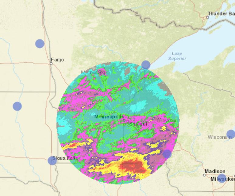
08/29/2021 06:50AM
tumblehome: "Fortunately for the welfare of the forum, I think things will change today. Northern MN received healthy rain this weekend. The Greenwood fire will probably be past tense this week except for some stubborn areas. I think the Quetico fires probably got soaked too.
I am looking at rain totals for MN and I see what looks like 12" in a few spots in southern MN? Can't be but that's what wether.gov shows. Brainerd finally got a soaking too. So much rain. Nice and steady and prolonged.
Tom"
There were constant soaking rains and thunderstorms rolling across the southern half of the state for the past 2 to 3 days. Yesterday was a wave-after-wave of precipitation. I haven't seen totals yet this AM but a 12" total wouldn't surprise me for areas south of the twin cities. It was a pounding!
"It is hard to fail, but it is worse never to have tried to succeed.”
08/29/2021 09:56AM
Pinetree: "Seen somewhere certain Mn DNR land is still open for day use. Trying to find that again."
From the Forest Service Facebook page, it looks like that will change on tomorrow: " Day use is allowed on the forest and most developed campgrounds (fee and non-fee) remain open to public use. Closure Order R9-09-21-15 available on the Forest website contains a list of open campgrounds. Forest officials made the decision to enact this closure in the interest of public safety as the forest continues to experience severe to extreme drought, high fire risk and multiple active fires. The Superior National Forest is coordinating with the State of Minnesota who will be implementing similar closures across the Arrowhead Region on August 30 due to the challenging natural resource conditions."
During one of the townhall meetings, an FS manager stated that the region is 8" - 16" below average rainfall, the conditions are the most severe in the 29 years they have been using the current drought rating system. They also stated it is highly likely that the forest will not be out of drought condition for another year.
The purpose of the journey is not to arrive.
08/29/2021 12:54PM
I read this article online so take it with a grain of salt. It discusses the need for more DC-10 aircraft in the nation's wildfire fighting arsenal. I don't know how accurate the numbers are or if the point is valid. It's interesting though.
"It is hard to fail, but it is worse never to have tried to succeed.”
08/29/2021 01:10PM
HighnDry: "I read this article online so take it with a grain of salt. It discusses the need for more DC-10 aircraft in the nation's wildfire fighting arsenal. I don't know how accurate the numbers are or if the point is valid. It's interesting though."
The more the better,but costs for the long run may be prohibitive. I have no idea the cost now but some of the big planes used over a decade ago cost $1700 per hour to fly than you have down time when you still have to pay.
No doubt,at least for now we need help, with over 3 million acres burnt this year nationwide.
08/29/2021 02:02PM
HighnDry: "tumblehome: "Fortunately for the welfare of the forum, I think things will change today. Northern MN received healthy rain this weekend. The Greenwood fire will probably be past tense this week except for some stubborn areas. I think the Quetico fires probably got soaked too.
I am looking at rain totals for MN and I see what looks like 12" in a few spots in southern MN? Can't be but that's what wether.gov shows. Brainerd finally got a soaking too. So much rain. Nice and steady and prolonged.
Tom"
There were constant soaking rains and thunderstorms rolling across the southern half of the state for the past 2 to 3 days. Yesterday was a wave-after-wave of precipitation. I haven't seen totals yet this AM but a 12" total wouldn't surprise me for areas south of the twin cities. It was a pounding!"
Average rainfall in my area was about 4 inches over a large area if south central and SE Mn
"I am haunted by waters"~Norman Maclean "A River Runs Through It"
08/29/2021 02:12PM
HighnDry: "I read this article online so take it with a grain of salt. It discusses the need for more DC-10 aircraft in the nation's wildfire fighting arsenal. I don't know how accurate the numbers are or if the point is valid. It's interesting though."The Forest Service just completed a nine year study, at a cost of 9million dollars, as to how effective retardant drops really are. The result of the study is "inconclusive." They are no longer allowed to salvo or get down on the deck and trench so that limits them a bit. I know that the old Hawkins and Powers piolets were told that they had a 1 in 40 chance of not returning.
08/29/2021 04:58PM
tumblehome: "Fortunately for the welfare of the forum, I think things will change today. Northern MN received healthy rain this weekend. The Greenwood fire will probably be past tense this week except for some stubborn areas. I think the Quetico fires probably got soaked too.
I am looking at rain totals for MN and I see what looks like 12" in a few spots in southern MN? Can't be but that's what wether.gov shows. Brainerd finally got a soaking too. So much rain. Nice and steady and prolonged.
Tom"
I don't have a rain gauge but in S. MN we did get a lot of rain the past couple of days. So much so that I might need to mow my lawn for the first time since ... June?
08/29/2021 06:17PM
PJ: "A bunch of us should attend (via FaceBook Live) the next Greenwood and John Ek/Welp community meetings and ask the question: "Why was the entire forest closed?" Based on what I have seen watching these...they answer questions. Even tough ones."
Why does it take a "bunch of us" to ask the question? Just post it in the comments section. If they don't get to it in the meeting they will most likely address it individually once the meeting ends?
08/29/2021 07:42PM
Just a little walk down memory lane.
I spent two weeks on the Pagami fire around Isabella Lake, right after the blow up.
During the first 3-4 days of my arrival on the Pagami Fire we got around 2 inches of rain on the fire. The rain kept it from making any big fire runs, but it did little to put it out.
This will be a long hard slog for all involved on the Greenwood fire, it could continue to burn a minimum of 4 weeks or more, maybe until the snow flie
May the rivers be crooked and winding, and your portages lonesome, leading to the most amazing view.
08/30/2021 05:54AM
Northwoodsman: "PJ: "A bunch of us should attend (via FaceBook Live) the next Greenwood and John Ek/Welp community meetings and ask the question: "Why was the entire forest closed?" Based on what I have seen watching these...they answer questions. Even tough ones."
Why does it take a "bunch of us" to ask the question? Just post it in the comments section. If they don't get to it in the meeting they will most likely address it individually once the meeting ends?"
Good idea. Do it.
The purpose of the journey is not to arrive.

08/30/2021 03:58PM
cyclones30: "Here's another marsh master picture at the Greenwood. Seems like a good way to get around in those parts. Local national wildlife refuge has one here in IA to get around all their marshes and wetlands
"
We have a Marsh Master on my old district in Detroit Lakes USFWS, I've driven it many times. They are made in Louisiana I believe. They make (Or used to make) 3 kinds, a MM1, 2 and 3. We had the MM2, it would hold 100 gallons of water in the pontoons with two people and still float. The tracks propel it in water, but it is best to have some purchase on the mud with the tracks, even if the mud is well under water. You can even get a mower attachment for them, Agassiz NWR had that attachment on theirs.
In open water the MM can only go a mile or two an hour at best, and is propelled by the tracks moving. If you get any type of wind and you do not have purchase with your tracks you will get blown across the lake.
We used ours mostly for putting in fire line across swamps and cattails. You make a pass or two with the MM, it crushes the cattails down and brings up water in the tracks. Then you light off that wet line and get away fast, cause those cattails burn hot.
Marsh Master website.
May the rivers be crooked and winding, and your portages lonesome, leading to the most amazing view.
08/31/2021 07:49AM
Here's what Sawbill Outfitters posted on their blog about the additional closures:
"Forest officials made the decision to enact this closure in the interest of public safety as the forest continues to experience severe to extreme drought, high fire risk and multiple active fires.
Closing camping outside of developed campgrounds reduces the possibility of the following:
* Search and rescue resources being diverted from firefighting operations.
* The need for emergency evacuations should additional wildfires occur.
* The chance of illegal campfires. Despite the current fire restrictions, there have been multiple reports of illegal campfires on the forest and several of those illegal campfires have caused small fires on the forest which divert resources away from priority fires. "
Last sentence is probably the key.
The purpose of the journey is not to arrive.
08/31/2021 08:06AM
Perhaps we can gain additional insight as to the SNF restrictions based on California just closing ALL of the National forests in the state. They did set a preliminary end date to the closures of 11:59 p.m. on 9/17. All good points below, I hadn't thought about the last one.
"Officials said they hope to reduce the number of people visiting national forests to prevent anyone from being trapped during an emergency such as a wildfire. Having fewer people on national forest lands also decreases the likelihood of new fires starting and will help keep firefighters and the community safer by limiting possible COVID-19 exposure, officials said."
"Officials said they hope to reduce the number of people visiting national forests to prevent anyone from being trapped during an emergency such as a wildfire. Having fewer people on national forest lands also decreases the likelihood of new fires starting and will help keep firefighters and the community safer by limiting possible COVID-19 exposure, officials said."
08/31/2021 04:37PM
cowdoc: "Whats the latest word on John Ek fire?"
From the USFS Superior NF Facebook page, In a nut shell the John EK fire remains unstaffed directly.
John Ek & Whelp Fire Update for 08/31/2021?
YESTERDAY: Recent rain along the Gunflint Trail moderated fire activity on the John Ek and Whelp fires. The John Ek Fire was remapped using infrared data and the size was reduced to 1,339 acres. The Whelp Fire remains at an estimated 50 acres. Last night, a community meeting was held at the Schaap Community Center and was well-attended by 100 people.
TODAY for the John Ek: Crews will continue work on improving portages to identify areas that will allow for safe access in and out, hose lays, and installation sites for sprinkler systems. Fireline locations are being identified at a safe distance from the fire that will allow crews to begin indirect fire suppression in the future. On the Whelp Fire: Air resources will be used today to monitor and suppress any fire activity.
May the rivers be crooked and winding, and your portages lonesome, leading to the most amazing view.
08/31/2021 06:10PM
PJ: "Northwoodsman: "PJ: "A bunch of us should attend (via FaceBook Live) the next Greenwood and John Ek/Welp community meetings and ask the question: "Why was the entire forest closed?" Based on what I have seen watching these...they answer questions. Even tough ones."
Why does it take a "bunch of us" to ask the question? Just post it in the comments section. If they don't get to it in the meeting they will most likely address it individually once the meeting ends?"
Good idea. Do it."
I posted the question... here is the answer: "To reduce additional risk of fires from illegal campfires and reduce risk of people being in remote areas where we can't find them should a fire arise." "They are constantly evaluating the situation on a daily basis and will open up areas as they see fit. Be on the lookout for news in coming days."
08/31/2021 06:12PM
"TODAY for the John Ek: Crews will continue work on improving portages to identify areas that will allow for safe access in and out, hose lays, and installation sites for sprinkler systems. Fireline locations are being identified at a safe distance from the fire that will allow crews to begin indirect fire suppression in the future. On the Whelp Fire: Air resources will be used today to monitor and suppress any fire activity. "
Interesting that they call the access routes, "portages". I wonder if some of the portages could become more or less permanent in the coming years. I'm thinking probably not maintained portages in the future, but maybe they could be maintained with relative ease.
Tomster
Interesting that they call the access routes, "portages". I wonder if some of the portages could become more or less permanent in the coming years. I'm thinking probably not maintained portages in the future, but maybe they could be maintained with relative ease.
Tomster
09/01/2021 06:32AM
quark2222: "Interesting that they call the access routes, "portages". I wonder if some of the portages could become more or less permanent in the coming years. I'm thinking probably not maintained portages in the future, but maybe they could be maintained with relative ease.
Tomster"
That would be my hope, but they would have to change the designation to a PMA, or create an official campsite for it to be really worthwhile.
09/03/2021 02:26PM
With recent rains I see the Kawishiwi river is still dropping. If we stay like this and get some additional hot weather we will still be not out of the woos as the saying go.
Seems the rain keep going to the west and little south of the isabella area-BWCA.
Seems the rain keep going to the west and little south of the isabella area-BWCA.
09/03/2021 04:27PM
Pinetree: "With recent rains I see the Kawishiwi river is still dropping. If we stay like this and get some additional hot weather we will still be not out of the woos as the saying go.
Seems the rain keep going to the west and little south of the isabella area-BWCA."
Patty Johnson Fire Management Officer for Tofte and Gunflint districts called it the Hwy 53 shield, usually rain wasn't getting east of Hwy 53.
Looks like the new team is going direct all around on the fires edge now. I heard it was too wet to get things to burn out properly using the Stoney River Grade as the eastern containment line. It's going take a while to contain this thing going direct, but that may be the only option now.
May the rivers be crooked and winding, and your portages lonesome, leading to the most amazing view.
09/03/2021 05:52PM
"Forest lands and roads along the upper Gunflint Trail remain closed. However, the Gunflint Trail and private land and resorts are open. Trails End and Iron Lake campgrounds remain closed."
Would this mean that trails such as Bryce Breon, Magnetic Rock, and Centennial are currently closed to day hikes?
Would this mean that trails such as Bryce Breon, Magnetic Rock, and Centennial are currently closed to day hikes?
"You can observe a lot just by watching." -- Yogi Berra
09/03/2021 06:43PM
schweady: ""Forest lands and roads along the upper Gunflint Trail remain closed. However, the Gunflint Trail and private land and resorts are open. Trails End and Iron Lake campgrounds remain closed."
Would this mean that trails such as Bryce Breon, Magnetic Rock, and Centennial are currently closed to day hikes?
"
Yes, the way it sounds...everything is closed up there other than the road itself and your own land if you own it or are going to a resort.
09/03/2021 07:09PM
Thanks, I guess... The closure map makes it somewhat clear. Pretty much anything past Poplar.
The seed was planted as a way to salvage a closed BWCAW trip up there. Has been many years since we've been up to the end of the Trail. We were ready to call off the whole thing, but then, when things opened up to the east and our permit was good, we still thought we'd poke around a bit up there during the two nights we have at Rockwood before heading in at E Bearskin.
So... maybe just a paddle on Poplar and dinner at Poplar Haus. Or, maybe venture up as far as Gunflint Lodge. Or, maybe this is the year to just stay out of everyone's way up there, eh.
"You can observe a lot just by watching." -- Yogi Berra
09/04/2021 09:43AM
Update on the Greenwood fire. The paper is reporting a decrease in intensity of the fire and the USFS is letting homeowners back into the area. The fire is currently estimated to cover a little over 26,000 acres.
"It is hard to fail, but it is worse never to have tried to succeed.”

09/04/2021 12:14PM
cyclones30: "The FS is pulling hoses and gear out of Fourtown to be airlifted
"
One of the things we were always told not to do is not to call the fire controlled until after they fly out your back haul. If you declare the fire is controlled before getting your equipment out, then it is no longer considered an emergency and aircraft cannot enter to get your stuff out.
May the rivers be crooked and winding, and your portages lonesome, leading to the most amazing view.
09/06/2021 02:49PM
I got a first hand look at the Greenwood fire this weekend...they let landowners along highway 2 in.
The good news is my cabin is fine. Mighty close call though. A grass fire burned within a few feet of it, and there the woods to the east of me burned, though when it was near my cabin clearing, it was at a pretty low intensity and just burning in the leaves/balsam needles. It was kind of a weird finger of fire pointing at my cabin. But all is well . The structure protection people actually cleaned up nicely. I've been working at beating back the little balsams for a few years, but they made a bunch of progress. They scattered my sauna woodpile into the weeds, but I'm not complaining one bit.
But oh my God that Greenwood fire is a mess, at least in our neighborhood. It's hard to imagine any sort of direct fire line...the edge is so convoluted. Behind my property is or was a lot of mature black spruce "bog"(technically not bog). When the fire burned through that it was just on the ground. Sounds like a good thing but all the trees have such shallow roots that they all just tipped over. Looks exactly like a catastrophic blowdown, in that the tree tops are green, but the soil is burned. Pic below. Hard to picture firefighters mopping that up. It would take hours of chainsaw work to get to them (I saw a few hot spots smoking prety good).
We also drove up Highway 2 to the 1 intersection. The fire was pretty devastating in that area. Jumped Highway 2 at the Sand River, and the woods along the way varied from black moonscape to moderate understory fire to untouched. I always loved the stretch of red pines past the Dunka Rver road..a lot of that got burned to the point that they won't be coming back. They just thinned it this year too.
And this drought is not over clearly. Lakes and streams are still extremely low. I saw places behind my cabin where logs that had been buried were completely burned leaving holes in the ground. The good news is that while they aren't getting enough rain to put out the fire, the weather is cool and damp enough that the fire isn't doing much of anything.


09/06/2021 04:45PM
Marosnite,
Glad your place made it. I've seen so many homes lost in my career but I didn't know any of them. If Isabella had lost alot more homes I'm sure some of my freinds places would have been in that mix. Too bad about the loss around McDougal Lakes. A lot of my freinds were allowed to return home in the Isabella area two days ago.
I saw them doing the Red Pine thinning along hwy 2 this year and was wondering how it fared.
Dirty burn, probably why the fire has remained at 37% contained. The easier work was along the road system, now the tough work starts as far as containment goes.
May the rivers be crooked and winding, and your portages lonesome, leading to the most amazing view.

09/06/2021 10:11PM
Fire
Sept. 6
With some of the moisture and cool temperatures, all three of these fires are nothing more than smoldering," Behrens said. "The peat is dry and the state is still in a drought, so it's just creeping and smoldering with the peat that's down and dead under the woody canopy."
The Whelp Fire in the Boundary Waters Canoe Area Wilderness remains at 50 acres and is still in a monitoring phase.
The John Ek Fire near the Gunflint Trail has had a lot of fuel mitigation work done around residences and the fire itself to keep it under control should it flare up again. It remains at 1,300 acres.
There is no active flame on the Greenwood Fire and containment remains at around 37%, but Behrens said they expect to see more containment through the next week if conditions remain the same.
"It'll probably be into October before it's considered 100% contained however," Behrens said.
09/13/2021 04:12PM
I see the Greenwood fire is now at 67% contained and John Ek or the Whelp fire has not grown. Weather looks favorable with rain forecast off and on for the next 10 days. Hopefully the rain amounts are on the high side of the predictions...maybe a couple inches over that time period.
"In wilderness is the preservation of the world" - Henry David Thoreau
10/07/2021 10:08AM
HighnDry: "This isn't in the BWCA or SNF, but this seemed like the best place to post it since it's a new 9 acre wildfire -- this time in Itasca. "
I have done quite a few wildfires in Itasca, I worked out of Bagley MN DNR, Itasca SP was part of our protection area.
I was also on the first prescribed fire implemented by the MN DNR in the old growth of Itasca SP in 95 "I think". It was in the area of the White Pines along the wilderness drive, we did a number of prescribed fires there until politics got in the way and the legislature shut the program down.
This article is not behind a paywall.
MINNEAPOLIS (WCCO) — A small wildfire is burning in Itasca State Park in drought-stricken northern Minnesota.
The Minnesota Department of Natural Resources says the fire was reported burning Tuesday in a remote area near at the end of Bohall Trail on the north side of Bohall Lake. Multiple fire crews responded, bringing 10 fire engines, two helicopters and an air tanker to battle the flames.
As of Wednesday afternoon, the fire is about nine acres in size and 5% contained. DNR officials say a hose line has been completed to the fire and good progress is being made in extinguishing hotspots.
So far, the fire has not destroyed any structures; nor have any firefighters been injured. However, cabins on the north side of the park have been evacuated as a precautionary measure.
It’s yet unclear what sparked the fire. But the summer’s historic drought has created conditions allowing for fires to flare up and grow across northern Minnesota, particularly the Boundary Waters Canoe Area Wilderness.
Itasca State Park is located about 30 miles south of Bemidji in the north-central part of the state. It’s a popular tourist destination, known for holding the headwaters of the Mississippi River.
May the rivers be crooked and winding, and your portages lonesome, leading to the most amazing view.
10/09/2021 04:03PM
I'm camping on Divide Lake near Isabella, I took some pics of the Greenwood Lake fire today. First pic is near the originwith the powerlines in the background. Second pic is of the red pine thinning that happened in the spring, looks like half or more of those trees survived.


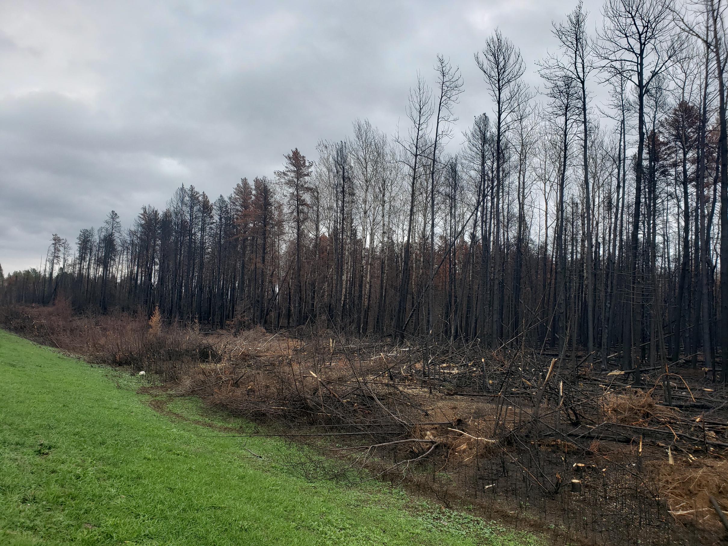

May the rivers be crooked and winding, and your portages lonesome, leading to the most amazing view.
10/09/2021 07:36PM
Nice pics LindenTree. How did highway 1 look?
I think that first pic is part of the burn out they did. I do believe some of that also burned about 5 years ago during the Sand Lake fire. Quite a mess isn't it?
I heard from my daughter who was just up there that they have been salvage logging along highway 2. A good idea I think as there is nothing scenic about fire killed trees and they'd be falling into the right of way for years.
How's Divide Lake? At the campground or the dispersed site?
10/10/2021 07:52AM
marsonite: "Nice pics LindenTree. How did highway 1 look?
I think that first pic is part of the burn out they did. I do believe some of that also burned about 5 years ago during the Sand Lake fire. Quite a mess isn't it?
I heard from my daughter who was just up there that they have been salvage logging along highway 2. A good idea I think as there is nothing scenic about fire killed trees and they'd be falling into the right of way for years.
How's Divide Lake? At the campground or the dispersed site? "
There were log decks along hwy 2 but I think they were from fuel breaks done by the fire team. It usually takes quite a while to set up a salvage logging operation because the Forest will have to follow most of the same permitting process as a normal sale. It is possible there could be salvage logging going on private or DNR land now.
Hwy 1 looked good and it will heal up real nicely, it looked like most of the fire along 1 was from a burnout/backfire. That fire didn't appear to carry into the woods more than 2 to 300 feet at best. I only drove hwy 1 from hwy 2 toward the Knotted Pine, not toward Ely.
I'm at the campground on Divide Lake, I've stayed at the dispersed site a couple times, but not in twenty years. I tried 18 Lake CG but the 3 sites were full, and Little Isabella River CG is closed. Firefighters were staying there during the fire and it has a bear problem now.
May the rivers be crooked and winding, and your portages lonesome, leading to the most amazing view.

Subscribe to Thread
Become a member of the bwca.com community to subscribe to thread and get email updates when new posts are added. Sign up Here
Community Links
 Search BWCA.com
 Donate
 Featured Sponsor
