



|
 Boundary Waters Quetico ForumTrip Planning ForumEnd of permit season - October...is the whole place open? |
 Forum Sponsor

Author
Text


09/23/2026 07:31AM
Who knows?
After the Pagami Creek Fire we pulled up to the Island River entry point in mid October. There was a forest service employee sitting in the parking lot. I asked him if it was ok to head down the river, and he said, "have at it." So I did. We also hiked the Pow Wow Trail over the Thanksgiving weekend that same year. I don't think it was officially closed, but the forest service was strongly discouraging people from walking the trail do to safety concerns.
After the Pagami Creek Fire we pulled up to the Island River entry point in mid October. There was a forest service employee sitting in the parking lot. I asked him if it was ok to head down the river, and he said, "have at it." So I did. We also hiked the Pow Wow Trail over the Thanksgiving weekend that same year. I don't think it was officially closed, but the forest service was strongly discouraging people from walking the trail do to safety concerns.
09/29/2026 09:00AM
The Post-October 1 Status
• The Closure Order Deadline: The active emergency closure order runs through October 1, 2026. However, Forest Service officials have explicitly noted that heavily impacted individual campsites, portages, and structural trails will stay closed for the remainder of the year to allow crews to clear hazard trees and repair damaged infrastructure.
• Self-Permitting Is Still Restricted: Even though you shift to free self-issued permits starting October 1, those permits do not override active emergency safety closures. Entering a closed zone carries steep federal misdemeanor penalties.
• Long-Term Closures: Heavily burned zones and specific western/central access areas that were shut down for the season (such as the areas around entry points #14 Little Indian Sioux North, #16 Moose/Portage River, and #19 Stuart River) will remain restricted until safety checks are completed ahead of next summer (2027).
09/29/2026 09:23AM
Some more info to pass along. Looks like we wont know for sure unless the forest service posts an official notice.
• Official Rescission or Extension: The U.S. Forest Service will evaluate the safety of these specific routes right up to the deadline. If ground crews determine that a site is still too dangerous due to unstable "hazard trees" or severely burned soil, they will issue a new, extended closure order that runs past October 1st.
• Safety Clearance over Calendar Dates: Because the BWCA quota permit season officially transitions into the non-quota season after September, visitors can technically enter without reservations. However, entering an area actively designated as closed due to resource damage remains illegal and highly unsafe, regardless of the date on the calendar.
The closure will officially lift only when the Forest Service formally posts a rescission notice for Order #09-09-06-26-07 on the Superior National Forest Alerts Page.

10/01/2026 09:18AM
I received this the other day.
Superior National ForestForest Service News Release
Joy VanDrie–Public Affairs Staff Officer
joy.vandrie@usda.gov
Superior National Forest website
Post BWCAW Wildfire Closure Updates
New order reopens more BWCAW entry points and areas on the Gunflint, Kawishiwi & LaCroix Ranger Districts
(Duluth, MN, September 30, 2026)—The Superior National Forest’s new forest closure order (09-09-00-26-11) is in effect with several areas reopening, and some closures through Spring 2027 for the Boundary Waters Canoe Area Wilderness (BWCAW) and surrounding National Forest System lands. Details available on the Superior National Forest’s Alert website.
Re-Opening–The following areas are reopening for day and overnight use:
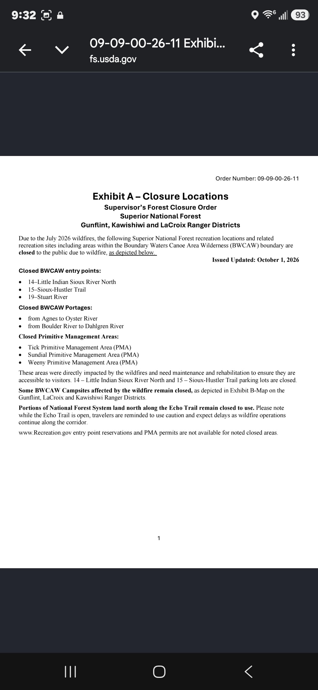
Reopened BWCAW entry points 11–Blandin Trail, 16–Moose/Portage River North, 20–Angleworm Lake, and 21–Angleworm Trail. For the Angleworm Trail entry points, no travel north of Home–Gull Portage. North Hegman and Angleworm portages are also opened.
There are no fire affected sites on Ramshead, Nina Moose and Agnes Lakes.Continued work by forest staff and volunteers has allowed for access into these reopened areas. Visitors should remain diligent about entering fire-impacted areas and watch for wildfire hazards like fire-weakened hazard trees and burnt stump holes.
Additionally, some campsites and portages in newly reopened areas remained closed due to direct wildfire impacts. Plan extra time to find a campsite if traveling through these areas with campsite and portage closures.
Closed through Spring 2027 - The following BWCAW Entry Points and portages will be closed through Spring 2027:Closed entry points 14–Little Indian Sioux River North, 15–Sioux-Hustler Trail, 19–Stuart River. These areas were directly impacted by the wildfires and need maintenance and rehabilitation to ensure they are accessible to visitors.
Related parking lots are closed.Please note portages from Agnes to Oyster River and from Boulder River to Dahlgren River are closed.Portions of National Forest System land north along the Echo Trail remain closed to use.
Please note while the Echo Trail is open, travelers are reminded to use caution and expect delays as wildfire operations continue along the corridor. Some BWCAW Campsites affected by the wildfire remain closed, as depicted in Exhibit B-Map. Additional campsites have been opened around South Arm Knife Lake and Lake Agnes areas.
"In wilderness is the salvation of mankind." Thoreau.
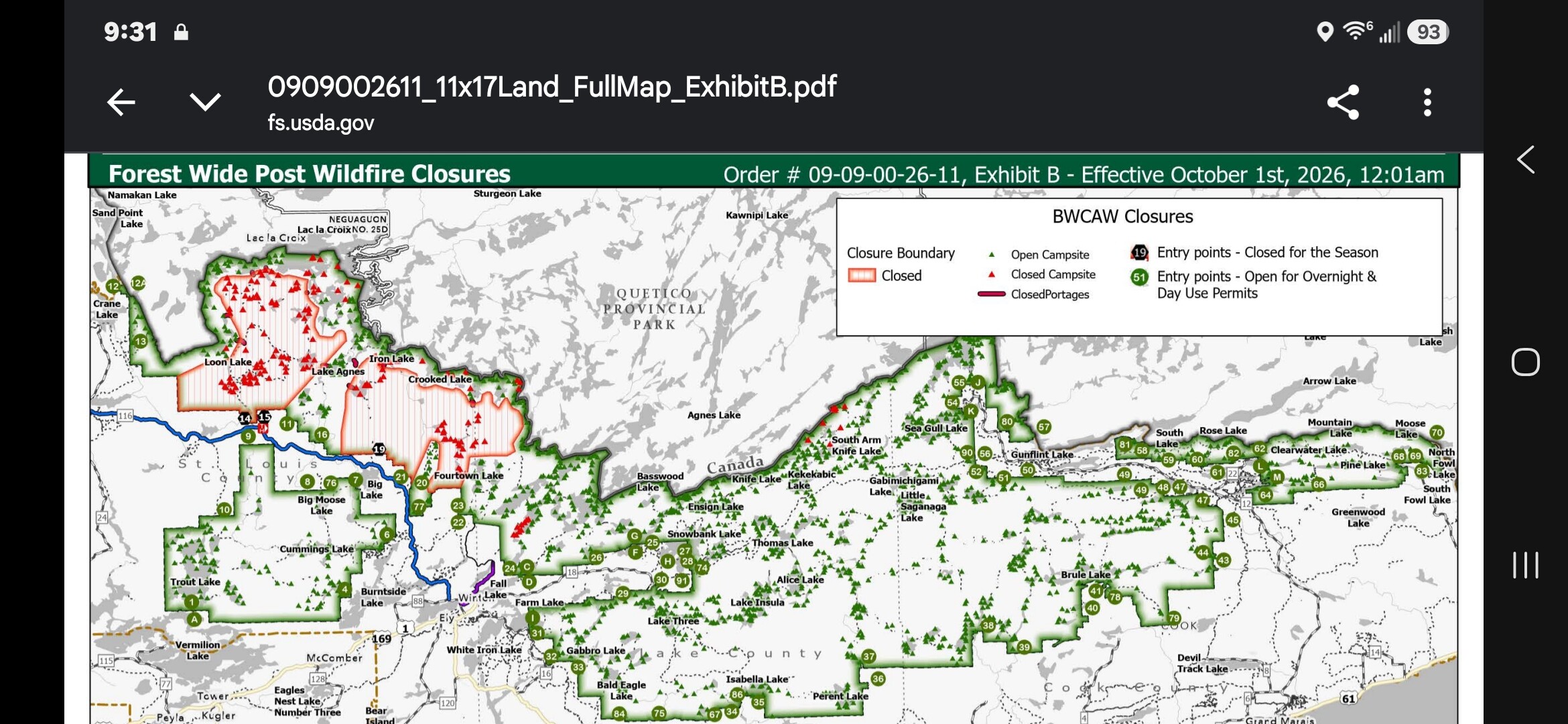
10/01/2026 12:06PM
papalambeau: "airmorse: "
Looking at the Exhibit B Map that Airmorse included it looks like the campsites on Loon Lake were hit hard. Is this correct? "
I had some questions about the Oyster side as well. Looking at other fire maps it looks like Oyster and Rocky (and most of Green/Hustler) were not burned although I'm not sure how accurate that is. I suppose it could be an access/resources/safety assessment issue as well, but I expected at least Oyster to reopen.
10/01/2026 12:39PM
papalambeau: "airmorse: ""
Looking at the Exhibit B Map that Airmorse included it looks like the campsites on Loon Lake were hit hard. Is this correct? "
It looks like the south and east shorelines of loon were hit, but most campsites are still open. You just have to enter from Crane Lake as other entry points are closed.
10/01/2026 11:08PM
Just finished doing the border route. It was very clear why the campsites listed on a previous map are closed...very toasted. There was a barrier across the Little Indian Soiux North EP parking area...didn't notice others. Personally I would not mess with the interior area below Lac La Croix. Based on what we saw as we paddle LLC, it could be hard to predict exactly where it would be safe or not safe to go before you got there. But it was very interesting to paddle past a lot of areas on LLC and Crooked. Stay safe everyone.

Subscribe to Thread
Become a member of the bwca.com community to subscribe to thread and get email updates when new posts are added. Sign up Here
Community Links
 Search BWCA.com


 Donate
Featured Sponsor
