



|
 Boundary Waters Quetico ForumListening Point - General Discussion Solving a Historic Mystery |
 Forum Sponsor

Author
Text


09/29/2026 07:03PM
A lady reached out via our info email at work to ask some questions about her grandpa, a man by the name of Isaac Haycraft, who visited the Ely area in 1907 and 1908 to stake a land claim with a large group of other people. She's asked for help figuring out some of the places. I was able to figure out some (it's tricky with how much has changed with roads being added and other features slipping away.) I know they started their venture on Long Lake (now known as Shagawa) and reached Lac La Croix - but the route in between in a mystery. I would love to figure out some specific spots and - if I can track down a platt map - figure out which piece of land her grandpa owned. If you are a student of history and love the BW, maybe you can help me crack the mystery!
Places I am looking for:
1) They travelled from Long Lake to Burntside via a "short portage" which makes me wonder if they actually went through Little Long. They stayed at an old logging camp on night one on the north shore of Burntside. Any ideas where that might have been?
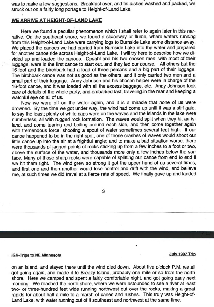
2) Height of Land Lake - The next day, they took a long portage into Height of Land Lake. At first, I thought this must be Tamarack or Mud. The old canoe route to Vermilion ran that way and there's a watershed divide between the two lakes, but the following description shakes up that theory. Any thoughts: "Breakfast over, and tin dishes washed and packed, we struck out on a fairly long portage to Height-of-Land-Lake. Here we found a peculiar phenomenon which I shall refer to again later in the narative. On the southeast shore, we found a sluceway or flume where waters running from this Height-of-Land Lake were carrying logs to Burnsides Lake some distance away." Other information they give us include reaching a place called Breezy Island - probably one mile from the North Shore. On the north shore, they found a river at least two or three hundred feet wide rushing northwest over the rocks "making a great rapids for about half a mile to a marsh of canes and rushes." And, most astoundingly, "this truly was Height-of-Land Lake, with water running out if it southeast and northwest at the same time." Any ideas? I can't think of anything that comes close to fitting the description. The inlets to Burntside are the Tamarack River, Slim Creek, Crab Creek, the Dead River, and some minor ones. None lead to a rapid set of that caliber. If anyone knows where a logging flume might be? I could contort my mind and say Vermilion, but it doesn't have two outlets.
3) Waterfall - sometime after Height of Land Lake, they discovered a stream no more than ten or twelve feet wide that took an abrupt drop of 60 feet.
4) Comfort Lake - They reached a marshy territory where the group split - some went to Lac La Croix while the others went dirctly west from the marsh to a lake a few miles across which they named Lake Comfort. The north shore had an "ideal smooth ledge of rock about 50x100 feet, some two feet above the lake surface, with a nice gentle slope to the water's edge." Near the campsite was an enormous spruce tree growing on a ledge of rock with a natural spring that flowd in a solid thin sheet into a semi circle about 150 feet across about 1/2" deep. It flowed about 200 feet down to the lake that hit the lake with enough force to make a boiling appearance.
I'm stumped on a few of these. I feel like I know the area fairly well, but enough has changed and, without knowing how long they were out, it's pretty tough to figure out. I don't know how they got from Burntside to Lac La Croix. My thought is they must have gone out to the Rainy River and come back at it rather than taking the traditional options of the Little Indian Sioux / Moose River / Portage River as nothing in the description of Height of Land Lake one portage from Burntside makes much sense to me. Anyone else have insight?
"Once you have heard the music of the Boundary Waters, you will yearn for it until you can yearn no more." - Miron Heinselman

09/30/2026 07:59AM
Could Height of Land lake be referring to Bass Lake? There used to be a sluiceway there. After the sluice was abandoned it eventually caused the washout of a glacial gravel deposit which made Bass lake lose 55 feet of water. I know I have a picture of the explanation sign that's at the trailhead but I can't for the life of me fine it right now. If you haven't hiked the trail there, I highly recommend it!
https://biglakelodge.com/wp/ely-mn-area-hiking-trails/
https://biglakelodge.com/wp/ely-mn-area-hiking-trails/
09/30/2026 08:51AM
Good thought Pretty Paddle. That was one of my three theories also (and I think it's the best theory right now.) All theories have drawbacks and I feel like something has to be wrong in the writeup for any of them to be right (unless I'm missing something.)
For Bass Lake: Pros - It would be a longish portage from Burntside to Bass. There was a sluiceway there and there would have been an island about a mile off the northern shore when that was a much larger lake before the collapse. Con: Even before the collapse, it doesn't seem a large enough lake to meet the description. Also, the sluiceway is on the Northeastern end of the lake. The description makes it seem like they encountered the sluiceway pretty quickly on the southeastern shore flowing towards Burntside. Now, I could write this off as him mis-writing his lake and meaning to say Basswood. But then, I don't know what he would have meant when they "reached the North shore to find a rapids two to three hundred feet wide." No such feature exists there. Maybe before the collapse there would have been something - but that Sluiceway should have already been there. I was wondering if, before the collapse, if the creek flowing from Little Long would have been flowing the other way? If the lake were 80 feet higher, then that creek could have very well been flowing the other direction. Bass feels like my best option right now.
I feel more strongly about this being the right solution though as I had a breakthrough this morning. I found their campsite via land patent records. The final campsite with the spring was on Ramshead. Her grandpa's land was to the east. Now it's just about connecting the dots!
"Once you have heard the music of the Boundary Waters, you will yearn for it until you can yearn no more." - Miron Heinselman
09/30/2026 09:45AM
I think prettypaddle lays down a pretty good case for Bass Lake.
The large river near Burntside..... All I can think of would be the Burntside River at high water levels. The initial drop out of Burntside is enough to great a churn when its running high. But the direction is wrong
If Height of Land is Bass they could have gone down the Range River toward Jackfish Bay, There is a decent drop on the Range though not 60'. If they skipped the last section of the Range and split up on Horse with one group taking the Horse River to the border and then Lac La Croix, the other group could have gone immediately West- Fourtown's rock matching that of "Comfort Lake"
All speculation.
Nobody exists on purpose, nobody belongs anywhere, everybody’s going to die.

10/02/2026 05:54PM
As someone who knows that area well and worked out of Little Long and still stay with friends there, this is a puzzle. I would have said Bass also, but very little fits. There is a creek that flows out of Bass to Little Long, but not Burnside. The Echo Trail crosses it. There definitely is no height of land there, although the trail to the falls goes up. In 1959 I even did a survival solo near the falls. Without reading the entire narrative it is hard to speculate. Old narratives can be really tricky especially when they decide to make up their own names for lakes. We all know lake names also change. I am inclined to say Burnside is wrong and refers to a lake we know by a different name. Basswood would be a possibility but in 1907 there was a lot of logging in that area. Even if Burnside is right, there are a lot of ways to get to La Croix from there, so without the complete narrative it is hard to say.

10/03/2026 09:18PM
My guess is that Height of Land is Crab lake. Logging operations of that era manipulated water levels quite a bit through construction of dams. Burntside lake levels were raised by maybe 10 feet or more around the turn of the century when the outlet to the Burntside river was dammed. Perhaps Crab was similarly dammed creating a rapids down to Korb creek? From crab to Cummings then Big Moose to the moose river and on to Ramshead seems the likely route, but again that's just a guess. I love a good mystery though!

Subscribe to Thread
Become a member of the bwca.com community to subscribe to thread and get email updates when new posts are added. Sign up Here
 Search BWCA.com


 Donate