|
 Boundary Waters Quetico ForumGroup Forum: GPS Map Overlay
|
Author
Text
")


08/25/2010 11:28AM
Are you using mapsource?
If so here is what I did, I downloaded this and put it into mapsource then when I have that on the screen I opened up the portage and campsite file I have on top of it.
Now, I have yet to figure out how to transfer this all to the GPS unit itself, mainly because I need to pick up a bigger Micro SD card. And mess around with it.
"Pack lightly, Tread lightly"
08/25/2010 01:21PM
quote Corsair: "Are you using mapsource?
If so here is what I did, I downloaded this and put it into mapsource then when I have that on the screen I opened up the portage and campsite file I have on top of it.
Now, I have yet to figure out how to transfer this all to the GPS unit itself, mainly because I need to pick up a bigger Micro SD card. And mess around with it. "
That is also what I have done. To get it onto the GPS, you just have to hit the export button. One thing to keep in mind, export both files at the same time. I believe this is how you have to do it to get both to show up at the same time on the GPS.
")

08/25/2010 01:36PM
Open a MN topo in Mapsource

then opened under waypoints
bwca-camp+port-wpt.gpx
and got

saved as LIS camps and portages

working on the portage trails, have not figured those out as far as combining into 1 map.
butthead
PS; just messin' around with Mapsource, on my Delorme stuff I have it!
Might need to borrow a buddies GPS 60 to try it out. The topo did transfer to my Nuvi 255w.
"never underestimate the power of stupid people in large groups" George Carlin
08/26/2010 08:58PM
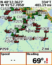
JD - one thing to think about is how many waypoints your GPSr can store. For example the Garmin eTrex Legend can store 1000 waypoints. The Oregon 450 can store 2000. You'll notice that the gpx file that you downloaded contains 3865 waypoints.
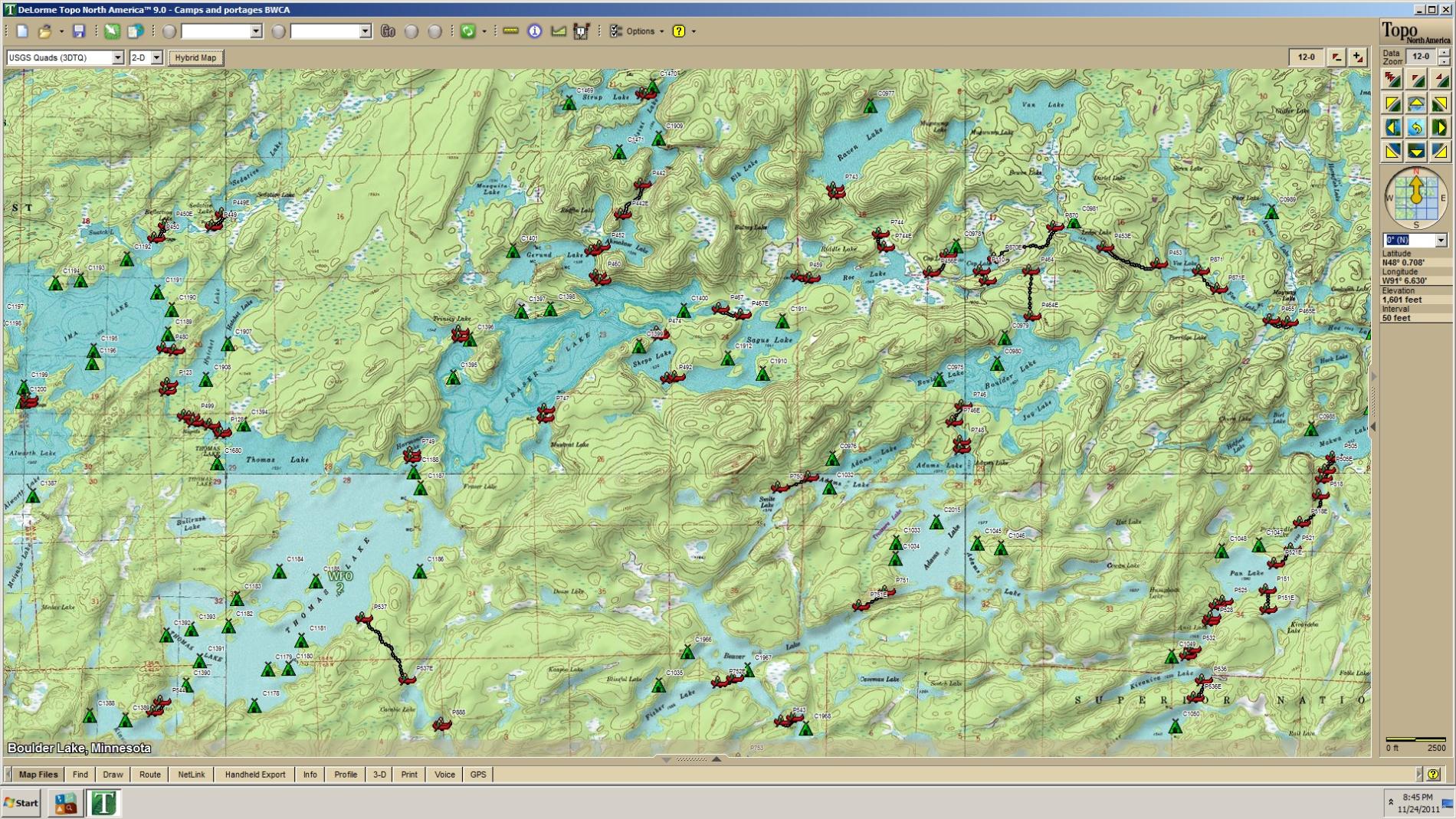
I created this overlay map for Garmin units. If you have a GPSr that can use maps, you should be able to send the Minnesota Topo map and the BWCA overlay. Then you would have all the campsites/portage points(with distances in meters and rods)/portage trails/misc. other points of interest.
One drawback to the Garmin Mapsource software is that you aren't able to view 2 maps at the same time. You have to use the drop down menu to select one map, then flip back to the another one.
"Stars are dancin’ on the water here tonight
It’s good for the soul, when there’s not a soul in sight"
- "I'm Alive" - Kenny Chesney
08/27/2010 08:49AM
PL,
Thanks for the advice! I've already learned about the file name limitation (see my other post). I typically only upload small portions to my Legend at a time, only one or two 'squares' from the Topo map. It seems to run much faster that way.
JD
Thanks for the advice! I've already learned about the file name limitation (see my other post). I typically only upload small portions to my Legend at a time, only one or two 'squares' from the Topo map. It seems to run much faster that way.
JD
06/20/2011 12:57PM
quote ChicagoMoose: "Butthead -
I just picked up a Delorme. Can you point me in the right direction to get portages and campsite overlays on it? I think you have them on yours.
Thanks!"
Portage and camp data
 Draw screen in Topo9, use the import tab then select the gpx files to overlay.
butthead
"never underestimate the power of stupid people in large groups" George Carlin
11/19/2011 09:05AM
quote butthead: "quote ChicagoMoose: "Butthead -
I just picked up a Delorme. Can you point me in the right direction to get portages and campsite overlays on it? I think you have them on yours.
Thanks!"
Portage and camp dataDraw screen in Topo9, use the import tab then select the gpx files to overlay.
butthead "
Butthead, do you know if there any easy way to edit so I could have a different color pins for the camps vs. portages while doing this for my PN40?
KevinL
11/20/2011 11:39AM
Butthead: I have a PN-30 and Topo8, I can import GPX files as you say above, but I have problems with the files available in the location you give. It seems there is alot of garbage (lacking formatting?) I'm thinking my browser ( Firefox) is displaying the XML data and not the GPX data as Topo expects it. Doesn't Topo just want the lat & long data minus all this extra formatting?
let science, not politics decide, ... but whose science?
11/23/2011 02:12PM
quote ZaraSp00k: "Butthead: I have a PN-30 and Topo8, I can import GPX files as you say above, but I have problems with the files available in the location you give. It seems there is alot of garbage (lacking formatting?) I'm thinking my browser ( Firefox) is displaying the XML data and not the GPX data as Topo expects it. Doesn't Topo just want the lat & long data minus all this extra formatting?
"
Zara, If you send me your e-mail (click the envelope in my profile) I'll send you the files.
Kevin, I think you can edit the colors just not sure, will try and get back to ya.
butthead
"never underestimate the power of stupid people in large groups" George Carlin
11/23/2011 06:24PM
Thanks butthead, I really appreciate that, I updated my profile for correct email & to show it to others, but for some am having problems trying to send you one, maybe you can send it to me now?
let science, not politics decide, ... but whose science?
11/23/2011 06:38PM
quote butthead: "quote ZaraSp00k: "Butthead: I have a PN-30 and Topo8, I can import GPX files as you say above, but I have problems with the files available in the location you give. It seems there is alot of garbage (lacking formatting?) I'm thinking my browser ( Firefox) is displaying the XML data and not the GPX data as Topo expects it. Doesn't Topo just want the lat & long data minus all this extra formatting?
"
Zara, If you send me your e-mail (click the envelope in my profile) I'll send you the files.
Kevin, I think you can edit the colors just not sure, will try and get back to ya.
butthead "
Thank you sir.
KevinL
11/24/2011 12:07PM
thanks Butthead, I was formerly entering these individually as needed ugh!
I was able to import the campsite and portage waypoints, which is the main thing I was looking for, but not the portage tracks, which is OK. Once I find the portage, if I get lost on a BWCA portage trail, probably should have stayed home :)
I was able to import the campsite and portage waypoints, which is the main thing I was looking for, but not the portage tracks, which is OK. Once I find the portage, if I get lost on a BWCA portage trail, probably should have stayed home :)
let science, not politics decide, ... but whose science?
04/19/2012 08:18PM
quote plquinn: "I created this overlay map for Garmin units. If you have a GPSr that can use maps, you should be able to send the Minnesota Topo map and the BWCA overlay. Then you would have all the campsites/portage points(with distances in meters and rods)/portage trails/misc. other points of interest."
plquinn... you around? I think I'm already pretty well set for BW map/waypoint/track needs, but I did finally get around to looking at your BWCA Campsites & Portages Map overlay. It involved a bit of a work-around to convert it to use on my iMac. I followed Boyd's helpful directions on the gpsfiledepot forum for converting from Windoze to Mac, but I'm not sure that I got a useful map. It was opaque and had a lot of stray, straight markings. I appreciate your efforts, but unless there is a different way to convert it and produce a better outcome, I guess I'll stick with what I already have.
"You can observe a lot just by watching." -- Yogi Berra

Subscribe to Thread
Become a member of the bwca.com community to subscribe to thread and get email updates when new posts are added. Sign up Here
Community Links
 Search BWCA.com
 Donate
 Featured Sponsor
