|

Author
Text
")

12/15/2010 10:53PM
So I am surprised that Rob has not posted this already, but Rob and I have chosen to go to Mugwump PMA. What do people know about mugwump PMA. Anyone been?
"I have fished through fishless days that I remember happily without regret." - Roderick Haig-Brown

01/11/2011 08:41PM
This one is on my "to-do" list. There are/is an old line of portages starting from Leg (bottom of Gabi) A 70r to Image, short hop to a no-name, another short hop to Horsefish and then an old long portage over to Pace. Not sure how to get from Pace to Amimi, but it's short. There is an old campsite on Amimi. That's my goal! From Amimi, there was an old portge (long) down to Vee, or you may be able to go south out a creek/swamp to Mayway. These old portages may be super hard to find....I have no idea. If you beat me there, please share.....
"What could happen?"
01/12/2011 08:29AM
We were actually not planning on going into the southeast section of Mugwump that you describe so I don't think that I will be able to give you any first hand knowledge of this area when we get back. We intended to go into marble and travois check out the northern section then try to get over to Van and check out the western section.
One question though, how do you know about old portages and camp sites? is there a resource somewhere or is it just on old maps that you have. If it is old maps do you know if there are any old camp sites on travois or old portages to get there. Old portages might not mean anything in this area after the blowdown though.
One question though, how do you know about old portages and camp sites? is there a resource somewhere or is it just on old maps that you have. If it is old maps do you know if there are any old camp sites on travois or old portages to get there. Old portages might not mean anything in this area after the blowdown though.
"I have fished through fishless days that I remember happily without regret." - Roderick Haig-Brown
01/12/2011 12:43PM
Some of the old sites and portages are in this book .
A friend also showed me an older edition of this book that had more sites and portages in it. They have been deleting them over the years. In either case, I found no other sites other than one on Amimi, Rapture and Raven and I found no portages into Travois. There are some creeks from Gabi/Image to Pouch, then to Marble, then to Travois. Chilly has been to Travois, but he loves it so much, I'm not sure he'll share with you how to get there. He told me that they bushwacked in off the Kek Trail. I'm not sure what it's like coming in from the east along the creeks. Good luck.
A friend also showed me an older edition of this book that had more sites and portages in it. They have been deleting them over the years. In either case, I found no other sites other than one on Amimi, Rapture and Raven and I found no portages into Travois. There are some creeks from Gabi/Image to Pouch, then to Marble, then to Travois. Chilly has been to Travois, but he loves it so much, I'm not sure he'll share with you how to get there. He told me that they bushwacked in off the Kek Trail. I'm not sure what it's like coming in from the east along the creeks. Good luck.
"What could happen?"
05/14/2011 11:04AM
cowdoc, if we have time, we're looking at doing that same Leg-Amimi route except the other direction, coming in from the SW, the end of this month. We'll see - we'll have been back to Raven and will have taken what sound like some fairly rugged portages coming over from Cap-Lege-Vee so we'll see if we're still up for it at that point.
I'm thinking the same thing you are, that it looks like it might be possible to paddle in and out of Amimi and avoid that "portage" over to Vee. The terrain in that area on the Mackenzie map makes it look like it could be a boggy, buggy adventure.
I'm wondering if we may get an assist with that with spring high water, and maybe up at the NE end at Image and Leg. Of course, it could just make everything boggy too, who knows. But at least there won't be as much for aquatic plants so we should be able to tell when we're getting stuck.
So...any thoughts on how long it could take to get through here? It looks like it's only about 3 miles but with 4, maybe 5 portages....
I'm thinking of spending a night on Raven, the next night on Amimi, and then heading out towards Gabi the next morning.
BTW, it looks like it should just be a short hop across from the southern tip of Gabi to Little Sag. Anyone ever done that? I've never been down to that end of Gabi.
05/14/2011 09:27PM
I've heard there is a portage along the creek from Mayway to Amimi. May want to check that out. Also, the portage from Pace to Horsefish may still be doable but harder to find going your direction. I wouldn't be suprised to eat up a good chunk of a day to go from Amimi to Gabi...high water may help. Dont know about Gabi to Lil sag....not that far up to go in thru Rattle though. Good luck!
"What could happen?"
05/15/2011 09:20PM
sinking, thanks for the other thread. It'll be interesting to compare notes on the northern and southern regions of the PMA. Blowdown could put a major damper on both. Don't know, this'll be my first time in that area.
Cowdoc, we'll definitely check out the route from Mayway to Amimi. Curious that there was an old portage from Vee into Amimi when on a map it looks so much easier to come up from Mayway. The moose and the old-timers generally know what they're doing so I wonder what we'll find.
Cowdoc, we'll definitely check out the route from Mayway to Amimi. Curious that there was an old portage from Vee into Amimi when on a map it looks so much easier to come up from Mayway. The moose and the old-timers generally know what they're doing so I wonder what we'll find.
05/15/2011 09:54PM
I have the portage marked as starting from the farthest east tip of Pace (Pace to Horsefish)
I believe the portage along the creek from Mayway is on the east side of the creek. Haven't seen them myself....just research and talking to people.
Horsefish to Noname/Image follows the creek out the northeast corner.
Hope it helps.
I believe the portage along the creek from Mayway is on the east side of the creek. Haven't seen them myself....just research and talking to people.
Horsefish to Noname/Image follows the creek out the northeast corner.
Hope it helps.
"What could happen?"
05/16/2011 07:29PM
thanks for the detailed info about the portages. I'd been relying on the old Fisher map and they don't seem that precise in pinpointing locations. And it doesn't show anything for Mayway to Amimi. Great to have some word of mouth from someone who sounds like he's been there.
05/22/2011 08:04PM
Just got back from our trip to Raven. We traveled east to Hoe from there and scouted out the entrance into Amimi. There is an old, barely decernable portage at the end of Mayway to the east side of the creek. It is a rough hike down through a valley and back up but then flattens out at the southern end of Amimi. Looks like a gorgeous lake! Good Luck!
05/22/2011 08:30PM
Great to get the info, thanks. Looks kinda dry, dryer than I thought it would in May. I hear not much rain but maybe the last couple of days have changed that. We're you lining back to Raven?
One week till we're back there but my mind has pretty much left already. The maps and the fresh food are the only things left to pack! Hope we see your moose.
Looks like you put your aluminum foil to its best possible use!
One week till we're back there but my mind has pretty much left already. The maps and the fresh food are the only things left to pack! Hope we see your moose.
Looks like you put your aluminum foil to its best possible use!
01/01/2012 06:25PM
Van was a target lake for us...we never got there. We were attempting to come in from Travois. We couldn't get a canoe into Travios so there was no reason to push on to Van. Even if we had...it appeared as though the blowthrough covered much of that area between Van & Travois.
It looks much easier coming into Van from the south (that was the way we had planned on leaving) but never got there to check it out.
It looks much easier coming into Van from the south (that was the way we had planned on leaving) but never got there to check it out.
I always wondered why somebody didn't do something about that. Then I realized I am somebody. Lily Tomlin
01/02/2012 03:15PM
A group from Chicago would fly into the lake way back in the day and fish it hard. I think Chicagoians were primarily perch fisherman though. Not sure where I read that so take it on face value.
"Now days these kids take out everything: radar, sonar, electric toothbrushs" Quint
01/16/2012 08:24AM
Thanks for the info Chilly. Seems crazy that people would fly in for perch, but who knows. I think I saw a post of yours that indicated you made it to sedative lake. Was that worth the effort? It seems there may be northerns in there? Last year my group did a day trip to a PMA lake west of Wednesday bay and it was the highlight of our trip!
01/16/2012 09:38PM
Sedative was a walk in the park, very easy to get to. We fished it hard for maybe 2-3 hours and didn't catch a darn thing. It was bog stained and looked mucky, maybe there just isn't any good ground to spawn but who knows. We did see overly large schools of minnows like we did in Travois, that might be another indicator of lack of game fish.
I think the Van advise came from Bill Rom's book. Van looks like an easy one to get to. Might day trip there in May.
I think the Van advise came from Bill Rom's book. Van looks like an easy one to get to. Might day trip there in May.
"Now days these kids take out everything: radar, sonar, electric toothbrushs" Quint
01/27/2012 12:52PM
quote Chilly: "
I think the Van advise came from Bill Rom's book. Van looks like an easy one to get to. Might day trip there in May."
I think Rom said they got skunked on Van, but they found where trees were cut back to allow a seaplane to dock so he figured there had to be fish.
T
01/27/2012 03:03PM
I rented a book from the library before last years trip, can't remember if it was Bill Rom's book or not, but it was pretty old. Anyway, the guy talked about traveling through a lake west of Wednesday bay and not catching much (or anything at all if i remember correctly). We ended up doing a day trip there and landed numerous large northerns. It was the best fishing we had all trip. Makes me wonder what is in Van, just not sure if we will go through the work to get there or not...
02/23/2012 08:22PM
When we were researching Van for our trip, I thought I ran across something that said that Van had lakers in it. It I can find that again, I will post it here. I am pretty sure that Raven also has a population of lakers. Raven does show up on the Voyageur map 6 as having a less than average # of lakers but average size.
"I have fished through fishless days that I remember happily without regret." - Roderick Haig-Brown
02/25/2012 03:39PM
so i just went to the library and took a look at William Rom's book. He said that people used to fly into the lake for its great fishing, but when he was there, they couldn't catch a thing. I have to imagine if it was fished out that long ago, maybe the fish populations have come back? Anyone have any first hand knowledge?
")

08/17/2015 01:08PM
quote cowdoc: "I've heard there is a portage along the creek from Mayway to Amimi. May want to check that out. Also, the portage from Pace to Horsefish may still be doable but harder to find going your direction. I wouldn't be suprised to eat up a good chunk of a day to go from Amimi to Gabi...high water may help. Dont know about Gabi to Lil sag....not that far up to go in thru Rattle though. Good luck!"
Just back from a solo out of Brant Lake off the Gunflint. Went to Gabimichigami and then Leg, Image, Horsefish, Pace, Amimi, and out of the PMA at Mayway. Back by way of Little Sag, etc. Info provided by Cowdoc and others was accurate. Did have to do some walking along creeks (e.g., Leg to Image, Image to Horsefish) where water level did not allow paddling, but often had decent moose path to follow. Portages still discernible (some marked with cairns, also), though some pushing through overgrowth required. From footprints, at least one other party through this summer, quite possible more. Used an old campsite on Leg, but otherwise picked a new LNT site of other lakes (had a nice rock knoll site on Horsefish). Old site on Amimi had a big dead pine right over tent pad; didn't use it. Did route in "short hops" (i.e., at least 2 hours, often, to get from one lake to the next, double portaging): camped on Leg, then Horsefish, then Amimi. Did not camp on Image, but it is pretty and has campable spots. No serious fishing, so can't report on that. Saw no one for the 3 days in the PMA; one moose swimming across Image.
08/18/2015 09:37PM
quote rtallent: "quote cowdoc: "I've heard there is a portage along the creek from Mayway to Amimi. May want to check that out. Also, the portage from Pace to Horsefish may still be doable but harder to find going your direction. I wouldn't be suprised to eat up a good chunk of a day to go from Amimi to Gabi...high water may help. Dont know about Gabi to Lil sag....not that far up to go in thru Rattle though. Good luck!"
Just back from a solo out of Brant Lake off the Gunflint. Went to Gabimichigami and then Leg, Image, Horsefish, Pace, Amimi, and out of the PMA at Mayway. Back by way of Little Sag, etc. Info provided by Cowdoc and others was accurate. Did have to do some walking along creeks (e.g., Leg to Image, Image to Horsefish) where water level did not allow paddling, but often had decent moose path to follow. Portages still discernible (some marked with cairns, also), though some pushing through overgrowth required. From footprints, at least one other party through this summer, quite possible more. Used an old campsite on Leg, but otherwise picked a new LNT site of other lakes (had a nice rock knoll site on Horsefish). Old site on Amimi had a big dead pine right over tent pad; didn't use it. Did route in "short hops" (i.e., at least 2 hours, often, to get from one lake to the next, double portaging): camped on Leg, then Horsefish, then Amimi. Did not camp on Image, but it is pretty and has campable spots. No serious fishing, so can't report on that. Saw no one for the 3 days in the PMA; one moose swimming across Image."
How hard was it to find the Horsefish to Pace portage on the Horsefish side?.....and what did it look like on the Pace side?
"What could happen?"
08/19/2015 10:13AM
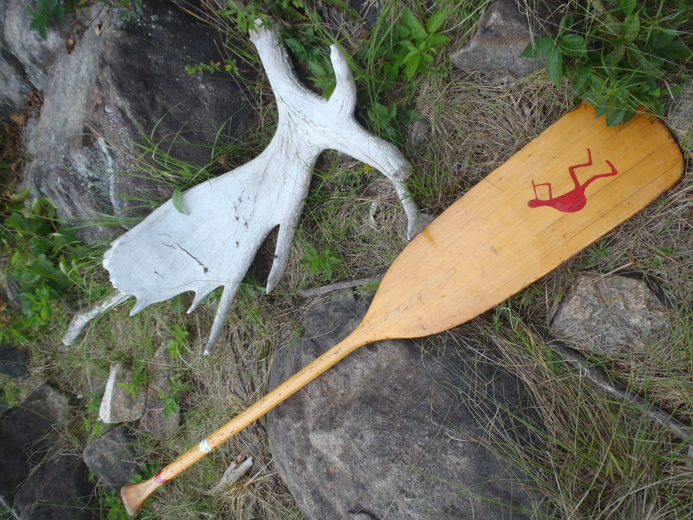
If you view Horsefish as a seahorse facing west (head north), the portage to Pace starts in the belly. I checked a couple likely starts, and it was obvious when I found trail going off into the woods west. The portage was also marked by a pair of moose antlers (photo of one). Maybe 150 rods (rough feel of it) and pushing through brush, but the foot-trail pretty clear to follow. At the Pace end, if I recall correctly, fairly open landing north of the little creek that connects to Amimi, and I think I saw a cairn, there. Just a lift over an ancient stabilized beaver dam at narrowest spot to get to Amimi. 
04/09/2016 06:13PM
Ray, Now for the rest of the story on the pair of moose antlers marking the portage on Horsefish L. I traveled through there a few years back solo. On the trail from Pace nearing Horsefish I found a moose antler. Arriving at Horsefish the trail in summer looked kind of obscure if I were to have to come back this way ( I was heading through Image and on to Gabi. and didn't know if it were doable, all I had for reference was 1952 map) So I went back to the antler and set it on the rock to mark the trail in case I had to return. No problems, I had a great trip. I decided to take my wife through the following May. On the trail from Pace to Horsefish, in almost the same spot where I picked up the antler was a moose antler. I told my wife someones been here since last Sept., I left this antler at the end of this trail. I picked it up and took it to Horsefish. You guessed, it there was the first antler still there. So I added the second. Were they from the same moose? Who knows. Never had much luck fishing in there, though I'm the worlds worst fisherman.

Subscribe to Thread
Become a member of the bwca.com community to subscribe to thread and get email updates when new posts are added. Sign up Here
 Search BWCA.com
 Donate