|
 Boundary Waters Quetico ForumQuetico ForumFinal decision...Zephira !!!!
|
 Forum Sponsor

Author
Text
")


02/05/2013 05:45PM
This lake has been on my bucket list for many years. I was set to go last year and plans fell through which happens way more then it should.
This year I was planning a trip to the Sutton River in northern Ontario. It is a great float trip for monster Brooke Trout that is a pretty easy 70 mile float trip with no portages. As I was making all the plans for this trip, equipment, maps, flights, etc., I thought this would be the canoe trip of a lifetime, but something in the back of my mind kept saying no, you need to go to Zephira.
I have been all over North America chasing big fish, and been pretty successful at it. So I asked myself, do I want to go to the Sutton and catch 3 to 6 pound Brookies all day, (which would be great) or going to Zephira and catching 4 foot northerns all day, or 25 inch walleye all day, or 21 inch smallmouth all day, or maybe 30 inch lakers all day, or maybe nothing all day.
My choice is going to be Zephira. Something is telling me this is were I have to go.
Reply
Reply with Quote
Print
Top
Bottom
Previous
Next
02/05/2013 11:01PM
You know, I think it's a good decision. The sutton can wait. Going to Zephira is going to be a really fun commitment for you. I hope you take pics and write up a trip report for us too.
"Life is not about finding yourself. Life is about creating yourself." --- George Bernard Shaw
02/06/2013 09:03AM
Haha, funny you posted this... just this past Sunday, my buddy and I were looking at Zephira, and decided we MUST GO. But it won't be this year for us.
We poured over the maps, and basically, there are two ways you could go about trying to get there...
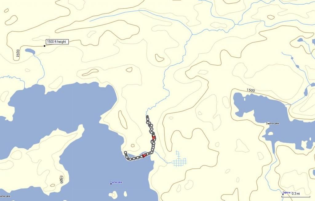
1. Cache Lake route... first, you have to get to Cache Lake, which is a rough trip to begin with. Once there, there is a bay along the eastern shore, which has a creek flowing into it from the NNE. The idea would be to try to get as far up that creek as possible... if it is somewhat navigable, you can even get as far north as just slightly north of Zephira, and if you look on satellite images, you will see there is an old logging road cut trending roughly 280-100. You can then follow it east, and it seems to peter out at a bog just NW if the northern tip of Zephira. Then crash in from there. If the creek is not navigable, or at least draggable, that far north, then get as far north as you can, and crash it east to Zephira. The bay of that creek on Cache looks like a nice wide opening, at least to get you north enough to avoid what appears to be a giant bog between Cache and Zephira.
2. Zephira Creek, from Tilly Creek. There is a logging road that runs near Tilly Creek, and seems to have little drives going west from it, paralleling Zephira Creek, that peter out just before the park boundary. They have little cuts that seem to go, in at least one case, right to the creek. That creek takes you to Zephira. This possibility rests entirely on how much water Zephira Creek has in it. If it is somewhat navigable, then this is definitely the preferred route. If not, then go with Cache Lake. Looking at the satellite, it does appear that Zephira Creek has some good water in it. As a comparison, I've been on the upper Cache River (the one that flows into the north end of Cache Lake), which was frustratingly ALMOST navigable in mid-summer. And it looks narrower than Zephira on the satellite.
I am jealous of your trip, as I know I won't be able to to this one for a few years. So please keep us informed!!!
We poured over the maps, and basically, there are two ways you could go about trying to get there...
1. Cache Lake route... first, you have to get to Cache Lake, which is a rough trip to begin with. Once there, there is a bay along the eastern shore, which has a creek flowing into it from the NNE. The idea would be to try to get as far up that creek as possible... if it is somewhat navigable, you can even get as far north as just slightly north of Zephira, and if you look on satellite images, you will see there is an old logging road cut trending roughly 280-100. You can then follow it east, and it seems to peter out at a bog just NW if the northern tip of Zephira. Then crash in from there. If the creek is not navigable, or at least draggable, that far north, then get as far north as you can, and crash it east to Zephira. The bay of that creek on Cache looks like a nice wide opening, at least to get you north enough to avoid what appears to be a giant bog between Cache and Zephira.
2. Zephira Creek, from Tilly Creek. There is a logging road that runs near Tilly Creek, and seems to have little drives going west from it, paralleling Zephira Creek, that peter out just before the park boundary. They have little cuts that seem to go, in at least one case, right to the creek. That creek takes you to Zephira. This possibility rests entirely on how much water Zephira Creek has in it. If it is somewhat navigable, then this is definitely the preferred route. If not, then go with Cache Lake. Looking at the satellite, it does appear that Zephira Creek has some good water in it. As a comparison, I've been on the upper Cache River (the one that flows into the north end of Cache Lake), which was frustratingly ALMOST navigable in mid-summer. And it looks narrower than Zephira on the satellite.
I am jealous of your trip, as I know I won't be able to to this one for a few years. So please keep us informed!!!
Nullum magnum ingenium sine mixtura dementiae fuit
02/06/2013 10:36AM
DWT: Regarding: " . . . there is a bay along the eastern shore, which has a creek flowing into it from the NNE. The idea would be to try to get as far up that creek as possible . . ." I once thought I could do something similar, and looked at maps and aerials beforehand, but when I got there, what I found in "reality" was FAR, FAR different from what maps/aerials showed. (West Bay of Quetico Lake up "Sly Creek") So, I guess my point is: expect the worse, maybe you'll get lucky, or maybe you'll get an African Queen "surprise." --Goose
Soloing is sweet, but a good partner is "priceless."
02/06/2013 11:58AM
quote OldGreyGoose: "DWT: Regarding: " . . . there is a bay along the eastern shore, which has a creek flowing into it from the NNE. The idea would be to try to get as far up that creek as possible . . ." I once thought I could do something similar, and looked at maps and aerials beforehand, but when I got there, what I found in "reality" was FAR, FAR different from what maps/aerials showed. (West Bay of Quetico Lake up "Sly Creek") So, I guess my point is: expect the worse, maybe you'll get lucky, or maybe you'll get an African Queen "surprise." --Goose"
That was pretty much my thinking as well, you never know either way. Which makes the Zephira Creek option riskier - unless you can get good confirmation about it.
What I'd probably do is plot a series of markers into the GPS, from that creek off Cache lake to the target lake, Zephira. One would be right at the beginning of the creek paddle, in case it is just entirely impassable. Then a couple more lines from points further up the creek, with the final one from that road cut (or what I am assuming is an old road cut). That gives you options.
Nullum magnum ingenium sine mixtura dementiae fuit
02/10/2013 08:26PM
Walllee, I read your report on your Badwater trip so I know you can do it. However...have you considered the time of year? Sweat, wet, skeeters, flys, brush at its thickest?
How about mid-late Sept? I know you can do it but don't you think you could give yourself an even break? I'm worried about you already.
How about mid-late Sept? I know you can do it but don't you think you could give yourself an even break? I'm worried about you already.
02/11/2013 08:13AM
Thanks for your concern. September would be the best time to go, but I do a B.W.C.A. trip with my wife every year at that time, she loves it so I will continue that tradition. I am going to be very careful with how I approach this task. I have scheduled 2 days to study the route, without gear. We will take only a day pack with water, a little food, and mark the route with marking tape (which we will take down upon our exit) I no it might take even more then 2 days to accomplish this task. We will take it slow, documenting the chosen route very well. My goal is to give others the safest, quickest, easiest route to get to this lake. I have two weeks to accomplish this and it will be done. I will have my G.P.S. to track our route and will be able to share with all who is thinking about a trip here. I will also seriously fish this lake , and will have detailed reports on species, depth, location,etc. We will base camp on Cach and only have a spike camp on Zephira. If my plan to bushwack in on Zephira's north end is not doable because of the bog like terrain, we will attack it from the southern end. Time will tell.

02/11/2013 12:20PM
Use Bing maps instead of Google. They have better resolution. When you bushwhack into Zephira, stay away from anything that looks like low land, it's probably muskeg and that stuff is usually impassible. Use lines of topography on the maps to stay out of steep inclines or declines. Those little things that look easy on a map are not the same when you're bushwhacking with a canoe.
If you've been through all of this stuff before then disregard my text. Not sure where you are with bushwhacking.
Good luck. I can only say that with the right amount of determination, patience, physical strength, and mental preparedness, you will see the waters of Zephira. The water's fine, jump in!!
Tom
02/11/2013 12:40PM
I disagree with September for best time to bushwhack. I've stirred up many a bee hive & hornet nest in September.
I'll take the blackflies & skeeters of late May, anytime.
I'll take the blackflies & skeeters of late May, anytime.
As a dog returneth to his vomit, so a fool returneth to his folly
02/11/2013 08:00PM
I was scanning over the maps and man does that lake look tantalizing. It has been a while since I have done some major bushwacking. I appreciate the call of your inner wild and I can't wait to here the trip report. I bet you the fish will just start launching themselves into the canoe upon your arrival. It will be great to be in a place where very few humans go. I am heading into the northern part of the park with my son for his first trip and I will say hello to the north country before your arrival. Were heading in on June 5. Good luck to you boys and enjoy the journey, even if Zephira is the destination.
06/30/2013 06:39PM
Looking at possible routes to Zephira lake. Heading up the creek that runs north of Zephira I came to a place where the creek runs through lots of large rocks. I got out of the canoe on the rocks and walked on the rocks up to where the water splits and I got on the land in the middle. I followed this upstream a few yards and then crossed the water to the left (north). This put me on solid ground and good footing and away from the running water but still down in the valley. There was no down timber to make travel difficult but there were many small evergreen trees with interwoven branches that I was able to push through. The little creek looked like it would be paddleable for a long ways up stream. If you try to go around on the right I think you would want to get out of your canoe 30-40 FT before the rocks and follow that edge around the water. There is a large rock ridge I can’t see over to see what is there.
The East shore of Cache shows the scars from the storm 2 years ago. Hopefully when you get away from the lake the storm damage will not be so bad.
The question of the day is Freedom or Socialism?? MagicPaddler
07/30/2013 10:45AM
quote MagicPaddler: "We are about as anxious to hear about your trip as you are to go."
MagicPaddler, the intel master. Someone making this bushwack is the biggest tease of the Q. Post your trip report in the Q Aficionados to maintain top security clearance ;)
"...not all those who wander are lost..." JRR Tolkien.
07/30/2013 12:19PM
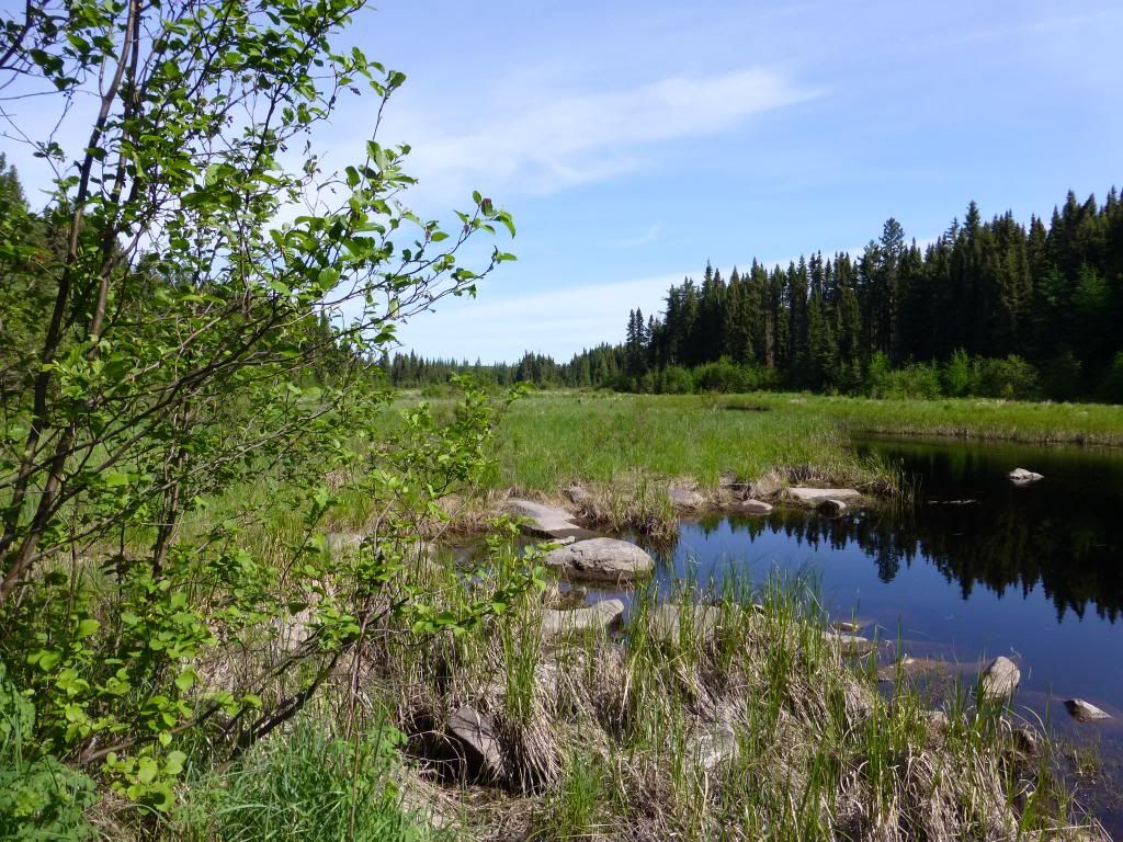
I had so many blisters on my feet from bushwhacking into Acheson Lake a few days earlier that I did not make an honest attempt at Zephira. The picture of the creek above is very near Cache lake. You can see the location clearly on Bing maps. Paste the following numbers into the bing map search.
48.55513 -91.0359
48.55513 -91.0359
The question of the day is Freedom or Socialism?? MagicPaddler
07/30/2013 04:59PM
Interesting. I can't make out the rocks on Satel. but it seems there's a chance the creek is navigable much further than your way point. October may leave it high and dry tho, who knows. I always thought it would best to try to make it via the creek another 1/4 mile or so around that right dogleg and see if that's an old two track that heads east then N/E. Perhaps less flesh eating scrub that way but maybe more marsh. Pick your poison ;)
Acheson Lake...???
Acheson Lake...???
"...not all those who wander are lost..." JRR Tolkien.
07/30/2013 06:52PM
quote Bushwacker: "Interesting. I can't make out the rocks on Satel. but it seems there's a chance the creek is navigable much further than your way point. October may leave it high and dry tho, who knows. I always thought it would best to try to make it via the creek another 1/4 mile or so around that right dogleg and see if that's an old two track that heads east then N/E. Perhaps less flesh eating scrub that way but maybe more marsh. Pick your poison ;)Bushwacker, I had the same thought. And as you stated the water level will play an important role in my plan of attack. I just hope my tripping partner can go. If not I may have to con one of you guys to go. I promised my wife I would not tackle it alone. I told her I could not think of a better place to die, but she did not think that was to funny. No sense of humor!!!
Acheson Lake...???
"
07/31/2013 06:44AM
I did not carry my canoe through to the spot where I took the picture of the creek. If I had I believe I could have paddled farther than what I could see form that spot. The water level was plenty high in June to paddle that creek. From what I saw I think you should at least be able to paddle to the spot Bushwhacker suggested.
I did not like doing it alone either.
Acheson is just south of Buckingham.
48.524 -91.272
I did not like doing it alone either.
Acheson is just south of Buckingham.
48.524 -91.272
The question of the day is Freedom or Socialism?? MagicPaddler
07/31/2013 10:40AM
I think I'd do it alone under the following conditions. Rent a satelite phone and a Spot beacon. Keep those in a water proof pouch with the gps in a fanny pack and never take it off till you're back at the ep. I don't think I'd do a solo wherever I went without the above tho.
MP~Anxiously awaiting a trip report about Acheson:)
MP~Anxiously awaiting a trip report about Acheson:)
"...not all those who wander are lost..." JRR Tolkien.
08/04/2013 12:24PM
quote walllee: "quote DancesWithTrees: "So... did the trip happen? You had said early-mid July, so, just checking in on you! Psyched to hear about it.Early october"
"
Be careful around bull moose, at that time.
As a dog returneth to his vomit, so a fool returneth to his folly
08/05/2013 04:51PM
quote Stumpy: "Yes Indeed!! My buddy got attacked while fly fishing in the Colorado high country a few years back. He was lucky to survive. He was able to escape by getting into the fast current that took him away from the Moose.The current he was in could of killed him also.quote walllee: "quote DancesWithTrees: "So... did the trip happen? You had said early-mid July, so, just checking in on you! Psyched to hear about it.Early october"
"
Be careful around bull moose, at that time."
10/24/2013 05:16PM
Let's get a group together and tackle it!!Primitive man sounds like he would like to try it. I'm sure with some planning and some mtxe(mental toughness,extra effect) it would be a piece of cake. I just know there are some 30 pound northerns just waiting for us!!!
10/25/2013 01:25PM
Oh man, I've been salivating over the lake on the map for at least a decade. I'm one of the crazies who does that NE part of the park regularly, I've been on Cache a bunch of times. I love being in the wildest part of the park. A buddy of mine and I have talked about going for Zephira.
I would love to do this. Just not sure I can take the full week of time that would be necessary next year to do this (wife and I work full time, have two young kids). You'd need at least a day just to get to Cache, and that is a very long, tough day (Trousers-Cache is a bear). Might be two. And you have to give yourself a day to get from Cache to Zephira - might take you a couple hours if you get very lucky, but more likely takes you half a day or more. Then you have to scrape a camp out of the bush. 6 days in Quetico is the minimum I'd want to put aside to do it, into and out of French.
That all said... if you want to try to put a group together with a bunch of random internet strangers... I might be game!
Nullum magnum ingenium sine mixtura dementiae fuit
10/25/2013 04:08PM
I think 8 days is a more realistic number. 6 days might well leave you not being able to attempt the bushwhack if you were slowed somehow on the way to Cache. Once in Zephira I want to spend at least one day exploring and fishing, two days or more would be better or at least to have that option. I can't see putting in all the effort to get there and then not find out what Zephira has to offer.
Jon
Jon
10/25/2013 04:58PM
quote Primitiveman: "I think 8 days is a more realistic number. 6 days might well leave you not being able to attempt the bushwhack if you were slowed somehow on the way to Cache. Once in Zephira I want to spend at least one day exploring and fishing, two days or more would be better or at least to have that option. I can't see putting in all the effort to get there and then not find out what Zephira has to offer.
Jon"
That would be ideal. I was saying 6 days as the minimum. Better is to take 2 days to get to Cache, 2 days back from Cache, leaving 4 days of stay-and-play. One day into Zephira, one day on, one day back, with a day left over to play with or keep in your back pocket if a problem comes up.
Nullum magnum ingenium sine mixtura dementiae fuit
10/25/2013 08:24PM
What I would do for a plan would be to spend a night on Cache. Then 3 nights on Zephira . That would allow 2 days to explorer Zaphira. Then plan on spending another night on Cache. I might leave a cache on Cache with some of my gear and food to lighten my pack for the bushwhack.
The question of the day is Freedom or Socialism?? MagicPaddler
10/25/2013 09:26PM
quote MagicPaddler: "What I would do for a plan would be to spend a night on Cache. Then 3 nights on Zephira . That would allow 2 days to explorer Zaphira. Then plan on spending another night on Cache. I might leave a cache on Cache with some of my gear and food to lighten my pack for the bushwhack. "yes indeed.
10/25/2013 09:48PM
There's a logging road about a mile due west just outside the park. Any chance a local outfitter could transport the crew to there? Could be on the lake in a day.
It would be a shame to spend less than three days there.
It would be a shame to spend less than three days there.
"...not all those who wander are lost..." JRR Tolkien.
10/26/2013 08:16AM
I have bushwhacked from that road to McKenzie. We did not make it in one day. We camped in the woods with out water. I look back on it as a good experience but I would not want to do it again. An outfitter will not drop you off there without permission from the park and the logging company who owns the road.
The question of the day is Freedom or Socialism?? MagicPaddler
10/28/2013 03:09PM
quote MagicPaddler: "I have bushwhacked from that road to McKenzie. We did not make it in one day. We camped in the woods with out water. I look back on it as a good experience but I would not want to do it again. An outfitter will not drop you off there without permission from the park and the logging company who owns the road. "
Fyi, I meant the road east of Zephira, outside of the park, not west.
"...not all those who wander are lost..." JRR Tolkien.
10/28/2013 04:43PM
That is the road I am talking about. About 3 miles east of the east end of McKenzie.
Past this N48.48790 W90.97040 into Bing maps
BingMaps
That is where we spent the night.
Past this N48.48790 W90.97040 into Bing maps
BingMaps
That is where we spent the night.
The question of the day is Freedom or Socialism?? MagicPaddler

10/29/2013 06:32PM
I did not mean I had walked from the logging road to Zephira when I said I walked from the logging road to McKenzie. In your red circle there are 2 blunt points sticking out to the west edge. Our camp was about 5.8 miles south of those points. Although it is not the same location there are many similarities. Darrel published the story in the spring 09 BWJ.
I have looked at satellite images of the creek coming out of Zephira it does not look like it could be paddled. I think the easiest way in is up the creek form Cache. I would suspect the roads that can be seen on satellite images near the NW end of Zephira are not passable. Compare the images of the roads near Zephira and the ones 6 miles to the south and the one on the other side of Cache. The roads near Zephira look more like the roads 6 miles to the south and those roads are planted with tree so close together that a canoe will not fit. The road on the west side of Cache is passable.
I have looked at satellite images of the creek coming out of Zephira it does not look like it could be paddled. I think the easiest way in is up the creek form Cache. I would suspect the roads that can be seen on satellite images near the NW end of Zephira are not passable. Compare the images of the roads near Zephira and the ones 6 miles to the south and the one on the other side of Cache. The roads near Zephira look more like the roads 6 miles to the south and those roads are planted with tree so close together that a canoe will not fit. The road on the west side of Cache is passable.
The question of the day is Freedom or Socialism?? MagicPaddler
10/29/2013 06:49PM
quote walllee: "Let's get a group together and tackle it!!Primitive man sounds like he would like to try it. I'm sure with some planning and some mtxe(mental toughness,extra effect) it would be a piece of cake. I just know there are some 30 pound northerns just waiting for us!!!"
Man, that would be FANTASTIC.....I've thought about it too.
Later,
Geo
10/30/2013 09:57AM
quote MagicPaddler: "I did not mean I had walked from the logging road to Zephira when I said I walked from the logging road to McKenzie. In your red circle there are 2 blunt points sticking out to the west edge. Our camp was about 5.8 miles south of those points. Although it is not the same location there are many similarities. Darrel published the story in the spring 09 BWJ.
I have looked at satellite images of the creek coming out of Zephira it does not look like it could be paddled. I think the easiest way in is up the creek form Cache. I would suspect the roads that can be seen on satellite images near the NW end of Zephira are not passable. Compare the images of the roads near Zephira and the ones 6 miles to the south and the one on the other side of Cache. The roads near Zephira look more like the roads 6 miles to the south and those roads are planted with tree so close together that a canoe will not fit. The road on the west side of Cache is passable.
"
I agree that the creek from Cache is the best way to go. Get as far north on it as you can, then track east to the lake. Ideally, you make it as far north as that "road". I believe, looking at satelite images, that road looks about the same as the one that crosses the Cache-Lindsay/MacKenzie portage. That road is actually much wider and easier to traverse than the portage itself. So if they are of similar age and type, I'd bet it is very walkable. To me, the question is, can you even get that far north on the Cache creek? If it turns out the creek is not mostly navigable up to that point, it makes sense to just head east anyway. But if you can get close to that road bed, I'd say it would be worth the shot.
Nullum magnum ingenium sine mixtura dementiae fuit
10/30/2013 04:21PM
It would be nice if the road was walkable. I think the end of the spur that heads for Zaphira goes to within .35 miles of Zephira. The road between Cache and Lindsay has been maintained by trappers until this year. So do not expect a 50 year abandon road to look like a maintained road. On our bushwhack to McKenzie we crossed roads several times and did not recognize them as any thing but an area with thick brush to be avoided.
The question of the day is Freedom or Socialism?? MagicPaddler
10/30/2013 05:05PM
When researching all the routes last winter I concluded that entering the creek leading north was the best option. I talked to some DNR people in Atikokan and they said that would be the only feasible way into Zephira. They said the roads were pretty much non doable.
10/30/2013 05:05PM
When researching all the routes last winter I concluded that entering the creek leading north was the best option. I talked to some DNR people in Atikokan and they said that would be the only feasible way into Zephira. They said the roads were pretty much non doable.
01/13/2014 06:16PM
I am hoping some of you are still thinking about this for next year. I have Zephira on the brain this time of year. I will not be able to do a summer trip due to the wedding in August of one of my children. So it is the opener in the BWCA and then Zephira in Sept/Oct if I can get at least one other person to attempt it with me. Wallee's wife is prudent in thinking to attempt this as a solo trip would be unwise.
Jon
Jon
08/27/2014 01:45PM
I did some exploring that may be of use to someone headed for Zephira.
I started up the creek. As far as I went it was deep enough to float me but with some kind of pullover every 100 ft. The creek banks were 3 feet high and less than 4 ft apart making a double blade paddle troublesome. There was a wide spot in the creek where I turned around.
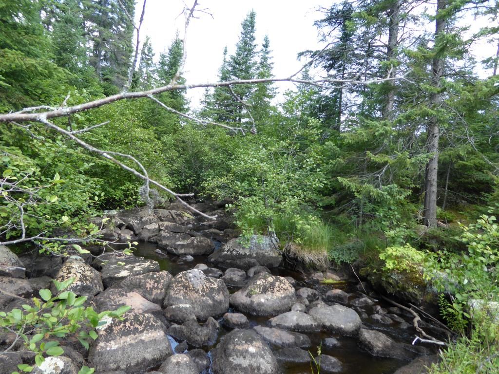
This is what you will see when you start up the creek. If you go to the tree that is on the right side of this picture and turn 90° away from the creek there is a path sort of follows a rock ledge. In about 100 Ft the path turns back parallel to the creek and goes to the little pond.
I doubt the creek can be paddled past the place where the logging road first meet the creek so I would have a GPS way point so I would know when I got there.
I started up the creek. As far as I went it was deep enough to float me but with some kind of pullover every 100 ft. The creek banks were 3 feet high and less than 4 ft apart making a double blade paddle troublesome. There was a wide spot in the creek where I turned around.
This is what you will see when you start up the creek. If you go to the tree that is on the right side of this picture and turn 90° away from the creek there is a path sort of follows a rock ledge. In about 100 Ft the path turns back parallel to the creek and goes to the little pond.
I doubt the creek can be paddled past the place where the logging road first meet the creek so I would have a GPS way point so I would know when I got there.
The question of the day is Freedom or Socialism?? MagicPaddler
08/28/2014 03:15PM
Wow, that's a pretty good distance in that you made it. Did it look pretty unpassable beyond where you turned around? And was it particularly high water at that time?
I figured when I looked at this trip, you mark a series of waypoints along the creek, from the mouth to the logging road. Then make trail tracks on the GPS from each of those points to the lake as best as the terrain and satelite mapping indicate can be done. That way you have a bunch of options depending on how far up that creek you get.
Thanks for posting!
Nullum magnum ingenium sine mixtura dementiae fuit
08/28/2014 03:40PM
The last point up the creek was made on August 16 @707AM this year. Water levels were about normal for this time of the year. I was in a smaller solo boat and the creek was passable upstream from where I turned around but there was a log or beaver dam every 100 ft. I recommend a small boat for this creek travel. I would plan on getting out of the creek around 48.560827 -91.033368 . My guess is creek travel will be quite slow by the time you get that far up the creek.
The question of the day is Freedom or Socialism?? MagicPaddler
08/28/2014 05:41PM
quote MagicPaddler: "The last point up the creek was made on August 16 @707AM this year. Water levels were about normal for this time of the year. I was in a smaller solo boat and the creek was passable upstream from where I turned around but there was a log or beaver dam every 100 ft. I recommend a small boat for this creek travel. I would plan on getting out of the creek around 48.560827 -91.033368 . My guess is creek travel will be quite slow by the time you get that far up the creek. "
Man. It looks like you were within 700' of the best bushwack take out.
"...not all those who wander are lost..." JRR Tolkien.
08/28/2014 06:05PM
quote Bushwacker: "quote MagicPaddler: "The last point up the creek was made on August 16 @707AM this year. Water levels were about normal for this time of the year. I was in a smaller solo boat and the creek was passable upstream from where I turned around but there was a log or beaver dam every 100 ft. I recommend a small boat for this creek travel. I would plan on getting out of the creek around 48.560827 -91.033368 . My guess is creek travel will be quite slow by the time you get that far up the creek. "
Man. It looks like you were within 700' of the best bushwack take out. "
I measure it as a little over 1400 ft to the take out. I just ran out of ambition and decided to do something else. I spent the rest of the day going down the Cache river.
How would you get to Cache Lake?
The question of the day is Freedom or Socialism?? MagicPaddler
09/03/2014 04:50PM
Another possibility is a rout I explored described in this trip report.
Report
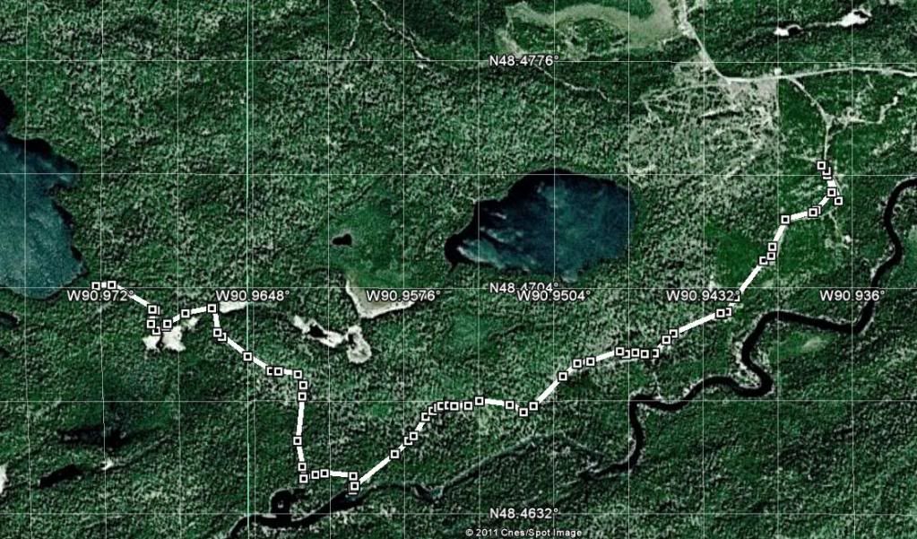
The lake on the left is Belaire. Depending on road conditions you could probably get dropped near where the east end of the GPS track ends.
I have talked to people who have been driven to Mack from Kakabeka Falls.
Report
The lake on the left is Belaire. Depending on road conditions you could probably get dropped near where the east end of the GPS track ends.
I have talked to people who have been driven to Mack from Kakabeka Falls.
The question of the day is Freedom or Socialism?? MagicPaddler
09/03/2014 05:08PM
Interesting. Is that the access point the Q administrators were thinking of putting a drive in access point in a couple years back? I read somewhere the logging companies had some of those roads signed/closed off. Maybe I'm thinking of the road that gives access to a creek which runs into Bemar. I'd love to spend a week camping outside the park in that area with an ATV exploring the roads and possible access points into the Q.
"...not all those who wander are lost..." JRR Tolkien.
09/03/2014 05:19PM
Here is the info I was thinking about. It does pertain to the Bemar/Elevation Lake area~
4-20-13
"Does anyone know if the bemar creek that flows into bemar lake has a motorized vehicle restriction? Ive been in this area before but I cant remember if it is or not. Thx.
No it does not. At one time you could access the creek where it is much wider off the Elevation Lake road. That beacame a restricted access point. They have since removed the bridge at the start of the Elevation Lake Road so it is no longer accessible. The only access is off the main road where the creek is more like a ditch. The creek ride is no cake walk, expect to drag the boat over a few beaver dams and dead falls. Early season when the water is higher is about the only time to go, later in the seson the lower section of the creek where it widens becomes weed choked. A light 12ft aluminum is the only way to go.
Last time I was there, the bridge was removed at Bemar Creek down the Elevation Lake Rd., not the start of Elevation Rd. I do agree about using small watercraft, if you can still access the river access point, you can get in with a 14 ft. in high water and have to deal with at least 3 beaver dams last time I was there. We used a 16 ft. Coleman Scanoe and just dragged it over them without having to unload anything except ourselves to get in and out of there.
My apologies, eyelander is correct the bridge was located a ways down Elevation Road. The last time we fished Bemar was June of 2011. At that time we tried to drive Elevation Road, we didn't make it 100 yards before having to stop and back our way out. It is almost completely grown in.
No MV restriction. If you are planning a trip in there do the portage into Ross Lake the fishing is off the charts!!! "
"...not all those who wander are lost..." JRR Tolkien.
09/03/2014 06:15PM
This road goes nowhere near Ross or Bemar. It comes in form the North. There were car tracks at the end of my GPS tracks. So I know someone got there in 2011 by car or truck.
I believe this was to be the new east entry.
I believe this was to be the new east entry.
The question of the day is Freedom or Socialism?? MagicPaddler
09/03/2014 08:28PM
As you probably know, the proposed eastern road access (via the Wawiag River) has been scrapped, and air access will be Powell or Ross Lakes. Ross is a beautiful lake and should have been included in the park, along with many of the lakes between Northern Light and Powell Lakes.
“Growth for the sake of growth is the ideology of the cancer cell.” -Edward Abbey
10/19/2014 01:07PM
Thought I would post a update. I was going to do this trip this early October. In mid Sept. I was on a trip and started to have some shoulder pain. To make a long story short It is a rotater cuff problem. Needless to say the trip did not take place. If it is not better by early winter it will be surgery time. It is still #1 on my bucket list, and will get done.....just not this year.
10/26/2014 11:27PM
quote walllee: "Thought I would post a update. I was going to do this trip this early October. In mid Sept. I was on a trip and started to have some shoulder pain. To make a long story short It is a rotater cuff problem. Needless to say the trip did not take place. If it is not better by early winter it will be surgery time. It is still #1 on my bucket list, and will get done.....just not this year."
Heal up & go for it.
Really, ..wishing you well, in this adventure.
As a dog returneth to his vomit, so a fool returneth to his folly
08/18/2016 03:02PM
What was the end result on Acheson? Was there ever a report on that?
If we aren't actively working to protect our planet, we are acquiescing to those who run their life as if their personal WANTS are the only things that matter. John
08/26/2016 09:14AM
Cant find my report on that trip. I got there sat on a rock and ate my lunch. The water was clear with several rocky points that may have provided a place to camp. I never got my canoe to the lake.
Two weeks ago I was on Cash Lake looking to do some Zephira exploring. I found that after doing the creek and then the 3 mile north portage I was too exhausted to start a 1 mile bushwhack. I am 70 now and I guess I need to remember that when planning a trip. Got home at 02:00 this morning.
Two weeks ago I was on Cash Lake looking to do some Zephira exploring. I found that after doing the creek and then the 3 mile north portage I was too exhausted to start a 1 mile bushwhack. I am 70 now and I guess I need to remember that when planning a trip. Got home at 02:00 this morning.
The question of the day is Freedom or Socialism?? MagicPaddler
Reply
Reply with Quote
Print
Top
Bottom
Previous
Next

Subscribe to Thread
Become a member of the bwca.com community to subscribe to thread and get email updates when new posts are added. Sign up Here
Community Links
 Search BWCA.com
 Donate
 Featured Sponsor
