|
 Boundary Waters Quetico ForumListening Point - General Discussion Another wall map question
|
 Forum Sponsor

Author
Text
")

11/18/2013 08:48PM
I know there have been a few threads recently about putting together a map that will cover a large bare spot on a wall. I've decided to piece together a set of maps to cover the BW/Q instead of trying to find a large one piece map. Has anyone ever tried using the McKenzie maps or just Fishers? Any reasons one over the other?
"Leave it as it is.....The ages have been at work on it and man can only mar it." Theodore Roosevelt

11/18/2013 11:17PM
here is a shot of an attempt i made many years ago at a full size park map.it starts at the far east end and i got as far as around Basswood river and up into the Q just short of Beaver House lake. i have more maps that have yet to be added on.

as you can see i was using McKenzie maps,i wanted lots of detail and a bigger size.because i was living in a cabin at the time i had no wall space so the idea was to roll the finished map on large plastic pipes.
spring loaded poles thru the pipes and some other fooling around would allow me to roll the map across the main room for viewing,rolling in in one direction or the other would give me a big if not full view of the park.
some problems were finding a clear tape,i put tape on both sides,that was strong but still let the map roll around the pipe without a lot of wrinkles and getting good match lines.you need lots of floor space to do this!!this is not the full map as i was not finished when i took this photo some years ago.
it's just a level trail thru the woods.
11/19/2013 09:15AM
That's quite the project you have started there! Any idea what the overall width would be when finished? My wall is about 14' wide by 8' tall, may need to use smaller scale Fishers to get it to fit. Instead of tape would a clear glue coating like Modge Podge work?
"Leave it as it is.....The ages have been at work on it and man can only mar it." Theodore Roosevelt
11/19/2013 10:28AM
Just a thought; get a piece of Tyvek to mount the maps to. Then when you move (it happens) you peal the Tyvek off the wall, roll it up, and take it with you. It also allows you to have a better way to mount the maps together without needing to tape the edges together with tape that will after time yellow. Spray glue works good if you follow the directions...
I'm just here to give my opinion...If you don't like it, ignore it.
11/19/2013 10:41AM
I was hoping to build a huge frame with some thin plywood as a backer. I wanted to go this route so I can use tacks and strings to record all the places I've been without filling the wall full of hundreds of holes. No need for me to roll the entire map up but I like the tyvek idea.
"Leave it as it is.....The ages have been at work on it and man can only mar it." Theodore Roosevelt
11/19/2013 11:07AM
quote DeanL: "I was hoping to build a huge frame with some thin plywood as a backer. I wanted to go this route so I can use tacks and strings to record all the places I've been without filling the wall full of hundreds of holes. No need for me to roll the entire map up but I like the tyvek idea."
Now you're talkin'...
I'm just here to give my opinion...If you don't like it, ignore it.
11/19/2013 11:17AM
We have our MacKenzie maps just tacked to the wall with push pins. It's easy enough later to just paint over the small holes. Anyway we don't have all of them on the wall. We have the parts we use the most - Ely area to the Gunflint. Next trip will be through Seagull to Little Sag.
It's nice to have the maps up year round so we can plan trips or just dream about our next trip
It's nice to have the maps up year round so we can plan trips or just dream about our next trip

11/19/2013 03:28PM
I put together the entire Fisher F-series some 25 years ago. Discovered that the maps don't quite match, though it was close enough that it didn't matter. Was a great way to get lost in planning routes and seeing patterns in the landscape.
Nobody exists on purpose, nobody belongs anywhere, everybody’s going to die.
11/21/2013 11:34AM
I did it with the National Geographic maps. When I calculated the space needed to do it with a set of the Voyageur maps (same scale as Fisher), it was just too big. McKenzie is a larger scale map and would take up even more room. I can't remember the exact dimensions, but it wouldn't be too hard to figure it out.

As you can see, I put four bulletin boards up (got them from Menards for $10 each). Then I ironed the maps (on low and with a cloth on top of the paper) to try to get some of the creases out. (It kind-of worked - at least made a little flatter and easier to put up.) Then I had to fold the maps because there is some overlap between them. I put the maps on the bulletin board using pins. We are filling in the rest of the space with a picture of each campsite we have visited. I am also putting a pin on each campsite we have been to.

As you can see, I put four bulletin boards up (got them from Menards for $10 each). Then I ironed the maps (on low and with a cloth on top of the paper) to try to get some of the creases out. (It kind-of worked - at least made a little flatter and easier to put up.) Then I had to fold the maps because there is some overlap between them. I put the maps on the bulletin board using pins. We are filling in the rest of the space with a picture of each campsite we have visited. I am also putting a pin on each campsite we have been to.
11/21/2013 01:14PM
Howard..this is a photo of the map i use in the Q that covers most of my trips and i take it along.i know my way around after all these years but a map comes in handy.
so anyway i posted this shot on a outdoor survival site as kind of a joke.i said with a map this huge i could use it as a cover for a emergency shelter..ha-ha-ha...well some guys posted ideas about which sort of clips and cords would work best!"use fish line around pebbles in the corners--no! plastic clips are the way to go"..so on..
so make a big map and keep it handy!!!
so anyway i posted this shot on a outdoor survival site as kind of a joke.i said with a map this huge i could use it as a cover for a emergency shelter..ha-ha-ha...well some guys posted ideas about which sort of clips and cords would work best!"use fish line around pebbles in the corners--no! plastic clips are the way to go"..so on..

so make a big map and keep it handy!!!
it's just a level trail thru the woods.
11/21/2013 05:05PM
I specifically went to a location on a new adjacent map each year then would tack the maps up on the wall after the trip. I was getting a nice big wall covering then we had a baby and had to change the room and I had to take down my mural.....:(
01/26/2015 07:46PM
I've been looking for a full BWCA wall map for awhile and finally found one. I just purchased the wall fabric version of this BWCA wall map last week and put it on the wall in my office today. What a great conversation piece - the first two guys who stopped by wanted to know where to get one for themselves.
Map is 51x29" and covers the whole BWCA - there is also a larger 77x44" version. It was made by a guy in Madison who spent several years putting it all together.

Map is 51x29" and covers the whole BWCA - there is also a larger 77x44" version. It was made by a guy in Madison who spent several years putting it all together.

01/26/2015 08:18PM
My brother did this with Fisher maps several years ago. He had to carefully cut them so as to remove overlap. He wanted to use McKenzie's but found his wall wasn't big enough to accommodate them. He covered them with thin plexiglass to protect them and so he could use a dry erase marker to plot routes. Before he leaves on a trip, he plots route for his wife.
Livin' the dream. Just another day in Paradise...
01/26/2015 08:19PM
bwbrian, that is a nice map you found. The only question is how big!
Actually, my real question is are the lakes outside the BW labeled well. I'm thinking about the White Iron chain near Ely. And maybe the Fenske loop that can be good camping but is not in the BW.
Actually, my real question is are the lakes outside the BW labeled well. I'm thinking about the White Iron chain near Ely. And maybe the Fenske loop that can be good camping but is not in the BW.


01/26/2015 08:44PM
quote andym: "bwbrian, that is a nice map you found. The only question is how big!
Actually, my real question is are the lakes outside the BW labeled well. I'm thinking about the White Iron chain near Ely. And maybe the Fenske loop that can be good camping but is not in the BW."
Sizes are 51x29" and 77x44"
Yes, the lakes outside the BWCA are well labeled. I was pretty impressed with the level of detail on the map when I got it last weekend.
01/27/2015 04:27AM
Thanks. My first question was actually just pondering how big I should get. I can do the big size in our cabin. We're remodeling our house right now and will need to find a spot for one of the sizes. Maybe on the wall over the head of our bed. That could work! Sweet dreams.
Extra ideas from my wife: shower curtain version. Decoration on kitchen cabinet doors.
Glad to know he did a great job on these. And thanks for finding them.
Extra ideas from my wife: shower curtain version. Decoration on kitchen cabinet doors.
Glad to know he did a great job on these. And thanks for finding them.
01/27/2015 07:49AM

My wife found a place in Minneapolis that laminated the whole Fisher map set in one fell swoop.
The maps she used are from the Fisher map book that contains smaller maps of the border country than the maps we take on trips. I love this wall map and use a dry erase marker to show past trips and plan new ones.
Tom
01/27/2015 08:34AM
Fisher sells an oversize map book of the entire parks. Here's the link: Fisher Map Book
Its not the detail of the actual navigation maps, but it might be a fairly easy and inexpensive way to get what you want. The scale is the same for each map, so they should line up.
I have to say, though, I like the looks of the giant wall map!
Edit: I don't mean to be redundant! Tumblehome had it first!
01/27/2015 09:34AM
quote SunCatcher: "When you take kiporby along and kanoes....they just bring the Map room with em.
SunCatcher

"
This is hilarious! No one gets lost on those trips, right?
Wherever there is a channel for water, there is a road for the canoe. -Thoreau
01/27/2015 09:34AM
quote bwbrian: "I've been looking for a full BWCA wall map for awhile and finally found one. I just purchased the wall fabric version of this BWCA wall map last week and put it on the wall in my office today. What a great conversation piece - the first two guys who stopped by wanted to know where to get one for themselves.
Map is 51x29" and covers the whole BWCA - there is also a larger 77x44" version. It was made by a guy in Madison who spent several years putting it all together.
Oh mannnnn, I am really tempted. Any idea why the large one doesn't come in wall fabric? What is the paper like I wonder? I really want the bigger one...
Wherever there is a channel for water, there is a road for the canoe. -Thoreau
01/27/2015 11:46AM
I've been sitting on this project for over a year and since it came back up I have some renewed interest. I really like the way the Fisher map book set and the Nat Geo maps you guys have put together look. I found the normal F series maps would be about 2' too wide for my wall and I would need to separate a section like Alaska is on a US map.
Tumblehome, is the place you had laminate your map open to doing more or was yours a special request deal?
Tumblehome, is the place you had laminate your map open to doing more or was yours a special request deal?
"Leave it as it is.....The ages have been at work on it and man can only mar it." Theodore Roosevelt
01/27/2015 11:57AM
I've always wanted to do something similar as well. I'm buying another Fisher book so maybe I can sacrifice the old one for the wall.
Otherwise, bwbrian does your map have all the details like portages, campsites, lake names, etc? It almost looks like it encompasses too much area to be able to have much detail.
Otherwise, bwbrian does your map have all the details like portages, campsites, lake names, etc? It almost looks like it encompasses too much area to be able to have much detail.
01/27/2015 01:37PM
Many years ago when I had a huge and empty wall in my residence I pieced together the entire Fisher F series. A word of caution- Fisher cheats a bit. It is not possible to get the maps to mesh perfectly. It looked good though- unfortunately all photos of my giant map wall pre date digital cameras and I have know idea where the photos are.
Nobody exists on purpose, nobody belongs anywhere, everybody’s going to die.
01/27/2015 01:56PM
quote DeanL:
Tumblehome, is the place you had laminate your map open to doing more or was yours a special request deal?"
I asked my wife and she can't remember who did it since it was about 15 years ago. If I were you, I'd start looking around. My map is a treasure.
01/27/2015 02:23PM
quote tumblehome: "
My wife found a place in Minneapolis that laminated the whole Fisher map set in one fell swoop.
The maps she used are from the Fisher map book that contains smaller maps of the border country than the maps we take on trips. I love this wall map and use a dry erase marker to show past trips and plan new ones.
Tom
"
That is cool. I would really like to do something similar to that!
01/27/2015 06:18PM
quote cyclones30: "I've always wanted to do something similar as well. I'm buying another Fisher book so maybe I can sacrifice the old one for the wall.
Otherwise, bwbrian does your map have all the details like portages, campsites, lake names, etc? It almost looks like it encompasses too much area to be able to have much detail. "
I wouldn't use it for navigation, but it has a surprising amount of detail. Here's a closeup I just snapped:

01/27/2015 06:26PM
quote inspector13: "It looks like the map maker created a whole string of lakes out of the mine pits and dumps southwest of Birch Lake between Babbitt and Embarrass."
If you look at an aerial photo of the area, it looks like the entire open mine pit was turned into a lake. Maybe the mapmaker was extrapolating into the future a bit??
The map is not perfect, but then we can find errors on every Fisher and McKenzie map as well. I wouldn't use this one for navigation, but it's amazing wall art, serves as a good conversation piece in my office, and will definitely work for general layout of a trip.
01/27/2015 06:33PM
quote BWPaddler: "Oh mannnnn, I am really tempted. Any idea why the large one doesn't come in wall fabric? What is the paper like I wonder? I really want the bigger one..."
Not sure of the answers. I'll email the mapmaker and see if he wants to chime in on this thread.
01/27/2015 07:05PM
quote bwbrian: "quote BWPaddler: "Oh mannnnn, I am really tempted. Any idea why the large one doesn't come in wall fabric? What is the paper like I wonder? I really want the bigger one..."
Not sure of the answers. I'll email the mapmaker and see if he wants to chime in on this thread."
Thanks!
Itchy finger. Really hoping this works out. You could pass these along:
- any chance another color scheme is being planned?
- is the large map planned to come in "wall fabric"?
- which fabric will be best if you want to find a way to mark on it... (not sure I do just asking for recommendations) Marks might be permanent or might want temporary, haven't decided yet.
Thanks!
Wherever there is a channel for water, there is a road for the canoe. -Thoreau
01/28/2015 12:12PM
Thanks bwbrian for inviting me to join this conversation! I will answer your questions to the best of my ability! I hope the long answer is alright.
I created the large wall map.
(I hope this doesn't show twice... I submitted once before signing up and didn't seem to take.)
Some of Your Questions:
1. Large map on adhesive fabric: Right now, I don’t have a large enough material roll to print the big map on adhesive fabric… but will get some, if there is a demand. My wife makes purchases. I’ll have to check with her what a break point would be.
2. Map detail: The map includes campsites, portages, lake names, hiking trails, and more.
3. Mines and pits: The sources of the mines to the southwest are shown as water features. My guess is that if they are not in use, they fill with ground water and runoff. It’s been a few years since production and I think I may have checked aerial imagery.
4. Navigation tool: As bwbrian states, this map is not intended for the field. However, it’s a great starting point, memory refresher, or story tool!
5. Why I made this map: This map exists because the friend who introduced me to the BWCA, many years ago, contracted cancer. It was my gift to him, and went to his family after his passing.
6. Methods: Here is a detail on how I derived portage distances. I transposed distances from the original portage shapefiles from map units to rods by building a spreadsheet converter. I then downloaded a complete list of portages, from the state of Minnesota, with each portage listed as “To (lake name), From (lake name).” Each portage had a list of 3 or 4 known distances from various sources. I compared those numbers with my calculations and recorded averages of the ones that made most sense. Some I knew from memory.
Ultimately, some distances change annually, due to shifting soils, fallen trees, and the like. So if anyone has suggestions on how I can improve this map for you or future iterations, I am truly grateful!
- Colors can be altered. It opens a can of worms, but I like a challenge!
Thoughts for Marking Your Journey:
1. You may take your print to a local copy/printshop and have it laminated. Try using washable dry erase markers. It can be removed with water, but not when accidentally rubbed.
I don’t recommend the adhesive fabric for laminating. I think the flexibility of the material is needed for proper wall adhesion.
2. Pins can be used. I’ve seen pins with little flags on them, that can be written on. You could have the paper print mounted on foam board, or purchase a huge 40x96 foam board and install the adhesive print, yourself… trimming the board using a straight edge and exacto knife… carefully! Maybe trim the board first?
The mounted piece can be hung on the wall using small brass nails on the corners.
Thank you all for your interest in this product and love of the Wilderness!
Doug Crews-Nelson
01/28/2015 08:18PM
Thanks much!
I have measured and perhaps it's a good thing the large one won't fit near my desk... but it WILL fit in the hallway outside my office!
So - bye bye pictures of kiddos, hello BWCA.
Now, I'm in search of Twin Cities lamination costs. FedEx/Kinkos can't do that size.
I'd love something where land is in a nice dark/sage green, water blue is fine... any chance of that?
Gonna make this happen this time!
Wherever there is a channel for water, there is a road for the canoe. -Thoreau
01/28/2015 11:40PM
quote BWPaddler: "Thanks much!
I have measured and perhaps it's a good thing the large one won't fit near my desk... but it WILL fit in the hallway outside my office!
So - bye bye pictures of kiddos, hello BWCA.
Now, I'm in search of Twin Cities lamination costs. FedEx/Kinkos can't do that size.
I'd love something where land is in a nice dark/sage green, water blue is fine... any chance of that?
Gonna make this happen this time!"
Try Staples for the laminating - they have done some pretty large laminating projects for my wife.
01/29/2015 06:33AM
Thanks All!
Your suggestions are gold!
I will be doing some tweaking and working up another palette.
A few years ago, I started fitting data for the Quetico, extending to the north. I was unable to find a way to calculate portages like I want. I don't like using other people's work. If there is any open source information, I'd continue. The new map would be 51x36 for the small version, but would take some time to complete, unless I feel the fire of inspiration!
BTW, I prefer sales through my Etsy site... it's just easier. Plus, it helps my stats there. But I'm flexible and can make arrangements if needed.
Regards,
Doug
01/30/2015 09:51AM
Yep - Staples can do it! They can laminate the large map size 44x77 by sending it out to their production center.
Quote was about $60 for that large size and it would take a couple days at the center plus shipping in each direction, etc.
Anyway, still waiting to hear from the local place that would do it on site, but bottom line is that if you can afford it, it can be done.
I had previously thought I would make my map from the NGS maps - but you need to buy 4 of them at about $20 each, plus then you are dealing with folds and lines plus taping, etc. Still was gonna press ahead but frankly like this idea better and save the NGS for poring over at a table.
Plodder, shall I place the Etsy order and then discuss color schemes or wait until you have a new one posted on your web site?
Wherever there is a channel for water, there is a road for the canoe. -Thoreau
01/30/2015 11:27AM
quote bwbrian: "I've been looking for a full BWCA wall map for awhile and finally found one. I just purchased the wall fabric version of this BWCA wall map last week and put it on the wall in my office today. What a great conversation piece - the first two guys who stopped by wanted to know where to get one for themselves.
Map is 51x29" and covers the whole BWCA - there is also a larger 77x44" version. It was made by a guy in Madison who spent several years putting it all together.
Wow! Very nice. I wish they had one that included the Q also.
01/30/2015 04:13PM
quote Grandma L: "Kelly, I am anxious to see you finished and mounted product. Think of hosting the women's group once you have it complete! Then, help me talk Sandy into doing a wall!"
Absolutely on both counts!! Your home would be the perfect display for this!
I have some places to display it where it would be nice to look at from afar, but I want it somewhere I can get up close to it without standing on a couch!
Wherever there is a channel for water, there is a road for the canoe. -Thoreau
01/30/2015 04:16PM
quote Plodder: "I'm working on a prototype, now.
Why don't I submit a low res proof on this site for comments before uploading it to my Etsy site. Or, I can email the image to interested folks...
Whatever works best for all.
Thanks"
Might as well get as many opinions as you can by posting here, but of course mine matters most, lol. JUST KIDDING.
Wherever there is a channel for water, there is a road for the canoe. -Thoreau
02/26/2015 03:26AM
I like the new color palette. It's lighter overall and Canada blends in better, rather than the old pure white.
If you keep working up new palette's, are you going to offer them as options?
For folks that want a link to click on: BWCA map on etsy
If you keep working up new palette's, are you going to offer them as options?
For folks that want a link to click on: BWCA map on etsy
02/26/2015 06:22AM
This is awesome! I have been waiting for someone to make a wall map that includes the disconnected portion of the east side! And it has all of the portages and lake names! Nice job, Plodder! I have a perfect wall in the spare bedroom. Now I have an excuse to get that room cleaned out and make it a spare bedroom rather than a storage room for all of my junk. :) I love the new colors you created, too.
02/26/2015 09:01AM
I love the new color palette, that's exactly what I was thinking.
I live in Madison and I'm debating what material to use. Do you lose any detail with the cloth? Is there a place that sells these things and I could look at them or if you have any examples? I'd probably get one for myself and one for my parents.
I live in Madison and I'm debating what material to use. Do you lose any detail with the cloth? Is there a place that sells these things and I could look at them or if you have any examples? I'd probably get one for myself and one for my parents.
02/26/2015 09:26AM
The fabric is a very fine texture. It doesn't affect the detail, at this scale. It's not as rough as canvas. The flex of the material helps it to adhere to more surfaces. It doesn't adhere well when laminated... I do not recommend it for highly textured surfaces. BTW, it makes a pretty nice backlit material.
All said, the paper offers the most refined image, with clean edges and solids.
Both are quality options.
All said, the paper offers the most refined image, with clean edges and solids.
Both are quality options.

04/20/2015 01:24PM
quote OldFingers57: "quote BWPaddler: "I got it!!! And laminated!

"
How big is that? "
Also, where did you get it done? I have the large version and i'm trying to find a good way to mount it on my wall. My best thought right now is to frame it with a wood edging and record all my trips on the wood with a wood burner... how is the glare with the lamination?
"It's a dangerous business, Frodo, going out your door. You step onto the road, and if you don't keep your feet, there's no knowing where you might be swept off to." – Bilbo Baggins
04/20/2015 02:16PM
quote AlfalfaMale: "I'm guessing here. "
Sorry, in refrence to the question I was asking where did you end up getting it LAMINATED. Already have a couple of them and want them to last forever.
"It's a dangerous business, Frodo, going out your door. You step onto the road, and if you don't keep your feet, there's no knowing where you might be swept off to." – Bilbo Baggins
04/20/2015 02:41PM
quote VaderStrom: "quote AlfalfaMale: "I'm guessing here. "
Sorry, in refrence to the question I was asking where did you end up getting it LAMINATED. Already have a couple of them and want them to last forever."
My bad. Yeah, that makes sense now that I fully read what you posted.
I'm not slurring my words. I'm talking in cursive.
04/20/2015 04:40PM
Creative Laminating in Brooklyn Park MN did it - 5mil thickness. They will do a matte finish, but it is more expensive. They laminated it and put in grommets in the top (3 at my request in brass). So I plan to hang on the wall on three finishing nails. I mailed it to them in the tube it came in (USPS $5.95) and then I went up there and picked it up so they didn't need to roll it again. (open 6-6 M-F) It slid into the back of the Suburban just fine, but wouldn't fit in a sedan I am sure.
I had it on the kitchen table (just barely fits!) and was poring over it, which I can see doing from time to time, so wanted it to go on and off the wall easily.
Glare was negligible when doing that. Not sure what it will look like on an inside hallway wall. Will let you know.
It was packed against a foamboard thing that might come in handy, but I hadn't planned to mount it. Will use grease pencil if I want to mark on it - gonna try that out on the back side.
LOVE IT!!
Wherever there is a channel for water, there is a road for the canoe. -Thoreau
04/20/2015 08:15PM
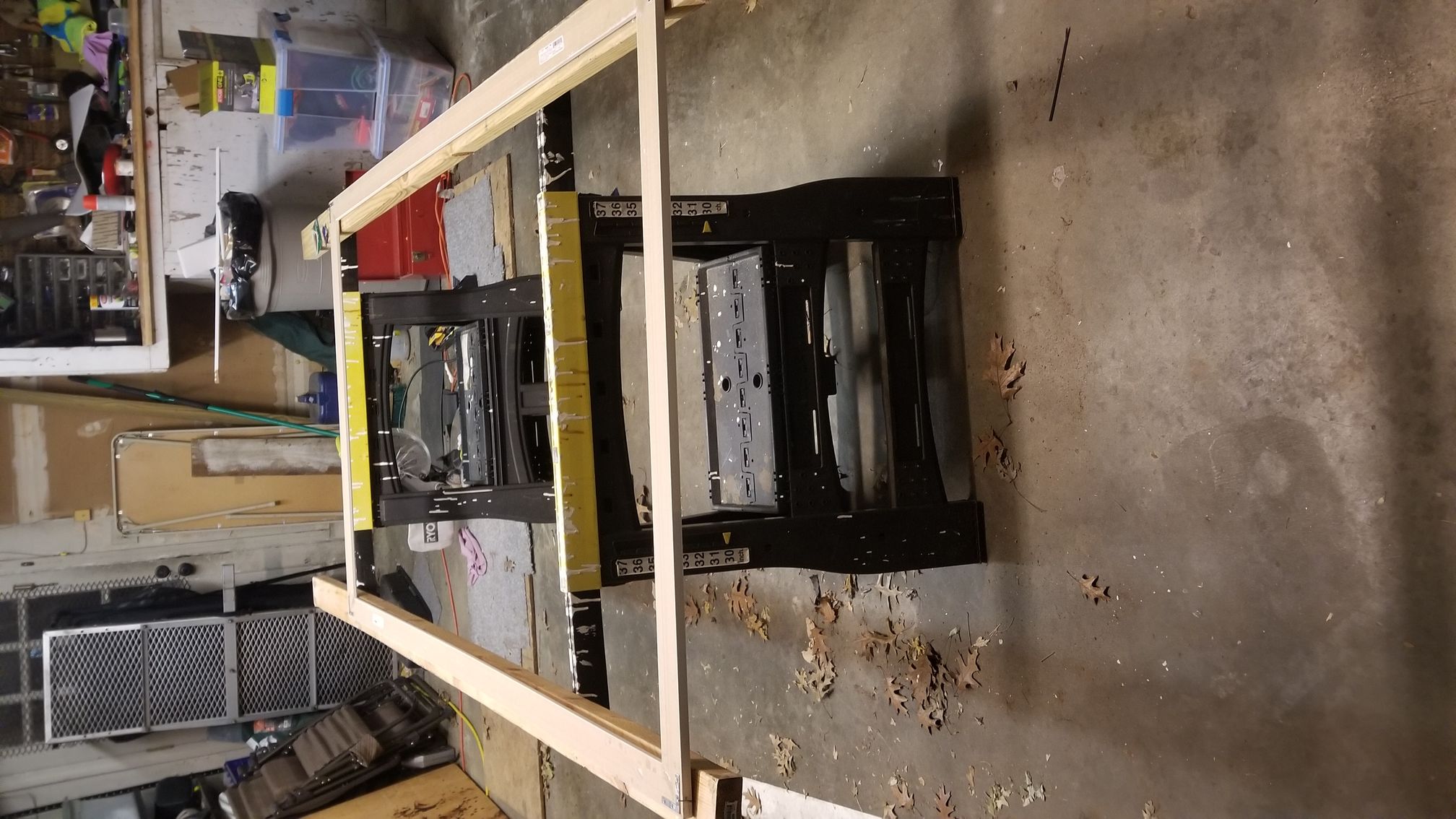
I can't believe this thread came back up. I was just in the process of doing some mental measuring and deciding which maps to order. I have decided I want to piece together a set of Fisher maps and use modge podge glue to stick them to a 1" piece of pink foam insulation so that I can use the pins and string to map all of our trips. I will then build a large frame around the whole thing with cedar.
My question is this, can the maps from the Fisher map book be pieced together the same way a regular F-series map can? How detailed are the maps (campsites and port ages)? How big is each sheet?
My wall is about 2' too narrow to make a complete map with F-series maps. The 2 options I'm considering are the Fisher map book or putting the east and west sections of the BW on "islands" like Hawaii is on a U.S. map.
I can't wait to finally get this project moving!
"Leave it as it is.....The ages have been at work on it and man can only mar it." Theodore Roosevelt
04/20/2015 08:39PM
Since I live in a dorm building right now, I don't have room for a full map but I have the first few sections bought from where I've been so far and plan to get the whole thing!
Of all the roads you take in life, make sure a few of them are dirt.
04/20/2015 08:55PM
DeanL - consider the National Geographic maps too. They make a nice large wall map (you need 2 East and 2 West) and have nice level of detail. That was my original plan before I saw this all-in-one option. I think I'd do that before the Fisher "book" maps. But if you have room for the real fisher maps, go for it!
Maybe we should start a thread of photos of COMPLETED wall maps for comparison. Everyone's preferences and constraints are different - there's no best way that works for all. Would be fun to see options collected in one place.
BlueSkiesWI - you just keep on saving the maps, you'll have wall space some day!
Wherever there is a channel for water, there is a road for the canoe. -Thoreau
04/21/2015 08:15AM
quote BWPaddler: "Creative Laminating in Brooklyn Park MN did it - 5mil thickness. They will do a matte finish, but it is more expensive. They laminated it and put in grommets in the top (3 at my request in brass). So I plan to hang on the wall on three finishing nails. I mailed it to them in the tube it came in (USPS $5.95) and then I went up there and picked it up so they didn't need to roll it again. (open 6-6 M-F) It slid into the back of the Suburban just fine, but wouldn't fit in a sedan I am sure.
I had it on the kitchen table (just barely fits!) and was poring over it, which I can see doing from time to time, so wanted it to go on and off the wall easily.
Glare was negligible when doing that. Not sure what it will look like on an inside hallway wall. Will let you know.
It was packed against a foamboard thing that might come in handy, but I hadn't planned to mount it. Will use grease pencil if I want to mark on it - gonna try that out on the back side.
LOVE IT!!"
Is there a reason you went with the 5 mil instead of the 3? Increased stiffness, or...?
I only have a sedan and I know after having the map on the wall already it won't fit unless I bend or roll it a little. Thankfully I somehow, (don't ask) have two of these maps and it's good thing too! One for the cabin and one for home...it'd be a beast to transport but totally necessary at both locations! So I'm hopefully doing this right the first time as it has double the impact.
"It's a dangerous business, Frodo, going out your door. You step onto the road, and if you don't keep your feet, there's no knowing where you might be swept off to." – Bilbo Baggins
04/21/2015 08:58AM
I guess I did want it fairly stiff to hang on a wall and withstand 3 kids.
But the 5mil can atill be rolled up easily - maybe not quite as tight as it arrived from the artist. I'd be comfortable rolling this with about an 18" diameter to the resulting roll if that helps you plan. I didn't want it curling on the wall (maybe it wouldn't have, I'm just speculating) so I kept it flat afterwards.
You are one lucky duck to have TWO! I will probably end up getting a smaller one for my office some day...
Wherever there is a channel for water, there is a road for the canoe. -Thoreau
04/21/2015 10:31AM
quote BWPaddler: "I guess I did want it fairly stiff to hang on a wall and withstand 3 kids.
But the 5mil can atill be rolled up easily - maybe not quite as tight as it arrived from the artist. I'd be comfortable rolling this with about an 18" diameter to the resulting roll if that helps you plan. I didn't want it curling on the wall (maybe it wouldn't have, I'm just speculating) so I kept it flat afterwards.
You are one lucky duck to have TWO! I will probably end up getting a smaller one for my office some day..."
Thanks!
I only ended up with two because there weren't portages on the first one. Plodder was very kind and sent a replacement with the portages included and also the changed color scheme, but said to go ahead and keep the first one!!! Great customer service and a fantastic product!
If anyone else has one and wants to get it to me this weekend at the MWM expo we can get a lamination discount for doing a bunch at once from the lamination place mentioned above. Just throwing it out there.
"It's a dangerous business, Frodo, going out your door. You step onto the road, and if you don't keep your feet, there's no knowing where you might be swept off to." – Bilbo Baggins
04/21/2015 10:36AM
Oh sure! Get a group discount AFTER I get mine done - ask Shawn if I get a referral fee, lol.
I have to clear space on the targeted wall, but hope to have the whole thing up in the next day or two... and then will have to resist living in the hallway and dreaming. It's been fun on the dining room table and youngest kiddo was checking out lakes she'd like to visit. Maybe by osmosis, it will seep into the older two as well since it will be outside their rooms, ha.
I have to clear space on the targeted wall, but hope to have the whole thing up in the next day or two... and then will have to resist living in the hallway and dreaming. It's been fun on the dining room table and youngest kiddo was checking out lakes she'd like to visit. Maybe by osmosis, it will seep into the older two as well since it will be outside their rooms, ha.
Wherever there is a channel for water, there is a road for the canoe. -Thoreau
04/21/2015 10:53AM
quote bstrege: "I ironed the maps (on low and with a cloth on top of the paper) to try to get some of the creases out. (It kind-of worked - at least made a little flatter and easier to put up.) "
If you iron the wrinkles out of your maps, turn OFF the steam feature of the iron.
05/08/2015 10:03AM
Just FYI, if I were doing it over again, I would have the lamination place install the grommets on top AND bottom. The map is so wide, it hangs a bit away from the wall by the bottom, whereas grommets on top keep it nice and tight.
Wherever there is a channel for water, there is a road for the canoe. -Thoreau
05/08/2015 10:01PM
quote bwbrian: "I've been looking for a full BWCA wall map for awhile and finally found one. I just purchased the wall fabric version of this BWCA wall map last week and put it on the wall in my office today. What a great conversation piece - the first two guys who stopped by wanted to know where to get one for themselves.
Map is 51x29" and covers the whole BWCA - there is also a larger 77x44" version. It was made by a guy in Madison who spent several years putting it all together.
My wife bought me that same map last year as a surprise gift--I love it!
(sorry-I posted my reply before I realized that the rest of the thread was mostly discussing this one map...)
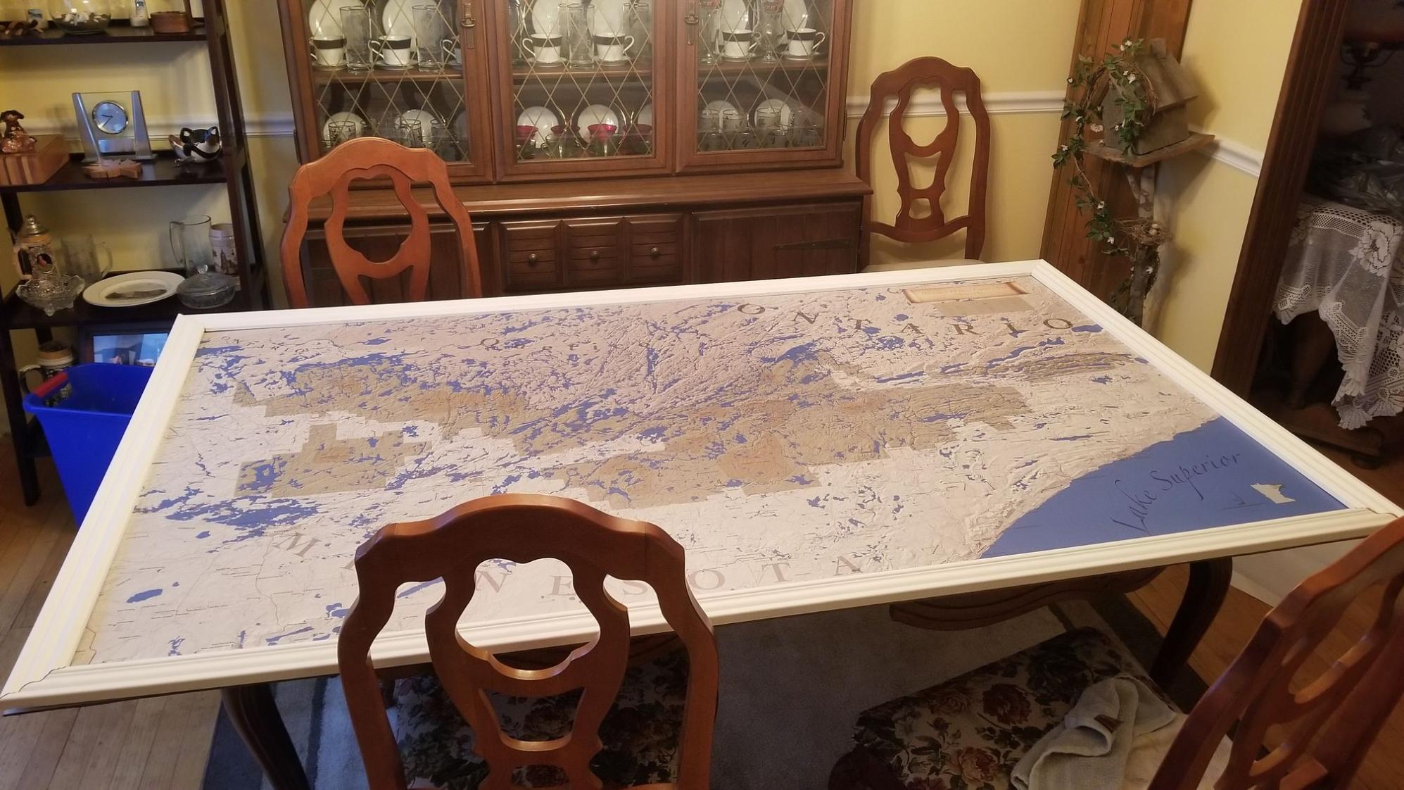
01/11/2019 01:03PM
Folks, I LOVE this site..........
I was looking for a good wall map, and found the etsy site, from posts here. I just got my map.
It is a FANTASTIC map but it does cut off about 1/4 of the upper part of Quetico. That is not a huge deal for me, I will still absolutely LOVE this map.

I plan on using a piece of plexi to stick it to, and then mount the plexi to my wall with a frame around it.
I cannot wait to get it done.

01/12/2019 10:37PM
GeoFisher: "Folks, I LOVE this site..........
I was looking for a good wall map, and found the etsy site, from posts here. I just got my map.
It is a FANTASTIC map but it does cut off about 1/4 of the upper part of Quetico. That is not a huge deal for me, I will still absolutely LOVE this map.
I plan on using a piece of plexi to stick it to, and then mount the plexi to my wall with a frame around it.
I cannot wait to get it done."
Plexi ended up being way too expensive, and way, way too heavy. I used a piece of 4 x 8 dry erase board instead.
When I get the frame built and painted, I will share pictures. Getting that map, all 3 pieces lined up without bubbles, and stuck down was a total BEOTCH.
:)
01/12/2019 10:54PM
GeoFisher: "Folks, I LOVE this site..........
I was looking for a good wall map, and found the etsy site, from posts here. I just got my map.
It is a FANTASTIC map but it does cut off about 1/4 of the upper part of Quetico. That is not a huge deal for me, I will still absolutely LOVE this map.
I plan on using a piece of plexi to stick it to, and then mount the plexi to my wall with a frame around it.
I cannot wait to get it done."
+1 about this site. I post intermittently, but I read a lot of the posts. I also got this Etsy map and had it laminated with the grommets at that place it Brooklyn Park. Turned out great. I have it in my office, and it is a great “break” to look it over. I would not have found the Etsy map or the laminating without the suggestions of this site.
01/15/2019 11:05AM
I've had this map, a large Q map and Wabakimi planning map laminated then use 3m stickers to attach to wall. works very well... but would look better with a frame.
To an earlier point- not sure why the etsy map couldn't shift up and include the Q. it has a lot of map south of the BW which isn't really being used. Wonder if it has to do with map copyrights in Canada.
To an earlier point- not sure why the etsy map couldn't shift up and include the Q. it has a lot of map south of the BW which isn't really being used. Wonder if it has to do with map copyrights in Canada.


01/16/2019 08:18PM
GeoFisher: "GeoFisher: "Folks, I LOVE this site..........
I was looking for a good wall map, and found the etsy site, from posts here. I just got my map.
It is a FANTASTIC map but it does cut off about 1/4 of the upper part of Quetico. That is not a huge deal for me, I will still absolutely LOVE this map.
I plan on using a piece of plexi to stick it to, and then mount the plexi to my wall with a frame around it.
I cannot wait to get it done."
Plexi ended up being way too expensive, and way, way too heavy. I used a piece of 4 x 8 dry erase board instead.
When I get the frame built and painted, I will share pictures. Getting that map, all 3 pieces lined up without bubbles, and stuck down was a total BEOTCH.
:)
"
And I'm finally done.
Here are some Pics:


01/19/2019 08:44AM
GeoFisher: "GeoFisher: "GeoFisher: "Folks, I LOVE this site..........
I was looking for a good wall map, and found the etsy site, from posts here. I just got my map.
It is a FANTASTIC map but it does cut off about 1/4 of the upper part of Quetico. That is not a huge deal for me, I will still absolutely LOVE this map.
I plan on using a piece of plexi to stick it to, and then mount the plexi to my wall with a frame around it.
I cannot wait to get it done."
Plexi ended up being way too expensive, and way, way too heavy. I used a piece of 4 x 8 dry erase board instead.
When I get the frame built and painted, I will share pictures. Getting that map, all 3 pieces lined up without bubbles, and stuck down was a total BEOTCH.
:)
"
And I'm finally done.
Here are some Pics:


"
Very cool! I see my comments from 2015 are back here not far. We have our Etsy map framed and on the wall in our kitchen. The new true north wall map has me intrigued at 8' x 3'
01/19/2019 10:33AM
cyclones30: "GeoFisher: "GeoFisher: "GeoFisher: "Folks, I LOVE this site..........
I was looking for a good wall map, and found the etsy site, from posts here. I just got my map.
It is a FANTASTIC map but it does cut off about 1/4 of the upper part of Quetico. That is not a huge deal for me, I will still absolutely LOVE this map.
I plan on using a piece of plexi to stick it to, and then mount the plexi to my wall with a frame around it.
I cannot wait to get it done."
Plexi ended up being way too expensive, and way, way too heavy. I used a piece of 4 x 8 dry erase board instead.
When I get the frame built and painted, I will share pictures. Getting that map, all 3 pieces lined up without bubbles, and stuck down was a total BEOTCH.
:)
"
And I'm finally done.
Here are some Pics:
Very cool! I see my comments from 2015 are back here not far. We have our Etsy map framed and on the wall in our kitchen. The new true north wall map has me intrigued at 8' x 3' "
Yea, that true north map seems kewl.
I will make another one if we get a map with the BWCA and Quetico on it. As it is my map from etsy only covers about 3/4 of Quetico. It does have some of my favorite lakes, but cuts off north of Kawnipi.....
01/21/2019 09:18PM
I've got the Mckenzie A1 in the basement. Framed and backed with foamboard. Each place Ive camped gets a pin, with more-or-less different colors for different trips. There is something satisfying about the very analog display of a physical pin in a physical map, and I like that I can look at each pin and recall a fun memory of that particular place/day.


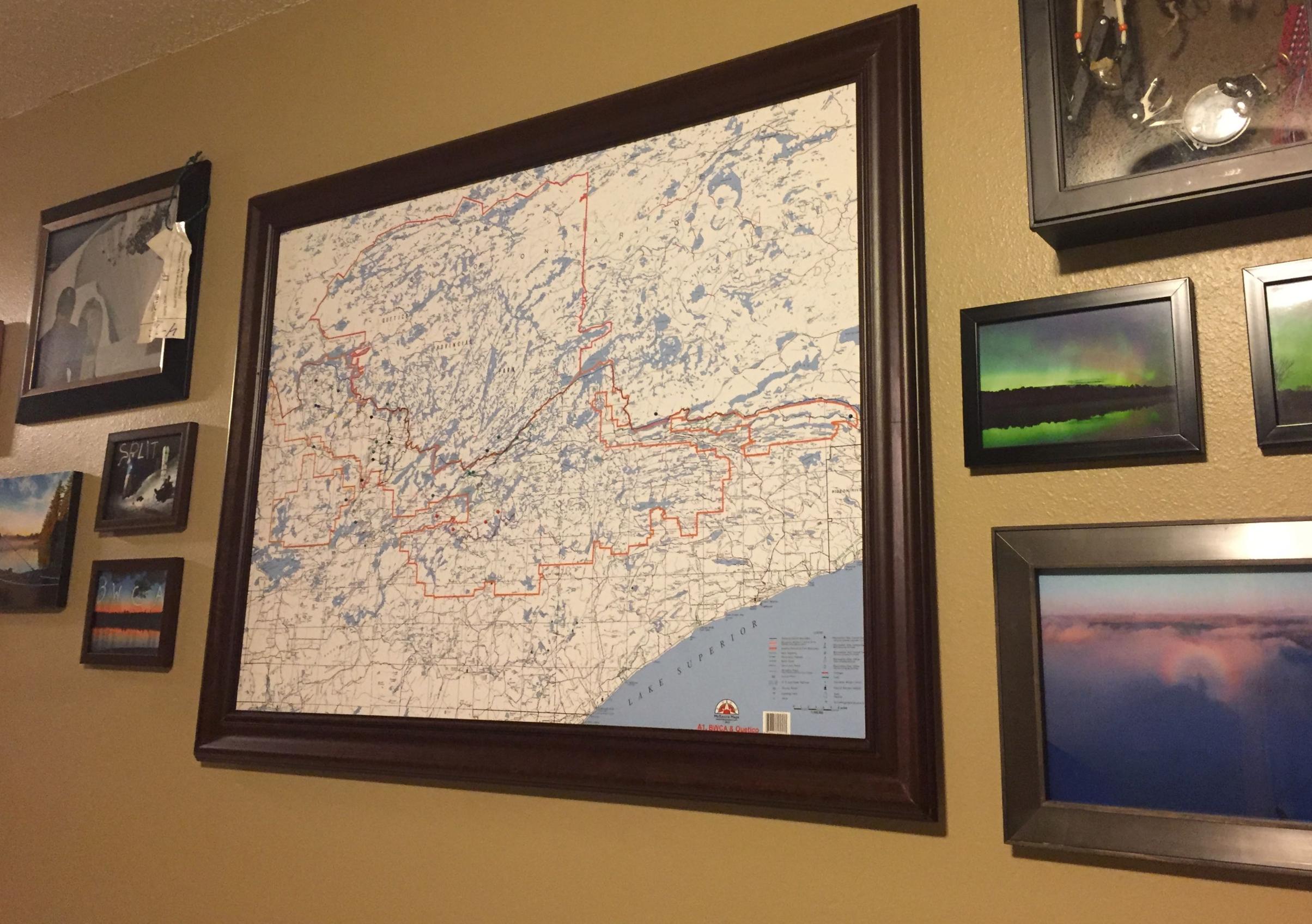

"Everybody needs beauty as well as bread; places to play in and pray in, where nature may heal and give strength to body and soul" -John Muir
02/04/2019 03:18PM
daverr: "For the Etsy map, are the Quetico lakes labeled? I get that there are no campsite or portage information but what about lake names? Thanks!"
No lake names north of the border. It is a very nice map for the BWCA, though.
Look deep into nature and then you will understand everything better ---Albert Einstein
02/04/2019 09:00PM
muddyfeet: "I've got the Mckenzie A1 in the basement. Framed and backed with foamboard. Each place Ive camped gets a pin, with more-or-less different colors for different trips. There is something satisfying about the very analog display of a physical pin in a physical map, and I like that I can look at each pin and recall a fun memory of that particular place/day.
That's pretty sweet. I like that idea a lot. Saw something similar in a rest stop in Canada. Had a world map on the wall and would show all the visitors for that year.
02/05/2022 12:06PM
I picked up one of the large etsy maps years ago.
It was a version that was pretty dark in colors, at the time I thought I would prefer those colors, but things got lost in the display, lake names were too close in color to the actual lake colors. I liked it, but as GIS guy for the last 30+ years, I had some personal critiques about it. It was also pretty dark for the man cave.
That, and with the paper that was used, and the way I had hung it, it would change depending on the humidity, tight as a drum in the winter, kinda drapey come summer.
Then a pipe broke in the ceiling and it got water damaged. But I viewed the mishap as fortunate because I could finally get rid of the popcorn ceiling and do the tin ceiling I always wanted. After a few years I finally decided to replace the damaged map with one of the new offerings.
Went with the sticky panels, and bought a 4'x8' sheet of laminate countertop to adhere to.
Yes, lining those up will test your patience..."Go with the flow Duff." It is not a one person job.
Was able to use the same frame with a little trim job. Finished the project last weekend and added lights (a nice addition to the display). On both maps I used tiny little stickers to mark all of the campsites that I've stayed at.


Subscribe to Thread
Become a member of the bwca.com community to subscribe to thread and get email updates when new posts are added. Sign up Here
 Search BWCA.com
 Donate