|
11/28/2019 11:38AM |
|
04/16/2020 07:43PM |
The entry is a bit further north but would give me an opportunity to explore a bit of the norther Flindt river system and skip a few portages (along the Smye creek entry) that I've done three times before.
|
11/28/2019 02:46PM |
Going up the 702rd north of the First Nations village. Put in at Smye and along the creek, lake-hopping to Wilkie. Good 4 star site (for Wab that is). On through Flindit-Gault-Stump along Allenwater to Windfall. Probably have to cut my way to Daggert if I remember correctly eventually reaching Granite...or not. Depends on the state of the portages, weather, my expectations. We'll see. Just a route I feel that I want to give one more try before moving on to others.
|
04/11/2020 08:28AM |
|
04/15/2020 03:55PM |
Wabakimi is certainly worth the effort whenever you're up for the challenge. I'm just hoping that this summer there will be paddling opportunities up there!
|
04/15/2020 08:23AM |
|
04/15/2020 03:29PM |
HighnDry: "I'm sure Goatroti will respond but per the CA website: 6 months .
Plus however many days/nights you want to pay for permits!"
Thanks! I don't have to pay because I am the Cedar Queen. Man's laws don't apply......sorry, couldn't resist. Thanks for the info.
One more year and I have summer's off and will be teenless.
|
04/17/2020 03:14PM |
I have lost that one so I can't do it.
|
04/15/2020 10:53AM |
P.S. And I can remember the red skies from the airborne ash and soot from the summer of 2011 fires. We were on the Albany River from Miminiska Lake through Petawanga Lake the same time Mike was in first to second week, and the sunsets were red and orange and gorgeous. There was a fire on the Albany between Pickle Lake and where we were paddling that consumed over 100,000 hectares.
|
11/28/2019 12:02PM |
Will this be a solo?
|
04/13/2020 08:22AM |
Phil's comments to you are appropriate since he probably knew more about the entire Wabakimi area than anyone else. So keep tracking down any outfitters since they will know their area of operation well.
And if you do this trip please consider submitting a trip report to FOW so they can add your info to their database. Look for their trip report outline at their website.
|
11/29/2019 11:10PM |
|
04/18/2020 10:20AM |
It is gone now.
The 4 whl track into the parking area is not graded regularly, but the two tracks are well defined.
The parking area was graded by a bulldozer sometime prior to 2015.
I think Ont MNR actively maintains the gravel parking area, but I'm not sure.
Someone does maintain that area at least once a year.
I do know that the 4Whlr track into the put in is used regularly. Both times I have carried my stuff into the put in there have been fresh 4 whl ATV tracks all the way into the lake.
Looks like parking near Sassenach is more accessable than I previously thought.
|
04/17/2020 10:48AM |
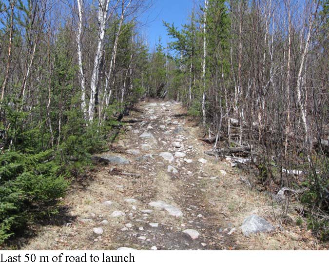
I thought the whole 1.7 km from the 702 Rd into Sassenach Lake was rough, not just the last bit. Perhaps I have that wrong...
May have to go check it out for myself, if they ever re-open the border.
|
04/17/2020 08:30PM |

Gravel pit where you park:

Smye lake put-in:

|
04/11/2020 03:28PM |
He successfully hitchhiked back to Savant Lake and reunited with his vehicle. There have several others skirting the area that I'm interested in but not specifically on the set of lakes that I would like to traverse.
I think Uncle Phil put it best several years ago when commenting on my intended east-west trip in that area that it's seldom traveled. He suggested getting a hold of Eco Lodge since they bought out the outfitters' fishing lodge on Windfall. That is probably my next step to see if there is/has been any maintenance on the route leading out of Windfall into Snake and further east to Granite.
Trying to track this info down is keeping me busy. There are some interesting old mining maps/surveys of that area that I've dug into. No luck yet!
|
11/29/2019 11:34AM |
|
04/21/2020 05:49PM |

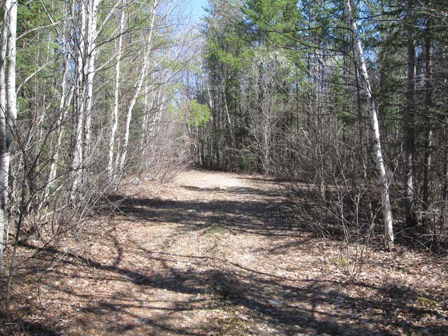
It's a shot of the 702rd looking north from the Smye entry. Most of the road is in this type of shape due to the grading done on a regular basis.
|
04/18/2020 06:23AM |
HighnDry: "jcavenagh: "Hey, Terry - Why don't you post the photo of the track from 702 into the Sassenach entry.
I have lost that one so I can't do it."
Absolutely! It's taken me about a week to figure out how to get the photos out of the pdf from the park that you shared with me. Let's see if these turn out....
This photo was taken off of the graded 702rd looking into the Sassenach lake entry road. This road runs for about 1.7km (1 mi+) to the last 50m shown in the photo below:
"
If the whole 1.7 km is like that first photo...then no worries!
|
04/15/2020 01:21PM |
After COVID-19 restrictions are lifted, how long could an American slog about the Canadian wilderness? What is the limit to number of days?
|
04/13/2020 12:24PM |
|
04/14/2020 09:18PM |
|
04/10/2020 08:19AM |
|
04/15/2020 07:36AM |
Jackfish: "Hey HnD... the guy who did the long solo in Wabikimi wouldn't happen to be Mike Kinziger, would it? He's an old college professor of mine who did a 23 day solo there and wrote a book about several of his solo trips, including WCPP, Opasquia and Quetico, besides WPP. Just wondering if you didn't hit a "4" instead of "2" in your post."
Hey Jackfish, I stand corrected. You were right! Here's Mike K's trip report: The 23-Day Solo in Wabakimi.
This was a very powerful read. I'd like to replicate his trip report style -- not to mention his mental toughness and determination to finish his route. Some of the conditions he encountered probably would have turned me back!
|
04/13/2020 02:51PM |
|
04/17/2020 08:44AM |
HighnDry: "I'm also considering entering at Sassenach lake (Km59) instead of Smye Lake (km43). I'm going to post coordinates for the entry that I received from jcavanaugh that was sent to him from the park office in Thunder Bay.
The entry is a bit further north but would give me an opportunity to explore a bit of the norther Flindt river system and skip a few portages (along the Smye creek entry) that I've done three times before."
I've not been to Wab yet but have the planning map on the wall. Will get there this year or next or both, probably solo. Would likely enter somewhere in this area as well.
Based on the daunting descriptions of the Sassenach lake 4x4 road/entry, I would think it might be worth investigating the next lake north, Valley Lake, as well...though it looks like there would be a 50m chokepoint between Valley and Sassenach to negotiate. There appears to be a logging road that runs just north of Valley, similar to the one running just north of Sassenach. Looks to connect to Valley at 50.487265, -90.220957. Who knows, could be better or could be far worse.
Would love to hear what you learn!
|
04/13/2020 02:09PM |
I recognize the name and I would love to read his reports! It definitely wasn't him and I wish i had saved the other trip report because I'm having a devil of a time retrieving it! I've found some interesting trip reports from another site that cover some of these portages so I'm making slow and steady progress collecting intel.
Allanwater-Lookout-Kopka route
The report covers essentially the Allanwater confluence just east of where I'd enter the river (Stump Lake) and continues through Windfall, Snake and Dagger. That's the meat of it. I think there's a long portage out of Dagger then to meet a stream that flows into Ottertail flowage towards Granite. I haven't seen anything on that but it's mostly because folks have tended to head north out of Dagger into Jeep and Brennan on their way to Wabakimi lake.
The search continues....
|
04/15/2020 01:27PM |
Plus however many days/nights you want to pay for permits!
|
04/17/2020 09:21AM |
For Valley, here's a link to a friend of mine's video. He and i had entered Smye for a trip and afterwards he traveled further up the 702rd to scout out a couple of places to enter.
|
04/17/2020 08:20PM |
jcavenagh: "Hey, Terry - Why don't you post the photo of the track from 702 into the Sassenach entry.
I have lost that one so I can't do it."
Absolutely! It's taken me about a week to figure out how to get the photos out of the pdf from the park that you shared with me. Let's see if these turn out....
 This photo was taken off of the graded 702rd looking into the Sassenach lake entry road. This road runs for about 1.7km (1 mi+) to the last 50m shown in the photo below:
|
04/13/2020 03:55PM |