| Author |
Message Text |
|
Tony
|
Mostly use just Maps. Once in a great great while I'll pull out the compass.
Tony
|
|
straighthairedcurly
|
Map and compass only. I have been using them since I was 13, and have never had an issue so I see no point in switching. I have traveled throughout the BWCA and lots of Canadian lakes and rivers even all the way to Hudson Bay on map/compass only. Even when we went into the Hairy Lake PMA, we stuck with maps showing detailed contours for figuring out where we should start looking for a way to bushwhack through.
I really have yet to understand a need for a GPS in the BWCA or Canadian wilderness areas. A GPS needs batteries and is heavier than a map.
My son had a chance to see the limitations of electronics when we were hiking in a Texan State Park near Austin. We had picked up one of the park's very basic trail maps as we entered the park. As we were hiking along, a group of 6 twenty-somethings ran up to us frantically and asked if we knew where the trailhead was. "Which trailhead?" I asked since there were about 4. I got blank stares back. Then they explained they had been using a map on someone's phone, but the battery had gone dead, and they were now lost. I asked if they drove a maroon Jeep. Fortunately that was there car, and I had seen it at the trailhead where we had started. So we sketched them a basic map of the turns they needed to take to get back to the vehicle. As we sent them on their way, I turned to my son and asked, "Do you think you will ever go hiking without a paper map?" "Not ever, mom, not ever. They were idiots."
|
|
AdamXChicago
|
Northwoodsman: "Cedarboy: "Map and compass. If I want to mark a fishing spot we just mark an "x" on the bottom of the canoe.
CB"
I do the same thing when ice fishing, I make an "X" with a couple of sticks on the ice so that I can find that same spot next year."
Hilarious!
Typically just a map guy here. Have used the compass sparingly. I’ve been bringing along the GPS the last five years and have referred to it a couple of times when I was “aggressively exploring “ :)
|
|
bottomtothetap
|
4keys: "Map only (we do bring a compass, but really haven't needed it in 30+ years). On lakes with a lot of little islands and bays it can get confusing if you're not paying close attention, but that's part of the adventure!
"
+1
|
|
RetiredDave
|
I use only a map and compass, Boy Scouts taught me so much many years ago! Before my trips I draw point to point lines on my map (big lakes only), and I write the degrees from zero on the map. That way I can stop and check myself when the shore and portage is in the misty distance.
One time I was being buffeted and thrown around by winds, so I took shelter for lunch at an unoccupied campsite. When I set to start out again, my gut told me to go one way, but my compass told me to go another. Thankfully, I followed my compass reading, which, of course, was correct.
Having said that, I would certainly use GPS if I had access (don't own a smart phone). I simply have never felt the need for one when I have my map and compass. By the way, I carry my compass everywhere because so many people tell me to 'get lost'.
Dave
|
|
MidwestFirecraft
|
martian: "Does Backcountry Navagator Pro count? "
Great app for Android users, highly recommend it. Didn't work so great on friends iphone.
|
|
moray
|
Map and compass. I had to use the compass for the first time this fall. When we arrived at Snowbank entry the fog was so thick you could barely see front of the canoe.
|
|
HowardSprague
|
I’ve never tried GPS, unless you count the talking lady navigation on my cell phone while driving. And even with that, i sometimes give my wife a hard time because she can’t be a regular navigator for me and follow a map.
|
|
MikeinMpls
|
Wow! What a huge response. Although not scientific, there appear to be many more map-only trippers than I thought. Like I said in my original post, I'm map only. I take the compass out once in a while, mostly to insure I'm traveling in the best line I can. It's what I learned in the army and it kind of stuck with me.
Like others, I have come across other trippers in the BWCA who have asked me where they were on their map. One group I met in July had only a hand-drawn map on a piece of paper! I met a group on Clove Lake once who asked me where they were. I pointed "over here" with my finger in the air about six inches off their map page. No wonder they were lost...they were off the map page.
I think map and compass is a dying skill. I suspect there are many more GPS users than map and compass users. Learning to read a BWCA map, learning to orient the map, and using a compass with the map is easy to learn, I think, but it has to be taught. Hopefully senior trippers will pass the legacy on.
Mike
|
|
Bearpath9
|
I bring both, but really only use the map. I bring the compass so my grandson can get at least a rudimentary idea on how to use it. First time we went, he pointed out that he had his phone, so why did he need to learn how to use a compass, and I basically laid out several scenarios where his phone was no longer working. Being a teenager, he had several rebuttals, but I will say that now he knows how to use a compass. Not an expert by any means, but he can do it.
|
|
mgraber
|
Map, compass, and the last couple of years a GPS as back-up. We mostly just use the GPS to mark mid lake fishing structure, and occasionally turn it on for the shortest possible route across a large body of water or to confirm exact location, etc. If forced to choose, it would be map/compass by a mile. GPS can never give you the "big picture" like a map can, and will never be as reliable. I feel like a compass is necessary in order to keep an exact heading on large complicated bodies of water, not necessarily to avoid getting lost, as that is unlikely if you have a good sense of direction. I know many don't mind taking their time navigating or following landmarks, etc. but our goal is fishing and being sure that we save every possible moment and every ounce of energy for fishing. A compass can shave off considerable time for most people as can a GPS. I would just never rely solely on an electronic device, and really enjoy maps.
|
|
Michwall2
|
Mostly map and compass. I carry the GPSr to check once in a while. I learned to read the map and stay found before I obtained a GPSr. I still prefer that paper maps. There are also places in the BW where a compass is not accurate. If I were skeptical of the reading, I would move a hundred feet (or more) and try again. The amount of minerals in the rock can mess with a compass reading.
|
|
BnD
|
Map, GPS and compass. I preload shortest travel routes, fishing spots, etc in the GPS. I have it mounted to the thwart in front of me tracking all the time when we’re traveling. If we’re just fishing I don’t use it other than to mark more fishing spots. I always have the map hanging in front of me on the thwart in the map case. The more you use a GPS the handier it is. You are NEVER turned around and losing time/ wasting energy. The eye in the sky always knows exactly where you are.
|
|
OldGuystilltripping
|
I've always used map and compass. Maps are always open in front of me but when you cross big lakes, particularly if they have islands, a compass is very reliable to places ahead you can't see. I used an iPhone map many years ago and looked at it the first night out to see if I could use it. I never opened it again until the 8th or 9th night out and the phone was dead. Besides the thought of dropping the gps in the water or other reason it might not work I would never go without maps and backups.
|
|
butthead
|
I make my own maps on my computer.  Left is a 13x19 inch map right is 111x8.5. Custom for each trip and match the maps on my Garmin 62st. So I use both all the time. Left is a 13x19 inch map right is 111x8.5. Custom for each trip and match the maps on my Garmin 62st. So I use both all the time. 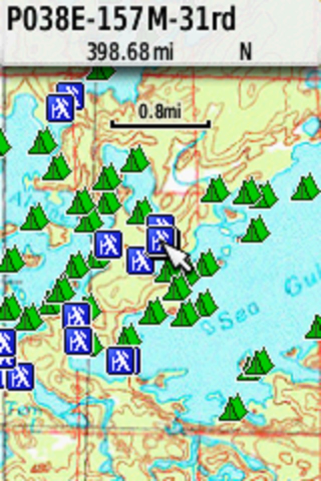 screenshot of my GPS, Seagull and Alpine. Use base maps USGS down to 7.5 quads and NRC Canada, also have files containing NOAA Harbor charts, and satelite imaging. I can copy a paper map and orient it in Google Earth then import it and overlay on top of a base map. screenshot of my GPS, Seagull and Alpine. Use base maps USGS down to 7.5 quads and NRC Canada, also have files containing NOAA Harbor charts, and satelite imaging. I can copy a paper map and orient it in Google Earth then import it and overlay on top of a base map.
Compass? Several, but I have one in each pack and on my PFD,s plus one handy in my pocket.
butthead
|
|
Blatz
|
Map 99% of the time. I'll use Garmin Earthmate on my phone for confirmation from time to time. Using a map and compass in the BW lakes is easier than over land.
|
|
martian
|
Does Backcountry Navagator Pro count? Between a
Map,compass and this app helps us get around ok so far.
|
|
jcavenagh
|
I am a map and compass only guy. I always have 2-3 compasses in my kit, one on a lanyard around my neck, another in the pocket of my PFD, and one more in a pack.
I have this irrational fear of getting truly lost... but have been "unlocated" only a couple times. AndySG knows how I am then. >:-(
|
|
arctic
|
Maps. GPS is more a novelty item.
|
|
BnD
|
GPS is a novelty?
|
|
TrailZen
|
BnD: "GPS is a novelty? "
While I don't see GPS as a novelty and frequently use it on hikes and in trail design, I've used only map & compass in my 40+ years of Canoe Country travel.
TZ
|
|
BnD
|
To each their own and yes I’ve been taking trips since 1992 with only maps and compass until 2013. I can absolutely tell you they are time savers if setup correctly with background maps waypoints, back tracking and routes. I still have all the maps and compass x 2 with me and my bow paddler has a full set of maps to follow along as well. IMO definitely worth the pack weight and we are single portagers so that’s sayn something since a lot of “extras”were left behind years ago.
|
|
Jackfish
|
4keys: "Map only (we do bring a compass, but really haven't needed it in 30+ years). "
What 4keys said. Following shorelines and landforms on your map can actually be quite easy... and my maps and compass have never run out of battery. :)
With that said, I've never owned a GPS, but if (when?) I do someday, I'll probably use it occasionally. Any GPS that I buy would not be purchased for it's GPS function first. It would be for communication, like a Garmin InReach or 66i.
|
|
mmrocker13
|
We are map-only users. I did get an InReach this year, but the only time we turn it on is if we check the weather. I HAVE maps on my phone/GPS...never used them.
|
|
NordSteve
|
I love technology, but on our recent trip we used printed maps to navigate. It was my wife's first trip and I wanted her to learn navigation by map in case for some reason she needed to move solo. Note the fancy home made map bag (the radio is a Yaesu FT-60R for emergency use and listening to the NOAA weather reports. ) )
Of course we had other options for navigation. In addition to the original maps, we had two sets of b/w photocopies in zip-loc bags in two different packs. We brought one iPhone 11 as our backup GPS (did not use it to navigate) and picture taking camera (did use it). And we had a 20000 mAh charger to recharge the phone if needed. Didn't need to -- left the BWCA with 40% charge on the phone (all radios off in the phone).
Aside - one benefit of bringing the phone is the fitness tracker integration, capturing data on portages. This is the one I was really interested in reviewing later. 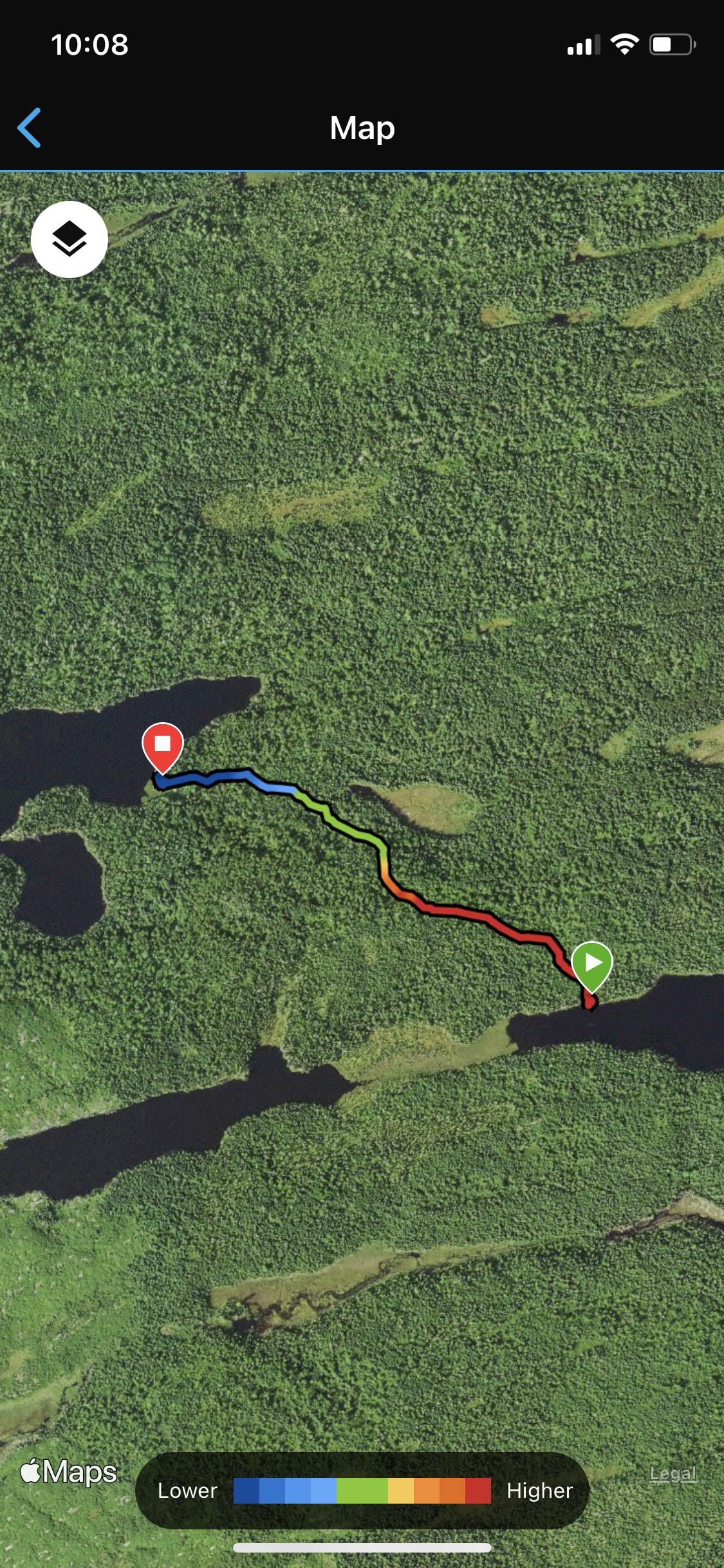 
|
|
MN_Lindsey
|
BWCA, map exclusively.
VNP - GPS almost exclusively, map for fun.
|
|
ducks
|
Map and compass only. But I’ve never used the compass and that’s probably because I haven’t traveled any big lakes.
|
|
okinaw55
|
Have always been map and compass but this year bringing the gps as well to try. I'll be keeping up to date on both as we move. Sometimes after a long day, I tend to start second guessing what I've plotted on the map. Islands I wasn't expecting and getting turned around happens to me at least.
|
|
marsonite
|
Another map and compass guy here. I used a gps in Wabakimi, and it came in handy sometimes, but mostly I have the map out and just follow where I am as I go. I recently made a trip into Crab, and I did cheat and keep my phone on with my Topo map app open so I could find my way to the portage more easily.
I have gotten mixed up a few times, and a gps would have come in handy, but mostly I think in a place as well mapped as the BW, they are a fun thing to have along but really not a necessity.
|
|
bwcamjh
|
I was gifted a fancy gps....more sophisticated than I am and I haven't learned to use it properly.......
Map and compass has really never let me down......
Works for me...
|
|
dogwoodgirl
|
Pretty much map only. My son brought a GPS on our last trip, and consulted it once, on Insula at the end of a very long day when we were both uber-tired and hangry, and he wanted to resolve a dispute about where we were. The map (read Mom) was right.....
|
|
MikeinMpls
|
I am curious how many paddlers use a map only, versus a GPS unit only, or a GPS with map backup. I used a GPS once, with a map as backup...it didn't help me much. Granted it was a while ago when GPS downloads, screens and features were much less sophisticated than they are now.
That said, now I travel only with a map and compass. I have my compass velcroed to the thwart in front of me, and a map on the back of a pack that I use to make sure where I am at all times. Like many, I orient the map to the direction I am traveling, and associate the terrain with the map. I always like to know where I am. I always bring a back-up map.
Curious....any map-only users? If so, had you tried GPS and gone back to maps? I'm wondering also if map reading is becoming a lost art with GPS units becoming more common and advanced.
Mike
|
|
nctry
|
Actually in the BW’s using the various maps we’re pretty spoiled. They almost hold your hand as you go. The trick is what I here people say... stay found. My first experience in Canada using plain topo maps (well marked ahead of time) I lasted two days! I came out tail between my legs and went home and seeked how to really read a map. A few weeks later I went back and had hardly a problem. The last few years up there I used a gps also... but that was mainly to find unused trails that our friend Marten “found” and made tracks. Using a gps in the bwca would be a good way to learn how to use one. I hint any method is fine... unless your lost and your kid is in the middle of a game he found on it. Haha!
|
|
moosedoggie
|
I use a map and compass to navigate while traveling and a GPS to mark my fishing spots and as a backup.
|
|
Geocellostrong
|
Map and compass only. And I keep the map oriented north up to force myself to think differently. And honestly, unless I get really confused, I barely use the compass in the BWCA. It’s easy enough to follow the lakes. Where I live in CO, however, I am always using the compass as it’s much easier to get lost without the lakes as reference.
|
|
prettypaddle
|
Map and compass only here. Map reading may be a dying art, but we're doing what we can to keep it alive! We happened to have four maps which covered the area of our day trip so everyone has one and is more or less following along ;)
|
|
analyzer
|
Map. I bring a compass, but don't use it. It's more for bushwacking. IF I go walking off in the woods, I want a compass with me. On water, it doesn't seem to be necessary, we just stay focused on the map, and always keep track of where we are.
Having said that, we did miss a turn between pocket and Gebe last year, but figured it out pretty quickly. But not before making a crappy portage over a beaver dam, and down a rock garden, and then discovered that wasn't a portage, and wasn't the right direction.
For BWCA, It's still maps for me.
When we're scouting in the woods for deer hunting,however, the GPS helps alot.
|
|
MichiganMan
|
I'm impressed with the number of map readers! I'm the same- map only. Bring the compass but never use it. Back in the world I'm on my phone and computers so much that it is very nice to not use electronics in the bush.
|
|
airmorse
|
4keys: "Map only (we do bring a compass, but really haven't needed it in 30+ years). On lakes with a lot of little islands and bays it can get confusing if you're not paying close attention, but that's part of the adventure!
"
+1
|
|
kjw
|
Map and compass. Also, have Boundary Waters and northern Minnesota downloaded as offline file to my phone (using Google Maps) to be used in case I am unsure where I am at. I put my phone in airplane mode and use Google Maps. This offline map also helps if you are driving on roads and have no cell signal as your Google maps will still work.
|
|
Northwoodsman
|
I use maps for navigation and GPS for verification. GPS is really nice when trying to locate an not-so-obvious portage or campsite. When the bow paddler says " I think it's right over there", and I ask "Are you sure", almost 100% of the time the bow paddler asks "What does your GPS show?".
|
|
Nigal
|
I always have and always will carry a paper map. Having said that I got the National Geographic bwca electronic maps for Avenza app and I used it more than the maps this year. Normally I have Avenza maps as a confirmation for my paper map reading but I end up using it way more than I plan to.
|
|
Cedarboy
|
Map and compass. If I want to mark a fishing spot we just mark an "x" on the bottom of the canoe.
CB
|
|
4keys
|
Map only (we do bring a compass, but really haven't needed it in 30+ years). On lakes with a lot of little islands and bays it can get confusing if you're not paying close attention, but that's part of the adventure!
|
|
Heyfritty
|
I’ve always been map and compass only. My son was the leader for our trip this year and was perfect with the map. There was one tricky spot where he saw a portage we didn’t want to take, but a minute with the map and compass and he ruled it out. I brought my GPS for the first time in order to mark fishing spots, but unfortunately didn’t need it.
I take the GPS deer hunting to mark waypoints, but only use it to see how far I am from my point of interest. I use my compass to guide my movements.
Fritty
|
|
Savage Voyageur
|
I first learned to read map and compass on my first trip to the BWCA. After a few trips I moved from the crunchy Fisher maps to USGS Topographic maps and my trusty Silva compass. Somewhere around 1985 I bought a Garmin 12XL basic GPS. I used it to verify my position on the maps. I upgraded my Garmin for a newer model that showed maps. I still used maps and compass in the BWCA. Then I bought a Garmin Montana 650T and a USGS Topo map chip with it. It has great battery life and it shows portages and campsites. So as I’m paddling I just watch the moving map on my GPS. I still bring a map and compass but I usually don’t bother taking them out of the pack. Using a GPS with a good map is how I navigate now. It really works great on lakes with a lot of islands or bays. It also works great if I use it with a route I made. I don’t pay much attention yo where I’m at anymore because the GPS is now doing that for me.
|
|
nctry
|
Many posts say they use map and compass... but say they never use the compass. That’s just reading the map. Map and compass is a bit different in my book. With map and compass, you're looking at your compass as much as your map. There was a gal on the challenge (from Florida) who tried to solely use a GPS. It was not making sense trying to follow the international border. She finally quit... no maps!
Savage here knows map and compass... with the likes of the Fisher maps, we get by with just the maps because there are so many references such as campsites and portages. I think the future is GPS, but maps never go dead! Think for planning, and backup maps will always be needed, too, as well as compass.
|
|
OldTripper
|
I bring both - maps and compass.
Like some others, I use only the map though, most of the time.
Have never taken a GPS.
|
|
MidwestFirecraft
|
Moved to mostly GPS in expedition mode. Always look at the lake before starting and have the mental picture in my head. If needed, just touch the power button and the map pops up. Can be used like a map and compass as well. On lakes like Insula in the dense fog and PMA's it has been priceless to me.
|
|
cyclones30
|
Every trip so far is paper maps only. No gps, no compass and do just fine.
|
|
Northwoodsman
|
Cedarboy: "Map and compass. If I want to mark a fishing spot we just mark an "x" on the bottom of the canoe.
CB"
I do the same thing when ice fishing, I make an "X" with a couple of sticks on the ice so that I can find that same spot next year.
|
|
Banksiana
|
Map or memory. Bring a compass along but haven't taken it out of the pack in at least twenty years. Don't think I've bothered taking out the map in at least four or five years either.
|
|
Savage Voyageur
|
I've taken the four part online training courses from the military two different times. It was kind of difficult the first run and I didn’t score as high as I wanted. It covers everything navigation wise. So I studied and took it again and was satisfied with my score. I can now call in mortar rounds using compass bearings or mils, haha.
I agree, Ben, that GPS is here to stay. My moving map is always on target. No more questions about where we are on a lake like Sag or Knife with lots of islands or bays. I will start a thread later this week for anyone interested in the course that I took. Might be of interest to someone here.
|
|
Cedarboy
|
Northwoodsman: "Cedarboy: "Map and compass. If I want to mark a fishing spot we just mark an "x" on the bottom of the canoe.
CB"
I do the same thing when ice fishing, I make an "X" with a couple of sticks on the ice so that I can find that same spot next year." c
Have to remember that this winter, lol.
CB
|
|
Spartan2
|
Our last canoe trip was 2013, and as always, Spartan1 was the navigator. Map and compass. He had some orienteering training in the Army, and he has good skills with the map plus the compass. I felt very confident on all of our trips with him doing the navigation, but I almost always had my own map to follow along. We never got "lost", although I will confess we were "temporarily misplaced" a few times in four decades of tripping. Never anything serious, though. Just annoying.
When I retired from my public school job in 2004 my colleagues gave me a GPS as a retirement gift. I tried to act enthusiastic, but I never had any desire to learn how to use it and I bartered it on this website for some leather goods from Dicecupmaker a few years later. Just didn't feel a need to have one.
|