| Author |
Message Text |
|
billconner
|
Agree. From Little Gabbro to Kawishaiwi is a rough ride on either side. I can't imagine anyone paddling the other way.
|
|
eagle98mn
|
billconner: "Agree. From Little Gabbro to Kawishaiwi is a rough ride on either side. I can't imagine anyone paddling the other way. "
Can you please clarify this? I'm not familiar with this area, but I'm considering the it this year. Should I not be targeting the 122 rod portage in OldGreyGoose's photo at all if I am headed south to north? What about north to south? Or does this entire discussion revolve around the channel to the west of that portage and the channel to the NE of that portage? I'm a little lost by what is and isn't safe in this area!
The 122 rod portage looked liked the straightest shot to head north to Clear Lake from Little Gabbro, but I'm not interested in playing games with my kids' lives. Thanks in advance!
|
|
Cc26
|
The portages are there for a reason!
|
|
billconner
|
Use the portage. Clear and nearly level. I tried to say you can't paddle south which is upstream, and I'll never consider floating north. I'd call them rapids but that's my view, not an official rating. People do float or try to the western route downsteam but I advise strongly against it having done it once. We did not remain in canoe for much of it.
The portage has a number of side trails to overlooks of the stream and various falls which I recommend making time for.
|
|
eagle98mn
|
billconner: "Use the portage. Clear and nearly level. I tried to say you can't paddle south which is upstream, and I'll never consider floating north. I'd call them rapids but that's my view, not an official rating. People do float or try to the western route downsteam but I advise strongly against it having done it once. We did not remain in canoe for much of it.
The portage has a number of side trails to overlooks of the stream and various falls which I recommend making time for."
Thanks! I appreciate the clarification.
|
|
ZIMTLSA
|
Most certainly use the portage. The dangerous waters marking is certainly true. Good fishing though along that section and many short trails off the portage to fish from.
|
|
bloody stump
|
USE THE PORTAGE!
My partner and I tried to avoid the portage and went a ways down the west side/channel....got a ways down and it was obvious we didn't want to continue (this was early may w/ high water). the paddle back up is one of the scariest paddles i have had, the current was very strong and a few 'shoots' you need to go back up...we made it back up but I wont try a short cut again after that experience.
|
|
OldGreyGoose
|
Cc26: "The portages are there for a reason!"
Brilliant!
Can someone delete this thread now, please???
(Unfollowing)
--Goose
|
|
OldGreyGoose
|
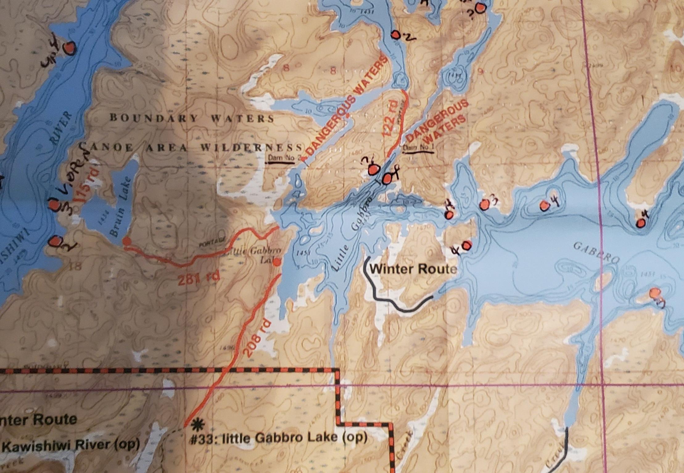
Planning a May BW trip and was wondering if there are any good stories or valuable info about the "Dangerous Waters" spots on the McKenzie map 18 (Lake One)? Is this supposed to warn people off? Is it a carryover from days past, or what? Thanks in advance.
--Goose
|
|
Blatz
|
This picture was taken at a dangerous water location 
|
|
cyclones30
|
Sounds like a spot where if you got sideways you might go in and not get all your stuff back...including the canoe.
|
|
cowdoc
|
Fast, skinny water with a pretty good drop. If I recall, there is even the remnants of some type of old sluice in there from days past. The portage is fine.
|
|
OldGreyGoose
|
cowdoc: "Fast, skinny water with a pretty good drop. If I recall, there is even the remnants of some type of old sluice in there from days past. The portage is fine."
Not planning on taking that long portage if I can avoid it.
|
|
Spartan2
|
Disregard. I hadn't looked at the map before I posted.
|
|
OldGreyGoose
|
I should point out, that coming from the North (off the shown map) you can paddle either side of the narrow portage peninsula. It seems the portage is more "convenient" for travel on the West side, allowing you to avoid the 2 very short portages (hard to see on the map) there. If you were heading to or from Lake One to the NE, it's a straight shot down the right side thru the Dangerous Waters area.
|
|
OldGreyGoose
|
Just got this from Mark at CCO:
"The dangerous waters marking just warn people not to take their canoes down the rapids, especially those particular ones. I do remember a gal that lost her life while going down one of those rapids."
|
|
cowdoc
|
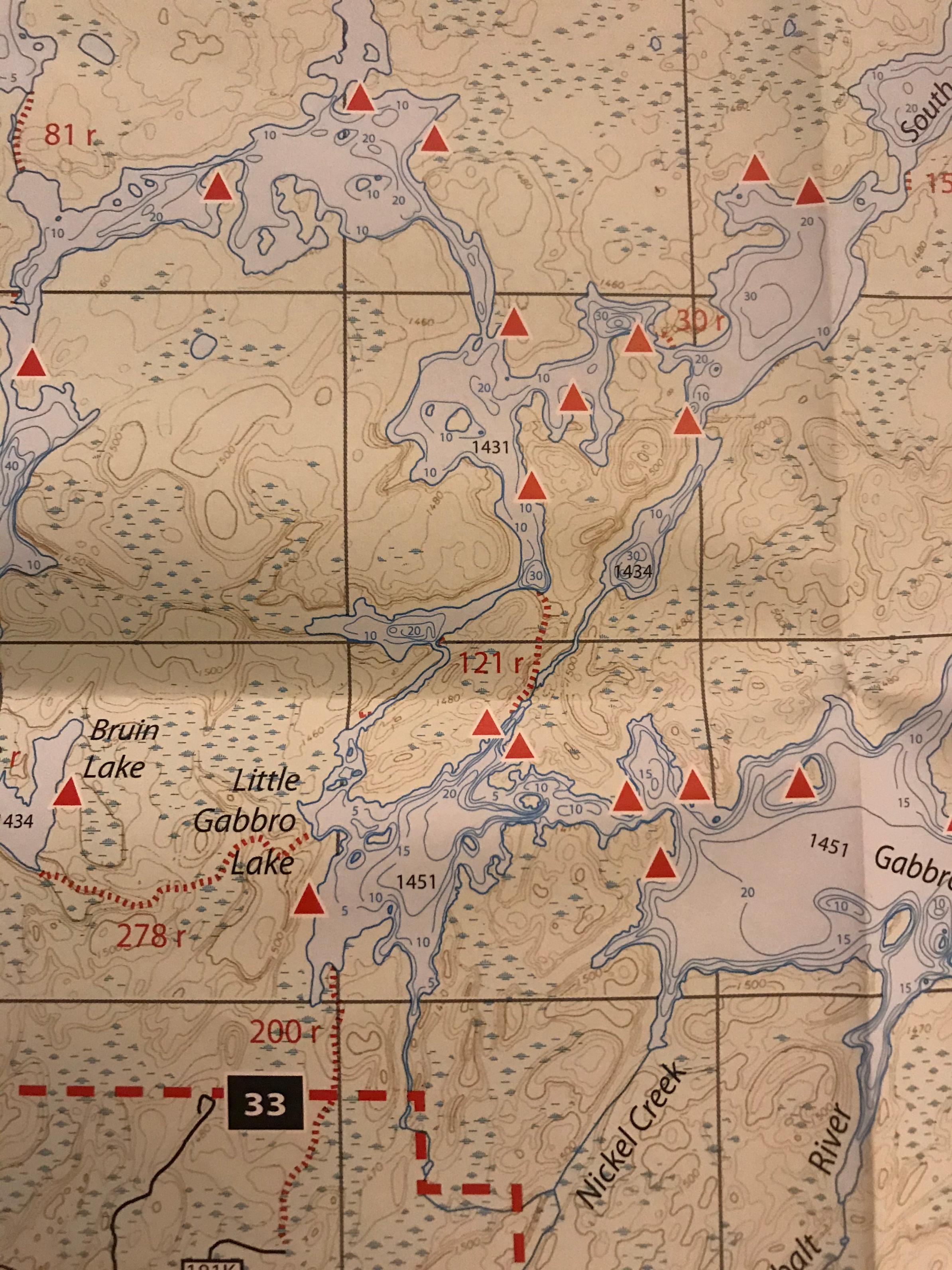
Lake elevations on Voyager map
|
|
3Ball
|
I have tried to find a way through that section. I think that the only way is to go from west to east through the other portage.
|
|
Minnesotian
|
OldGreyGoose,
Now I am curious as well. Did they say which side? Or both channels are dangerous? For contrast, here is a snippit showing the same area from my Voyageur map #7.
|
|
OldGreyGoose
|
Minnesotian: "
OldGreyGoose,
Now I am curious as well. Did they say which side? Or both channels are dangerous? For contrast, here is a snippit showing the same area from my Voyageur map #7.
"
Both sides are marked with the same message.
Does your map indicate the flow direction?
|
|
billconner
|
The portage is a very easy one.
I did "float" over damn 2 one fall at the urging of my trip mate. Probably won't do that again. Floated most of the way to short portage at end. No way of going upstream to Little Gabbro imho.
|
|
OldGreyGoose
|
cowdoc: "Lake elevations on Voyager map"
Yes, should have checked that first, lol.
L. Gabbro is 20' higher so the flowage is South to North in that area.
|