|
04/07/2021 05:36PM |
The only lake I saw going to Ely was Robinson by the highway. It was pretty dark. It won’t take long for it to come out. Had to get home and back to grandkids."
Robinson is open as of today. At least it looks like it on the MNDOT webcam.
|
04/07/2021 05:45PM |
marsonite: "
The only lake I saw going to Ely was Robinson by the highway. It was pretty dark. It won’t take long for it to come out. Had to get home and back to grandkids."
Robinson is open as of today. At least it looks like it on the MNDOT webcam."
Thank you rain! That’s amazing!
|
04/07/2021 08:11PM |
|
02/20/2021 07:08AM |
WhiteWolf: "My place 22 SM WNW of Des Moines
2nd coldest I've ever seen. here, Being it's Feb 16th, this one takes the cake..
"
Woodstove still going?
|
03/11/2021 10:19AM |
|
02/15/2021 08:16AM |
|
02/11/2021 07:22PM |
Luckily my put in is late May and it should be a pretty safe bet. Probably keep the bugs down with a late spring.
|
03/11/2021 10:32AM |
Basspro69: "I’m confident that most really long range forecasts can be taken with a grain of salt. I think weather forecasters do a really good job of forecasting within a weeks time. But as with this prediction the Late ice out prediction isn’t looking too good right now."
I think there is a 70% chance that there will be a least a 5 inch snow storm passing through Minnesota between March 7 and March 14 in 2022. I think that is a pretty safe prediction. :-)
|
03/11/2021 10:45AM |
sns: "So how much snow did the BWCA get in the storm yesterday/last night?"
Co-op observers for the NWS report between 8 inches at Snowbank Lake to 11 inches at Seagull Lake. Tuscarora Outfitters reported here this morning that 10+ inches fell on the upper Gunflint Trail.
|
03/09/2021 04:30AM |
Thanks for reading. And- Enjoy the weather- it's the only weather you got.
URGENT - WINTER WEATHER MESSAGE
National Weather Service Duluth MN
404 AM CST Tue Mar 9 2021
...QUICK-HITTING WINTER STORM WEDNESDAY NIGHT...
.An area of low pressure will lift northeastward through the
Upper Midwest Wednesday and Wednesday night. Precipitation should
start as rain during the day Wednesday and then change to snow and
freezing rain as temperatures fall Wednesday evening through mid-
morning Thursday. Precipitation should eventually change to all
snow everywhere before ending. There is a potential for a band of
heavy snow to affect portions of northern Minnesota and for
significant ice accumulation for portions of northern Wisconsin.
The snow and ice accumulation is expected Wednesday evening
through early Thursday morning with precipitation ending by mid-
morning Thursday.
The location of the band of heaviest snow is uncertain at this
time, however, we expect it to be located in the Minnesota portion
of the watch. With warm temperatures Wednesday into Wednesday
evening, the precipitation may fall mainly as rain and then change
to snow in northwest Wisconsin, which would result in lower ice
accumulation amounts than currently forecast.
MNZ012-019>021-026-035-037-092215-
/O.NEW.KDLH.WS.A.0003.210311T0000Z-210311T1500Z/
Northern Cook and Lake-Central St. Louis-Southern Lake-
Southern Cook-South Itasca-Northern Aitkin-
Carlton and South St. Louis-
Including the cities of Isabella, Hibbing, Two Harbors,
Silver Bay, Grand Marais, Grand Rapids, Hill City, and Duluth
404 AM CST Tue Mar 9 2021
...WINTER STORM WATCH IN EFFECT FROM WEDNESDAY EVENING THROUGH
THURSDAY MORNING...
* WHAT...Heavy snow possible. Snow accumulations of 4 to 6 inches,
with localized amounts to 8 inches possible.
* WHERE...Northern Cook and Lake, Central St. Louis, Southern
Lake, Southern Cook, South Itasca, Northern Aitkin and Carlton
and South St. Louis Counties. This includes the Tribal Lands
of the Bois Forte Band, Lake Vermillion area, the Fond du Lac
Band, the Grand Portage Reservation and the Mille Lacs Band,
Big Sandy Lake area.
* WHEN...From Wednesday evening through Thursday morning.
* IMPACTS...Plan on slippery road conditions. The hazardous
conditions could impact the morning commute.
PRECAUTIONARY/PREPAREDNESS ACTIONS...
Monitor the latest forecasts for updates on this situation.
&&
$$
|
03/09/2021 04:54AM |
|
04/04/2021 05:09PM |
|
04/06/2021 06:03PM |
|
03/27/2021 10:19PM |
|
02/15/2021 11:00AM |
|
02/11/2021 07:58PM |
Long range forecasters (talking months out) use various tools - many know about computer models etc. But exactly what drives these long range computer models (which btw - pretty much nailed a mild Dec/Jan- with a switch in Feb) ? Among many things- but perhaps the most important are teleconnections across the globe that "drive" the atmosphere. Thinking of them as football players- these would be the QB and your star DL or LB- that can win (or lose) a game on their own. TWO of the most important teleconnections as we enter late winter and into early Spring for the Nation East of the Rockies are the AO (Arctic Oscillation) and the NAO (North Atlantic Oscillation. (ESPECIALLY THE NAO the later in winter/spring you get E of the Rockies)
A big reason why it's turned cold is because of high pressure ( or weak low pressure) parked over Greenland. This forces-- or Blocks- Arctic air to drain S (especially if there has been a SSW - Sudden Stratospheric Warming event- which there has been back in early JAN but that is for another post) into the Lower 48. This oscillation is called the AO-

As shown- A -AO is more likely to produce cold in the Lower 48 compared to +AO. No wonder- here is the AO right now (and almost off the chart) and forecasted out-

Here is the link for those who would like to follow the AO forecast
The AO is probably more of a factor mid/late winter. But imo- not as important as the NAO- especially early Spring. The AO NAO are very similar but different- the AO is more for temps but the NAO is for storms all winter(especially E Coast) -- and TEMPS late seasn/Spring.
Some graphics on the NAO-


You can follow the NAO index and forecasts here.
In this case- ( current Arctic outbreak) -AO overwhelmed the field (think Tom Brady)--
In closing- negative phases of both the AO and NAO produce cold and storms E of the Rockies. + phases produce a zonal pattern and Pacific Air / mild temps and rather quiet weather. Anyone can look at computer models- but what drives the computer models? The above do. So - for those interested in long range weather- instead of following computer models which flip flop (because of others things too technical for this post) back and forth- focus on those index's links I posted of the AO and NAO and see how they do the rest of winter and into Spring. Thanks for reading and remember to enjoy the weather; it's the only weather you got.
|
02/12/2021 04:24AM |
Just trying to show the common public some behind the scenes info. Still a 30% chance imo of a normal ice out to early ice out. Those indexes WILL be the main driving force one way or the other. Why do I think they will be negative and lead to my thoughts? First part of winter and current ocean temps (compared to back in NOV) in the Central Pacific/ E Coast. And that severe winters of the past 10 years have been back loaded and go into Spring--- ie-- Ocean temps take a lot to change over 10 years.
|
02/12/2021 08:00AM |
|
02/12/2021 12:10AM |
|
04/08/2021 01:39PM |
|
04/08/2021 07:43PM |
Call it wisdom.
I’m a weather nerd and at 53 I’ve been lied to, cheated on, and let down far too many times to listen to it any longer. I don’t even bother getting a forecast before a trip. What’s the point. I heard there is a 50% chance of good weather this week!
I think many older people feel the same way.
Tom
|
03/12/2021 07:43AM |
|
03/11/2021 09:50PM |
|
03/11/2021 09:37PM |
|
03/11/2021 09:45PM |
okinaw55: "Drove around a bit to various sized lakes here in So. MN. I was surprised to see we're a bit away yet to ice out down here. Deep grey , at least for us colorblind folks but shores haven't let loose yet. "
Sakatah Lake in Waterville has a couple big open spots today...complete with bluebills and Mergansers....my bet is Lakes will start to open here in the next 10 days.
|
03/11/2021 11:11PM |
Sakatah Lake near Waterville in LeSeuer Co
Big open spot complete with Common Mergansers, Bluebills and Hooded Mergansers

|
03/01/2021 07:18AM |
|
03/01/2021 07:26AM |
|
03/01/2021 10:03AM |
sns: "ice thickness is about 60% of normal-early ice out coming upJimmyJustice: "Nobody jumped at May 13 over/under. What say you now?"
I will throw caution to the wind and take the under."
|
02/11/2021 03:55AM |
|
02/11/2021 09:03AM |
WhiteWolf: "The winter thus far has been mild. Until the last week or so. Expect this trend to continue. Mild winters up front have little or no effect on ice out. Reading into this = late ice out. More details to come. Personally if i had a pre May 15 entry on big Lakes- I would be mildly concerned at this juncture-- and this HAS very little to do with recent and progged cold. (At least the long forecast most get) This is looking like 14' 08' , 1996' ish... for ice out. Too early to say- maybe- but the cards are laying down for a late ice out comparable to norms... Quite confident in that. I will post some maps if I get time at work later today -"
1995-96 winter was bitter cold and lot of snow. This year most of the state has much below normal snow on the ground and until this week ice depth on lakes was like 20 inches below normal. Maybe ice depth will catch up some now.
Yes 95-96 lakes had ice for opener in much of the state.
No snow on ground often means it warms up faster. Recent years it seems we have had late start to winter than spring lags a little.
|
02/11/2021 07:15PM |
Bemidji is forecasted for -31F tonight.
|
02/12/2021 01:41PM |
A coin toss I can handle... :-)
|
02/12/2021 01:25PM |
|
02/12/2021 02:30PM |
Savage Voyageur: "The funny thing about weather predictions is they NEVER say they were wrong after the weather date. They give you the 15 day prediction then you are supposed to take it as gospel truth. I’ll be using BassPros lucky quarter. "
Actually meteorologists do not speak in gospel truths but in probabilities. 70% in WW case for a late ice out based on a 60-90 day forecast. That probability could change in 30 days. However, I would bet against WW on this one, especially if he gave me odds since 70% puts the odds in his favor.
|
02/12/2021 03:28PM |
hobbydog: "Actually meteorologists do not speak in gospel truths but in probabilities. 70% in WW case for a late ice out based on a 60-90 day forecast. That probability could change in 30 days. However, I would bet against WW on this one, especially if he gave me odds since 70% puts the odds in his favor. "
This. A 70% chance of late ice-out still leaves 30% on the table. That's far from nothing, and no scientist or anyone with any scientific literacy would ignore 30%.
|
02/12/2021 05:30PM |
|
02/12/2021 03:59PM |
Is it safe to say that the AO affects the location of the jet stream and the AO is effected by a positive or negative NAO?
"It is important for people to realize that winds in the northern hemisphere travel counter clockwise with low pressure systems and in a clockwise direction with high pressure systems."
This youtube was helpful in explaining the AO and NAO for me.
|
02/12/2021 04:17PM |
|
02/12/2021 06:45PM |
arctic: "Seems like the onset of winter has been delayed in recent years, but it lingers later into the spring."
agree
|
02/12/2021 08:43PM |
I would say "yes" to the AO affecting the location of the jet stream- but only if strongly + or strongly -. An AO less than 3 on those charts probably is not strong enough one way or the other. As far as the NAO affecting the AO- that's a gray area. If it did, more so to happen the Spring when the NAO has bigger influence because the Atlantic is at it's coolest temps relative to being warmer in the early Winter.
|
02/12/2021 09:23PM |
Pinetree: "arctic: "Seems like the onset of winter has been delayed in recent years, but it lingers later into the spring."
agree"
For sure. The last good DEC down here was 2013 and 2009. Have had some memorable FEb's though lately.
|
02/12/2021 08:54PM |
HighnDry: "What's the moisture outlook for the Feb-May period? Last year up on Crane Lake the outfitters were bemoaning the 2 to 4 feet below-normal water levels. Curious of snow falls will pick up and later on, rain fail?"
First off, and I will be frank- forecasting moisture long range is MUCH more difficult that temps, or , at least that has been my experience. Air masses involve 1000's of SQ miles, several winter storms in 10 day period - the S Side of the Twin Cities (example only) can get 2" while 30 miles N can get 2'. Same is true with rain systems / thunderstorms.
Here are some outlooks- the first I would be leery of because it's nearly a month old-
This one is for March and the last 9 days worth of runs. The "drying" in NE MN - N WI on FEB 12th run- I wouldn't be concerned off, yet, unless it's a trend. I will keep you posted if it continues , but for now, March looks wetter than the past several months and it should as some of the bigger snowfalls in the Northland (non lake effect) occur March/April time frame.

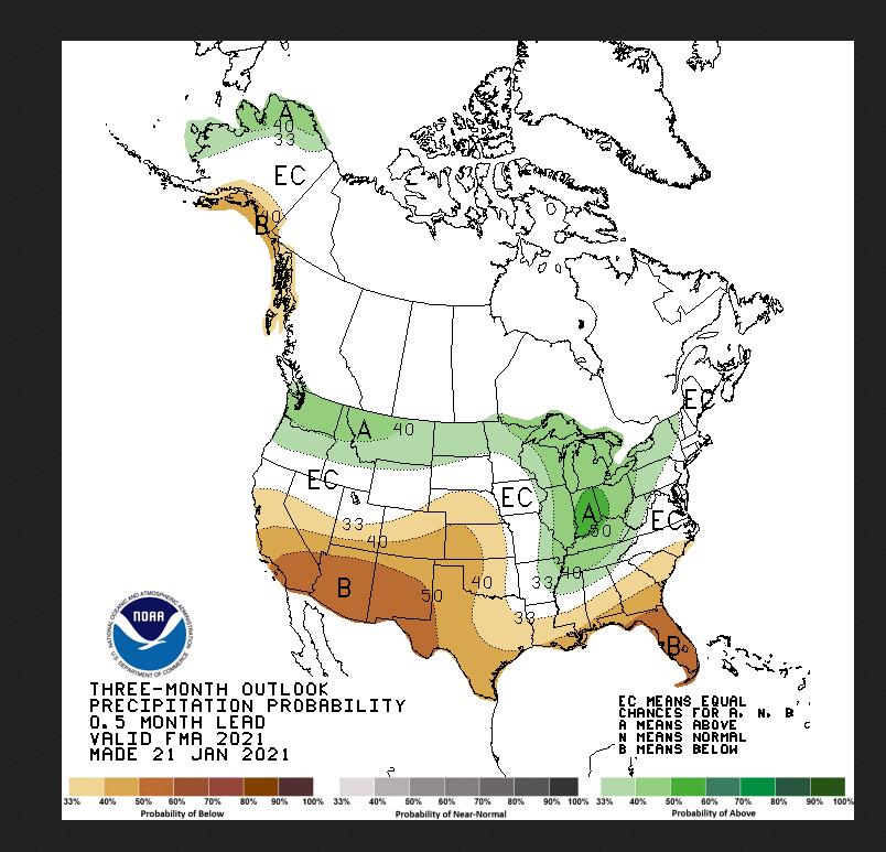
here is the current outlook for precip for March/April/May- again , don't put a lot of stock in these but it's something to follow daily if you want I will provide the link.

|
02/13/2021 07:42AM |
Originally it’s was just a few days to a week...Pushing 2 weeks now and the forecasts all seem to be very wrong. A week ago today was going to be 10*. The forecasts keep pushing it back and back.
We’ve had to cancel/ push back two weekends up N in a row and am hoping not to have to cancel next weekend as well but every day it seems they keep shifting the forecast more to the negative.
What are your thoughts?
|
02/13/2021 08:15AM |
|
02/21/2021 04:39AM |
airmorse: "WhiteWolf: "My place 22 SM WNW of Des Moines
2nd coldest I've ever seen. here, Being it's Feb 16th, this one takes the cake..
Woodstove still going?"
Yep-- both were cranked.
Next weekend looks interesting. Again- keep your eye on that AO index I posted.
|
02/21/2021 10:41AM |
|
02/21/2021 11:00AM |
airmorse: "Are the forecasting models taking into account all the snow on the ground? I just came back from Texas and there is snow OTG all the way down to Austin. Amazing!!!"
Actually much of Minnesota snow depth is like 30-40% of normal now. A few warm days it would be gone. Ice on Brainerd lakes is like 55% of normal. This could lead to a early spring up here.
|
02/21/2021 01:24PM |
airmorse: "Are the forecasting models taking into account all the snow on the ground? I just came back from Texas and there is snow OTG all the way down to Austin. Amazing!!!"
Yeah they "try" to do so now. Back 25 years or so ago- not so much. Most times nowdays - models overdo the effects of snow on the ground leading to temps forecasted too cold. However, this bias usually occurs with clear nights / sunny days. Throw clouds into the mix and most models can't handle fresh snow as they can't "see it".
Des Moines and Omaha reporting nearly 50-55" of snow thus far this snowfall season. The map is only through y-day and OMA just got 8" and DSM around 3-4". Both are on pace for snowiest seasons ever recorded (DSM is 72" in 1911-12) My concern for the Northland is that this storm track moves N - like they eventually all do in the Spring and gets more strength as the seasonal jet stream shifts N and brings precip with it. That's alot of snow per normals as they head now (the pattern). One caveat- is will it be cold enough for all snow for most of these events heading into mid- March? For most parts of MN- yes. S.MN may mix at times. Cold air behind will be Arctic in nature but fleeting. These "warm" ups will be precursors to the next waves of energy. "warm air" this time of year is breeding area for precip. (in most cases- more snow) Going out on a limb here, I know most of MN has not seen fair share of snowfall compared to avg's. I'd expect 50% of your seasonal snowfall is still to come-- so expect a very snowy march and April- and even into May in the Northland.
SNowfall through the 20th. To see DSM ahead of I-Falls and near even DLH is amazing. Expect a BIG change in coming weeks.

|
02/21/2021 05:48PM |
|
02/22/2021 12:20PM |
|
02/26/2021 06:34AM |
|
03/01/2021 10:02AM |
JimmyJustice: "Nobody jumped at May 13 over/under. What say you now?"
I will throw caution to the wind and take the under.
|
03/01/2021 04:55PM |
|
03/01/2021 03:05PM |
WhiteWolf: “Going out on a limb here, I know most of MN has not seen fair share of snowfall compared to avg's. I'd expect 50% of your seasonal snowfall is still to come-- so expect a very snowy march and April- and even into May in the Northland.
SNowfall through the 20th. To see DSM ahead of I-Falls and near even DLH is amazing. Expect a BIG change in coming weeks.
Music to my ears. Overnight low at our house in Duluth was 2 °F. If we get that 50% this “spring,” I’ll be happy to continue skiing. :-)
|
03/02/2021 07:01AM |
|
03/02/2021 07:44AM |
I still think ice out will be real early, but than it can be miserable.
49 degrees F. at 4 PM today
|
03/02/2021 04:52AM |
Don't trust it. ( coming warm up lasting) It's early March. Record lows will surprise you come March 20th or so. (Not calling this, just the potential is there) Winter is FAR from over for the Northland-- as is normal. Again- watch those AO and NAO values!!!! They are KING when it comes late winter/ early Spring!!!! There is still too much cold air available not far away. Yes- solar is increasing as is day length- but this is not 2012. (too be fair- it's also not 2013-14) Could I be wrong? Certainly. But only been doing this long range stuff since 1999 so I got a gut hunch. One way or the other- Mid March looks very active with precip- rain or snow- but the cold air (below normal) is not far away. How far it shifts S and SE ( W CAN AND NW USA LOOKS COLD-- quite confident ) still remains a huge issue.
One thing that is certain - the next 10 days is going to melt serious snow and ice.
Again - I could be totally wrong on the late ice. But just giving you all my thoughts based on experience (20+ years) . But - and I focus on this on all time- dealing with nearly infinite amount of variables in the atmosphere - I know nothing. Just looking at trends and past years that seem to reflect this current pattern and where it might lead in 3-4+ weeks.
Enjoy the weather- it's the only weather you got.
|
03/09/2021 07:55AM |
"60 percent of the time, it works every time" - Ron Burgundy
Love the charts and "data" to back up the 70% confidence level of late ice out... what does that even mean?
|
03/09/2021 11:29AM |
My snowblower didn't really get warmed up this year.
|
03/09/2021 03:58PM |
bobbernumber3: "This thread has the substance of the old movie quote,
"60 percent of the time, it works every time" - Ron Burgundy
Love the charts and "data" to back up the 70% confidence level of late ice out... what does that even mean?
"
This is a fair question. If I find time later I will lay out some in-depth details, but basically all long range forecast are based on % chance of being above normal / normal or below normal and assigning a confidence level to that in either low,medium or high. Your really good forecasters will tell you by how much above or below.
While we're on the topic, most don't understand the NWS use of % chance of precip in their grid forecasts.
For example the current forecast for Hibbing for Wed night / Thursday Am is "90% chance of snow. Snowfall accumulation of 3-5" possible". Now wouldn't any accumulation mean 100% chance of snow?
It's based on a grid system - in this case likely around 16-25 sq miles and forecaster believes that 90% of that grid will receive 3-5" of snow.
|
03/09/2021 04:19PM |
|
03/09/2021 05:13PM |
Once the snow is gone off surface of lakes, than sunlight is absorbed into ice and the process really begins.
Hopefully I'll have some time later to post some #'s on snowfall and temps for the winter. I know DLH was near normal for snowfall but a large chunk of that fell nearly a half year ago in Oct into NOV, like 32" if memory serves me anymore.
|
03/09/2021 06:16PM |
|
03/09/2021 10:11PM |
The opening post was meant for BWCAW lakes but could be applied anywhere I guess. I would likely be wrong then on lakes in S.MN- but right now sticking by op thread for BW lakes. Small ponds just opened up here today near DSM.
Pressing for time, but I will try and answer the question about how long range forecasts are made more in-depth. What's basically used is the teleconnections across the globe along with ocean temps. Then analog years (years that have similar ocean temps etc to the current year) are studied more in-depth, but no two years are really even remotely the same so they a weighted -- Usually a group of 5-6 years. Some - as mentioned- are weighted more and than a "blend" is made of how the temps avg in those years. SO - in my forecast- 70% of years when gone through the above process showed ice out on or later than avg. 30% were on or earlier than avg. This was done by taking the avg temp for March/APril and MAY (until the avg ice out) and comparing it to the blend and comparing to avg temps for avg ice out for say April 29th (up until April 29th) for Shagawa in Ely. I hope this helps.
For my forecast nearly a month ago- snowfall is not factored. Just assuming it avg's out. Avg temp location used was Ely,MN.
|
03/09/2021 09:56PM |
WhiteWolf: "Sunshine alot!!
Once the snow is gone off surface of lakes, than sunlight is absorbed into ice and the process really begins.
Hopefully I'll have some time later to post some #'s on snowfall and temps for the winter. I know DLH was near normal for snowfall but a large chunk of that fell nearly a half year ago in Oct into NOV, like 32" if memory serves me anymore."
okinaw55: "Based on temps and ice conditions down in southern mn I'm leaning toward an early ice out but the models you mentioned might be the science that proves me wrong. Fields are mostly black again which I know contributes to warmer weather. We're just starting March so I expect some major snowfalls in the next month+ but that sun is beating down anything we have gotten recently. "
And so .. earlier now you think? Ponds are open down here lakes are dark dark. Should go any day now down here in S. MN.
|
03/10/2021 12:17AM |
|
03/12/2021 11:09AM |
As for ice in the Twin Cities, I'm hoping to walk onto a lake for my probably-final ice fishing session of the season. I think it'll still be walkable as long as I can find a solid spot to get on from shore (the only part I'm concerned about). Last weekend the lake I was on had 16-18 inches of ice, with at least 12 of that being pretty good. Even with the warm temps and rain, again as long as the shoreline is OK, I think walking out should be OK.
|
03/28/2021 02:00PM |
jdoutdoors: "I'm doing the Horse River up to LBF/Crooked this spring and really hoping for a bunch of precipitation to bring water levels up so the Horse won't be a slog. I cheer every time snow/rain is in the forecast!
As for ice in the Twin Cities, I'm hoping to walk onto a lake for my probably-final ice fishing session of the season. I think it'll still be walkable as long as I can find a solid spot to get on from shore (the only part I'm concerned about). Last weekend the lake I was on had 16-18 inches of ice, with at least 12 of that being pretty good. Even with the warm temps and rain, again as long as the shoreline is OK, I think walking out should be OK."
Were you able to find a lake to walk on after this post? I was trying to make one last trip around that time frame but couldn't find a lake nearby that I could get on. The main lake ice didn't concern me but I couldn't jump ten feet of open water to get onto it. Packed the ice gear up and moved my attention to the river. Just waiting for the water temp to warm up a bit. On my first trip the water was still ice cold but it's always fun to cast the long rod the first time for the season.
|
03/28/2021 03:03PM |
nofish: "jdoutdoors: "I'm doing the Horse River up to LBF/Crooked this spring and really hoping for a bunch of precipitation to bring water levels up so the Horse won't be a slog. I cheer every time snow/rain is in the forecast!
As for ice in the Twin Cities, I'm hoping to walk onto a lake for my probably-final ice fishing session of the season. I think it'll still be walkable as long as I can find a solid spot to get on from shore (the only part I'm concerned about). Last weekend the lake I was on had 16-18 inches of ice, with at least 12 of that being pretty good. Even with the warm temps and rain, again as long as the shoreline is OK, I think walking out should be OK."
Were you able to find a lake to walk on after this post? I was trying to make one last trip around that time frame but couldn't find a lake nearby that I could get on. The main lake ice didn't concern me but I couldn't jump ten feet of open water to get onto it. Packed the ice gear up and moved my attention to the river. Just waiting for the water temp to warm up a bit. On my first trip the water was still ice cold but it's always fun to cast the long rod the first time for the season."
I did actually get out that weekend, had a couple inches of open water at the shore and some very thin looking ice for about a foot, but was able to just long step it onto some decent ice, and once I got onto the main lake there was still 6 inches of honeycomb and 6 inches of decent ice. Getting off the lake about 6 hours later on that sunny warm day yielded almost a foot of open water at the shore but again just a long step/short jump made it no problem (especially having waterproof boots on).
Didn't catch anything too impressive, but had a decent little last day on the ice with a couple 10-11" crappies and 8-9" gills.
|
04/04/2021 05:40PM |
I have worked with meteorologists my whole career in wildland firefighting and hold them in high regards, this goes for WW as well. I give him 2 thumbs up for sticking his neck out there and I am curious if he would venture to share with us as to why his 70% prediction appears that it will not come to fruition.
MN Ice out map
|
04/04/2021 05:59PM |
bobbernumber3: "So where are we at on this prediction?"
We’re out three weeks early 100 miles west of Ely. I’m going there tomorrow to grab some boats... I’ll check it out!
|
04/04/2021 07:24PM |
LindenTree: "I think this map can answer your question.
I have worked with meteorologists my whole career in wildland firefighting and hold them in high regards, this goes for WW as well. I give him 2 thumbs up for sticking his neck out there and I am curious if he would venture to share with us as to why his 70% prediction appears that it will not come to fruition.
MN Ice out map "
I agree, Linden. Even though it looks like his 70% prediction is not going to happen, I still have a lot of respect for him on putting it out there for all of us to criticize. I also would be curious as what factors happened to cause his prediction to change.
|
04/04/2021 07:55PM |
|
04/05/2021 06:41PM |
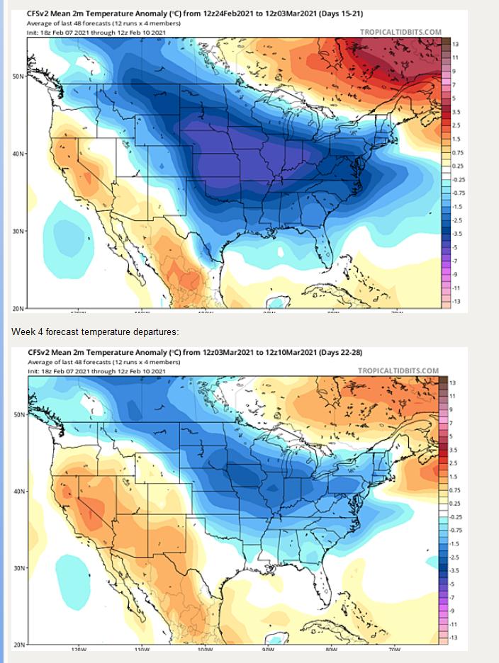
#1- I expected a late spring based on work I did late last fall and the ending the of the Hurricane Season 2020. Though that didn't work out- late season ending of the Hurricane Season is ALWAYS a good indicator of the front half of winter, which it was- (mild) I just took it too far based on other assumptions.( long story) I also (10%) took into factor the rather late Springs of the past 5-10 years and really banked on 2012 not repeating itself and more like 2013' 14' and roughed the avg out. ( they amonsgts others were 10 of the years I factored in) It turned out more like 2012, though obviously not to those extremes but it cost me 10% if not more even with a warm start to the winter. Below normal Snowfall also cost me. 5%. especially late season.
#2- As stated previously in this post-- keep an eye on the AO and NAO oscillations. They are ( and will always be crucial) to temp/precip for the Northland, esp Late Winter. ( not in the summer though if your wondering) I expected them to go negative, not as much as FEB, but something as a compromise to previous in the winter and factored that in with -- It didn't happen AS MUCH as I thought - but it did - too late,(which is common in my field) but not in the area I thought. I had the pattern ,, just too late and too far E. . So- maybe not winter like, but mid APRIL into MAY may be what I thought- just a month too late compared to avg's and too late for a late spring / late ice out. maybe a cool late April/ early MAy? But at this point- I write that off as the warmth is likely to strong.
#3- Areas just E- Great Lakes and NE USA did see rather cool air / below normal just recently. I thought this area would be 500 miles further W and NW and more robust and earlier. The NAO and AO were there- just not as strong as thus not as far back W and N.
#4- Ocean temps in the PAC. Ocean temps in the PAC and nearly worldwide have gone nearly equal and the Oceans temp worldwide are close to being as equal to avg as they have been in a long time. I did not see the cooling in the PAC to be as strong which drives ( talking BIG here, not small ) basically warm air into the interior of major land masses.(short term) This rather = of global ocean temps has driven ALL LONG RANGE forecasts uncanny as no one saw the global oceans coming this close to = just 3 months ago. But this cooling of overall ocean temps does not bode well for C.USA temps and overall precip.... SEE ending.
In my defense- the cold air that I forecasted and BUSTED ON- was there, it just happened to be in Europe this time around. ( which means "torch" for us reading this with current pattern) Some may say it's a flip of a coin, - but I screwed up. -- (your right THIS time) Honestly can't tell you the one reason why, but basically everything snowballs when you get one piece of 1000000 piece puzzle wrong. The above is all I got. But I gave reasons why i was (thought) wrong. And will study for the next season,------ and if your still reading --- warm/DRY SUMMER is expected. Drought conditions will continue if not expand for many reading. Much like 2012 (the month I missed MARCH is huge )- and near the heat of 2012. (though I don't think quite to 2012 levels) Just my .02-- I try -- (and Iam wrong at times) trying to give the why before the what when anyone can monday morning QB. Enjoy the weather- it's the only weather you got.... I was wrong this time....... but I will be back better having learned from my mistakes!!!!
|
04/05/2021 07:10PM |
|
04/06/2021 02:23AM |
I personally learned a ton from this thread. Thank you WW!
To quote “the weatherman”: “Its wind. it’s wind...it blows all over the place!”
|
04/06/2021 09:57AM |
The only lake I saw going to Ely was Robinson by the highway. It was pretty dark. It won’t take long for it to come out. Had to get home and back to grandkids.
|
04/06/2021 01:14PM |
Hard to tell for sure, but it looks like there may also be some open bays on Vermillion itself.
|
04/08/2021 08:14PM |
I have to confess; I have recently used/shared this phrase (I love it). Especially when the weather is unfavorable.
You simply can't argue with it.
JW
|
04/09/2021 08:05AM |
tumblehome: "I have stopped reading/listening/watching weather forecasts.
Call it wisdom.
I’m a weather nerd and at 53 I’ve been lied to, cheated on, and let down far too many times to listen to it any longer. I don’t even bother getting a forecast before a trip. What’s the point. I heard there is a 50% chance of good weather this week!
I think many older people feel the same way.
Tom"
What if every forecaster was saying there was a chance for severe weather for when you want to go out?
|
04/10/2021 02:22PM |
Tom
|
04/10/2021 02:15PM |
84% sure it will be out by May 13

|
04/10/2021 02:24PM |
bobbernumber3: "50% sure the ice will be out on Saganaga by May 2
84% sure it will be out by May 13
99.99% sure ice will be out by May 2 on Sag
100% by May 13.
My guess is that Fenske will go tomorrow or Monday.
|
04/11/2021 01:22AM |

I did the same thing for ice out that NOAA does for long range outlooks. But I also factored in many other variables , but used their same scale for the 90 days starting FEB 1st. If you got an issue with it- take it up with them-- not me. How much below or above avg? 51% above normal could be .1F or 10F. 49% below normal could have the same range-- No??? ask NOAA. At least I had dates in mind for ice out (Ely area around April 28th) - which I busted on and admitted my errors and WHY. (at least to my thinking).
Been thinking for years of starting a "WEATHER DISCUSSION" group/thread on here - similar to other not so read groups such as "campsites" or "photography"-- "BeaV's Alaska adventure" that is not in General Discussion and that those only interested in "Weather Discussion" could join. That would likely be ideal and I would be willing to lead this group. But a mod would have to contact me if interest is high enough. I have no clue how to form such a group. A simple question and answer segment would be a great way to start.
Enjoy the weather- it's the only weather you got.
|
04/10/2021 06:59PM |
Banksiana: "bobbernumber3: "50% sure the ice will be out on Saganaga by May 2
84% sure it will be out by May 13
99.99% sure ice will be out by May 2 on Sag
100% by May 13.
My guess is that Fenske will go tomorrow or Monday."
You're not a statistics/data guy either, I see.
|
04/29/2021 07:46PM |
Median ice out date 5/6. (1950 - present)
Median ice out date 5/2. (1998 - 2020)
Graph makes it look pretty average.

|
02/20/2021 09:11AM |
|
04/10/2021 01:21PM |
|
02/11/2021 09:09AM |
|
02/13/2021 04:41PM |
Grizzlyman: "WW. -40 in cook right now. How long in your opinion will this arctic air hang around?
Originally it’s was just a few days to a week...Pushing 2 weeks now and the forecasts all seem to be very wrong. A week ago today was going to be 10*. The forecasts keep pushing it back and back.
We’ve had to cancel/ push back two weekends up N in a row and am hoping not to have to cancel next weekend as well but every day it seems they keep shifting the forecast more to the negative.
What are your thoughts?"
You are correct on the pushback/extension of the outbreak. This was caused by AO being off the charts -,( and not read well by deterministic models) and the intense blocking over Greenland forced the Polar Vortex to just hang out and not progress back to where it belongs. But that will change later this week. Two storms systems will ride up from the South to the E.Coast- the later one on Thursday into Friday will wrap more typical Mid-FEB cold temps (still cold and below 0, but not this -40F stuff) from Central Canada - the residual effects of the PV. But the day highs will be more normal like- especially by Sunday. All in all, next weekend looks pretty good - just below normal at night. (this is for N.Mn)
Some potential positive news today for a warm March (even late FEB) - or at least the start. Several signs across the globe that are showing a zonal flow from W to E across the Lower 48 and flooding most of the Nation with Pacific air. This is shown in the European Weeklies long range forecast shown here-
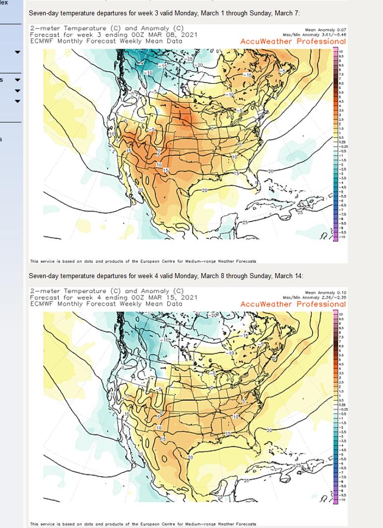
There is two caveats however. European Weeklies are usually about as accurate as can be at this range, but this year they have struggled a tad. Then there is the American version for basically the same time period.
The reason for the stark differences is how the models are handling a telelconnection in the Indian / Pacific oceans in the tropics called the MJO- or Madden /Jullian Oscillation - I won't get into it her, but it's huge when other teleconnections don't over ride it like the recent tanking of the AO did. My experience and gut tell me to blend the two together- but give more credence to the European Weeklies (2-3 times) and the American (1)-- blend that out you get warmer than normal but not as warm as the Euro is showing. If the Euro completely wins out my 70/30 forecast for late ice out etc is not looking so hot....
Thanks for reading.
|
02/14/2021 10:08AM |
|
02/13/2021 11:13PM |
|
02/14/2021 03:46AM |
mschi772: "]hobbydog: "Actually meteorologists do not speak in gospel truths but in probabilities. 70% in WW case for a late ice out based on a 60-90 day forecast. That probability could change in 30 days. However, I would bet against WW on this one, especially if he gave me odds since 70% puts the odds in his favor. "
This. A 70% chance of late ice-out still leaves 30% on the table. That's far from nothing, and no scientist or anyone with any scientific literacy would ignore 30%."
Very True, and why I laid the cards I did. Even with a slight take back away y-day from my 70% deal-- I really feel the late March/April time frame will be sub-par for early ice out. This is based on experience and gut feelings. Those same things have gotten me into more trouble in other aspects of life rather than weather progs!! Enjoy the weather- it's the only weather you got. It's going to be very interesting come late March/ early April in how the connections across the globe set up. And I will be first to admit IF iam wrong. One must admit that in a field with near infinite possibilities.
|
02/14/2021 06:36AM |
|
02/14/2021 11:12AM |
|
02/14/2021 11:20PM |
|
02/16/2021 07:07AM |
2nd coldest I've ever seen. here, Being it's Feb 16th, this one takes the cake..
|
02/20/2021 07:04AM |
|
02/22/2021 01:25PM |
Pinetree: "Measured 9 inches of snow on the ground at Longville today. Brainrd has 9 inches also. That is getting close to some record low snow cover there for now. Actually spring can change things but were getting close to a drought with last summer being dry. "
Downstream of you, the Mississippi here in the Twin Cities is as low as I can remember seeing it in a long time. We're riding fat bikes on beaches many of us have never seen. On one hand it's a nice break from the constant high water events, but I know it's far from normal. Most of my walleye spots are dry ground right now.
According to NWS the river downtown St. Paul is at 3.41 feet. Flood stage is considered 14 ft here. Our recent crests:
(1) 20.19 ft on 03/31/2019
(2) 13.66 ft on 07/01/2018
(3) 14.38 ft on 05/01/2018
(4) 10.59 ft on 05/29/2017
(5) 9.96 ft on 09/30/2016
(6) 7.55 ft on 05/29/2015
(7) 20.13 ft on 06/26/2014
(8) 14.05 ft on 07/01/2013
(9) 13.09 ft on 06/03/2012
(10) 18.71 ft on 04/10/2011
|
02/26/2021 09:23AM |
We have 40 degrees F. and wind gusts right now of 40MPH.
|
03/02/2021 06:55PM |
Amounts were impressive. A band of one to two feet of snow fell from Itasca State Park to Babbitt. The heaviest three-day total reported was 32 inches, 5 miles north of Virginia by an unofficial National Weather Service Cooperative Observer. Dixon lake in Itasca County was not far behund with 29 inches. Along with the snow, some needed moisture fell over Wadena and Otter Tail Counties, as well as other parts of northern Minnesota.
2008
|
03/03/2021 05:28PM |
|
03/03/2021 06:53PM |
Zulu: "Accuweather just came out with a Spring forecast and it echoed what WW said a week ago. Midwest will be very cold for a few months beginning around the 20th. Darn it."
Actually in the Brainerd neck of the woods we need a lot of precip-so a snowstorm is Okay. Lot of maple syrup people out today.
|
03/07/2021 10:22PM |
|
03/07/2021 11:02PM |
Basspro69: "My lucky quarter says normal ice out "
snow is off the lakes and fields are almost free of snow. We have 20 inches of ice instead of normal around 32 inches. Were already a foot ahead of normal and maybe 60 degrees F,. this week in Brainerd. We got close to 35-40 days plus to melt to be normal.
|
03/10/2021 02:29PM |
|
03/12/2021 10:58PM |
jdoutdoors: "I'm doing the Horse River up to LBF/Crooked this spring and really hoping for a bunch of precipitation to bring water levels up so the Horse won't be a slog. I cheer every time snow/rain is in the forecast!
As for ice in the Twin Cities, I'm hoping to walk onto a lake for my probably-final ice fishing session of the season. I think it'll still be walkable as long as I can find a solid spot to get on from shore (the only part I'm concerned about). Last weekend the lake I was on had 16-18 inches of ice, with at least 12 of that being pretty good. Even with the warm temps and rain, again as long as the shoreline is OK, I think walking out should be OK."
You got more guts than me. Once it honeycombs and turns dark, I sit on shore and watch.
|
04/11/2021 01:22AM |
Savage Voyageur: "The funny thing about weather predictions is they NEVER say they were wrong after the weather date. They give you the 15 day prediction then you are supposed to take it as gospel truth. I’ll be using BassPros lucky quarter. "
I think I proved this otherwise. But your right for many in the field. The majority of the bad ones ( or that have no clue) ruin it for the minority of the good guys/gals that actually care and go back (after admitting error and why) and learn from mistakes. I think that's why I get heat on here ( anywhere- you can't please everyone) - as those that have followed me over the years have seen the results - and I bat over .400 easy past 30 days. But when a man is wrong- the haters jump like a flies on dung. The main issue with this is computer models and the junk you get on your phones. ?? No need for Dif Calculus 3 and all the Physics you can take? Or no need for some common sense? That's the problem. People take weather forecasts from phone apps for 15 days + that are junk after 1 day. And most trust them. That's the scary thing. DO NOT TRUST YOUR PHONE APPS PAST 72 hours!!! And then blame it on whatever-- the weather guy!! Anything past 72 hours on a phone app- doesn't have the in-depth soundings one expects that one thinks they are getting. No human augmentation . Sadly this is true of many TV mets that let the computer do the talking past 72 hrs.
At least I give reason for the why before the what on here. And concede when I'am wrong and try to show the "why".
Enjoy the weather- it's the ONLY weather you got.
|
04/11/2021 09:49AM |
Banksiana: "bobbernumber3: "
You're not a statistics/data guy either, I see."
You consult charts.
I look at lakes."
+1. Direct observation is best! and more fun...
|
04/11/2021 08:36AM |
WhiteWolf: ".....At least I had dates in mind for ice out (Ely area around April 28th) - which I busted on and admitted my errors and WHY. (at least to my thinking)...
"
But you never posted this prediction, so it's not a bust!
|
04/11/2021 08:48AM |
bobbernumber3: "
You're not a statistics/data guy either, I see."
You consult charts.
I look at lakes.
|
04/11/2021 08:51AM |
Savage Voyageur: "The funny thing about weather predictions is they NEVER say they were wrong after the weather date. They give you the 15 day prediction then you are supposed to take it as gospel truth. I’ll be using BassPros lucky quarter. "
They are right enough that people pay attention. Also remember the forecast is a prediction.
Meteorologist are scientist. If you believe in science you will notice the meteorologist are right more often than the "blow comb" scientist on the national tv.
I appreciate WhiteWolf and his thoughts on the weather.
|
04/11/2021 09:28AM |
|
04/11/2021 11:37AM |
PineKnot: "So can I expect wind like last year from June thru Sep?? The wind seemed to howl 15-20 mph+ from the NW or SE two-thirds of the time....really made solo fishing a challenge...."
I've never had a trip like last years. It was mid June, 5 straight days of 15-20 mph wind. I think we had one calm morning. We usually get out very early to avoid crossing sag in heavy wind, and still faced double digit winds both directions. We were wind bound for two days. Just wasn't worth fighting the wind and waves. Kept the mosquitos away though, so I guess there's that.
It's already been a windy spring.
|
04/11/2021 04:27PM |
|
04/11/2021 04:39PM |
WhiteWolf: "Savage Voyageur: "The funny thing about weather predictions is they NEVER say they were wrong after the weather date. They give you the 15 day prediction then you are supposed to take it as gospel truth. I’ll be using BassPros lucky quarter. "
I think I proved this otherwise. But your right for many in the field. The majority of the bad ones ( or that have no clue) ruin it for the minority of the good guys/gals that actually care and go back (after admitting error and why) and learn from mistakes. I think that's why I get heat on here ( anywhere- you can't please everyone) - as those that have followed me over the years have seen the results - and I bat over .400 easy past 30 days. But when a man is wrong- the haters jump like a flies on dung. The main issue with this is computer models and the junk you get on your phones. ?? No need for Dif Calculus 3 and all the Physics you can take? Or no need for some common sense? That's the problem. People take weather forecasts from phone apps for 15 days + that are junk after 1 day. And most trust them. That's the scary thing. DO NOT TRUST YOUR PHONE APPS PAST 72 hours!!! And then blame it on whatever-- the weather guy!! Anything past 72 hours on a phone app- doesn't have the in-depth soundings one expects that one thinks they are getting. No human augmentation . Sadly this is true of many TV mets that let the computer do the talking past 72 hrs.
At least I give reason for the why before the what on here. And concede when I'am wrong and try to show the "why".
Enjoy the weather- it's the ONLY weather you got.
"
I actually find the 10 day forecasts on my phone to be quite accurate and valuable, certainly not junk. Sometimes to cold front forecasted 8 days out arrives a day early or a day. Temps may get adjust up or down a bit but the are directionally accurate. Most that complain about them don't understand how to read them in the context of the probability for a given period 5 or 10 days out. No meteorologist is 100 percent accurate 100 percent of the time......even 24 hours out. Neither are those generated by models' and sent to my phone.... I don't expect them to be.
|
04/12/2021 04:18PM |
|
04/19/2021 01:36PM |
|
04/19/2021 01:59PM |
Let this thread roll to the bottom of the list.
PLEASE!