|
05/20/2024 04:49AM |
|
05/20/2024 07:11AM |
Ultimately we went around into the bay and took the short portage extension.
|
05/20/2024 10:40AM |
|
05/25/2025 05:54AM |
Very helpful.
|
05/15/2022 11:59PM |
|
05/25/2024 09:34AM |
scat: "My question is, do some people run those rapids, it doesn’t look overly daunting if you are set up right. I’m thinking the poor guys were helping the other canoe, lost control and were swept over broadside maybe who knows, if you get caught the wrong way in that in that current…
It’s really sad and strange. Can’t help but think where could they be. Best not to speculate and hope for the best for all those truly concerned. "
The Rapids from the top of curtain falls? or are you asking about the rapids near the portage on the down side about 140 rods from the falls that is referenced in this post?
People take the regular portage all the time, but in high water it isn’t uncommon for even experienced canoers to tip.
For going down Curtain Falls…I don’t think it’s possible to run that. Especially in the spring, the water is extremely high right now. All of Crooked Lake dumps down those falls…the shear power is enormous. It’s full of rocks and logs and just like in this case that power can suck you under and just hold you down. When the water is lower, it would destroy your canoe/kayak and then beat you against the rocks. I can’t envision anyone running it anytime of year.
In this case the report is the canoers were on Crooked Lake, anchored above the falls fishing. I’d guess quite a distance from the falls in a slack current area. Their other canoe had some type of trouble and they went to help, both canoes got sucked into the current on top of the falls and pulled over.
T
|
05/16/2022 05:54PM |
|
05/16/2022 06:36PM |
HowardSprague: "Thanks cyclones - while I’m not headed that way this year, hopefully one day soon, and this is super valuable information!"
Ditto that !
I did not know about this take-out spot.
Besides, I like to portage.
I've bushwhacked over peninsulas, to save 15 minutes of paddling, and stretch the legs.
Thank you cyclones !
|
05/20/2024 09:09AM |
|
05/27/2024 01:24PM |
Boiling Water Paddle Tip
I'm a canoe river guide here in Colorado. I've experienced a lot of the boiling squirrelly water which often flips people. Typically people panic because they grab the gunnels. The key to paddling through this type of water is to keep your paddle in the water at all times. It acts sort of like a third leg for stability. Hold your paddle deep and move it in draw or C patterns but keep it in the water.
Alternative Portage around Curtain Falls?
I'm entering BWCA on June 17th for a 21 day trip and we'd planned on using the Curtain Falls portage about June 23rd. I've been over the Curtain Falls portage several times without issue. If the area is still shut down for recovery operations when we arrive is there another portage option? I show a 160 rod portage on my large Fisher E-15 map but cannot find any portage on my other maps.
|
05/16/2022 10:31AM |
|
05/15/2022 12:44PM |
|
05/15/2022 02:07PM |
|
05/15/2022 10:01PM |
Tony
|
05/15/2022 11:01PM |
|
05/16/2022 07:38AM |
|
05/20/2024 09:46AM |
MinnesotaJenny: "Please someone clear this up for me I’ve been trying to understand how two canoes went over the falls. I assume no one ever does this intentionally so is that wrong? Do some people intentionally paddle through this to get from one lake to the other? Whether low water or high water I would never do that I only get in a canoe when it’s calm and still but I may be extra cautious I know. Thanks "
No one purposely tries to go over Curtain Falls in a canoe. The probability for serious injury and/or drowning is very high. See additional information from member plmn on 5/20 in the related thread Missing Canoer They were caught by the strong current at the top of the falls and swept over.
To travel between Iron Lake and Crooked Lake, you have to portage around Curtain Falls. The portage landing above the falls is far enough from the falls that it is not dangerous, but the near landing below the falls, as this thread documents, can be treacherous.
|
05/20/2024 10:16AM |
|
05/20/2024 10:12AM |
In high or low water I've been through the "v" area below the falls a number of times. I don't recommend it, as members of the groups I trip with have tipped a few times. Most have problems when not approaching the "v" straight on and coming from a side. You have to be straight, paddle hard, and stay under control mentally and physically. I've seen countless other campers tip and we helped them to safety and retrieve gear while we were fishing the area. We try to provide the alternate route and strategy to those coming by that are interested in discussion.
I've also spent time above the falls. It's extremely unnerving, for me, to be above the falls in the canoe, and I typically even go past the first put in area of the portage and out to the peninsula to be safe.
|
05/20/2024 01:57PM |
|
05/20/2024 02:01PM |
MinnesotaJenny: "Thanks for the straightforward answer. And after reading more I realize people may be trying to catch fish so there’s a reason they may be near the falls than I expected. "
Yes, and another big factor is the current. It is impossible to tell how strong the current is from the surface. That is why people drown in flood waters sometimes. Water is insanely powerful. And, it can catch you by surprise. I had this happen to me on a local river. It happens fast. Others have commented this area is known for sneaky and strong currents.
|
05/20/2024 02:53PM |
nctry: "I’ve done the swimming... the current also sends you away from shore as was my experience. That was the first time heading to that portage on that side. I normally go the way you propose. The “ledge” looks fun... oh, it’s fun alright! Haha."
So glad you are here to tell us about it.
|
05/20/2024 06:48PM |
|
05/22/2024 08:06PM |
|
05/20/2024 07:48AM |
scottiebaldwin: "Man, all this good advice comes a little too late for those poor guys who are now missing. Thoughts go out to all those involved. "
I am pretty sure the canoes went over the falls at the top, that’s what the early reports are…which of course could be wrong…
This information is very valuable though. Thanks for posting Cyclones30!
T
|
05/24/2024 08:46PM |
It’s really sad and strange. Can’t help but think where could they be. Best not to speculate and hope for the best for all those truly concerned.
|
05/15/2022 12:28PM |
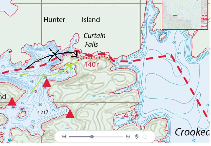
Instead, there's an alternate landing in the bay near that campsite where you can go about your business without worries of current. There are threads on this from years past but I figured with the high water it was worth a reminder.
Take the green route if on Iron and going to Curtain Falls, not the black one. (unless you like adventure and/or swimming) I'm sure there are 100 more spots with high water to comment on possible dangers but this is an easy one at a popular spot. Also shout out to Voyageur maps for getting theirs back viewable online
|
05/20/2024 05:10PM |