| Author |
Message Text |
|
ericinely
|
The Helix 5 is fantastic. Yes, the new ones do come preloaded with maps but they are not very accurate. I would worry less about the down/side imaging capable models (larger transducer, more battery suck) and more about getting a model with auto-chart. My buddy has one with auto-chart and that is far more valuable than the preloaded maps because we can chart the lakes ourselves and more accurately find the kinds of structure that hold fish (especially for Lake Trout). The 7 is nice for the larger screen, but unless you are putting it on a motorboat I dont think it's necessary. If you are mounting it on a canoe or kayak you will appreciate the better battery life and smaller size of the 5". Also, getting a lithium battery is a MUST! I have an old helix 5 and dakota lithium 10Ah and I can get 3-4 solid days of fishing out of it (8-12 hrs/day) if I reduce the screen brightness and turn it off when traveling.
|
|
Karter54
|
Here’s my setup, helix 5 sidi with a nocaqua 10ah, kayak scooty transducer .mount    
|
|
GickFirk22
|
Dakota Lithium 10AH
|
|
CRL
|
GickFirk22: "Dakota Lithium 10AH" Thanks!
|
|
CRL
|
I have. It works well. I use a Nocaqua battery and I have the Navionics chip. BWCA lake depths are hit and miss with Navionics. If in doubt you can always use the Autochart feature to plot your own map. I really like my set up. I use it both on my canoe and my 16' boat (non-BWCA). I have a slightly different transducer mount for the boat. The photos show my set up. I also included the case I modified and how I break it down for travel. I may also get the ice ducer eventually. The 5 inch screen is a little small when running split screen. 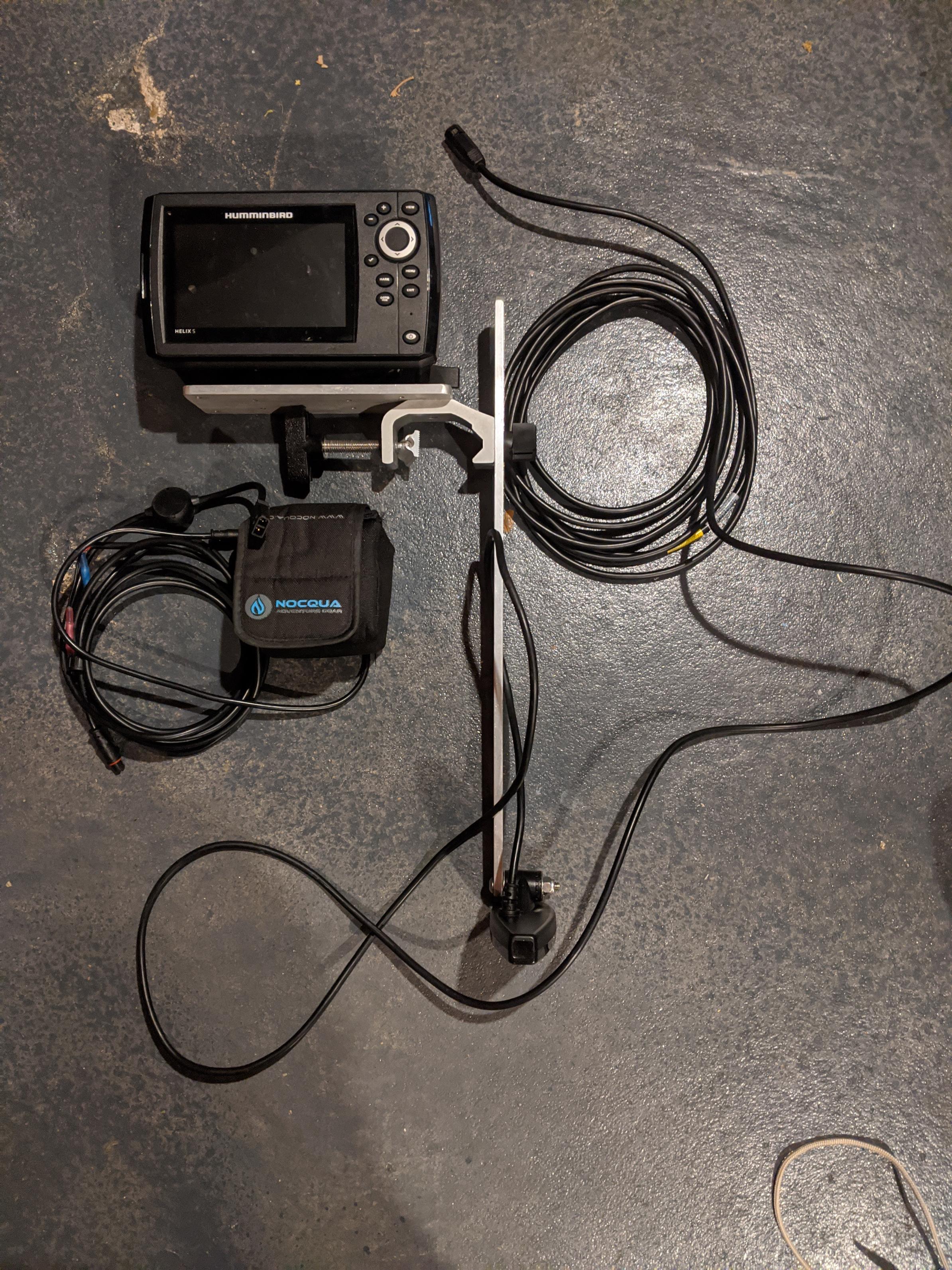     
|
|
ericinely
|
Ive been using the Ice Helix 5 for both winter and summer trips for about 4 years now. The model I bought back in 2017 did not come with maps preloaded. I had to upgrade to a navionics chip, which is not very accurate on BWCA lakes. Shorelines are in the wrong place often, depths are often off by 10-25' in deeper water and the location of reefs/sunken islands is fairly inaccurate. My buddy bought a new Helix 7 with side imaging about six months ago and it did come preloaded with maps that do seem to be much more accurate than the navionics on my unit. If you are going to invest in one of these units for BWCA travel, I highly recommend spending money on a good mount and a Dakota Lithium battery (especially if you upgrade to a larger screen, or get a unit that has side-imaging as they both use more battery). On our last trip, he got about 2.5 days of heavy use (8-10 hrs/day) out of a 10Ah Lithium, I got about 3.5 days on my smaller Helix 5.
I swear by Ram Mounts for rod holders and sonar setups. You will likely have to buy 5-7 different pieces and spend upwards of $100 to get a good mount from those guys, but it is well worth the money if you are trying to maximize fishing time and minimize weight/bulk.
|
|
CRL
|
GickFirk-
What does he use for the battery for the 7"?
|
|
BuckeyeVol
|
Has anyone had experience using a portable Helix 5 depthfinder on BWCA lakes? When I read the description it sounds like most of the lake maps are pre-loaded. I was wondering if anyone has used the maps and how useful they were.
|
|
GickFirk22
|
Following...though I may go with the 7...FWIW my buddy guides up there (both canoe and motorboat) and went from the 5 to the 7 as he preferred the larger screen and has a great battery system for it. I'm looking at the GPS Mega Di model.
|
|
thegildedgopher
|
Several different mapping options available for Helix units so you can't just say "Helix has good maps." Humminbird doesn't make the maps. Navionics, CMAPS, Lakemaster, etc, make the maps. I have used CMAPS and Navionics and they have both been wildly inconsistent. Some times they are on the money, other times I'm in 40 feet of water and the map says I'm aground. On lakes with steep shoreline breaks it can be really bad. The make your own map feature is worth its weight in gold, but for that to really shine you almost need to spend a full day mapping.
I actually don't think any HELIX 5 is a good investment at this point, looking at HB's website. All of the 5 inch models are still on "g2" -- they are currently up to "g4" on the newest models. I can't see dropping $500 on technology that's technically already two generations old, but that's just me.
|