|
07/31/2019 08:41PM |
|
08/01/2019 09:49PM |
|
01/25/2020 12:20AM |
|
08/01/2019 08:48AM |
Cheers!
|
08/03/2019 12:03AM |
|
08/01/2019 12:11PM |
|
08/03/2019 08:32AM |
Off to paddle in the Northwoods!
|
08/02/2019 08:47AM |
|
08/02/2019 08:58AM |
|
07/31/2019 09:49PM |
With that said, I think McKenzie is the way to go when canoeing through Quetico and it's our main navigation map on every Quetico trip. It's all about the detail. The scale of McKenzie maps is larger than the others. The argument can be made about the occasional portage location being off a bit, but you can find that on any map. I don't see that as a big deal.
I'm a map guy so I might very well bring Fisher maps along, too, to compare landforms, portage locations, etc., but McKenzie is still our go-to for travel.
|
07/31/2019 10:57PM |
My philosophy is to use maps as little as possible. Navigate by memory most of the time. If in new territory I'll pick my line and not refer to the map until I need a new line.
|
08/02/2019 09:26AM |
AmarilloJim: "I like DD. You trip with other Texans?"
Actually, the printed maps are sharper than the screen capture image. The sample shown is a bit fuzzy.
I've been known to do that, but mostly its been with my backcountry traveling partner of in excess of 40 years. We've done either a backpacking or a canoe trip (sometimes both) every year since we started, with a single exception. However, my partner may be retiring from this activity after this season.
That said, I've also canoed with folks from other parts of the country on occasion. But, I've yet to travel with someone that I haven't met personally or have someone I know well vouch for them. BTW: That is the principle reason I go to Canoecopia.
dd
|
01/24/2020 07:47PM |
I do the same thing with my Quetico topo maps using OziExplorer. All my waypoints (sites, portages, and various other marks) and comments are overlaid. I print them on 8.5 x 11 paper on both sides with adjacent maps and then have them laminated. They're nice and rigid that way and don't get blown around. But they won't fold. I'm going to consider your method.
Also the Fisher maps look nice too. I've never seen them before.
A couple of things I like to do differently is add the UTM grid in case I want to add a destination on the fly (I don't bring any other maps). Plus I label my waypoints.

|
08/01/2019 08:04AM |
|
07/31/2019 06:09PM |
I am thinking I need to start exploring some new waters. McKenzie and Chrismar Adventure still the best maps for the Q? I actually prefer Voyageur Maps for the BW but don't think that is an option.
I know Fisher Maps are an option; just not my go to.
Thanks kindly for your replies.
(I did run the a search on this topic. I paid much attention to Kanoes words on the topic. He, and others members, will never be gone!)
|
07/31/2019 07:09PM |
|
08/01/2019 08:00PM |
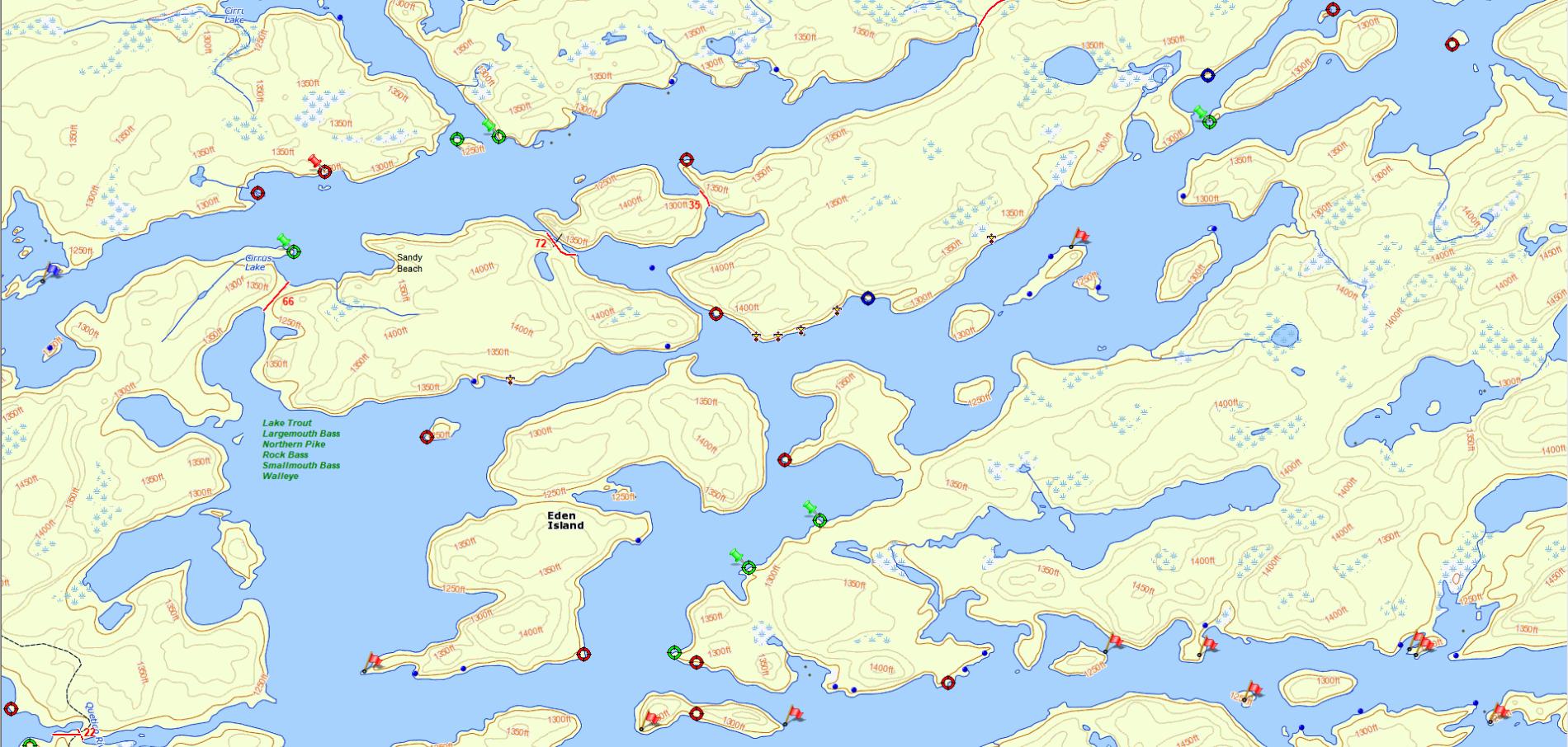
Maps are planned in advance so that adjacent pages can be butted up against another page when it is necessary to see a "big picture" of the area. I also add personal "intel" to the maps. Of course I use software to manipulate and store the maps. And, while I started with downloaded base topo maps of Canada, I preferred something like the color choice on Fisher maps for landmass (making topo lines easier to see and producing better contrast between land and water). I've also created custom icons to mark things like pictograph locations and where I might have caught certain species of fish.
dd
This sample is from my most recent trip (portions of Cirrus and Quetico Lakes shown), but I've also produced them for other provincial parks. The only custom icon appearing on this sample is a thunderbird symbol used to mark pictographs. (Portage lengths are specified in rods ... fewer digits to occupy map space.)
|
08/02/2019 06:16PM |
|
08/01/2019 11:27PM |
TomT: "Very nice DD. I'd like to order a complete set of Quetico please."
Tom -
Because of the time intensive nature of doing this, I have opted to produce maps only for those I’m traveling with. This means that I only have to reproduce what has already been developed. I do have some detail of the entire park, but not to the same extent shown in the sample.
dd
|
08/01/2019 08:03AM |
|
07/31/2019 07:13PM |
|
08/01/2019 12:22PM |
On my first trip to WCPP I had six sets of maps, blown up to my specific route
For a Wabakimi trip (that hasn't yet been taken) I even put a map on a canoe paddle and put poly over it