BWCA Entry Point, Route, and Trip Report Blog
April 27 2024
Entry Point 43 - Bower Trout lake
Number of Permits per Day: 1
Elevation: 1650 feet
Latitude: 47.9469
Longitude: -90.4442
Bower Trout lake - 43
Bower-Trout to Ram: Cherokee - Vista Loop
Entry Date:
September 13, 2008
Entry Point:
Bower Trout Lake
Exit Point:
Ram Lake (44)
Number of Days:
9
Group Size:
2
Planning, packing, and researching for our trip were now ghosts of the past and we headed north at 5 AM. We are creatures of habit, and we stopped at our usual spots for food and fuel. We motored into Duluth at about noon, ate lunch, and then drove along the “big one”. I never stop marveling at the expanse of Lake Superior and her sparkling waters. At the Tofte Ranger Station we picked up our permit and continued on to Grand Marais.
Around 4 PM we checked into Wedgewood Motel and met the proprietors, Amy and Peter. The Wedgewood is a small motel on the north side of GM. The motel is clean, tidy, no-frills, and inexpensive (on par with a “bunkhouse”). Amy and Peter shared a wealth of information with us. They are fellow paddlers and North House Folk School Instructors (Teaching the art of bread and beer making, respectively). Following, a quick room break, we headed into town for an “Uffda Zah Pizza” at Sven and Ole’s. Along the way, we took note of the turn to the Gunflint, and located the South of the Border Café for our 5 AM breakfast.
Recommendations for our digs at Wedgewood and breakfast at SOB came from my post on BWCA.com. We called our plan the “Bannock plan”. Thanks, Bannock. I also picked up many tips about this country from trip reports and other posts. So, for those of you who write about your adventures, others do read them. Thanks for sharing.
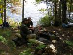
After pizza and a few beers, we headed back to Wedgewood to prepare for the next day. In a moment of stupidity, I convinced Matthew that we should look for ways to lighten our food pack. Never ever again will I remove “too much” trail mix (my mix of M&M’s, salted peanuts, and raisins) from the food pack. Before retiring I listened to Amy’s weather radio. The big question on my mind was the direction of wind for our crossing of Brule on Day 2. [paragraph break] Pictures: 1) Packing and checking the list twice, 2) On Highway 23 south of Marshall, MN, 3) Lake Superior 


It is a little before 5 AM and Matthew and I are standing outside the SOB café waiting for the opening. At 5 sharp the doors open, we walk in, and it didn't take a sociologist to see that the locals call this spot breakfast. “Hi boys, coffee?” our waitress asks. For the regulars, she knows the drill and simply serves it up without a question. Smiles were everywhere, even for us “who ain’t from around here”. What a breakfast we had and it was served in a flash with plenty of SOB coffee. The SOB coffee is made to get you on with the day.
I guess we were on the way to Bower-Trout at 6 AM. It was dark, and the road was fogged in. I had driven to and walked the trail to Bower-Trout back in August under a bright summer sun. Now, in the dark and fog, things looked a whole lot different, and I got confused with the turn onto Forest Service Road 325 off the Gunflint Trail.
On pulling onto a road that looked like a dead end path to a gravel pit, my son asks, “Dad, you sure you know where you are going”? “Yeah, now I do, before, I didn't, the parking lot is just down the hill”. At the parking area, we found one lone vehicle. That was a good sign, now we know how many people are back there. It was now 6:45 AM, and we were glad that we got breakfast in early.
The trail to Bower-Trout follows an old railroad grade. It is a “super highway” of a trail, and we won't be seeing anymore like it. There were plenty of signs that moose were also very fond of this country. Matthew was first down the trail, and nearing the lake, he exclaims “what the hay is that doing here”? And there, occupying the only firm ground at the landing, was an aluminum row boat! Now that was a trick getting that monster in here over a 67r portage. But, why was it left blocking the path?[paragraph break]Picture of the row boat at Bower-Trout[paragraph break] [paragraph break]How are we going to get around it? I think I’ll just swing the stern of that tin can out from the logs to make room for the canoe. Good Idea. And with words hardly out of my mouth, I stepped out onto what looked like solid ground. In a wink, I was swallowed to my thigh in bog. To keep from sinking, I grabbed a root with one hand and held onto the row boat with the other. In the process, my finger was gashed. Damn, the day started good, but that sure soured things. I was wet before we started, bleeding on the canoe, and really thinking bad thoughts about the owners of that boat.
With that behind us, we launched into the fog at 7:20 AM. Low visibility kept us hugging the north shore till we bumped into the portage on the west side. There are five short portages from Bower to Swan, and each rather pretty. From the look of the trails, the South Brule River also uses these portages on occasion. We could have used a few more inches of water in the river. There was one spot on Dugout Lake that nearly had us lining the canoe. That would not have been pretty considering the bottom had beach-ball-sized boulders, and the shore was lined with thick brush. We only squeaked through after considerable maneuvering and some removal of excess epoxy from the hull.[paragraph break] Under different circumstances, this string of lakes would be a great leisurely paddle. But, on this first day, we were all about getting to Vernon and not about smelling the roses on the way. Swan Lake was a pretty one, and had we been in our right minds, we would have stopped for the day. The paddle west up the meander was a gem. Most of the river bottom is sand, and on a hot summer day, it would be a great wade. There were times when we thought that we had missed the portage. But, magically the portage appeared on left when the river started to disappear into the brush.
The 292 lay ahead of us, and I do not have kind words for this trail. The trail was overgrown and basically cuts through brush the entire way. We were in a hurry, had not taken time to eat lunch, and we were possessed with making Vernon. Matt was as stubborn as I, and neither of us called for a break. He pushed me, and I pushed him. On the Vernon side, we ate our power bars and felt a new found energy. What do they put in those things anyway?
On Vernon, we found the north camp taken, but the SW site was open. It was now 2 PM, and there was no question, we stop here. Rain held off until just after supper, and then the sky opened up. We were not in the mood for putting up a tarp, and it was a natural to crawl into the tent at about 7 PM. In September under a stormy sky daylight is pretty well gone anyway. Our miles came with a lot of work today, and it did feel good to crawl into the sacks. It stormed most all night and a north wind picked up. The increase in wind caused me some anxiety, but as long as it stays from the north, our crossing of Brule should be OK.
Today we saw 1 party camped at Bower-Trout Lake and 1 party camped at Vernon Lake. [paragraph break] Pictures: 1) Morning fog on Bower-Trout, 2) East side of Bower-Trout, 3) Dugout-Skidway burn 


We were up at 6 AM and feeling a good stiff breeze from a NE direction. Both Matthew and I had been apprehensive about Brule Lake. We wanted to get this lake behind us, and today was the day. Are we doing the right thing? We will not know, until we see Brule.
We were on the water at 8:15 for the short, but windy, paddle to the portage. The 55 rods from Vernon to Brule were steep, and our blood was pretty well circulated by the time we assembled our gear on Brule Bay. We shoved off into Brule at exactly 9:15. We could not get a good feel for the wind direction until we entered the main lake near Brule Island. Away from the little bays, we found a brisk and steady NE wind and that would be at our backs. All we needed to do was to hug the north shore.
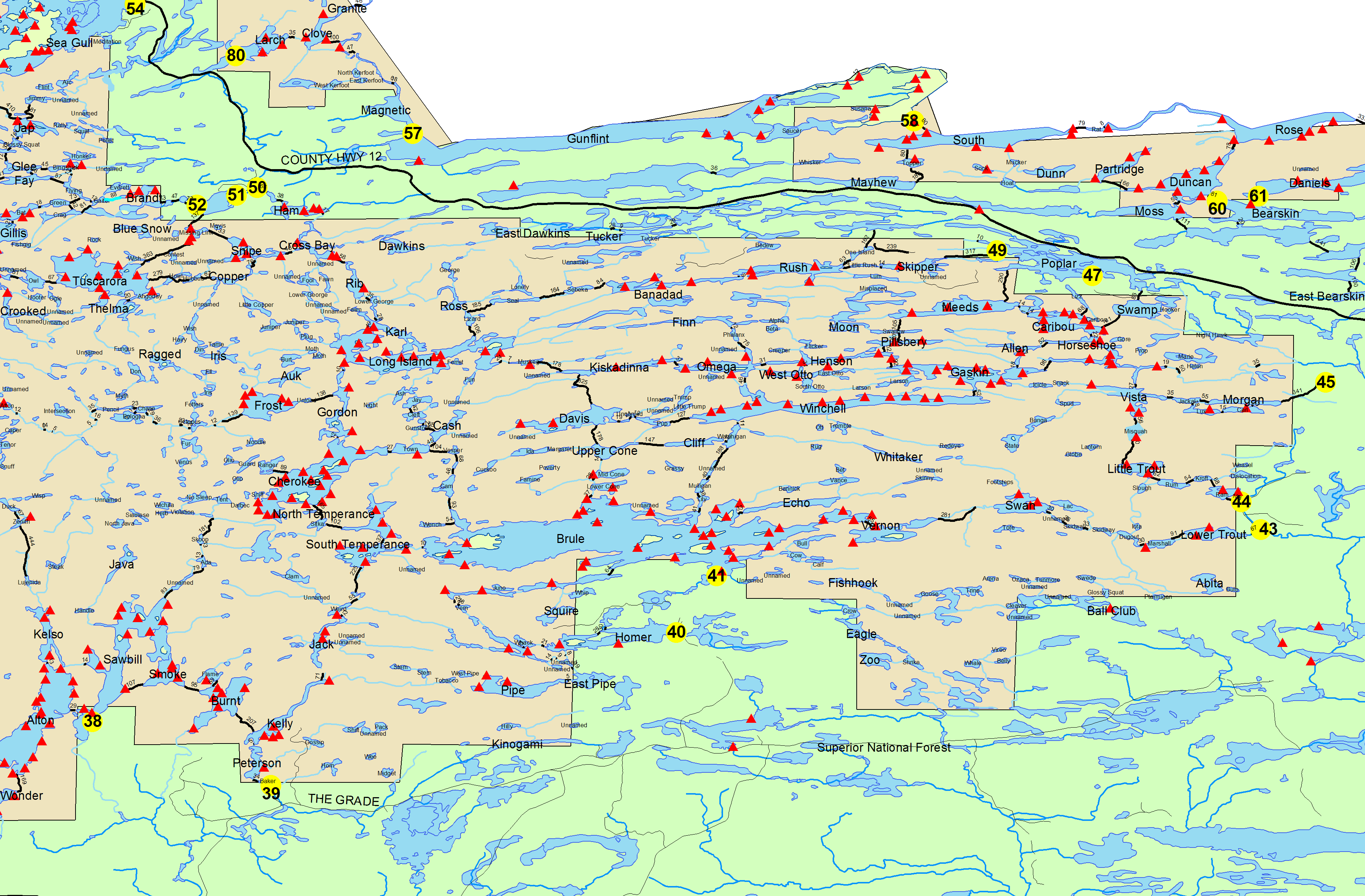
It is about 8 miles from the NE end of Brule Bay to the west end of Brule. We cleared those miles in 2.5 hours including a snack break along the way. When we hit the larger bays like North and Cone, we paddled north into the bay until the waves looked friendly, and then shot across to the other side. Several times we paused in the lee and watched the south side of Brule. We could actually see white spray thrown into the air as waves crashed against the rocky shore. Brule Lake is a most impressive Lake. The lake is big, and the topography is candy for the eye. The day was not sparkling bright, rather it was misty and rainy, and this added a touch of mystique to our Brule experience.[paragraph break]Pictures show 1) Brule Lake east of Brule Island and 2) Brule Lake near Cone bay 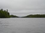
 [paragraph break] For the distance traveled, this paddle was one of the easiest days we have done. Camp was made on the west side of the island at section 17. With these first two days now under our belt, we could slow the pace. We expected a few trials in the days ahead, but in our minds the worrisome portion of our loop was done.
Section 17 camp was not something to write home about, but it was comfortable. The bays and little islands west of us were very picturesque. But with the wind, we did not explore them. Easy firewood was very scarce, but enough was scrounged up for the night. Towards evening the scattered showers went away, and it was supper time, fire time, and Cognac time (in about that order, give or take a few sips). A big full moon rose behind the trees, night became day, and Brule sparkled like a lady in diamonds.[paragraph break]Pictures show 1)Full moon at section 17 camp Brule Lake and 2) the evening fire watch at camp 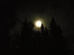
 [paragraph break] Today we saw a number of parties camped on the east end of Brule and encountered about 7 canoes going in the direction opposite of our westerly course.
Matt and I were up at 6 AM and looking forward to the day. We had studied the maps, and we figured today would be an easy day in pretty country. The elevation of Brule Lake is 1834 feet and many of the cliffs that lined the lakes ahead were in excess of 2000 feet. We stoked the boilers with sausage gravy and biscuit, washed it down with coffee, and shoved off for the north at 8:45.[paragraph break]Morning at Brule. Picture of lake looking west from section 17 campsite[paragraph break]  [paragraph break] We had named the little string of lakes from Brule to Town as the “mechanic series” (with names like Cam and Gasket). These lakes were beautiful and the cliffs on Brule that guard the entrance to the Cam Lake chain are nothing short of phenomenal. On Brule, we could see many trees that were twisted and laid down from the big blow down. Cam Lake was a gem and it reminded me of an alpine lake surrounded with ruggedly steep topography. We should have paddled every nook on Cam Lake.[paragraph break]Pictures show 1) Heading toward Cam Lake portage on Brule Lake, 2) Closer look at the cliff shown in picture #1, and 3) Brule-Cam portage[paragraph break]

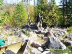
 [paragraph break] There are 4 portages from Brule Lake to Town Lake. These trails are not overused. Combined portage distance is 330r, and that is only about 20r more than following South and North Temperance to Cherokee. We paid the dues to get through. It took us 4 hours to travel from the section 17 campsite on Brule to the campsite on Town. Hands down this was the trickiest leg of our loop from Bower-Trout to Ram. The rocks were slippery and each step had to be carefully planned in advance. We could not take our eyes from the trail for a second. One notable time on the entry to Vesper I found myself doing a special little dance while balancing on a boulder and trying to free the bow of the canoe from the grips of a western cedar. Slick dance steps on the portage were common and they took their toll on the body.[paragraph break]Pictures show 1) Cam Lake and 2) North end of Gasket Lake[paragraph break]
 [paragraph break] We figured it could not get any worse after the Brule-Cam portage, actually it did. Once started, we were committed. Following the combined effort of these 4 trails, the notoriously tough portages that lie ahead like Muskeg-Kiskadinna and Misquah-Trout did not seem bad at all. Actually I would prefer a trail like Muskeg-Kiskadinna than the boulder gardens that we traveled between Brule and Town.[paragraph break]Photo shows Town Lake camp site[paragraph break]
  [paragraph break] We nearly paddled past the camp site on Town Lake. This was not a spot that says, hey, camp here, great view. The best part of the camp was that it was ours. After pulling the gear from the canoe and hauling the canoe up, we sat. I popped 2 Aleve in anticipation of the aches on cooling down. The hillside behind this camp was littered with the remains of the blow down. Fire wood within a stones throw was in ample supply, and we split up a bunch for the evening. The rest of the day was spent lazing about.
Today we saw no other people.
We were up and about by 6 AM. The day had all the ingredients of a good day as we made the short paddle to the Cherokee portage. With low water this portage presented us with a couple false starts, but we had fun with our creativity.
We first carried to a small pond, and figured here we are. On looking out over the pond, we discovered (falsely) that we can’t get there from here. With some scouting we discovered another trail segment leading to another pond. OK, let’s take a look with just the packs. Oh, crap, this was worse than the first one. So, back we go to pond 1.
We loaded the canoe and headed into the apparent dead end. Surely, there has to be a way through. Ah ha! So, this is where the water goes, when there is water. In the shallows, we stepped out and gentle nudged our canoe forward through a few twists in the channel and one lift-over. At deep water we hopped back in, took a few strokes, and remarked to each other “That was easy enough, and this is probably Cherokee”. The scenery on the north end of Cherokee fell short of what we saw on the "Mechanic Series". We were glad that we took the Cam Lake route.[paragraph break]Pictures show 1) Portage/float into Cherokee Lake from Town Lake and 2) Upper end of Gordon Lake[paragraph break] 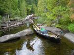
 [paragraph break] I had read a trip report where a canoeist wrote of going down the NE bay looking for the portage into Gordon Lake. Coming from the east side, I could see how easy that would be to do. At the portage there was a nice gravel beach. On the left of the beach was a rock ledge, and on the right, thick brush. Parked broadside to the portage, and fully occupying the nice gravel beach was a fully loaded Kevlar canoe that was half-in and half-out of the water. No one was in sight. Well I’ll be. It was time to wet-foot. We unloaded our packs over the rogue canoe, and then hauled our canoe up and over. As we found out later, the owners were down on the Gordon side waiting for the other canoe in their party to show up. So much for portage trail etiquette.[paragraph break] The water ways between Cherokee and Long Island were an idyllic paddle. The surface was smooth as glass and we slowed our pace enjoying the feel of the day and the country. On the Long Island River, we almost took an unplanned bath. We had become high centered on a gravel bar, and it was only a matter of squeezing a few more feet to get into deep water. Matthew was leaning over with his full body on the paddle pushing while I stepped out with one foot to take some weight off and push. The canoe broke lose. Matthew almost got sucked overboard holding onto his paddle that was buried in the gravel, and I found myself doing the splits with one foot in and one foot out. Whoa, canoe! I ended up in a graceful position with my butt on the floor and a foot in the water. Matt was on his knees, but still had his paddle. When the rocking stopped, Matt grinned, “that was close”.
Long Island Lake invited us to explore her little bays. The day was perfect, and we eased the canoe to the north to find another one of those unassuming Boundary Waters camps. On first sighting, the camp on Karl didn’t seem worth the effort to stop. But, it was close to lunch, time for a break, “let’s take a look”. We ate lunch around the fire pit, and slowly the site started to grow on us. From the looks of abundant piles of undisturbed otter scat on the rocks, the site was also a popular spot with the otters. The decision to stop had been made. Today we will look no further, let’s get the tent up.
We had the whole afternoon for dinking around camp, and it was nice not having anything in particular that needed doing. Matthew did some repairs on the sitting logs, I cut a little firewood, and cleared the remains of a fallen tree from the latrine trail. Time always seems to go by so quickly. One minute you have the whole afternoon and the next minute it was time for supper. In the fall, daylight goes quickly after supper.
That evening we had a beautiful fire and an almost full moon. We fed our fire, sipped Cognac, and talked in hushed tones. The light from the moon lit the entire bay behind us. In front, the water was shaded from the light and we listened to the sounds of the forest and water; the splash of a fish and the more ominous crack of a twig somewhere up behind us in the dark of the forest. One sound kept reoccurring. What is that sound out there? Our ears tunes in. I think that is an otter. We could not see him, but we could visualize the actions from the sounds. We think he was gnawing on crayfish, or maybe he was catching fish. Whatever it was, he sounded like he was enjoying the meal splashing about in the dark. We were in no hurry to hit the sack, but finally the wood ran out, and it was time. [paragraph break] Pictures show 1) Karl lake and 2) Karl Lake camp [paragraph break] 

We were up and about at 5:30 AM, and in no real hurry to leave our spot. I had a great night sleep, and the day promised to be a good one. We had a leisurely breakfast as the morning fog slowly lifted. Pancakes and pork patties, washed down with several cups of our special cowboy coffee, should power up our engines for the Muskeg-Kiskadinna portage.[paragraph break] Picture shows Entering Long Island Lake from Karl  [paragraph break] Our morning paddle down Karl was sweet. Not a breath of wind was blowing and the lake mirrored back the forest perfectly. On Long Island we paddled slowly between the islands on the north side and that shielded our eyes from the old burn on the south shore. From the lush green we then entered the scrubby re-growth of the east bay, and that was an eye opener. There is nothing pretty about burned out areas, and the land we were now seeing was part of the 2006 Famine Fire.[paragraph break] Picture taken on the east end of Long Island Lake near the narrows showing the old burn [paragraph break]
  [paragraph break]We were running out of lake as we anxiously looked for the portage from Long Island Lake to Muskeg Lake. The land did not look inviting in the small cove leading to the trail. Downfall extended into the water and it presented a formidable barrier. I was beginning to wonder if these trails had been reopened following the fire. Near the portage the water way narrowed and there we spotted the work of the saw. Ah, portage ahead.[paragraph break] Pictures shows the landing at Long Island - Muskeg portage and 2) paddling the meander to Muskeg Lake[paragraph break]
 [paragraph break]I would have liked to travel here before the burn. But, even in the post burn era, the water way that meanders through the marsh leading to Muskeg was an interesting paddle that ended all too soon at Muskeg Lake. Most of area around the small Muskeg Lake was spared from the burn. Next stop, the wall.
We were expecting the worst on the portage into Kiskadinna. The whole portage is not that bad. There is a gain of 147 feet between Muskeg and Kiskadinna. A portion of the trail seems straight up and it did spark a fire in my legs and had me puffing as I approached the top. After that, it was basically an easy stroll to Kiskadinna. In comparison to the string of portages that we did on the “mechanic chain” of Day 3, I think that the “notorious wall” was, in fact, an easier go. But, we also hit this portage well rested and well fueled.[paragraph break]Pictures show the steep part of the Muskeg-Kiskadinna portage (some call it the wall)[paragraph break] 
 [paragraph break] Kiskadinna Lake is narrow and about 2 mile long. Author Beymer writes that it is an unattractive lake in comparison to its neighbors. We do not judge a lake by its neighbors and we found the lake a nice comfortable paddle. The lake runs parallel to a low cliff on the south shore, and that was in contrast to the north side which is flat, low and a “dog-hair” thicket of small spruce. The campsites were nothing to write home about. As we saw it, the most difficult thing about camping on Kiskadinna would be in finding a tree suitable for hanging a food pack. We speculated that we would find our portage at a hole in the cliff. That is about what we found.[paragraph break]Picture of Kiskadinna Lake looking east from the portage[paragraph break]
 [paragraph break] The 35 r from Kiskadinna to Omega resembled a stairway from the lake. The portage is short and basically up one side and down the other. The first camp site on Omega was open, but we had been told of a real nice spot on the south shore, and that is where we headed. We had used up a good bit of time getting our miles in and we were approaching our 2 PM witching hour. It was time to stop. As luck would have it, the perfect spot on Omega was the perfect spot for someone else. That is the problem with knowing too much, and rather than going back to the site we had just passed, we headed to the camp on the north end. It was open, and it was time to stop.[paragraph break] Pictures show 1) Kiskadinna-Omega portage and 2) Omega Lake looking south from our north camp site [paragraph break]
 [paragraph break] The north site on Omega sits high, and it offers a commanding view of the lake. Pretty, yes. Practical, no. I do not take much joy anymore in hauling gear and fetching water over a goat trail. Fire wood was scarce, but there was ample flat ground for our little tent (and many more). Matt and I tended to our camp chores, and then dusk was setting in. Our small fire and our rations of cognac capped a nice day.
Of the trip, this day was my favorite. The weather behaved. I enjoyed the diversity of the country we passed though including the portages. We saw one canoe on Long Island Lake and Omega Lake, and spotted only one other camper.
We were up and about at 6:15 AM, and one look at the sky caused us to hustle knocking down the tent and packing while things were still dry. Our timing was good, because as we finished, the rain came in. Breakfast was a SPAM and cheese omelet. This is an easy, no mess meal when done in the bakepacker. So even in the rain, breakfast was enjoyed and the coffee savored. Our day would be a short easy jaunt, and our strategy was to position ourselves for the following day when we would paddle through the popular Horseshoe and Vista lake country.
We have enjoyed paddling the small lakes, and we stayed with the small ones by continuing into Henson Lake rather than dropping down to Winchell Lake out of Omega. On Henson Lake, the rain let up and the day turned nice. We have been lucky with the weather. Showers have come and gone and not hung over our heads for days.
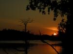
On Pillsbery, we spotted a nice small camp site on the west end and decided to stop early. This camp has not seen heavy use and it was interesting to find that the old style latrine had been replaced with the new type. I am not real fond of the looks of the new square latrines. They don’t fit in, and they don’t fit me. It has been an easy day, and that is OK. The remainder of the day was spent exploring about and generally being lazy. There were plenty of signs of heavy moose traffic around this camp earlier in the year. Now, the place was deserted. So far, we have seen no big game. Today we saw two canoes on Pillsbery and heard the weather radio of campers on the south side of Henson as we paddled across. [paragraph break] Pictures: 1) Pillsbery Lake from camp, 2) Pillsbery Lake sunset 
We were up at about 6AM. I had a restless night. The wind picked up as we were bedding down and it continued to howl most of the night. The tent pad at this site was up hill from the lake, and it seemed every gust was amplified in the branches of the poplars. Between the wind and the location, our tent was perfectly dry this morning. It is so much easier to pick up dry gear.
Breakfast was biscuit and gravy. I think that is one of our best meals. We make the biscuit the night before, so in the AM we only need to make our sausage gravy and coffee. This meal sticks to the ribs too. In the distance a small rumble was heard. Thunder?
The paddle down Pillsbery was idyllic and the 95 r into Allen was a nice easy portage. On the trail we spotted a very nice and very fresh bear track. The bear had been using part of the trail and we had just missed an encounter of the bear kind.[paragraph break]Picture shows a fresh track of company on the trails[paragraph break]  [paragraph break] We double portage, and that requires leaving the food pack unattended. I felt a little uneasy when we turned our backs on our food. Once on Allen rumbles became more pronounced and we were sure that any minute we were going to get dumped on. We made short work of Allen, crossed into Horseshoe, and headed for the 21 r into Vista. This entire string of small lakes was a gem to paddle, and the portages were not killers. The killers lie ahead after Misquah. Campsites that we passed on Horseshoe were empty, and they looked like they get very heavy use. Our desire was to camp on Vista.
The rain held off till we hit the 21 r portage into Vista. We suited up and waited out the heaviest of the rain to pass. Wind was directly out of the south and that made our launch off the boulder field into Vista a bit tricky. The camp on section 29 of Vista was a terrible place requiring several mountain goats to get up to it. Once on top, both Matt and I came to the same conclusion; let’s get out of here rain or no rain. There was a nice looking camp on the south end, but it was taken. There was no sense in going back to pick-up one of the sites that we had passed, so it was on to Misquah.
The portage into Misquah Lake is only 50 r. Most of it is uphill, and most off it was slippery following the rain and the new layer of fallen leaves. On the lake side, we put in at the first water we saw without realizing that the proper entry was a few rods further. No matter, we loaded, the canoe floated, and we made our way into deep water. We almost paddled right by the camp on the south end. It was somewhat hidden back from the lake. “Whoa, was that the camp site we just passed’? It was vacant, and it was time to stop.
The Misquah camp is another one of those spots that tended to get better as we made ourselves at home. It was definitely protected from the winds, but there was no boulder-free flat spot for tents. We creatively pitched our tent over a rock. Actually it worked out pretty good. There was a great campfire ring, and the fire wood was plentiful. We had a good fire that evening
Across the lake from our site was an old burn, and from that country we had been hearing the distinctive call of a moose in love. This lover’s concerto kept us amused, as long as he stayed over there, and didn’t come looking for love on our side of Misquah. Today we only saw the one group of campers on Vista Lake. [paragraph break] Pictures: 1) Ahead of the storm on Allen Lake and 2) Misquah Camp 

Matt and I rolled out of bed at about 6:30. Today is September 20th and my desire was to find a perfect camp on Little Trout to celebrate Matthew’s birthday. Our trip was on target, because we had picked Little Trout as “birthday camp”. This decision had been made with the thought of exiting the BWCA on the following day. Our birthday breakfast consisted of our great favorite SPAM and cheese omelet. The day was bright with no clouds and very little wind. We had one portage on the agenda and Beymer painted a grim portrait of that portage. Could that be the moose still calling out there?
We had just a short hop to the portage from our camp. Beymer advises that this trail is one of the toughest in this part of the BWCA. His description is probably correct. However portages, are all about what is on the plate for the day. This was our only portage, our bodies were rested, and the trail went well. The path is interesting and presented much diversity in the landscape. I think the Muskeg-Kiskadinna climb was steeper.
The trail, up to the first climb, was relatively flat and easy enough. We dropped our gear at the base of the hill, returned to the lake for our remaining packs, brought them up to our first drop, and unloaded. Ok, time for the climb. After the climb there is a short down hill run, then a flat board walk through the swamp, then another climb, and then (finally) downhill to Little Trout. Along the board walk there were plentiful signs of wolf track in the mud. On the breaks to Little Trout the trail enters an old burn on high ground and here there was a nice view of the lake below. I found the footing on the steep downhill section into Little Trout more difficult than the climb. I had to keep the bow pointed low to avoid hammering the stern into the rocks.[paragraph break]Pictures show 1) Portage to Little Trout Lake (after the first climb) and 2) board walk section[paragraph break]
 [paragraph break] Before settling on a camp we explored the entire lake. We were alone. Little Trout is a pretty one. Only the section of the lake next to the 190 r portage was affected by the old burn.[paragraph break]Pictures show Little Trout Lake and the portage landing at Little Trout[paragraph break]
 [paragraph break]The camp site next to the 190 r escaped the flames, and that is where we settled at about noon. The rest of the day was ours, it was a beauty, and very relaxing.
This fire ring at this camp was a sorry looking mess and in need of a little TLC. Matthew tended to that. I set up the tent, gathered wood, roamed the woods and just relaxed. Some time in mid-afternoon two guys came in from Vista to fish for trout. They stopped by and we exchanged stories of great adventure. They were staying at the mountain goat site on Vista, and showed us digital pictures of the site "before" and "after". Their work was admirable and they complemented Matthew on the cozy fire ring. The guys said that Little Trout was good for trout, but they left empty handed. We had the lake to ourselves. It was a good remote feeling.
We ate good this day, and we didn’t work too hard. For lunch Matthew cooked up Cache Lake Scones and we smothered those with stewed peaches. If that wasn’t enough, we then made fried SPAM and cheese sandwiches. Supper was Lasagna and chocolate cake (another easy bakepacker favorite).
When daylight started to fade, the fire was lit and the cognac broken out. Tonight there were no rations. It was our last night on the trail. We could feel the coming of fall on our backs. This was a fitting night to celebrate both the trip and Matthew’s birthday. The fire cut the chill and the firewater warmed my stomach. Life was good. [paragraph break] Pictures show Matthew repairing the fire pit at Little Trout camp and a Father/Son shot at Little Trout camp[paragraph break]
We rolled out of the tents at our usual hour and went through camp chores for a final time. These are bitter sweet moments. We know the trip is done. On one hand we are ready to come out, but on the other we did not want to let it go. Our last breakfast was a Mexican omelet and mucho coffee. Camp was picked up, and we left our campfire ring with a neat little pile of kindling. It was picture perfect, and we only hope that the next visitors will find this spot as special as we found it.[paragraph break]Pictures show our last breakfast on the trail and a departing shot of the camp[paragraph break]
 [paragraph break] The portage into Rum was a good kick start to the day. Up, abruptly and down just as fast. Great view from up here, huh? The Rum to Kroft trail was mostly flat, and the hand of fall hand had painted the leaves beautiful shades of orange and gold just for us. At Ram we paused at the portage for a father-son picture, a bit of meditation, a sip of cognac, and a smoke. The last lake. The portage out of Ram Lake is a little bit up and mostly all down. There was one car in the parking lot (Entry #44) and it likely belonged to the campers that we passed on the west end of Ram.[paragraph break]Pictures show Rum-Kroft portage and climbing out of Ram[paragraph break]
 [paragraph break] We only have one more thing to do and that is to retrieve our truck form the entry at Bower-Trout (#43). With that, we turn our backs on our equipment and head off for the mile walk to entry 43. Hunting season has started, and several pickups passed us as we walked along. They were hell bent on finding their game. I know we didn’t present a picture of someone that you would offer a ride to. But, at least you guys could have slowed down as you passed. I know we needed a bath, but I did not appreciate the dust bath. Thank you.
Finally, there is the truck and the tires are on it. Good sign. The glass is intact. No trees have fallen on it and I hear the reassuring click as the locks open. We climb inside. Damn these seats feel real comfy don’t they? Now, back up the road to collect our gear, pack, and salute again with a Heineken, salami and cheese.
We had told Amy and Peter at Wedgewood Motel that we might drop by after the trip. We did not want to get locked into reservations, so it was a crap shoot if there was room at the Inn. At highway 61 we headed north out of GM to Wedgewood. Maybe we will be lucky. The No Vacancy light was on, but we pulled in. Again, Amy was delighted to see us. She explained about not having time to clean up the rooms (except for reserved guests) and thus, the No Vacancy sign. She had one room clean, smiled, gave us the key, and we talked up the trip.
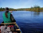
After showers, we headed into GM to find a steak and beer. In the morning we stopped into SOB cafe and fueled up our bodies for the drive back to South Dakota. I think it was easier leaving GM this day than is was leaving Little Trout yesterday. [paragraph break] Pictures show 1) Ram Lake, 2) Matt (PitchStump) and Joe (HighPlainsDrifter) getting ready to paddle our last lake (Ram), 3) The last portage and all down hill to the entry 

Everything after Day 1 and 2 seemed "not so bad" including the notorious "wall" from Muskeg to Kiskadinna and the Misquah - Little Trout portage. However, we also hit each of the difficult portages on short days, well fed, and rested. The state of your mind has a lot to do with how you remember a difficult section of trail. We stayed away from Winchell and followed Omega-Henson-Allen-Horseshoe to get back to Ram. I loved the small chain of lakes and I have no regrets about the path we selected.
The big negative about this loop was the constant encounters with "new entry points" as you loop around. Basically you never move away from being in close proximity to entry points (with the obvious exception of the start and finish). Actually we did not see many people at all. But from the looks of the camps, the country around Brule Lake and Poplar Lake gets hit hard. We also tripped late season and that has a lot to do with encountering other travelers. The big plus for this loop was the diversity of the country, beautiful hills, very pretty lakes, maintained portages, and solitude. My favorite day was Karl to Omega. My favorite camps were on Karl and Little-Trout.