|
 Boundary Waters Quetico ForumListening Point - General Discussion Curious About Border Portage
|
 Forum Sponsor

Author
Text
")


04/19/2017 07:10PM
September 2015 my wife and I went from EP 55 to Ottertrack across the "monument portage". This was my second time in that area, the first in 2011. We met 3 older Canadian guys, 80 something, and one of them told me the American government had clear cut that portage about 100 feet wide shortly after 9/11/2001. Based on my observations, without any knowledge of what actually happened, I would have to say that's possible. Do any of you know if this is true or not.
"...And the days I keep my gratitude higher than my expectations, .......well, I have really good days". Ray Wiley Hubbard
04/19/2017 10:54PM
It was done in order to monitor terrorists netting ciscoes from Sag. It seems to have successfully stopped the illegal ciscoes from migrating at will across the border.
Another theory that has gained some traction is that it was done on an experimental basis to allow parties who meet on the portage to continue on their way without stopping to visit or yield, as that could result in a violation of the nine person rule.
Fortunately, it also had the unintended result of reducing the mosquito population in the immediate area.
Livin' the dream. Just another day in Paradise...

04/20/2017 08:44AM
been across that portage in 1992, 2007 and 2010. it got progressively wider the last few years. there is a company that has traveled each summer/fall the past few years and that is exactly what they are doing, widening the portages (supposedly only on the MN side). they were pretty "mums the word" on the exact reason why. wish i could remember the name of the company on their vehicles, i thought it was some gov't agency.
04/20/2017 08:59AM
quote aholmgren: "This is from 9/2012, my 1st time through, I recall noticing it was cut wide recently/years ago"
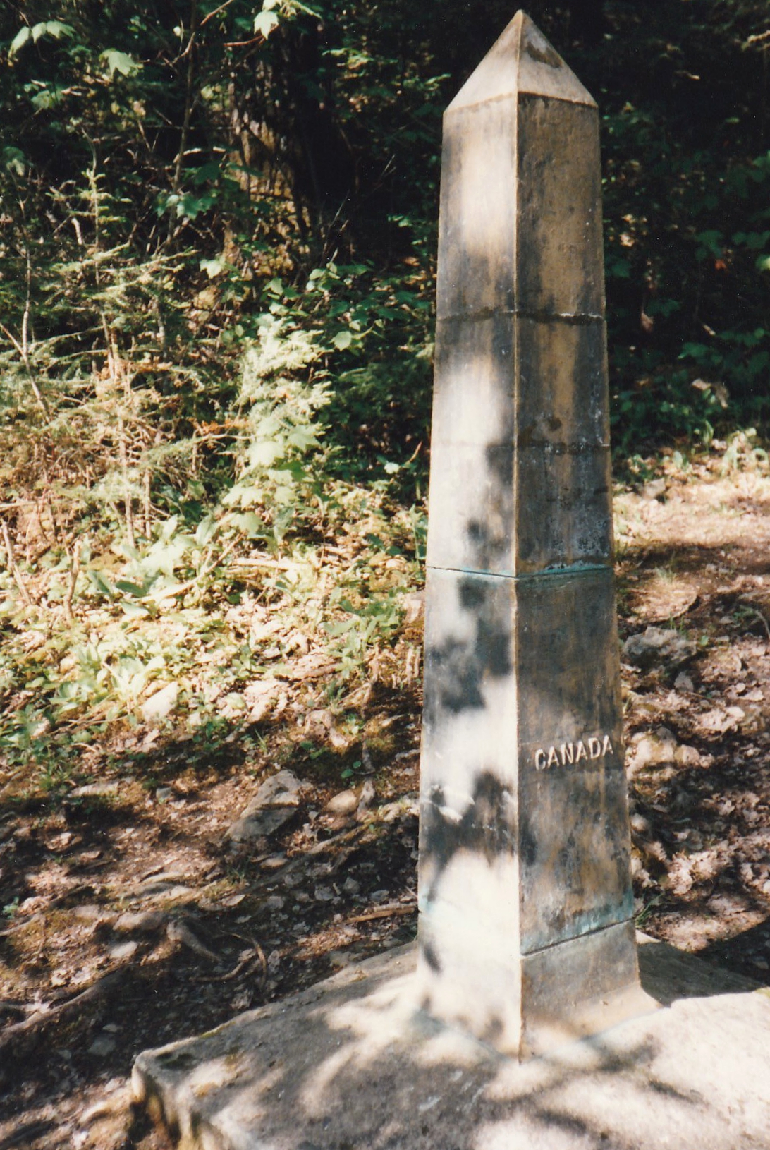
Hmmm, I like the old marker better.
"Let us live so that when we come to die even the undertaker will be sorry." Mark Twain
04/20/2017 11:08AM
One of the cool things about Google Earth is that you can view older images using the timeline feature. I made a couple of screen grabs for comparison: May 2008 and September 2013. There are other images from June 2010, April 2011, and October 2015 but the resolution is poor.
You can make your own assessment in the photos below:

Without a doubt, there are some areas of the border that have been "enhanced" for surveillance, but if you scan along the Minnesota and North Dakota borders with Canada, there is little evidence that these lightly populated areas have seen any modification other than the the routine maintenance that has been done for years.
"Said one of these men, long past seventy years of age: 'I could carry, paddle, walk and sing with any man I ever saw. I have been twenty-four years a canoe man, and forty-one years in service; no portage was ever too long for me. Fifty songs could I sing. I have saved the lives of ten voyageurs. Have had twelve wives and six running dogs. I spent all my money in pleasure. Were I young again, I should spend my life the same way over. There is no life so happy as a voyageur's life!'"
04/20/2017 11:30AM
quote thebotanyguy: "One of the cool things about Google Earth is that you can view older images using the timeline feature. I made a couple of screen grabs for comparison: May 2008 and September 2013. There are other images from June 2010, April 2011, and October 2015 but the resolution is poor.
You can make your own assessment in the photos below:
Without a doubt, there are some areas of the border that have been "enhanced" for surveillance, but if you scan along the Minnesota and North Dakota borders with Canada, there is little evidence that these lightly populated areas have seen any modification other than the the routine maintenance that has been done for years. "
Easily one of the best features in Google Earth. Its really interesting to see how features change over time. I particularly like looking at burned/logged areas and the rapid return of vegetation.

04/20/2017 04:54PM
quote maxxbhp: "September 2015 my wife and I went from EP 55 to Ottertrack across the "monument portage". This was my second time in that area, the first in 2011. We met 3 older Canadian guys, 80 something, and one of them told me the American government had clear cut that portage about 100 feet wide shortly after 9/11/2001. Based on my observations, without any knowledge of what actually happened, I would have to say that's possible. Do any of you know if this is true or not. "
I was on a trip a week after 9/11 and passed through there, the portage was narrow enough to be brushed by foliage (IOW, the typical BWCA portage).
I passed thru again a few years later, it may have been trimmed, but no cutting. I'd have to look on my other computer to see the exact year of that trip, but I'm guessing 2003 or 4. When was the fire? The trip was the fall after the fire in the Seagull, Alpine, Ogi area.
let science, not politics decide, ... but whose science?
04/20/2017 05:43PM
Never heard that, but I know why they would think that. Monument is a busy portage, well traveled area, and I could see the government wanting to make it nice and wide so people would have room to pass each other. Landing on the Ottertrack side is massive too by canoe country standards, I suppose for the same reason.
aka HermitThrush "Such sights as this are reserved for those who will suffer to behold them." -Eric Sevareid
04/20/2017 06:52PM
quote SaganagaJoe: "Never heard that, but I know why they would think that. Monument is a busy portage, well traveled area, and I could see the government wanting to make it nice and wide so people would have room to pass each other. Landing on the Ottertrack side is massive too by canoe country standards, I suppose for the same reason.
"
I'd guess you'd know this area as well as anyone, but what confused me was that the portage trail itself is pretty much what it's always been. Since this was my 2nd BW portage ever in 2011 I had very little to compare it to. Looking back it seems like the northern side of the trail had been heavily cut at some point. I don't really have a photo that shows it well.

"...And the days I keep my gratitude higher than my expectations, .......well, I have really good days". Ray Wiley Hubbard
04/20/2017 09:20PM
Much of the US/Canada border through forested landscapes is cleared for a specified distance on both side of the line. The treaty that established the boundary may even specify the clearing. ( A good research item for someone to pursue).
The border through the BWCA is almost entirely in the water; the center of lakes or the streams and rivers that connect them. At Monument Portage, the border actually follows the portage, or what the portage was when the boundary was first surveyed. This is the result of using the trade route as boundary so both nations could continue using it as we still do today. From Saganaga Lake, the water drains north into the Maligne River and away from the old route so the portage into the next watershed, Knife River, became the boundary. The water-oriented border picks up again in Ottertrack and stays that way all the way to Lake of the Woods. Monument Portage may be the only dry land part of the entire boundary from Lake Superior to Lake of the Woods. I believe the forest has been cleared in this manner in the past. I remember traveling the route in 1968 and the trees on both sides of the portage were a thicket of saplings. I don't think it has ever been a big priority for either country, so it goes without clearing for long periods.
The border through the BWCA is almost entirely in the water; the center of lakes or the streams and rivers that connect them. At Monument Portage, the border actually follows the portage, or what the portage was when the boundary was first surveyed. This is the result of using the trade route as boundary so both nations could continue using it as we still do today. From Saganaga Lake, the water drains north into the Maligne River and away from the old route so the portage into the next watershed, Knife River, became the boundary. The water-oriented border picks up again in Ottertrack and stays that way all the way to Lake of the Woods. Monument Portage may be the only dry land part of the entire boundary from Lake Superior to Lake of the Woods. I believe the forest has been cleared in this manner in the past. I remember traveling the route in 1968 and the trees on both sides of the portage were a thicket of saplings. I don't think it has ever been a big priority for either country, so it goes without clearing for long periods.

Subscribe to Thread
Become a member of the bwca.com community to subscribe to thread and get email updates when new posts are added. Sign up Here
Community Links
 Search BWCA.com
 Donate
 Featured Sponsor
