|
 Boundary Waters Quetico ForumListening Point - General Discussion Definitive BWCA Google earth map w/ high res topo overlay
|
 Forum Sponsor

Author
Text
")
12/02/2010 12:37AM
UPDATED 6/8/2012 updated to v0.1.2.
Full Version of the map (89MB)
http://www.polymetric.net/bwcaw_maps_v0.1.2.kmz
Here is the original "Lite" version (413KB, tiles downloaded each time you run google earth):
http://www.polymetric.net/bwcaw_lite_v0.1.2.kmz
Original Post:
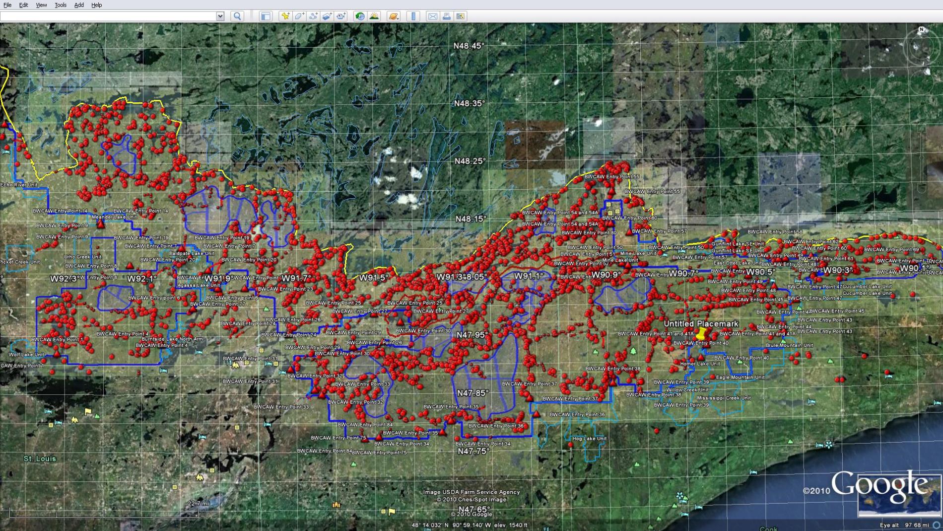
Never before seen KMZ map assembled by hand over a year contains the following:
--complete set of usgs topo overlay tiles generated using gps visualizer. resolution is roughly 1000px per 5km, covering the entirety of the bwca. see sample source overlay here: http://tinyurl.com/2fhou4n
Map also includes:
--USGS lake names, elevation & depth outlines
--complete set of bwcaw campsite waypoints
--complete set of high res bwcaw portage tracks, as well as trail-head waypoints.
--complete set of entry points, each with detailed descriptions.
--High res border tracks
--some low res hiking trails
--neatly organized folders to reduce clutter
see sample screenshots here:
www.polymetric.net/bwcawss1.jpg
www.polymetric.net/bwcawss2.jpg
www.polymetric.net/bwcawss3.jpg
www.polymetric.net/bwcawss4.jpg
Get the map here:
www.polymetric.net/bwcaw_v0.1.1.kmz
tips for use:
--there are folders named 'usgs topo' and 'usgs topo 60%,' you only need one turned on. the 60% one is set to 60% opacity, so you can see the areal imagery beneath the tiles (see screenshots). If you prefer the traditional mckenzie look, just use the "usgs topo" one instead.
--for best terrain effect change "Elevation Exageration" to "3" in google earth settings.
--each time you load the usgs topo maps the data is downloaded from terraservice.net* and they may be slow to load, ive broken them into East, Central and West sub-folders. to save loading time only turn on what you need.
--if an overlay tile doesnt load or shows a big red X, right click on that image and "refresh"
* if you want to write a script to turn the terraservice.net urls into a set of jpegs sourced locally, that'd be great.. plz let me know. until that happens, were stuck downloading the tiles each time.
Its largely incomplete as far as polish, but its good enough that Ive been using it to plan trips for about 2 yrs now, and saved literally dozens of dollars not buying maps. the waypoints and tracks in most cases are good enough for government work, and haven't gotten me lost yet. For the sites ive been to personally ive cleaned them up a bit, but they're sourced from some random site, so no promises of accuracy and no warranties against death if you use this map and get lost, injured, or anything else. :D
Comments?
sample overlay tile
screenshot1
screenshot2
screenshot3
screenshot4
Full Version of the map (89MB)
http://www.polymetric.net/bwcaw_maps_v0.1.2.kmz
Here is the original "Lite" version (413KB, tiles downloaded each time you run google earth):
http://www.polymetric.net/bwcaw_lite_v0.1.2.kmz
Full Version of the map (89MB)
http://www.polymetric.net/bwcaw_maps_v0.1.2.kmz
Here is the original "Lite" version (413KB, tiles downloaded each time you run google earth):
http://www.polymetric.net/bwcaw_lite_v0.1.2.kmz
Original Post:
Never before seen KMZ map assembled by hand over a year contains the following:
--complete set of usgs topo overlay tiles generated using gps visualizer. resolution is roughly 1000px per 5km, covering the entirety of the bwca. see sample source overlay here: http://tinyurl.com/2fhou4n
Map also includes:
--USGS lake names, elevation & depth outlines
--complete set of bwcaw campsite waypoints
--complete set of high res bwcaw portage tracks, as well as trail-head waypoints.
--complete set of entry points, each with detailed descriptions.
--High res border tracks
--some low res hiking trails
--neatly organized folders to reduce clutter
see sample screenshots here:
www.polymetric.net/bwcawss1.jpg
www.polymetric.net/bwcawss2.jpg
www.polymetric.net/bwcawss3.jpg
www.polymetric.net/bwcawss4.jpg
Get the map here:
www.polymetric.net/bwcaw_v0.1.1.kmz
tips for use:
--there are folders named 'usgs topo' and 'usgs topo 60%,' you only need one turned on. the 60% one is set to 60% opacity, so you can see the areal imagery beneath the tiles (see screenshots). If you prefer the traditional mckenzie look, just use the "usgs topo" one instead.
--for best terrain effect change "Elevation Exageration" to "3" in google earth settings.
--each time you load the usgs topo maps the data is downloaded from terraservice.net* and they may be slow to load, ive broken them into East, Central and West sub-folders. to save loading time only turn on what you need.
--if an overlay tile doesnt load or shows a big red X, right click on that image and "refresh"
* if you want to write a script to turn the terraservice.net urls into a set of jpegs sourced locally, that'd be great.. plz let me know. until that happens, were stuck downloading the tiles each time.
Its largely incomplete as far as polish, but its good enough that Ive been using it to plan trips for about 2 yrs now, and saved literally dozens of dollars not buying maps. the waypoints and tracks in most cases are good enough for government work, and haven't gotten me lost yet. For the sites ive been to personally ive cleaned them up a bit, but they're sourced from some random site, so no promises of accuracy and no warranties against death if you use this map and get lost, injured, or anything else. :D
Comments?
sample overlay tile
screenshot1
screenshot2
screenshot3
screenshot4
Full Version of the map (89MB)
http://www.polymetric.net/bwcaw_maps_v0.1.2.kmz
Here is the original "Lite" version (413KB, tiles downloaded each time you run google earth):
http://www.polymetric.net/bwcaw_lite_v0.1.2.kmz

12/02/2010 08:51AM
Ok, now having looked at it a bit, THANK YOU! I have started planning trips using Google Earth and this KMZ is GOLD! Thank you again.
"It is more important to live for the possibilities that lie ahead than to die in despair over what has been lost." -Barry Lopez
12/02/2010 08:58AM
We made our first journey in the bwca last summer. For someone not familiar with the area, this map is fantastic! You can look at all the areas in such detail. Thanks for putting this together!
"If dogs don't go to heaven then when I die I want to go where they are" Will Rogers
")

12/02/2010 12:22PM
Thanks slackard, I use Google Earth for mapping and planning a lot!
Some other mapping programs I indulge in;
 Delorme Topo 9
 Maptech Terrain Navigator
There is a lot that can be done with software mapping, and a variety of resources online and off.
butthead
Some other mapping programs I indulge in;
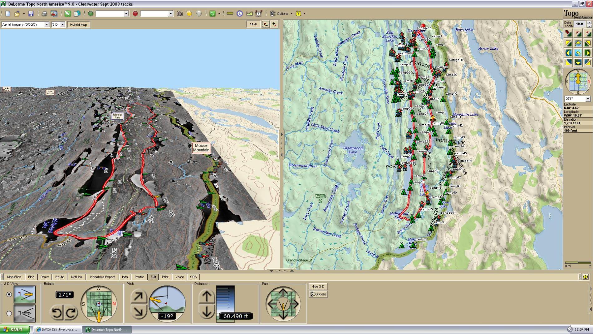 Delorme Topo 9
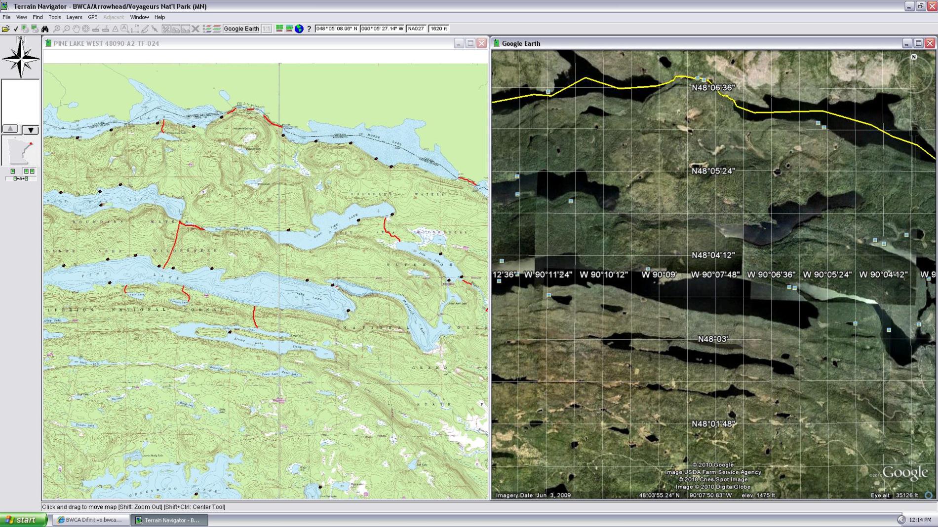 Maptech Terrain Navigator
There is a lot that can be done with software mapping, and a variety of resources online and off.
butthead
"never underestimate the power of stupid people in large groups" George Carlin
12/02/2010 02:27PM
yea, there are a lot of waypoints to draw, and all the overlay tiles add up to about 85mb worth of jpegs. A modern system will handle it pretty ok, but if youre on an atom netbook or older PC, this map will slow things to a crawl.
for those with systems not up to spec, try loading the kmz through the google maps webpage instead, you may see a modest performance increase
Follow this url to view the kmz in google maps:
http://tinyurl.com/2eh36ho
its not quite as easy to use in the google maps webpage, and the usgs topo overlays dont show up, but you can use the google maps terrain/aireal settings instead.
also, at high zoom in google maps the waypoints will appear a little offset to the north.. no idea why, the coordinates for each waypoint are unchanged. just something to be aware of.
Good luck
12/02/2010 04:15PM
no idea why the file extension would change or why a mac wouldnt work. sounds like client side issues to me, but could be related to how this site hands off the urls...
my apache logs show several mac users accessing the links with both safari and firefox.
try copying and pasting
http://www.polymetric.net/bwcaw_v0.1.1.kmz
into your address bar, rather than clicking the link
as for files renamed to .man.. no idea.. if the file is complete and 549kb in size, try just renaming it back to .kmz and opening it in google earth..
cant promise this map will work for everyone
any other mac users out there having trouble andor success?
12/02/2010 04:42PM
quote slackard: "no idea why the file extension would change or why a mac wouldnt work. sounds like client side issues to me, but could be related to how this site hands off the urls...
my apache logs show several mac users accessing the links with both safari and firefox. try copying and pasting
http://www.polymetric.net/bwcaw_v0.1.kmz
into your address bar, rather than clicking the link
as for files renamed to .man.. no idea.. if the file is complete and 549kb in size, try just renaming it back to .kmz and opening it in google earth..
cant promise this map will work for everyone
any other mac users out there having trouble andor success?"
"Sounds client side", I like that. Calling me the idiot that I may very well be and making me smile. That is what I believe they call tact.
12/02/2010 05:54PM
gbusk, if i truly thought it was your fault i'd've said PEBKAC (Problem Exists Between Keyboard And Chair)
I actually blame apple for 'thinking different', and going against the grain over long established norms in cross platform computing!
Damn those damn dirty resource forks!
Damn them to hell!
I actually blame apple for 'thinking different', and going against the grain over long established norms in cross platform computing!
Damn those damn dirty resource forks!
Damn them to hell!
12/02/2010 06:21PM
as i said in the initial post, if tiles dont load or give the red X, find the problem tile(s) in the layers list under the "usgs topo" or "usgs topo 60%" folders by turning each tile on and off individually. once you find your offending tiles, right click and "Refresh"
sometimes i have trouble with a few tiles here and there too.. the problem is the terraservice.net servers may not be responding quickly enough, and google earth times out assuming the link is broken. if a lot of people were using my kmz at once i could see it giving the terraservice.net admins a headache ;)
side notes..
as i said before as well, someone could write a script to capture, rename and update the jpeg overlay tiles in the kmz so they are sourced locally. however this kind of thing is not my expertise, and tho ive done a few by hand, there are a lot of tiles, and it would take me more time by hand than it would take someone else to write a script ;)
also, including the jpgs would greatly increase the size of the kmz itself, making it much less accessible since i cant afford to have dozens of ppl (or more) downloading hundreds of megs each from my wussy little web server.. the 500kb kmz im hosting now is no problem.. thus far, around 100 hits since i started this thread.

12/02/2010 07:22PM
The jpgs themselves are still served up by terraservice.net. i used this form at GPSVisualizer.com (and some math) to generate each tile:
http://www.gpsvisualizer.com/kml_overlay
The usgs tile urls in the kmz I'm providing are up to date at the time of this post and do point to terraservice.net.
e.g. http://tinyurl.com/2fhou4n
if you get the Red X, find that tile in the layers dialogue, and "refresh".
Glad to hear ppl are liking it
http://www.gpsvisualizer.com/kml_overlay
The usgs tile urls in the kmz I'm providing are up to date at the time of this post and do point to terraservice.net.
e.g. http://tinyurl.com/2fhou4n
if you get the Red X, find that tile in the layers dialogue, and "refresh".
Glad to hear ppl are liking it
12/02/2010 07:46PM
Side note.
if you have a newer garmin GPS like the 62, colorado, dakota, or oregon, and visit Brule Lake, check out my giant resolution Brule Lake Custom Map here:
https://forums.garmin.com/showthread.php?t=11418
the map consists of about 36 1000x1000px tiles covering nearly all of Brule and its nearest neighbors, stretching about 9 miles wide by 4 tall.
Plenty of info at the garmin forum for loading this and other custom maps on your garmin.
12/02/2010 09:31PM
quote slackard: "no idea why the file extension would change or why a mac wouldnt work. sounds like client side issues to me, but could be related to how this site hands off the urls...
my apache logs show several mac users accessing the links with both safari and firefox.
try copying and pasting
http://www.polymetric.net/bwcaw_v0.1.kmz
into your address bar, rather than clicking the link
as for files renamed to .man.. no idea.. if the file is complete and 549kb in size, try just renaming it back to .kmz and opening it in google earth..
cant promise this map will work for everyone
any other mac users out there having trouble andor success?"
Mac user here...I would like to download this but no luck.
"So many lakes, so little time." WWJD
12/02/2010 09:39PM
i can only assume the mac browsers mime types are trying to open the kmz file with something other than google earth.
try Control-clicking on this link, then select "save as", and chose a location like your desktop to save the file.
http://www.polymetric.net/bwcaw_v0.1.1.kmz (control-click and save as)
then open google earth and choose file -> open and choose the file you saved.
we have a mac at work, and i can test this tomorrow.
12/03/2010 01:34PM
mac os issues CONFIRMED. if you simply click once on the kmz link safari will open a blank page.
with safari 5.0.3 on 10.5.8 i was only able to access the kmz by Control-Clicking and choosing "Download Linked File As..."
Once saved locally, the kmz can be opened from within google earth by choosing File -> Open.
what we call "client side" :D
with safari 5.0.3 on 10.5.8 i was only able to access the kmz by Control-Clicking and choosing "Download Linked File As..."
Once saved locally, the kmz can be opened from within google earth by choosing File -> Open.
what we call "client side" :D
12/03/2010 02:04PM
I tried this on one of my Macs running windows. when the file is wanting to be saved, and is asking you to choose the location you want to save it in. after you choose the save location change the save as file type from .Man document to ALL FILES, then rename file from "bwcaw_v0.1" to "bwcaw_v0.1.kmz" and save it. :) should load into google earth then.
very nice work on the map overlay, thanks!
very nice work on the map overlay, thanks!
12/06/2010 09:31PM
quote PJ: "This is awesome.
How come only the lake names appear in the 60%/East Folder. Under all the other folders it just says "USGS topo map from GPSVisualizer.com"?"
because even with a script this can not be automated. The lake names that are in there were entered by hand, one at a time by looking at the image, choosing the largest lake on that tile and typing it in manually..
a script could automate migrating the names I have entered from the 60% opaque folders to the other, but the rest that remain completely unnamed would need to be entered by hand. Even tho the tile isnt named, the image itself still shows the lake names in the map image.
originally i had planed to flesh this map out a lot more before i released it, but haven't worked on it in a good while and have many other things happening , so I decided to release it as is. hence version 0.1 instead of 1.0.
If I ever get around to improving the map ill update this post and increment the version.
if anyone has the ambition help name the tiles andor automate any of this i welcome it. Like I said, it lacks polish, but is plenty useful as is.
12/09/2010 04:43PM
Update to v0.11 pending.
In a separate thread Eglath posted a PDF containing bitmaps for each of the Primitive Management Areas (PMA). Ive started work on overlaying these bitmaps in Google earth and outlining each of the PMAs.
Ive got 6 of them done thus far and will update this post with the new KMZ version once its complete.
Screenshot of Weeny Lake PMA here:
12/09/2010 09:41PM
The difference is that with this map you can look at the entire bwca all at once, then zoom into any part of the map for highly detailed satellite images that are simply not available from fisher or mckinzie. Take a look at the screen shots in the first post of this thread for examples.
I've taken the benefits of the mckinzie/fisher maps' topographic and lake depth data (originally sourced from usgs survey data i used), and combined them with the high quality satellite images provided in Google Earth for a unique bwca trip planning experience.... And all for free.
Is this map necessary for trip planning?
No.
Is it handy?
Absolutely.
sidenote: will be working on the PMAs tomorrow and sunday. I'll update this post and all the links within once I've finished the updated version.
12/09/2010 10:02PM
TMI can really ruin a trip. im not saying some level of information cant be helpful, im saying its possible to spend so much time on research that, when you actually get there, youve already "been there"...and you have lost the excitement of discovery. i dont want to be a robot following waypoints...thats just me.
12/09/2010 10:07PM
9 times out of 10 I end up taking something other than my planned route, but then using this map I usually plan 9 or 10 possible routes for each entry anyway.. ;)
As I said tho, no one should rely on this map.. its a reference only kind of thing that BWCA going Google Earth users will enjoy.
As I said tho, no one should rely on this map.. its a reference only kind of thing that BWCA going Google Earth users will enjoy.
12/09/2010 10:19PM
agreed. for those that like this kinda thing, more power to them. it just isnt "me". i just need a paper map...ok, and the pcd database. :)
i hope you understand what i meant by my previous post. not unlike reading the route books cover to cover, over and over...which ive done. soured me alot concerning the bw....
i hope you understand what i meant by my previous post. not unlike reading the route books cover to cover, over and over...which ive done. soured me alot concerning the bw....
12/09/2010 10:30PM
I love maps for maps sake alone... Cool stuff!
That said, I can relate kanoes... like knowing there is a 5 star campsite on a lake you're on, but it's taken is way worse than not knowing it's there at all and being happy with your site. Or something like that. I've never found enough stuff in guide books to be disappointed in the real thing, but there is definitely a different flavor to tripping in an area where you do not know what to expect next.
That said, I can relate kanoes... like knowing there is a 5 star campsite on a lake you're on, but it's taken is way worse than not knowing it's there at all and being happy with your site. Or something like that. I've never found enough stuff in guide books to be disappointed in the real thing, but there is definitely a different flavor to tripping in an area where you do not know what to expect next.
Wherever there is a channel for water, there is a road for the canoe. -Thoreau
12/09/2010 10:39PM
Ok! I get it now. You are obviously technology talented and I am to put it lightly technology challeneged.
While I agree with Kanoes, that too much info has cheapened the BW for me, it wasn't the fault of the info. Just my appetite for it. Hopefully many people will find this a valuable tool. Thanks for the nice explanation you gave me but I will stick with my old fisher.
While I agree with Kanoes, that too much info has cheapened the BW for me, it wasn't the fault of the info. Just my appetite for it. Hopefully many people will find this a valuable tool. Thanks for the nice explanation you gave me but I will stick with my old fisher.
12/10/2010 10:01AM
While I do use tech info for planning trips, I spend much more time looking at where I have been and traveled. Looking at a track profile [distance and height, graphed] does not influence my planning much, it means much more to me after I have been there.
Maps can be and are more than just planning tools, both old Fisher Maps and the latest map software.
butthead
Maps can be and are more than just planning tools, both old Fisher Maps and the latest map software.
butthead
"never underestimate the power of stupid people in large groups" George Carlin
12/10/2010 11:15AM
TMI is no in my vocabulary when researching a PMA, but yeah, on other stuff it can be overkill. Guess we all just have to learn when to say when, huh? But knowledge = POWER lol. it's a tough one to dismiss at times!
Awesome stuff here. I'm gonna drop you an email Slackard, it'll be self-explanatory.
Awesome stuff here. I'm gonna drop you an email Slackard, it'll be self-explanatory.
Trust, but verify. The Lord will provide !!!!

12/15/2010 07:23AM
quote slackard: "As promised, I've added the PMA zones to the map. Download the updated version here:
http://www.polymetric.net/bwcaw_v0.1.1.kmz
(Remember Mac users, control click and "download linked as...")"
This is an awesome tool to have. Thanks so much for constructing this.
"It is more important to live for the possibilities that lie ahead than to die in despair over what has been lost." -Barry Lopez
12/15/2010 09:32AM
WOW,BEYOND MY ABILITY
Heh!
if "save as" and "file -> open" are too much to handle, you've got no business using a computer let alone this map :P
Plenty of notes in earlier posts on how to get this thing rolling.
If you have a specific issue, drop a note here and i'll try to address.
06/17/2011 08:35AM
UPDATE 6/17/2011
So the USGS topo overlays from the map I originally posted now have out-of-date urls in the image links. Basically what used to be terraservice.net has become msrmaps.com.
I updated my map with the current/correct urls for the image overlays.
In the next couple months ill work on actually storing the images locally and including them in the kmz (doing so will drastically increase file size--178 tiles, at about 500kB each). Having the images stored locally will also reduce the load on the msrmaps website (which they may appreciate, if this map starts to see wider use).
Get the updated version of my map here:
http://www.polymetric.net/bwcaw_v0.1.2.kmz
06/17/2011 09:34AM
Awesome, thanks Slackard! =)
I look forward to the new version with local tiles. Even with a really fast connection it sometimes takes forever for it to fill in.
I look forward to the new version with local tiles. Even with a really fast connection it sometimes takes forever for it to fill in.
When a man is part of his canoe, he is part of all that canoes have ever known. - Sigurd F. Olson, "The Singing Wilderness"
06/17/2011 11:19AM
quote flopnfolds: "Too bad it doesn't have more quetico data ;)
"
This is something I'd like to add.. If someone knows where i can get Quetico campsite & portage trailhead waypoints, andor tracks I'll add them. (I just havent had time to look for this data myself).
The real drawback is the USGS Topo overlays that make this map what it is are not available for Quetico, so a quetico map will never be quite as complete as the US side of the boarder..
We could buy the Fisker/McKinsey maps, scan them on the wide scanner at kinkos, then overlay the scanned images in Google Earth. This is very doable, but wide scans run about 12$ each + the price of the maps, not to mention it would be very time consuming. (we could do this for the US side too, but the usgs data is plendy good IMO)
If there is serious interest I'll set up a Donate button in the next map release and we'll see if we can get enough interest (and donations) to actually get Quetico Topo mapped in Google earth.
06/17/2011 11:59AM
quote slackard: "UPDATE 6/17/2011
So the USGS topo overlays from the map I originally posted now have out-of-date urls in the image links. Basically what used to be terraservice.net has become msrmaps.com.
I updated my map with the current/correct urls for the image overlays.
In the next couple months ill work on actually storing the images locally and including them in the kmz (doing so will drastically increase file size--178 tiles, at about 500kB each). Having the images stored locally will also reduce the load on the msrmaps website (which they may appreciate, if this map starts to see wider use).
Get the updated version of my map here:
http://www.polymetric.net/bwcaw_v0.1.2.kmz "
Oh my. This will serve as my fix for the BW in the winter while planning my trips.
Good work.
"In wilderness is the salvation of mankind." Thoreau.
06/17/2011 01:37PM
quote Thaumaturgist: "I've downloaded, and linked all of the individual maps, but the file is quite huge (100 Megs). If you know of a place where it can be hosted, I'll be glad to put it up somewhere."
did you do this manually? too much effort for me!! ive started the manual process in the past, but never got very far.. Creating the tiles in the first place probly took even longer (prly why im not too motivated)
I can toss up a hosted copy if you send it to me. Hit me with and email or a private message and i can get you an upload account to push me the files (not for public discussion)
06/17/2011 04:00PM
"
Thanks to Thumaturgist's effort we will soon have a "full" version and "lite" version of the BWCAW map.
The FULL version will be around 100mB and will contain ALL the USGS Topo images in the download. This will allow you to view the map (and image overlays) without having to download each tile every time you start GEarth.
The LITE version will be around 1.5mB and is identical to the currently available map (v0.1.2), simply renamed LITE. Topo images are downloaded on the fly whenever the overlay is enabled.
Thuamaturgist hasnt sent me the image tiles yet, but he has the login info he needs, so i should be able to make the FULL and LITE versions available soon.
quote Thaumaturgist: "I've downloaded, and linked all of the individual maps, but the file is quite huge (100 Megs). If you know of a place where it can be hosted, I'll be glad to put it up somewhere."
Thanks to Thumaturgist's effort we will soon have a "full" version and "lite" version of the BWCAW map.
The FULL version will be around 100mB and will contain ALL the USGS Topo images in the download. This will allow you to view the map (and image overlays) without having to download each tile every time you start GEarth.
The LITE version will be around 1.5mB and is identical to the currently available map (v0.1.2), simply renamed LITE. Topo images are downloaded on the fly whenever the overlay is enabled.
Thuamaturgist hasnt sent me the image tiles yet, but he has the login info he needs, so i should be able to make the FULL and LITE versions available soon.
06/20/2011 12:49PM
Don't forget in Google Earth if you hold down your scroll wheel on your mouse and move your mouse around you can get yourself some very interesting birds eye views and turn corners and get down to the level of the water or what have you.
There is also a built in flight simulator under 'tools' that you can fly a fighter or a prop plane around your favorite BWCA lakes. Juts in case anyone needed to waste some time. I've been doing some low passes of Vista Lake...pretty cool!
Croixboy
There is also a built in flight simulator under 'tools' that you can fly a fighter or a prop plane around your favorite BWCA lakes. Juts in case anyone needed to waste some time. I've been doing some low passes of Vista Lake...pretty cool!
Croixboy
"Two wrongs don't make a right but three rights make a left." - Ty Webb
06/24/2011 09:18AM
quote Thaumaturgist: "I was able to send the files this morning, so the full version will be here soon."
I received the files Thaum sent me but havent had time to look at them yet. Just got back from a solo trip to Brule--3 straight days of wind andor rain with no sun.. Everyone loves packing/paddling out in the rain! FUN!
When I get a chance I will post updated version and link info for the Full and Lite versions announced last week.
Thanks again to Thaumaturgist for his work handling the USGS Topo tiles.
06/25/2011 07:48AM
quote kanoes: "TMI can really ruin a trip. im not saying some level of information cant be helpful, im saying its possible to spend so much time on research that, when you actually get there, youve already "been there"...and you have lost the excitement of discovery. i dont want to be a robot following waypoints...thats just me."
I see what you're saying Jan. However I must have went over your trip report for the Frost River loop about a dozen times. One of my favorite parts of the trip was rediscovering those crazy mushrooms that were growing on the side of the tree. I saw the pictures of them in your trip report so for me it was really great to see them up there.
It was almost like an old portage that I had been on several times before.
Just a fun memory... thought I'd share.
06/25/2011 01:20PM
quote tremolo: "I think my Mac is too old. I cannot open any of the links. The first set of images, I can see, and it looks fantastic, esp for a navigationally challenged person such as myself. "
A mac that can run Google Earth can use this map.
First, the mime types for KMZ files are not always handled well by Safari/OSX, try Firefox andor try Control-Clicking on the link and choosing "save linked file as"
2nd, you need google earth installed. (once the map is saved to your local system, open google earth and choose File -> Open, then browse to the KMZ file you downloaded.
Make sure you scroll through the threads to find the latest version of the link, some of the original links have outdated info.
New versions/links are immanent within the next week or so.
07/06/2011 03:06PM
Thanks for the vast amount of work.
Awesome.
I'm heading out for a trip tomorrow.
A map is no substitute for a trip, but its great for planning.
In the winter this will keep a restless soul somewhat happy.
In addition to the panoramio photos Google Earth has as a native layer, you can add this http://flickr-photos-in-ge.appspot.com/flickr-photos-in-google-earth.kmz to add geotagged flickr photographs.
Then sit back and take a trip while the wind and snow howl outside.
07/06/2011 03:55PM
The Flickr thing I am finding AWESOME!! I use Flickr (who uses that Panorama that Google Earth defaults to?) and have always geotagged my photos in the BWCA and some of my photos are showing up in Google Earth now. Plus, it's cool to see other people's photos of the same area in another time. Thanks for the Flickr tip and link!
Croixboy
Leave in 11 days.
Croixboy
Leave in 11 days.
"Two wrongs don't make a right but three rights make a left." - Ty Webb
07/07/2011 08:42AM
quote slackard: "This is something I'd like to add.. If someone knows where i can get Quetico campsite & portage trailhead waypoints, andor tracks I'll add them. (I just havent had time to look for this data myself)."
You could use the PCD files. There are files for both campsites and portages. I don't think you need permission to use it for noncommercial use.
07/07/2011 11:19AM
Has anyone mention you can get a kmz file to display topo maps in Google earth?
http://www.knowthenetwork.com/2008/07/google-earth-topo-maps/
actual link for the file
http://www.gearthblog.com/kmfiles/topomaps.kmz
(for windows users)
paste the link in your browsers address space, hit enter then when its retrieved you should get a dialog asking whether you wish to open with google earth, say yes or click the open button.
you can also retrieve the file by going to the first url above and right clicking on the link 'USGS Topo Map Layer'
When Google earth opens
Save the file to your permanent places and you can toggle a topo layer on and off.
09/06/2011 12:09AM
ok so i lost track of time and forgot to update these links.
We now have my full BWCA map with high res image tiles included in the download. This file is 89MB in size and will take a long time to download from my 5mbit connection, but you will only have to download it once. No more waiting for tiles to load every time you start google earth.
I will leave this file up as long as it doesn't become a nuisance with lots of people downloading, killing my connection.
here is the link to the Full Version of the map (89MB)
http://www.polymetric.net/bwcaw_maps_v0.1.2.kmz
Here is the original Lite version (413KB, tiles downloaded each time you run google earth):
http://www.polymetric.net/bwcaw_lite_v0.1.2.kmz
let me know if you have trouble.
09/06/2011 12:25AM
quote Ken: "Has anyone mention you can get a kmz file to display topo maps in Google earth?
http://www.knowthenetwork.com/2008/07/google-earth-topo-maps/
actual link for the file
http://www.gearthblog.com/kmfiles/topomaps.kmz
(for windows users)
paste the link in your browsers address space, hit enter then when its retrieved you should get a dialog asking whether you wish to open with google earth, say yes or click the open button.
you can also retrieve the file by going to the first url above and right clicking on the link 'USGS Topo Map Layer'
When Google earth opens
Save the file to your permanent places and you can toggle a topo layer on and off."
Hay, thanks!
The topo map you link to is handy but the drawback of having to wait for the tiles to download again and again is still an issue here.. actually this kmz is downloading new data every time i zoom, not just when i first activate the map. :(
Also I dont see a way to reduce the opacity of the maps you linked us to either.. Personally I prefer to see the topo overlay at about 60% opacity so I can see the google imagery but still make out the topo lines. Not sure what others prefer... any ideas for reducing opacity?
thanks again for the neat kmz link.
04/10/2012 12:50PM
I love this thread and greatly appreciate the hard work & effort that has gone into this. It has been quite a while since it was put together and looking it over it appears there are multiple *UPDATES* that have been added along the way.
Here's hoping someone that is "in-the-know" could provide a consolidated summary for those that have not yet found this (but will now thanks to the bump).
Here's hoping someone that is "in-the-know" could provide a consolidated summary for those that have not yet found this (but will now thanks to the bump).
There is no Sin greater than Ignorance. ~ Rudyard Kipling
04/17/2012 07:29PM
quote slackard: "here is the link to the Full Version of the map (89MB)
http://www.polymetric.net/bwcaw_maps_v0.1.2.kmz
Here is the original Lite version (413KB, tiles downloaded each time you run google earth):
http://www.polymetric.net/bwcaw_lite_v0.1.2.kmz
let me know if you have trouble."
Hey, slackard... you still hanging around?
As part of re-constructing my data on a new iMac after a crash (ALMOST had everything on the old one backed up...) I downloaded the Full Version of v0.1.2, above. When viewing it in Google Earth is shows in My Places as bwcaw Maps v0.1.1.kmz.
Still amazing work, but I wonder if I am missing out on some updated stuff. Thanks again for this.
"You can observe a lot just by watching." -- Yogi Berra
06/08/2012 07:44AM
quote schweady: "quote slackard: "here is the link to the Full Version of the map (89MB)
http://www.polymetric.net/bwcaw_maps_v0.1.2.kmz
Here is the original Lite version (413KB, tiles downloaded each time you run google earth):
http://www.polymetric.net/bwcaw_lite_v0.1.2.kmz
let me know if you have trouble."
Hey, slackard... you still hanging around?
As part of re-constructing my data on a new iMac after a crash (ALMOST had everything on the old one backed up...) I downloaded the Full Version of v0.1.2, above. When viewing it in Google Earth is shows in My Places as bwcaw Maps v0.1.1.kmz.
Still amazing work, but I wonder if I am missing out on some updated stuff. Thanks again for this.
"
I think i was just lazy here and forgot to rename the folder inside the KMZ.. If you hit one of the 0.1.2 links, you've got the latest version. Also just updated the original post with the up-to-date links there too for new-comers.
06/30/2012 03:41PM
Unfortunately i dont have any good data for the Quetico portages or campsites.
There may be a few tracks or waypoints in the data i used that spill over the Canadian border, but largely Quetico data is not included. If anyone knows a good source for GPS/GPX data for Quetico, I would include it in my map as long as the data free for non-commercial use.
There may be a few tracks or waypoints in the data i used that spill over the Canadian border, but largely Quetico data is not included. If anyone knows a good source for GPS/GPX data for Quetico, I would include it in my map as long as the data free for non-commercial use.
03/13/2013 01:12PM
quote sege5641: "This thread NEEDS to be pinned to the top! I had no idea that I could download this map. I had to do a search to find it."
Yea, not sure who to talk to about getting this pinned for higher visibility -- would be useful for anyone interested in trip planning.
Is there a moderator among us willing to do this?
Thanks in advance!
BTW: here are the latest versions of the KMZ, so people dont have to scroll around for them.
BWCAW Lite Version (415kbytes)
BWCAW Full Version (91mbytes)
03/13/2013 04:33PM
quote TuscaroraBorealis: "quote slackard: "Yea, not sure who to talk to about getting this pinned for higher visibility
"
Your best bet would be to e-mail Adam directly. Contact "
Have followed through on this lead. Thanks!
Hopefully we see some action.
04/01/2013 06:10PM
In honor of today's April fools Treasure map in maps.google.com, I created v0.1.3 of the definitive BWCA map which includes an overlay layer with google's treasure map. This adds about 30mb to the total size, and is simply a novelty, but still neat looking. Enjoy!

Download the v0.1.3 map here (Includes Treasure Map Overlay, 120mb)
http://www.polymetric.net/bwcaw_maps_v0.1.3.kmz
Download the v0.1.2 map here (Includes USGS TOPO overlay only, 85mb)
http://www.polymetric.net/bwcaw_maps_v0.1.2.kmz
Download the v0.1.2 map here (Lite version, 450kb)
http://www.polymetric.net/bwcaw_lite_v0.1.2.kmz
06/20/2013 11:06PM
FYI: the lite version works on my android smartphone with Google Earth app. (But not the full version.) Be sure to download the file, not just "open with" google earth.

And here is what it looks like without a data connection:

To use google earth offline, look at your areas with a data connection (zoomed in), then exit GE. The data will be saved in cache. (In settings you can adjust the size of cache.) You can still use the GPS without a data connection. Then open your downloads and select the file to pull it up again in GE. Just remember to not use GE after saving your desired area to cache or you might overwrite it with newer data.
I can still see campsites that i saved to screenshot:
Otherwise here is a great external power for electronics link

And here is what it looks like without a data connection:

To use google earth offline, look at your areas with a data connection (zoomed in), then exit GE. The data will be saved in cache. (In settings you can adjust the size of cache.) You can still use the GPS without a data connection. Then open your downloads and select the file to pull it up again in GE. Just remember to not use GE after saving your desired area to cache or you might overwrite it with newer data.
I can still see campsites that i saved to screenshot:

Otherwise here is a great external power for electronics link
09/27/2013 11:21AM
I can't thank you enough for this map! It is priceless for the novice and experienced alike. I constantly find myself exploring different lakes and trip planning (even though I'm not trip planning) over my lunch break.
I also use Bing Maps after a discovery on your Google Earth app because of it's great clarity.
THANK YOU!!
I also use Bing Maps after a discovery on your Google Earth app because of it's great clarity.
THANK YOU!!
01/05/2018 10:58PM
scoobe421: "I had this overlay and it is great. Bad news is my computer files got corrupted. Anyone have one to share? Seems these links are broken."
Email sent.
"Leave it as it is.....The ages have been at work on it and man can only mar it." Theodore Roosevelt
02/06/2019 08:26AM
WonderMonkey: "Dang. Is getting an email to use this a limited amount of people. If not I'd appreciate an email or a link."
Same here, if someone has the full version I'd love to get an email! You can always use wetransfer.com for files that are too large to attach.
02/06/2019 09:02AM
cyclones30: "WonderMonkey: "Dang. Is getting an email to use this a limited amount of people. If not I'd appreciate an email or a link."
Same here, if someone has the full version I'd love to get an email! You can always use wetransfer.com for files that are too large to attach. "
I'm temporarily sharing that file from my Google Drive. I sent Swascelot the link in an email because I worried a bit about overload with a link here. But, I'll give it a try...
bwcaw_maps_v0.1.3.kmz
(At the 'Whoops!' page, click 'Download file.' At the "Can't scan this file for viruses," message, click 'Download anyway.')
"You can observe a lot just by watching." -- Yogi Berra
02/06/2019 11:53AM
schweady: "cyclones30: "WonderMonkey: "Dang. Is getting an email to use this a limited amount of people. If not I'd appreciate an email or a link."
Same here, if someone has the full version I'd love to get an email! You can always use wetransfer.com for files that are too large to attach. "
I'm temporarily sharing that file from my Google Drive. I sent Swascelot the link in an email because I worried a bit about overload with a link here. But, I'll give it a try...
bwcaw_maps_v0.1.3.kmz
(At the 'Whoops!' page, click 'Download file.' At the "Can't scan this file for viruses," message, click 'Download anyway.')
"
I appreciate it! I downloaded it and will give it a go this evening.
02/07/2019 09:33AM
schweady:
I'm temporarily sharing that file from my Google Drive. I sent Swascelot the link in an email because I worried a bit about overload with a link here. But, I'll give it a try...
bwcaw_maps_v0.1.3.kmz
(At the 'Whoops!' page, click 'Download file.' At the "Can't scan this file for viruses," message, click 'Download anyway.')
"
Thanks for sharing this! It worked fine here.
02/07/2019 10:33AM
Everything worked fine with the exception of red X's for campsites and portages. That's easily taken care of. I did notice Quetico wasn't as far along as BWCAW, but still much appreciated. I can add Quetico on my own if it's not already done.
02/07/2019 02:22PM
WonderMonkey: "Everything worked fine with the exception of red X's for campsites and portages. That's easily taken care of. I did notice Quetico wasn't as far along as BWCAW, but still much appreciated. I can add Quetico on my own if it's not already done."
Yeah, it's been ages since I've even looked at this. Just have it tucked away in my Google Earth app. So many other sources have these USGS topography images that I forget it's here. (But, eight years back, it certainly was the cats!) In Google Earth, I simply uncheck Entry Points, Campsites, and Portages in the bwcaw_maps file and check my mn canoeing.kml file to display EPs and portages and sites etc in both the BW and Q on top of the USGS topo.
"You can observe a lot just by watching." -- Yogi Berra
02/07/2019 08:47PM
schweady: "WonderMonkey: "Everything worked fine with the exception of red X's for campsites and portages. That's easily taken care of. I did notice Quetico wasn't as far along as BWCAW, but still much appreciated. I can add Quetico on my own if it's not already done."
Yeah, it's been ages since I've even looked at this. Just have it tucked away in my Google Earth app. So many other sources have these USGS topography images that I forget it's here. (But, eight years back, it certainly was the cats!) In Google Earth, I simply uncheck Entry Points, Campsites, and Portages in the bwcaw_maps file and check my mn canoeing.kml file to display EPs and portages and sites etc in both the BW and Q on top of the USGS topo.
"
I can throw my paddle blah planner date on top of what you were nice enough to provide and I'm good. I appreciate you making it available.
05/16/2019 08:49AM
WonderMonkey: "Everything worked fine with the exception of red X's for campsites and portages. That's easily taken care of. I did notice Quetico wasn't as far along as BWCAW, but still much appreciated. I can add Quetico on my own if it's not already done."
Care to enlighten me on how to fix those darn red Xs?

03/06/2020 01:24PM
i'm sorry to be reviving an 8 year old thread -- but the below domain is no longer valid nor are there any backups available on the timemachine -- is the below file still in existence somewhere and if so could please someone share it with me?
my idea is to use kmzfactory to break it up into garmin consumable smaller tiles and use it in basecamp/gpsmaps 66.
thanks much for any response.
my idea is to use kmzfactory to break it up into garmin consumable smaller tiles and use it in basecamp/gpsmaps 66.
thanks much for any response.
03/08/2020 07:43AM
iridium7777: "i'm sorry to be reviving an 8 year old thread -- but the below domain is no longer valid nor are there any backups available on the timemachine -- is the below file still in existence somewhere and if so could please someone share it with me?
my idea is to use kmzfactory to break it up into garmin consumable smaller tiles and use it in basecamp/gpsmaps 66.
thanks much for any response.
"
Lol I was trying to open the stuff too and was wondering why it wasn't working. Hope you find someone who has it though.
“Adopt the pace of nature: her secret is patience.” - Ralph Waldo Emerson
03/09/2020 06:43AM
ahh, the link quoted a few posts above for the 0.1.3 version does work but it looks like it was made in jest and it has this obnoxious background layer of trees or something that masks the overlay completely. i'm not sure if there's a way to turn it off or remove it, or if someone has or would be willing to re-post the 0.1.2 version.
anyways, what i've been doing is downloading all of the 2019 USGS 24K quads in KMZ file and have been breaking them up for garmin size limits. i'm about 45% done mapping all of the BW, i'll dump these files on my box drive when i'm done.
it looks something like this:
https://ngmdb.usgs.gov/ht-bin/tv_browse.pl?id=b61ec23bf5a2f1daa0cd168123fd9f24
03/09/2020 10:22AM
When a man is part of his canoe, he is part of all that canoes have ever known. - Sigurd F. Olson, "The Singing Wilderness"

Subscribe to Thread
Become a member of the bwca.com community to subscribe to thread and get email updates when new posts are added. Sign up Here
Community Links
 Search BWCA.com
 Donate
 Featured Sponsor
