|
||||
 Boundary Waters Quetico Forum Quetico Forum Campsites at the north end of Kawnipi lake Reply Boundary Waters Quetico Forum Quetico Forum Campsites at the north end of Kawnipi lake Reply
|
| Previous Messages: | |
| Author | Message Text |
| Gaidin53 |
04/25/2022 09:10AM That would be a good idea to have a pinned post for fire related areas in Quetico. We should all try to take the time after trips to update portage and campsite reviews in those areas and obviously other areas as well. Ryan |
| Argo |
04/25/2022 06:58AMGaidin53: "Keep in mind it doesn’t show severity of burn. Quetico released a map last fall that is around that shows severity of burn. It’s really hard though to look back and forth trying to figure out between maps where things are though. I wish somehow the PP one could show the severity but that would be seriously challenging to do. I've chatted with Jackfish about creating a pinned message where people who travel through these burn sections can post their observations about sites, portages and lakes in general. A bit soon for that now though. |
| Gaidin53 |
04/24/2022 11:12PM Keep in mind it doesn’t show severity of burn. Quetico released a map last fall that is around that shows severity of burn. It’s really hard though to look back and forth trying to figure out between maps where things are though. I wish somehow the PP one could show the severity but that would be seriously challenging to do. I had debated on posting a specific thread on here with that information but since PP is like a taboo subject I decided not to start a whole new thread on that alone. Ryan |
| gravelroad |
04/24/2022 07:13PMGaidin53: "The PP site actually added in the fires from last year into the Quetico map so you can see the outline of where the fire was more accurately when route planning and looking at campsites now. Thanks for pointing this out. It is indeed useful for planning purposes. |
| Gaidin53 |
04/24/2022 04:12PM The PP site actually added in the fires from last year into the Quetico map so you can see the outline of where the fire was more accurately when route planning and looking at campsites now. I’m going through Kawnipi twice. Also planning on going through the Poet chain. I did talk to Quetico earlier this year and they weren’t really concerned about Kawnipi or even Shelly and Montgomery. I’m planning on going through Montgomery then into Kawnipi on my way south. The fire went through the East end of Shelly and the west end of Montgomery. My trip is in July though so more time for portages to get cleaned up by the time I go. They were more worried about the longer portages going from Delahey to Conmee. Ryan |
| gravelroad |
04/24/2022 11:52AM If I were headed to the northern end of Kawnipi, I would want to have a chat with the folks at Quetico and/or the Ontario Ministry of Natural Resources about last year’s fires. Here’s a map from September 1, the most recent I could find and well before the end of the fires. 
|
| Gaidin53 |
04/13/2022 09:06PM I’ve used Navionics on my iPhone in airplane mode for years. I haven’t used the mapping so much with the Garmin Eplore app. I assume it should work just the same and wouldn’t need to be blue toothed and connected to the actual Garmin device. Where I’ve tripped the last few years I had everything entered in a similar way on Navionics. So last year even though I had my own Garmin I didn’t take the time to transfer it over. I have now which is why you also got sent the BWCA stuff. I have the 66i with the Quetico BWCA map chip. Explore app does not show the map chip details. That only shows on my actual Garmin device. In order to send a message I’d obviously have to Bluetooth connect the phone and the Garmin gps. Or send it from the gps. Glad you liked the detail! Your welcome. It was a lot of work but I did enjoy doing it and will reap the reward this summer. Ryan |
| cburton103 |
04/13/2022 07:17PMWaterboy: "Ryan - I've used the Earthmate app connected to my Garmin inReach Mini for several years. As long as your bluetooth is on and you've connected your phone and Garmin inReach, you'll be able to pull up the maps on your phone even while in airplane mode. Never had an issue with it! |
| Waterboy |
04/13/2022 04:40PM Ryan - I just downloaded the gpx files you sent to me yesterday - WOW! Love how you designated the campsite ratings with different colors. This was a great idea and makes it simple to find the top rated campsites along our route. I use a Garmin InReach during our trips but have never used Garmin Explore on my iPad or iPhone to view the maps. This make viewing so much easier to view the maps with the larger screens. I must have been living under a rock not to know about Explore. In doing some reading on Garmin Explore and Earthmate, it looks like you can navigate with an iPhone without connecting to cell or internet service. It would be nice to use the iPhone to navigate with the bigger screen. Can anyone share their experience in navigating with Explore/Earthmate on an iPhone in airplane mode. Thanks again Ryan for all your great work on this! |
| cburton103 |
04/13/2022 08:08AMGaidin53: "Sent! Did anybody actually upload them yet and look at them? Easiest way would be to upload them to the Garmin explore app and then they will sync to the gps. Looking at them on my phone or iPad is way easier as well for scrolling around. I haven’t just yet. Going on a family beach trip next week, and I’ll begin more earnest Quetico preparations in early to mid May. Looking forward to digging through the maps though! Thanks again for sending them! |
| Gaidin53 |
04/12/2022 10:57PM Sent! Did anybody actually upload them yet and look at them? Easiest way would be to upload them to the Garmin explore app and then they will sync to the gps. Looking at them on my phone or iPad is way easier as well for scrolling around. Ryan |
| Waterboy |
04/12/2022 09:00PM I’d love the gpx files as well! Thanks for all the time and effort you put into this! Joe.fleming@comcast.net |
| Gaidin53 |
03/19/2022 09:46PM Sent! I had to do a complete reset of my iPad today at the Apple store so having lots of fun slowly pulling into the apps and signing in again as well as emails. Pretty much everything but what was associated to my iCloud account. That all came over just fine. Ryan |
| deancal20 |
03/19/2022 11:04AM I have a Garmin Inreach as well and camp mostly around Pickerel area. Any maps would be appreciated. deancal20@hotmail.com |
| Gaidin53 |
03/16/2022 06:43PM I’ve got the Garmin BWCA chip in the gps. It won’t show any of that data on anything but the actual gps though. Maybe it’s different if you get the download version. I’ve gone through and placed flags and other items like pictographs, Cliff jumping spots but none of those are perfectly accurate they are placed as close as possible by me. Lots of the campsites in the Q haven’t been rated so I only place marks on ones that have been rated and I trust the rating. Ryan |
| wyopaddler |
03/16/2022 05:23PM Hey Ryan, Which GPS chip do you have exactly? The one from Garmin that has the BWCA and the Quetico? |
| Gaidin53 |
03/16/2022 03:10PM So far 3 people asked and I’ve sent the gpx files. Let me know how things go transferring them over. I most likely need to do some BWCA stuff for a buddy so he has access on his Garmin but haven’t done it yet or check3d to see if he did it when I sent them to him. Also let me know what you think about the detail! I’d love some kudos once you have a clue what I just gave you! Happy to share it though to other serious paddlers! Ryan |
| toothmiester |
03/16/2022 02:51PM Ditto!!!!!!!!! |
| cburton103 |
03/16/2022 02:05PMGaidin53: "Garmin. Those specific screen shots are from the Garmin Explore app on my ipad. I’ve got the BWCA Quetico map chip which has most of the campsites marked. I’ve manually gone through using the gps and added in flag gps points for reviewed campsites and other specifics like pictographs and such. I’ve pretty much done the entire Quetico. I got on a roll and just kept chipping away at areas over last fall and this winter. I have no idea how many hours I spent doing it but it was a lot. I like being prepared and knowing what the best options are when paddling to an area. I then went through and annotated the paper maps as well with the information for my trips this year. *raises hand* I use a Garmin inReach, and I would love that file if you're willing to share! cburton103@yahoo.com |
| Gaidin53 |
03/16/2022 09:19AM Garmin. Those specific screen shots are from the Garmin Explore app on my ipad. I’ve got the BWCA Quetico map chip which has most of the campsites marked. I’ve manually gone through using the gps and added in flag gps points for reviewed campsites and other specifics like pictographs and such. I’ve pretty much done the entire Quetico. I got on a roll and just kept chipping away at areas over last fall and this winter. I have no idea how many hours I spent doing it but it was a lot. I like being prepared and knowing what the best options are when paddling to an area. I then went through and annotated the paper maps as well with the information for my trips this year. If anyone is interested and uses a Garmin I could send the Quetico groupings in an email. You should be able to just pull the groupings into your account. Ryan |
| RodPortage |
03/15/2022 04:32PM Ryan, those are some lovely maps. What did they come from? |
| toothmiester |
03/15/2022 03:50PM Nice trip Ryan, I have not been thru the Man Chain. We are planning our trip for August 17th and plan on fishing walleye and also stopping at some lake trout lakes along the way to Kawnipi. |
| Gaidin53 |
03/15/2022 03:00PM I’m doing the same thing July 3rd. Looping South through Agnes, East through Man Chain and back up Kawnipi. Ryan |
| toothmiester |
03/15/2022 01:58PM I am planning on entering at Stanton Bay on Pickerel Lake. :-) |
| Gaidin53 |
03/15/2022 01:23PM Where are you entering at? If my trip goes as planned I’ll be on Kawnipi lake twice. Ryan |
| toothmiester |
03/15/2022 11:25AM Thank You gaidin, much appreciated!!!! |
| Gaidin53 |
03/15/2022 10:44AM Red flags are 4* 5* campsites Blue is 3* campsites Yellow is 1* 2* campsites These are all based off of PP reviews and also campsites noted in YouTube videos. Ryan 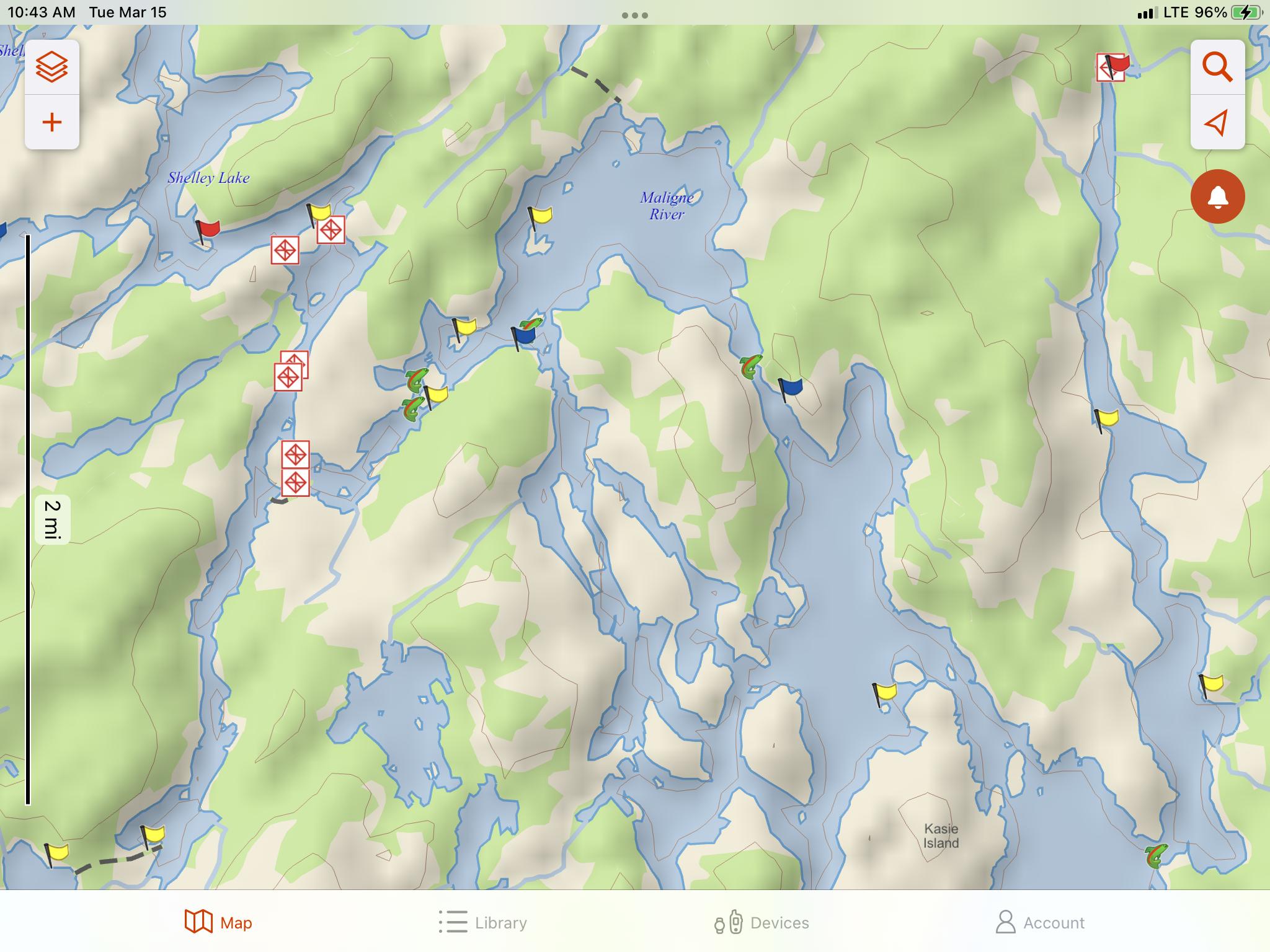  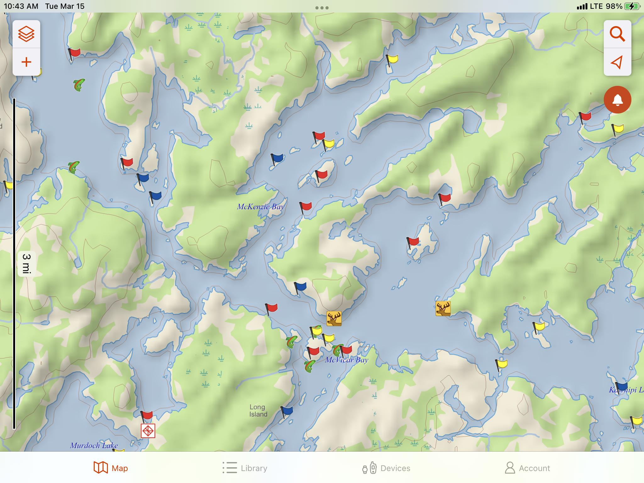
|
| toothmiester |
03/15/2022 09:32AM I am headed into kawnipi lake mid august and wondering if anyone knows of any nice camp site locations near the big water at the north end of kawnipi Lake. |
 Search BWCA.com
 Donate