|
||||
 Boundary Waters Quetico Forum Quetico Forum 2025 Quetico Trip - Agnes, Kawnipi, Camel, Hoare, Kahshahapiwi Reply Boundary Waters Quetico Forum Quetico Forum 2025 Quetico Trip - Agnes, Kawnipi, Camel, Hoare, Kahshahapiwi Reply
|
| Previous Messages: | |
| Author | Message Text |
| Fingolfin |
10/05/2023 07:39PMMinnesotian: " Thanks for this! I’m expecting the way in to be a challenge, but based on the fire map it looks like the northern shore of Hoare didn’t get the worst of it, so hoping the island is also mostly unscathed. I haven’t seen any reports from anyone on Hoare since the fire, but I’m hoping there’s still a message jar my group can add our names to. |
| Minnesotian |
10/05/2023 08:51AM Did basically the route you are describing back in 2017 as a solo trip, including staying on Camel and bushwhacking into Hoare. I found the route to Hoare pretty decent, with just a hint of a faint path and a couple of cut logs along the way as something to confirm the route, but not rely on. After the fire though? I would plan on doubling any time you are estimating. And once you get to Hoare you may find you'll have to carve out a place on the island to set up, if it got burnt up. |
| sns |
10/02/2023 10:24PM Sounds like a great type 2 adventure. I just exited Quetico today....and did a bushwhack on my solo trip. Normally I single carry. Bushwhacking it depends...I did find a spot or two where I could single. Mostly it was pack first while pathfinding for 50, 100, 150 meters, then drop & back for the canoe, and leapfrogging that way forward. And the few times where I found myself in a tangle where I was certainly the first member of our species stupid enough to attempt passage, I would pathfind with no load first, and then retreat to bring each load forward. |
| Fingolfin |
10/02/2023 03:29PMtumblehome: "I double portage all the time. Hypothetically, if I portage off of Camel to Hoare, I left non-essentials back at camel and only took what was needed for the night on Hoare. That's hypothetical of course lol. Seems like a solid plan, and Camel seems remote enough that I wouldn’t expect a run on campsites. I was thinking a couple nights on Hoare to allow a full day on the lake for fishing and exploration, assuming basically a full day in and close to a full day out. |
| Stumpy |
10/02/2023 02:13PMtumblehome: "I double portage all the time. Hypothetically, if I portage off of Camel to Hoare, I left non-essentials back at camel and only took what was needed for the night on Hoare. That's hypothetical of course lol. Logical plan |
| tumblehome |
10/02/2023 08:20AM I double portage all the time. Hypothetically, if I portage off of Camel to Hoare, I left non-essentials back at camel and only took what was needed for the night on Hoare. That's hypothetical of course lol. Tom |
| Stumpy |
10/01/2023 03:44PM I've always single trip while bushwhacking. My theory is, that if I get stuck in the woods I have all my camp, food and canoe with me, to stop for a night....never happened. I've taken many long solo, multi-lake bushwhacks. One trip is better than the option, imo. Gear, food, Grumman standard weight canoe (75 lbs). ...total weight about 130 pounds. and I still use a canvas 1960s Rainier tent (I love it). |
| Fingolfin |
09/30/2023 02:37PM That makes sense, cowdoc. Mobility would be key, especially while trying to dead reckon with the compass on the first pass. |
| cowdoc |
09/30/2023 02:10PM We double portaged it...little over 7 hours from Camel. When doubling, I usually take canoe across portage first...then gear pack. When bush whacking, i take pack first. Its a lot easier to pick the right path without a canoe on your head. Its a lot quicker to back out of a bad spot with just a pack. We did not use flagging to mark trail. There were 4 of us (all solo boats) and we scuffed enough of a path to follow. |
| Fingolfin |
09/30/2023 01:25PM Thanks, tumblehome. I’ve done a fair bit of orienteering both in Scouting and the Army, and the crew I’m assembling is largely fellow Army vets and/or Eagle Scouts, so I hope we’ll be up to the challenge. I’m shooting for 2025 since my travel plans with my wife and kid are already pretty locked in for 2024 and won’t have time for it then, but definitely looking to prepare and recon as well as I can over that interval. When you’ve bushwhacked, have you mostly double portaged? When I was in the park last time, my group tried to single portage as much as possible (one person would carry the kevlar canoe and the other the packs and paddles), but I think that would be a tough ask when you’re also figuring out the path through. |
| tumblehome |
09/30/2023 12:16PM If you still plan to do this trip come next spring, please let us know. There are a few on here that have done this trip. As far as bushwhacking goes, you just get out of the canoe and start walking. I plan my route and use a compass taking a bearing often using trees or something else as a marker. I walk a very straight line through the woods when I can. Bushwhacking is usually not easy and can be very challenging physically especially through a tangle of forest burn. But it certainly can be done! If you have not done a great deal of orienteering, I would offer up the idea of starting on a football or baseball field and walk in a square. See how close you get back to your start point. It helps build confidence in yourself and using a compass. I do not use electronics for this activity since we can do everything with a mechanical compass that does not need a battery or stay dry. Tom |
| cowdoc |
09/28/2023 08:37PM Those white pines were magnificent 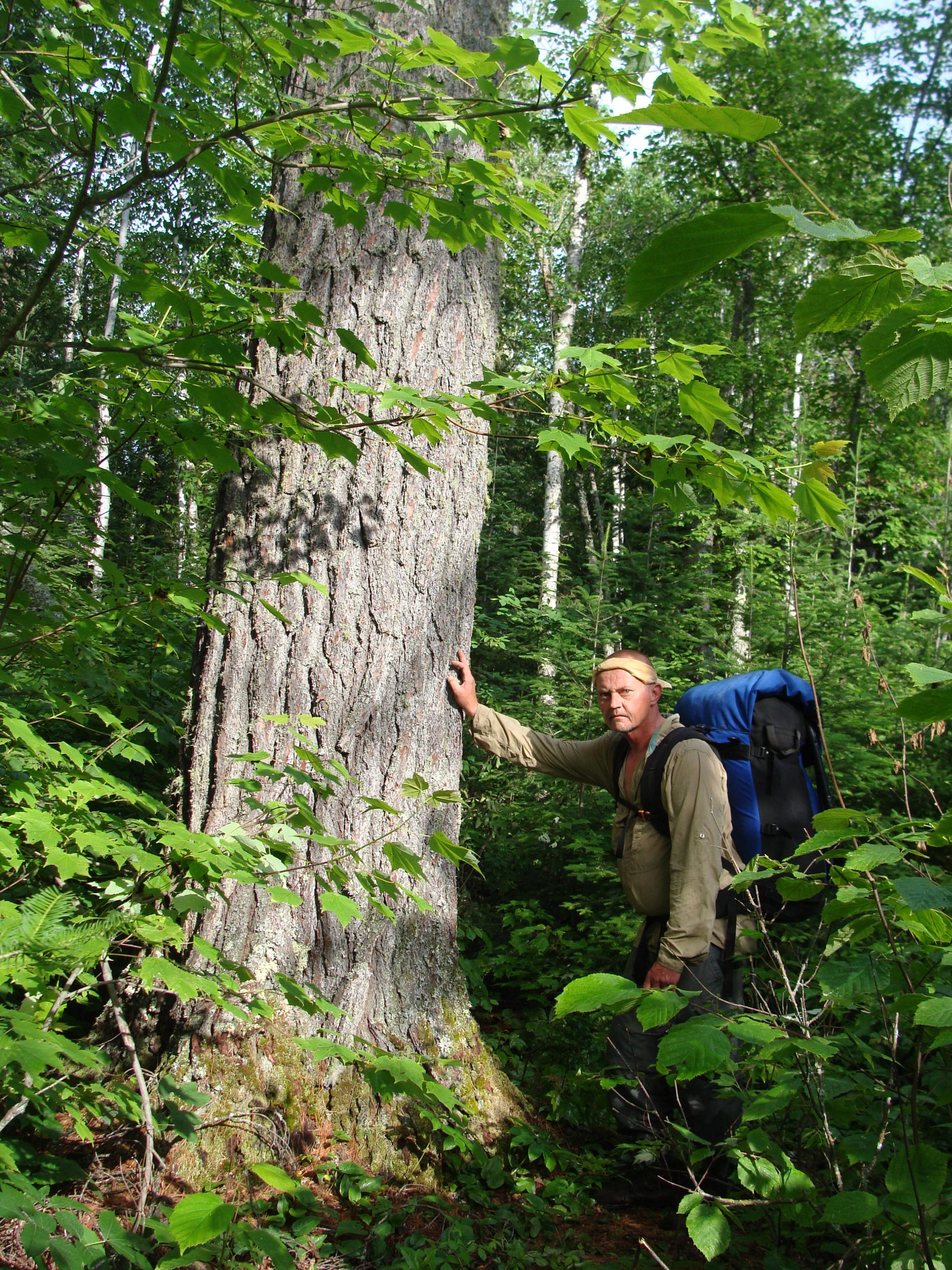
|
| Fingolfin |
09/28/2023 07:42PM The condition of those bushwhacks was one of my main concerns as well, cowdoc. I’ll PM you about specifics and really appreciate your advice! - just looking at the map, it seems like the first one from Camel to the pond didn’t get burnt too badly, but the southern shore of Hoare got pretty well scorched along what I understand to the last bushwhack in. I wonder if those old growth pines I’ve read about held up, and how dense any new growth has already become. The northern shore of Camel doesn’t look like it got the worst of the fire, but I think I read a thread that the nice site on the southern shore of the north arm was wiped out. Would the problem there just be widowmakers, or something else as well? I’d think as long as there aren’t branches overhead, tent camping could be possible if new growth hasn’t filled it out too much. Bobber, I’m curious about the same - I’d read that as “the campsites got wiped out,” but very interested to hear if anyone has tried camping in the impact zone. Appreciate the welcome! |
| bobbernumber3 |
09/28/2023 09:56AMFingolfin: "...According to the burn map, pretty much all the campsites were wiped out. I’m wondering what would render them unusable..." When entering thru Cache Bay a couple weeks ago, Peter told me about the burn areas on my route, particularly Tanner Lake. His comment was "don't plan to camp there as there is no camping". I don't know if that meant camp sites were unavailable, or that camping was not allowed... something to check out regarding Camel Lake, I think. Welcome to the board! |
| cowdoc |
09/28/2023 08:18AM My email is not posted. If you want more info....cowdoc87@gmail.com |
| cowdoc |
09/28/2023 07:31AM I worry about what the fires have done to those bushwacks....especially Camel to first no name and last no name to Hoare. The first one does follow a creek somewhat. The other into Hoare does not. We came into Camel from north. After foray into Hoare, we left Camel to east via Cutty Creek, which if recall was with the current which is not much. From the fire maps, I thought maybe the nice NE site on Camel may have been somewhat spared. Boots on the ground may have first hand reports. We stayed on the island site on Hoare, did not find the other "marked" site on the SW side but did find an old site on the west side. I hope it is not a tangled mess of charred snags. |
| Fingolfin |
09/27/2023 07:51PM Hi all! First time poster, but I’ve been lurking for awhile. As an introduction, I’m an Army vet (Afghanistan) and Eagle Scout and have made one trip to the Q all the way back in 2001. We did a loop from PP to Kahshahapiwi via Isabella and Side, over to Agnes via Trant and Silence, and back to PP over about 8 days. It was one of the best experiences of my life, and I’ve been feeling the call to return. Reading through many of the posts here, I’ve felt a particular call toward Hoare - the remoteness, the challenge, and the small amount of people who have seen the lake make me want to attempt it. I understand those who have been are hesitant to share much in the open and I respect that. Based on what I’ve seen, I think I understand the options to get there and would want to do Agnes-Kawnipi-Camel and attempt the bushwhack from Camel. I’ve read bojibob’s account of the route and have studied the maps, so I think I have an idea of where to look/what to do. I’ll try to do some private messaging closer to the trip if anyone is willing to offer more guidance. My overall ideal loop would be Hoare from PP via Agnes, Kawnipi, and Camel, then down to Kahshahapiwi and over to Agnes via Trant and Silence before finishing at PP. All that said, I have a few tactical questions, mostly not directly Hoare-related, and would appreciate the input of trippers lucky enough to get to Quetico regularly: 1. Has anyone been on Camel since the 2021 fires? According to the burn map, pretty much all the campsites were wiped out. I’m wondering what would render them unusable other than dead branches overhead (I’d be using tents, not hammocks) - if Camel doesn’t have any viable campsites, it seems like Nan would be the next closest base camp option. 2. I’ve seen a figure of ~8 hours for the bushwhack from Camel to Hoare - is that for single or double portaging? 3. Not having done a bushwhack before, do you blaze the trail with strips of cloth or something and then remove them on the way out? I want to respect LNT. 4. Which direction does Cutty Creek flow? Is there a time of year that’s best to navigate it? I’ve seen notes about some of the rivers but couldn’t tell this one. 5. Has anyone been on Ptolemy Lake? It’s adjacent to my route and I see a couple possible (bushwhack) routes to it on the map, but wondering if the juice is worth the squeeze there. |
Community Links
 Search BWCA.com
 Donate
 Featured Sponsor
