|
||||
 Boundary Waters Quetico Forum Trip Reports Trip Report - LIS North Loop, April 2012 Reply Boundary Waters Quetico Forum Trip Reports Trip Report - LIS North Loop, April 2012 Reply
|
| Previous Messages: | |
| Author | Message Text |
| mcspin50 |
03/01/2013 06:43PM UncleMoose, I was directed to your trip videos when I asked about planning a trip into BW with my grown kids this summer. All I can say is Wow! Beautiful videos, really gave me a feel for what it'll be like. Of course, I'm not planning on going during sleet and snow season...more like mosquito season. I sure hope some of those portages are dried up and/or cleared up a little when we go through, but at least we'll know that some of them aren't walks in the park. Thanks again. Great job. Lil M. |
| RJB |
07/10/2012 09:23AM Hello again, I posted a trip report for the loop from "EP14 exit EP16". It was a great trip. Bob |
| UncleMoose |
05/29/2012 12:13PM Based on the timestamps on my photos, it took me about 2 1/2 hours from Eugene to Slim. That seems really long to me, but I guess the weather and portage conditions contributed to that. This was also double portaging. The portage from Fat to Slim alone took the majority of the time. |
| RJB |
05/29/2012 10:23AM I hiked into the north shore of Big Moose Lake from the Echo Trail last October. I called back home (Georgia)and the cell reception was amazingly clear. Anyway we may need to see if we can get a satellite phone just in case. On your return how long do you think it took you to get from where you entered Eugene Lake to get to Slim Lake? I'm considering Eugene as an alternative site for the first day. It would seem to allow more options on the layover day. You've been very helpful (this site is great) and I appreciate it. |
| UncleMoose |
05/29/2012 09:28AM Couldn't tell you for sure about cell reception (I don't bring a cell phone). But if it's any indication, I don't think I had a signal at the entry point (my phone uses AT&T). I usually lose my Ely signal past the Hegman EP, well before LIS. Orr is not a lot closer to the LIS EP than Ely, so I doubt you'd get any kind of reliable signal along this route. If you were to hike up somewhere high, like the old fire tower site above Devil's Cascade, I wonder if you might be able to eke out something. |
| RJB |
05/29/2012 08:58AM For emergency purposes did you have any cell coverage in this area? I've had coverage on Trout, Moose, Cummings but have not needed it north of the Echo Trail. Thanks. |
| UncleMoose |
05/20/2012 07:38PM Great suggestion about including weather/temperature info. For completeness sake, I did save the temperature data from nearby Orr, MN and that's below: Day 1 - High: 51; Low: 26 (Friday, April 20) Day 2 - High: 39; Low: 32 (Saturday, April 21) Day 3 - High: 44; Low: 32 (Sunday, April 22) Day 4 - High: 60; Low: 32 (Monday, April 23) Day 5 - High: 62; Low: 35 (Tuesday, April 24) Day 6 - High: 48; Low: 39 (Wednesday, April 25) |
| Mashuga |
05/20/2012 05:39PM That was a great video UncleMoose. I'm very techno challenged and what you did makes me all the more impressed. It would have been nice if you could've posted what the temp was at the beginning or end of each clip. Thanks for the report and it makes me want to be there all the more. |
| Rambler_Dog |
05/20/2012 11:16AM Thank you very much Uncle Moose. Every time I read a report I feel as if I am going along for the trip. But your video really made feel as if I was there. Thanks again. |
| bear bait |
05/16/2012 06:23PM Great video! Especially day 2. It's something special paddling in a snow fall. |
| RJB |
05/15/2012 01:07PM Thanks again for the information. I know that several of the lakes are quite deep that we will pass through on this trip from EP14 to EP16, but honestly I am a novice when it comes to Trout fishing. I much prefer and am generally pretty successful fishing for bass. Having said that, if you or anyone has some suggestions for trout fishing on Fat, Gun, or Oyster I'd be glad to hear it. I assume that the trout will be deep at that time of year. Also are there any crappies in this section, ... that would make a great meal. I've passed along your video to several people and they are getting excited about the trip. Can't wait. |
| UncleMoose |
05/14/2012 05:26PM I didn't get a close look at the campsite on Fat when I was passing through, but it didn't look bad from a distance. You might be able to get more info from this trip report. If your group likes fishing, it sounds like Fat is a good trout lake. |
| boonie |
05/14/2012 04:18PM There's at least one campsite on South that is pretty nice. I stayed at one on Steep next to the portage from South (I had enough for the day after that) that was fine for me solo, but might not work so well for a group of any size. I did not check out other sites. |
| RJB |
05/14/2012 03:04PM Thanks. A related question perhaps for my group would be, "Where would you rather end up at the end of the first day, Fat or Steep?" I would imagine the group will be worn out for the day after either of those two portages. |
| boonie |
05/14/2012 02:41PM RJB- I have not done the Fat/Slim portage, but did do the South to Steep portage and as the guy coming downhill said, "there's a reason they call it Steep Lake". Here is a link to Voyageur map of the area. You can compare the contours and see that the portage from South to Steep is steep. The terrain between Fat and Slim is much more level, although that portage would be over twice as long and probably not in as good condition. |
| UncleMoose |
05/14/2012 10:04AM Yup, I'd say 5-6 hours between Slim and the entry point is spot on. That is also the easier half, with more paddling and less portaging (assuming wind and waves aren't an issue on East Loon and Little Loon). I have not done the South/Steep portage, so I can't give you a personal comparison. But from what PortageKeeper and others have said, it sounds like the Fat/Slim portage is a very tempting alternative, especially coming from the direction you are. The one wrinkle in all that is the fresh downfall along the Fat/Slim portage from the spring storm. I doubt that trail will be a priority for clearing, so that could slow things down there. But then again, the portages between Slim, South and Steep may not be in all that great of shape either by June. |
| RJB |
05/14/2012 09:31AM Thanks. We will be traveling the opposite direction. I was assuming the trip from EP14 to Slim would take 5-6 hours and am not certain whether we will proceed through South/Steep or go through Fat on the way to Finger. I have read that the Steep Lake portage is steep and tough but I'm wondering if the portage you took from Fat would be just as difficult as it will also be uphill from Slim. Have you done both portages to be able to make the comparison? Again, great video I just watched it for the 2nd time and forwarded it to others on the trip to psyche them up. |
| UncleMoose |
05/14/2012 09:12AMquote RJB: "How many hours did it take you to get from Finger Lake out to the entry point on the last day?" With the poor weather and portage conditions, it was a very full day for me. I double-portage and can sometimes be a bit poky (taking pictures and such). The trip out from Finger to the LIS entry point took me a solid 12 hours without any real breaks. It was a lot of portaging for one day. My GPS indicated close to 20 miles traveled total. |
| RJB |
05/14/2012 07:53AM Great Video. Thanks for sharing. I plan to take a group through much of that area in late June. How many hours did it take you to get from Finger Lake out to the entry point on the last day? |
| wildernessfan2 |
05/13/2012 05:25PM Great Video Report! Thanks for the trip! |
| joe47 |
05/10/2012 09:42AM WOW! Thank you. If a picture is worth a thousand words, that video set is worth a book to a newcomer like me. |
| boonie |
05/09/2012 07:07PM TomT - I basically do the same as Uncle Moose and what you are contemplating doing since I trip in late Sept. I usually keep a sleep/emergency pair along with socks and watch cap with my sleeping bag in a waterproof compression stuff sack. I usually take a light and a medium baselayer or a medium and heavy if it's going to be really cold. I think two baselayers is the lightest, most compact, and most versatile way to get more warmth. In late fall there can be a significant wind chill when it's really windy, especially when it's wet, too. I also keep all spare clothes in a waterproof compression stuff sack. |
| TomT |
05/09/2012 05:36PMquote UncleMoose: "quote TomT: "Your gear list is all very similar to mine except, you have a dedicated outfit that you sleep in. You seem to bring two complete pairs of thermal underwear top and bottoms. Sup wit dat?" That is a good idea for a cold weather trip. Especially solo. I'm hoping to do a solo to the same area the last week of Sept. and I think I will adopt your idea. Thanks. |
| UncleMoose |
05/09/2012 09:39AMquote TomT: "Your gear list is all very similar to mine except, you have a dedicated outfit that you sleep in. You seem to bring two complete pairs of thermal underwear top and bottoms. Sup wit dat?" Yeah, good point. My thinking on that is as follows: The second (sleeping) set is a SmartWool pair that only comes along on trips when temps might go well below freezing. As happened on this trip, it's all too easy to get the travel set soaked if it's raining (or snowing). The "sleeping" set is an extra warmth layer for cold nights and can also double as a backup if the "travel" set gets wet and needs time to dry. If I'm confident temps will stay near or above freezing for a trip, this extra set stays at home. But especially in early spring, when the water is so cold, I feel a lot better having the extra set. If I were to dump the canoe, for example, those extras could be critical. I guess this set is mostly just a precaution and added comfort for cold trips. They actually came in very handy on Day 3 of this trip when it was cold and I was drying out the travel pair. |
| Cedarboy |
05/09/2012 08:09AM Great videos. Photograpy has not been my thing,but these videos have got me thinking. CB |
| TomT |
05/09/2012 06:49AM Your gear list is all very similar to mine except, you have a dedicated outfit that you sleep in. You seem to bring two complete pairs of thermal underwear top and bottoms. Sup wit dat? |
| msray53 |
05/08/2012 09:47PM Nicely done! I enjoyed the sounds of nature. The videos represented the experience beautifully. Very effective presentation. Mike |
| UncleMoose |
05/08/2012 12:37PM Yeah, I don't know how easily you travel, but 10 days would give you maybe 4 days of rest and 6 days of shorter paddling segments. The shorter paddling segments could be used to split up the longer portages along the way. The longer portages aside, the two bigger obstacles might be the flooded portage between Hustler and Oyster and then the route you take to Slim Lake. If you go to Slim via Fat Lake, you'll have the less traveled portage going that way. If you go via Steep and South, the portage between those lakes is reportedly difficult due to its steepness. Triple-portaging these longer trails will also drain a lot of energy and take up a lot of time. If you can get down to a double-portage that would help quite a bit for this particular trip. I've posted my complete gear list at the following link: Gear List for April, 2012 LIS River North Trip My food did consist of Freeze Dried meals to help cut down on packing. As you can gather from my gear list, food is not generally a priority for me when I travel, especially solo. As for the blue thing on my pack, I think that may have just been my PFD, as I don't recall bringing anything else that was blue. I basically just had two packs, the main green CCS pioneer pack and my smaller red day pack. |
| nctry |
05/08/2012 12:09PMquote BigAl2: ""uncleMoose": Enjoyed (Thank you) watching your video's in your trip report. I am planning a solo trip via "little indian Sioux" EP to Pauness, Shell, Lynx, Ruby, Hustler, Oyster on June 7. Because of your videos, I am thinking about continuing the loop through Gabeonequet, pocket, finger, bear track, slim, loon and back to Pauness (rather then back tracking). I am a older person and am thinking it will take me about 10 days to do this loop. I would like to take a a 2 day rest at Oyster and also at maybe Finger. Do you think this would be about how long it would take me? In past years I had to tripple portage and my past solo trips were about 6 days so I think I need to lighten my load also. I would take some fishing gear with me hoping that I can have a meal or two. It looked like your gear was very very light, I am very interested in the gear and the food that you (UncleMoose) used on your trip. Would you be willing to list your gear ? Did you use dehydrated food for your trip entirely? What is that small blue pack on one of your packs ? Thank you in advance for any info and help you can give me. I've done that trip and you should have no trouble doing it in ten days. Some long portages and the one to Oyster looked even worse than I remember it being. The Pocket, finger, Thumb used to be my favorite trip. With ten days you should have a few layovers and not have to travel far on traveling days. Going the loop would be much better than backtracking. |
| BigAl2 |
05/07/2012 10:30PM "uncleMoose": Enjoyed (Thank you) watching your video's in your trip report. I am planning a solo trip via "little indian Sioux" EP to Pauness, Shell, Lynx, Ruby, Hustler, Oyster on June 7. Because of your videos, I am thinking about continuing the loop through Gabeonequet, pocket, finger, bear track, slim, loon and back to Pauness (rather then back tracking). I am a older person and am thinking it will take me about 10 days to do this loop. I would like to take a a 2 day rest at Oyster and also at maybe Finger. Do you think this would be about how long it would take me? In past years I had to tripple portage and my past solo trips were about 6 days so I think I need to lighten my load also. I would take some fishing gear with me hoping that I can have a meal or two. It looked like your gear was very very light, I am very interested in the gear and the food that you (UncleMoose) used on your trip. Would you be willing to list your gear ? Did you use dehydrated food for your trip entirely? What is that small blue pack on one of your packs ? Thank you in advance for any info and help you can give me. |
| TomT |
05/04/2012 09:48PM Well, that was very entertaining. The kids will love it. I just finished watching your last day out which was rainy and hard going and I was struck by what you wrote at the end. *paraphrase "Another great trip to canoe country". That is exactly the kind of attitude a person needs to get through a trip like that. You just gotta roll with it (the weather) and you get what you get. I enjoyed it and will definitely use it as a reference for when I do that loop going the other way hopefully in Sept. Thanks for puttin' in the hard work of setting up the camera. That stuff takes time. |
| UncleMoose |
05/04/2012 12:02PMquote UncleMoose: "I still need to process the GPS track data for the Fat to Slim portage, but that feels about right in terms of length. It felt like about a mile, maybe a touch more. All the rain and new deadfall probably made it feel a bit longer than it actually is." As I suspected, the conditions did make the portage feel longer than it actually is. My GPS track data indicates it's closer to 256 rods (8/10ths of a mile). The detailed track data can be found at the following link: Fat to Slim Portage GPS Track 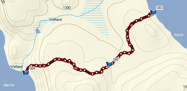 |
| nctry |
05/04/2012 11:20AMquote UncleMoose: "quote nctry: "Two questions... Is that boat a RX Wilderness? And was that hand axe the Gerber from BWJ?" I had the identical canoe at Wing Night last week. :) Minus the bdb's |
| UncleMoose |
05/04/2012 10:49AMquote nctry: "Two questions... Is that boat a RX Wilderness? And was that hand axe the Gerber from BWJ?" Yes, the canoe is a Royalex Wilderness, and the axe is the Gerber Camp Axe (I believe the same one advertised in the BWJ). |
| nctry |
05/04/2012 10:29AM Two questions... Is that boat a RX Wilderness? And was that hand axe the Gerber from BWJ? I've never seen the "furnature" on Gebe before. That is something. |
| UncleMoose |
05/04/2012 09:32AMquote OneMatch: "I'm curious how you mounted your camera? Sometimes it appears it is on you and sometimes on the boat." Jerry, I used a variety of different mounts. I have a more traditional, compact/light-weight tripod that worked well for shots around camp. Then I also brought a Joby GorillaPod and a small clamp-on mount for attaching to tree branches, thwarts and so on. The combo worked well, but I also have ideas for future improvements. Most of the canoe paddling shots were done with the small clamp-on mount attached to a thwart. When portaging, I mostly just hand-held the camera on my return trip of the double-portage. The one time when I carried the canoe, I used the clamp mount to attach the camera to my PFD. I think BDBs make good decorations for the canoe, don't you think? :o) |
| OneMatch |
05/04/2012 06:44AM Wow, Uncle Moose, you have set a new standard for trip reports. I love this. It made me feel like I was there with you (except I was warm and dry). I'm curious how you mounted your camera? Sometimes it appears it is on you and sometimes on the boat. Also, I think you need more bdbs. Thanks again. See you this summer. |
| paddlinjoe |
05/03/2012 10:15PM Really nicely done. Anyone new the the BWCA asking for advice, should view your video 3-4 times. Great way to understand portage and water conditions, clothes needed, type of gear to use, how to split wood, build a fire, trim a canoe... So much good information and on top of that conveying the beauty of why many enjoy visiting. A true blessing of a report. |
| UncleMoose |
05/03/2012 07:20PMquote nctry: "Nice report! Good to know the portage from Fat is still there. I plan to do that this fall... and haven't done it in many years. I think we figured it to be about a mile long. And the portage to Oyster hasn't got much better since I was there a couple years ago. I expected an "OH SH..!". When you showed the Oyster portage, or did that get edited out. :) I'm doing the Lean thing too this year and look forward to using it a lot. Got the Lean 2..." I still need to process the GPS track data for the Fat to Slim portage, but that feels about right in terms of length. It felt like about a mile, maybe a touch more. All the rain and new deadfall probably made it feel a bit longer than it actually is. One of the primary motivations for this video was to create something to show my nieces and nephew what Uncle Moose actually does on his canoe trips. Fortunately, my colorful comments upon reaching the Oyster portage occurred before the camera started rolling. They don't need to know that part of canoe tripping until they're old enough to try it themselves. :o) |
| nctry |
05/03/2012 06:40PM Nice report! Good to know the portage from Fat is still there. I plan to do that this fall... and haven't done it in many years. I think we figured it to be about a mile long. And the portage to Oyster hasn't got much better since I was there a couple years ago. I expected an "OH SH..!". When you showed the Oyster portage, or did that get edited out. :) I'm doing the Lean thing too this year and look forward to using it a lot. Got the Lean 2... |
| iwegean |
05/03/2012 06:32PM Nicely done. Quality video report. I really like the high water conditions of early spring. Flooded portages are interesting and the downed trees only add to the experience....and yes, I broke my first paddle last year. Always bring a spare! |
| DanCooke |
05/03/2012 06:30PM Maybe I should turn away from the dark side! |
| UncleMoose |
05/03/2012 06:03PMquote DanCooke: "What kind of camera system did you take the video with?" Thanks, Dan! The camera is a new Canon S100 point and shoot. It captures RAW stills as well as 1080p video. I got it for just such occasions when I want to travel lighter (without the bigger cameras) but still capture good quality. This was the camera's second test run, and it passed with flying colors. |
| DanCooke |
05/03/2012 05:16PM Awesome trip with an awesome trip report. The video really worked well in conveying the solo nature and challenges the trip had for you. What kind of camera system did you take the video with? Thanks for sharing your adventure. |
| Ho Ho |
05/03/2012 03:12PM Thanks for the videos, Tom! Very cool (cold?). That "portage" to Oyster (I think it was) was pretty intense, as was the portage to Slim. I'm glad you got dry weather and some sunshine to dry out the day after the sleet. This looks like a great area to explore. |
| boonie |
05/03/2012 07:23AMquote UncleMoose: "quote TuscaroraBorealis: "Hey, I finally got the videos to work for me!!!" When I was there in late Sept, I also went days without seeing anyone else, but we were windbound for a bit :). If memory is right, between Little Loon and Oyster I saw 4 guys on the South to Steep portage and a tandem on Finger. |
| twston |
05/02/2012 09:34PM Very well done!!!Headed there end of July. |
| UncleMoose |
05/02/2012 07:47PMquote TuscaroraBorealis: "Hey, I finally got the videos to work for me!!!" Cool! Thanks, TB. I love complete solitude, but even this trip became a little odd by how empty and quiet it was. There was one group of two guys also going in on the morning I started. They got a good head start, and I didn't see them until Little Shell, where they had stopped to set up camp. Other than that, there was no sign of people at all until driving through Ely on the way home. Going in fall, eh? No guarantees about no snow then either! :o) |
| TuscaroraBorealis |
05/02/2012 07:24PM Hey, I finally got the videos to work for me!!! I think you were right about the internet connection. You did a fantastic job of editing. There was always some sort of action going on. And you kept it short when there wasn't. Still giving us a sense of what you where seeing without overdoing the video. Must've been an awesome feeling to have the area to yourself? Glad you were able to take advantage of our early spring and get one under your belt before May. We're planning on doing a portion of that route this fall. So your videos gave us a taste of what we can expect. Hopefully without the snow! :) Thanks for taking the time to share your story. |
| UncleMoose |
05/02/2012 07:00PM Thanks everybody. Misqua, yes. It was a bit cold at times, especially the afternoon and night it snowed/sleeted. Everything not in the pack got thoroughly soaked that day (and the last day out for that matter, I guess too). Boonie, I did luck out on the wind, particularly the last day going through Little Loon and East Loon Bay. Wind on top of the rain would have made it a much longer day than it already was. The shelter is a Lean 1 Plus. It's new to me this year, and I'm seeing how it goes as both shelter and tarp. So far so good. One of the things I like about it is the option to leave the additional tarp at home and skip the extra bulk. When I was caught in the snow/sleet storm, it was nice being able to sit in it and make a meal like I ordinarily would under a tarp. On future trips, I might still bring the extra tarp. I guess it just all depends on the trip and how light I'd like to travel vs. how much comfort I want. Thwarted, I double portage and consider myself a bit poky (I spend a bunch of time doing things like taking videos). I also had weather and portage issues to contend with, so exiting from Finger is definitely not a big problem, especially with the longer days in June. If you single portage, added bonus. Still, it's close to 20 miles of paddling and portaging with a few lengthy portages along the way. The Fat to Slim portage was a bit longer and tougher than I had expected from reports, but I'm sure the rain, wet trail and new downfall probably had a lot to do with this. If you do your due diligence on this site and get the proper locations for the portage landings, they are not that hard to find (rock cairns mark both sides). The trail itself is a bit curvy and overgrown in spots, but it appears to be well enough traveled that you shouldn't have a problem following it (except maybe in a few of the new downfall spots). I have a detailed GPS track of the portage that I'll try to post when I get a chance. |
| boonie |
05/02/2012 02:20PM Thanks, that was great, Tom. I've never seen portages in that kind of shape. I went in #14 in late Sept 2006 on my 2nd BW trip (1st BW solo) and out #16, so I went through most of that route the other direction. You had a lot more water and tougher portage conditions, but it looks like you had fewer wind problems. I really enjoyed the video - it will be a good link for people who want to see what BW tripping is like :). It looks like you use the Lean as a combination tent/tarp shelter and don't take a separate tarp...? Is it a Lean 1 or 2? |
| Thwarted |
05/02/2012 02:13PM Wonderful way to do a report. Thanks for the last day info. I plan to make this trip in June and was very interested to note that you made the EP from Finger Lake. I might make that an option. How was the Fat to Slim portage? |
| Nick78 |
05/02/2012 01:54PM Fantastic report. Nicely done with the video too. Almost seems like you are right there! |
| misqua |
05/02/2012 12:48PM Thanks for the great videos,pretty nice to watch sitting here at my desk. That was very early trip. Looked a little chilly. |
| UncleMoose |
05/02/2012 11:00AM New Trip Report posted by UncleMoose Trip Name: LIS North Loop, April 2012. Entry Point: 14 Click Here to View Trip Report |
Community Links
 Search BWCA.com
 Donate
 Featured Sponsor
