|
 Boundary Waters Quetico ForumTrip Planning ForumAbandoned sites in BWCA, Quetico, and surrounding areas
|
 Forum Sponsor
Author
Text
")
03/28/2019 08:39AM
Hi all,
I am becoming increasingly interested in the history of the BWCA, Quetico, and surrounding areas. What abandoned sites do you know of that I could research? I am interested in any of the old cabins, logging roads, mines, mining equipment, etc. Feel free to provide as much information as you're comfortable with regarding location!
I am becoming increasingly interested in the history of the BWCA, Quetico, and surrounding areas. What abandoned sites do you know of that I could research? I am interested in any of the old cabins, logging roads, mines, mining equipment, etc. Feel free to provide as much information as you're comfortable with regarding location!
Reply
Reply with Quote
Print
Top
Bottom
Previous
Next


03/28/2019 09:49AM
Don't blame me or the guy responsible for this website if you get lost in the history ... or the woods. :-)
Be sure not to overlook the hard-to-see link he has on the left side of his home page to his Gunflint/Superior content.
Website:
Port Arthur, Duluth and Western Railway
YouTube:
Port Arthur, Duluth & Western Railway
Be sure not to overlook the hard-to-see link he has on the left side of his home page to his Gunflint/Superior content.
Website:
Port Arthur, Duluth and Western Railway
YouTube:
Port Arthur, Duluth & Western Railway

03/28/2019 09:56AM
Poke around in the Cool spots in canoe country forum.
Especially check out the artifacts and the old cabins threads.
Especially check out the artifacts and the old cabins threads.
03/28/2019 12:32PM
Old abandoned gold mine just off the north end of the Kelly to Jack portage. Short trail to the shaft of the mine which you can go in for a bit before it dives downwards and is underwater, and a lot of relics lying around. Don't know any of the info around it though.
03/28/2019 04:45PM
Some where on the Quetico River in 2006 I think. Did a loop back down through Sturgeon Lake and the Malione River. Just the corner section left but still cool to find it. 

Be Somebody Who Makes Everybody Feel Like a Somebody
03/28/2019 07:23PM
Maxus: "Hi all,
I am becoming increasingly interested in the history of the BWCA, Quetico, and surrounding areas. What abandoned sites do you know of that I could research? I am interested in any of the old cabins, logging roads, mines, mining equipment, etc. Feel free to provide as much information as you're comfortable with regarding location!
"
Look up the thread Jackpine Jim in the general discussion forum. There is a wealth of information on it by people who were born and lived in the area that became the BWCA.
03/29/2019 04:50AM
minnmike: " Where is Cadillac narrows on Crooked?
"
North east exit of Friday Bay on Crooked Lake in narrows. On Canadian shore. Look for the island that looks like a Capital "L" laying on its side at the top of Friday Bay and paddle the narrows between the island and the Canadian shoreline.
It can be seen from the canoe on the water if you don't have the proper paperwork.
"Many men go fishing all of their lives without knowing it is not fish they are after"
~ Henry David Thoreau
03/29/2019 06:55AM
snakecharmer: "minnmike: " Where is Cadillac narrows on Crooked?
"
North east exit of Friday Bay on Crooked Lake in narrows. On Canadian shore. Look for the island that looks like a Capital "L" laying on its side at the top of Friday Bay and paddle the narrows between the island and the Canadian shoreline.
It can be seen from the canoe on the water if you don't have the proper paperwork. "
Car narrows. I'm sure you can get out and look around.
03/29/2019 08:26AM
gravelroad: "Don't blame me or the guy responsible for this website if you get lost in the history ... or the woods. :-)
Be sure not to overlook the hard-to-see link he has on the left side of his home page to his Gunflint/Superior content.
Website:
Port Arthur, Duluth and Western Railway
YouTube:
Port Arthur, Duluth & Western Railway "
I just spent over an hour on that site and will likely check out the YouTube too. Very cool, and what dedication that guy has!
03/29/2019 02:26PM
We hiked around Angleworm a couple years ago, and near one of the sites on the east side is an old gas pump and tank. I believe Angleworm was an old logging site. Found a real old and large pulley, and a couple big chunks of saw blade when we were there.
03/30/2019 12:47AM
Some spots that I have found in research. (Some visited, some not):
1. Mine already mentioned between Kelly and Jack.
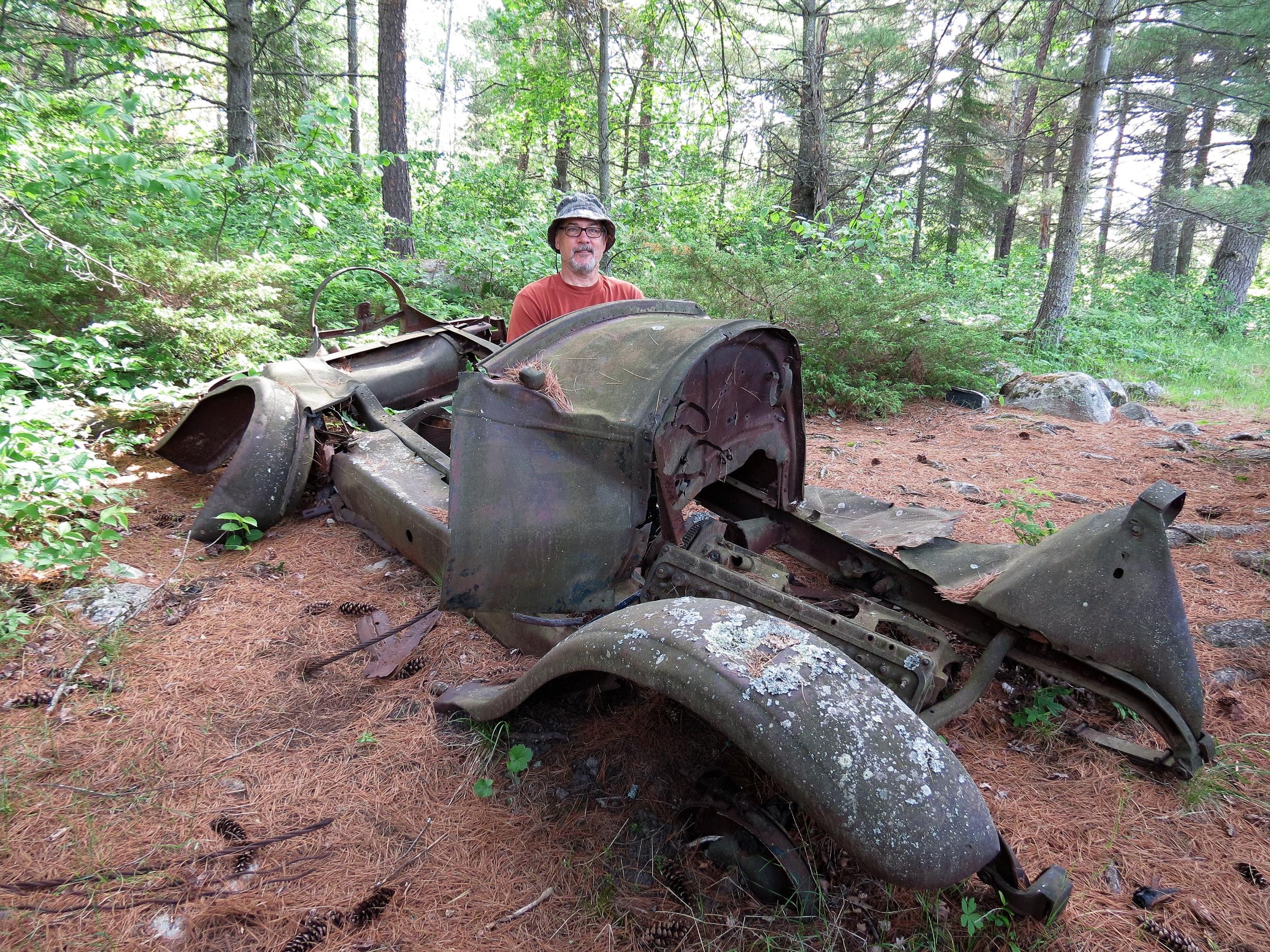
2. The airplane frame on the north shore of Zenith Lake.
3. There is a site of an old Fire tower west of Kelso Lake.
4. Path to site of old fire tower off the south shore Kekakabic Lake.
5. Apparently there used to be a private resort on an island of Fraser Lake. A set of concrete steps is all that supposedly remains.
6. Of course, Dorothy Molter’s island is well documented.
7. Apparently, there was a Native American family(?) that lived in a cabin on the shores of Beth Lake several years after the creation of the BW.
8. I have seen maps (USGS Quad) that show a logging road crossing the portage between Burnt and Kelly Lakes.
9. The portage between Sawbill and Alton Lakes used to have a railroad car to hoist boats between the lakes.
10. There is what many believe to be a Viking Dolman on the Kelso River between Kelso and Lujenida Lakes.
1. Mine already mentioned between Kelly and Jack.
2. The airplane frame on the north shore of Zenith Lake.
3. There is a site of an old Fire tower west of Kelso Lake.
4. Path to site of old fire tower off the south shore Kekakabic Lake.
5. Apparently there used to be a private resort on an island of Fraser Lake. A set of concrete steps is all that supposedly remains.
6. Of course, Dorothy Molter’s island is well documented.
7. Apparently, there was a Native American family(?) that lived in a cabin on the shores of Beth Lake several years after the creation of the BW.
8. I have seen maps (USGS Quad) that show a logging road crossing the portage between Burnt and Kelly Lakes.
9. The portage between Sawbill and Alton Lakes used to have a railroad car to hoist boats between the lakes.
10. There is what many believe to be a Viking Dolman on the Kelso River between Kelso and Lujenida Lakes.
03/30/2019 06:16AM
There are old rail lines in many places (I follow the earlier mentioned one on the Gunflint on Instagram, very cool)
The short portage between Sandpit and Jackfish Bay (and all the way to Range) over by Mudro is on an old RR grade. Very flat and wide! If you look at aerial photos you can follow that old line south away from the BW for quite a ways.
The short portage between Sandpit and Jackfish Bay (and all the way to Range) over by Mudro is on an old RR grade. Very flat and wide! If you look at aerial photos you can follow that old line south away from the BW for quite a ways.
Reply
Reply with Quote
Print
Top
Bottom
Previous
Next

Subscribe to Thread
Become a member of the bwca.com community to subscribe to thread and get email updates when new posts are added. Sign up Here
Community Links
 Search BWCA.com
 Donate
 Featured Sponsor
