|
 Boundary Waters Quetico ForumListening Point - General Discussion Storm heading toward the BW
|
 Forum Sponsor

Author
Text
")


07/15/2019 06:44PM
My friend noted the hot night last night, and this morning, and pulled out this morning ahead of the storm.
Good call. She sent me a screenshot of the radar and it looked nasty. They have a cabin nearby so not all is lost. Better to be safe than sorry.
Good call. She sent me a screenshot of the radar and it looked nasty. They have a cabin nearby so not all is lost. Better to be safe than sorry.
“The Wilderness holds answers to more questions than we have yet learned to ask.” - Nancy Newhall
07/17/2019 09:14PM
nctry: "Could be another rocky day. I see another storm heading my way and aiming for canoe country... hopefully it’ll stay a little south. Sorry Karen... haha."
Yep, tornado warning for Quetico. Hope my son's group is safe tonight.
07/26/2019 02:07PM
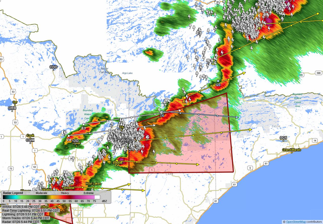
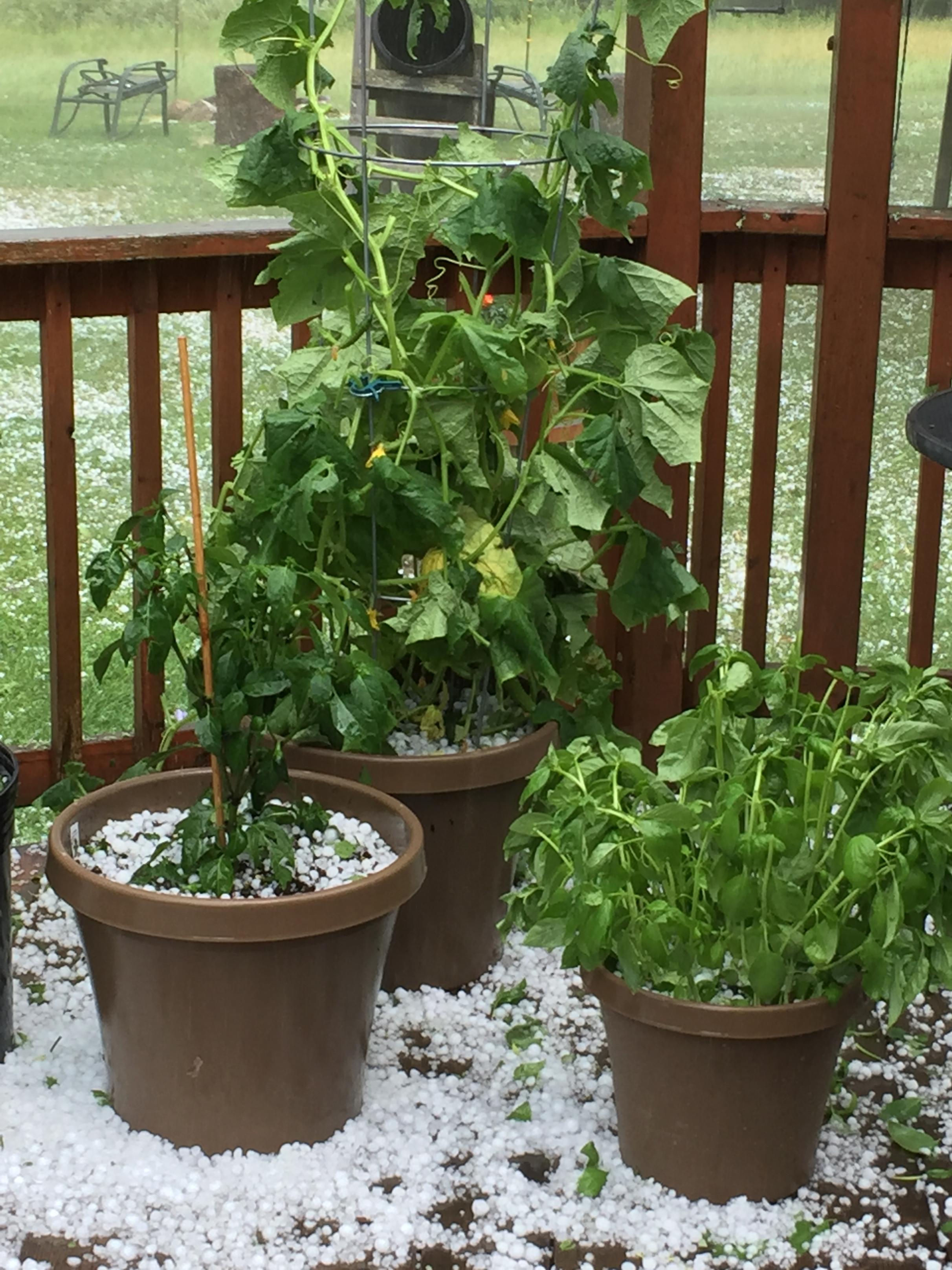
Likelihood of strong/severe storms for much of the BwcaW later today is high. As of this writing large hail ( up to 2" diameter) and wind 60+ mph seems to be the greatest threat of severe weather though an isolated tornado is possible. 

The two loudest sounds known to man: a gun that goes bang when it is supposed to go click and a gun that goes click when it is supposed to go bang.
07/26/2019 05:51PM
WUUS53 KDLH 262240
SVRDLH
MNC031-075-262330-
/O.NEW.KDLH.SV.W.0090.190726T2240Z-190726T2330Z/
BULLETIN - IMMEDIATE BROADCAST REQUESTED
Severe Thunderstorm Warning
National Weather Service Duluth MN
540 PM CDT Fri Jul 26 2019
The National Weather Service in Duluth MN has issued a
* Severe Thunderstorm Warning for...
West central Cook County in northeastern Minnesota...
Northern Lake County in northeastern Minnesota...
* Until 630 PM CDT.
* At 540 PM CDT, a severe thunderstorm was located near White Iron
Lake, or 7 miles southeast of Ely, moving east at 50 mph.
HAZARD...70 mph wind gusts and ping pong ball size hail.
SOURCE...Radar indicated.
IMPACT...People and animals outdoors will be injured. Expect hail
damage to roofs, siding, windows, and vehicles. Expect
considerable tree damage. Wind damage is also likely to
mobile homes, roofs, and outbuildings.
* Locations impacted include...
Clear Lake, Winton, White Iron Lake, Snowbank Lake, Forest Center,
Little Saganaga Lake, Fall Lake, southern Boundary Waters Canoe
Area Wilderness, Birch Lake, Sea Gull Lake, Bald Eagle Lake, Gabbro
Lake, Alice Lake, Perent Lake, Ojibway Lake, Farm Lake, Phoebe
Lake, Kawishiwi Lake, Isabella Lake, and Disappointment Lake.
The two loudest sounds known to man: a gun that goes bang when it is supposed to go click and a gun that goes click when it is supposed to go bang.
07/26/2019 06:01PM
Would not be surprised if there is 80+ mph winds with this system as it is "bowing" out --- similar to the 99' event though not as widespread and hopefully not as strong but right now on dual-pol radar winds are easily 70 mph...
The two loudest sounds known to man: a gun that goes bang when it is supposed to go click and a gun that goes click when it is supposed to go bang.
07/27/2019 05:01PM
I was in the July 2014 storm.....the one that caused all the injuries and rescues on Lady Boot Bay. We were far from there .....on Gaskin. It had been a dead calm, sweltering afternoon and the fish bit like mad that evening. That should of been my list of clues. I had printed the 10 day forcast but forgot my weather radio......oops. Went to bed late and as I fell asleep I heard the breeze start to whistle through the white pines. Hour or 2 later, the first round of thunder woke me and the first wave of wind. Then the horizontal rain came with more wind, lightening, thunder. The tent walls started bowing in even though we were in a decent, sheltered location. I did a quick recall through my mind of where tents, trees and big rocks (for shelter) were, and I knew all had their rain gear if needed. I also knew canoes were well stashed and tied down. A medium sized pine went down in camp, near fire pit, and I almost said "time to exit tents", but things started to calm a little then and we rode it out inside for the remainder and even went back to sleep in just a good old frog soaker. All was well in the morning except for soaked , scattered gear and lots of small down trees on the portages out. It took a while to get to Poplar and there were FS personnel at the landing and that's where I heard about the troubles in the western BW and considered us fortunate. Weather radio always gets remembered now as that storm was nowhere on the 5 day forcast. I have been in some other storms, but none as bad as that night. You should always go to bed with some sort of plan in your mind......just in case.
"What could happen?"
07/28/2019 05:32PM
Just got out, we were on Disappointment on the 26th when the "bowing out" area came through - it was the worst weather I've been "out" in and not something I'd like to experience again. Crazy high winds I'd have to say over 50 mph, sideways rain turning to hail, wind direction "rotating" from west to south to east. Wow. Heart rate was definitely elevated for some time after.

Subscribe to Thread
Become a member of the bwca.com community to subscribe to thread and get email updates when new posts are added. Sign up Here
Community Links
 Search BWCA.com
 Donate
 Featured Sponsor
