|
 Boundary Waters Quetico ForumListening Point - General Discussion Well, we'll get a little white up north and more coming very soon
|
 Forum Sponsor

Author
Text
")


")
10/03/2019 08:02AM
nctry: "Like for here it’s been raining all night. I think that has kept the temps a little warmer. Thanks though for reminding us what is to come though. Haha! One of these days we should meet up. I’ve always enjoyed your posts!"
Yes we will have to.
It is white in Bigfork Mn this morning with maybe 1 inch.
10/03/2019 10:39PM
I saw somebody post something somewhere about having all four seasons within the same week, that's truly what appears to be happening this week.
I'm not quite ready but looking forward to the white season.
I'm not quite ready but looking forward to the white season.
Wherever there is a channel for water, there is a road for the canoe. -Thoreau
10/05/2019 10:29AM
I didn't do it. Don't blame me.
Well this is a crazy forecast for next weekend for the range area : Thursday -Rain and snow in the evening transitioning to snow showers late. Low 31F. Winds NNW at 10 to 15 mph. Chance of precip 60%. 1 to 3 inches of snow expected. Friday thru Saturday 3-5 inches more snow and slush.
I think someone pressed the wrong button. Will see>
Chance of SUNSHINE Monday and Tuesday. Rain Wednesday.
I am up to 10.5 inches of rain now in Brainerd since Sept. 1. This is crazy.
10/06/2019 09:51PM
Well sure hopes it warms up more than they say-latest for us down south in Brainerd they are talking still close to 5 inches of snow and starting with substantial rain Wednesday. Glad I live on a sand hill with all the rain we got. Everything is full. We get any snow at all this winter it could be big time floods in the spring.
10/07/2019 01:53AM
about 10 days ago Browning,MT saw 48" of snow (in SEPT!!) when their avg winter snowfall is 58".
This up coming one could certainly put a severe dent in the avg winter snowfall in a similar fashion for certain locales but 48" seems a little high at this point but someone (probably E N.Dakota, NW MN) gets clubbed pretty good. THE Arrowhead will likely see some accumulation however.
Speaking of rain/snow- my location is all ready 9th wettest for the year all time with over 2.5 months left. JAN/FEB was the snowiest Jan/Feb on record and the yearly snowfall (calendar) is all ready 16th all time with 2.5 months left ( mostly winter) in the calendar year. --- much of the Upper Midwest has had a very wet year.
The two loudest sounds known to man: a gun that goes bang when it is supposed to go click and a gun that goes click when it is supposed to go bang.
10/07/2019 07:21AM
Still WAY early in this event and rarely will I post snow maps this early but pretty confident in placement of heavy snow at this time (though it will shift around)-- just not amounts. No matter the placement or specific amounts this is basically something to keep abreast of - especially for those with outdoors interest as this is basically a winter storm in mid-OCT and many may not be properly prepared . 

The two loudest sounds known to man: a gun that goes bang when it is supposed to go click and a gun that goes click when it is supposed to go bang.
10/07/2019 07:39AM
Pinetree: "Well sure hopes it warms up more than they say-latest for us down south in Brainerd they are talking still close to 5 inches of snow and starting with substantial rain Wednesday. Glad I live on a sand hill with all the rain we got. Everything is full. We get any snow at all this winter it could be big time floods in the spring."
I was looking on the national weather service site and Brainard has 20% rain after 1pm and 1AM is when ours start Wednesday for Brainard and it would be going into Thursday for us on the range.
Friday night is time for the snow for us according to them and, we’ll,,, I’m not ready! We plan to take boats out of the water Saturday. Fun!
Nctry
10/07/2019 07:48AM
WhiteWolf: "Still WAY early in this event and rarely will I post snow maps this early but pretty confident in placement of heavy snow at this time (though it will shift around)-- just not amounts. No matter the placement or specific amounts this is basically something to keep abreast of - especially for those with outdoors interest as this is basically a winter storm in mid-OCT and many may not be properly prepared .
Thanks get us up to date.
Wow-if I read it right-on your map someplace might get 17 inches of snow> My favorite sport is cross country skiing ,but not in October.
I hope it doesn't shift east like 200 miles and dump a foot or more of snow.
10/08/2019 04:25AM
Pinetree: "Appreciate updates when you have time Whitewolf."
Yes, WW... from what I see is most of our precipitation is going to come through before it gets cold enough to snow. Do you think your snow totals predictions will increase for us before Friday night and Saturday? Boy, lakes here are full and rivers are high. Can somebody please turn off the rain?
Nctry
10/08/2019 06:28AM
nctry: "Pinetree: "Appreciate updates when you have time Whitewolf."
Yes, WW... from what I see is most of our precipitation is going to come through before it gets cold enough to snow. Do you think your snow totals predictions will increase for us before Friday night and Saturday? Boy, lakes here are full and rivers are high. Can somebody please turn off the rain?"
Correct on your first thought.
NO to your question about Fri night into Saturday. But Sunday might see accumulating snow - esp in the Arrowhead.
Snow totals in Eastern ND are going to be insane. Winter Storm Watches issued there and this is only for the first, weaker wave. The 2nd one is what means business. Devils Lake,ND now appears to be ground zero.
The two loudest sounds known to man: a gun that goes bang when it is supposed to go click and a gun that goes click when it is supposed to go bang.
10/08/2019 07:42AM
I know the following maps do not include most of us- but it illustrates the two different "waves" I mentioned in my previous post.
Round 1-

Round 2-

Round 1-

Round 2-

The two loudest sounds known to man: a gun that goes bang when it is supposed to go click and a gun that goes click when it is supposed to go bang.
10/09/2019 05:12AM
The Winter Storm Severity Index is an experimental product that summarizes many winter hazards (Snow Amount, Snow Load, Ice Accumulation, Flash Freeze, Blowing Snow, and Ground Blizzard), and has recently been expanded to the entire Lower 48. It is indicating that extreme impacts are expected from parts of the Rockies and Northern Plains with the upcoming winter storm. You can find the Winter Storm Severity Index HERE.
***The WSSI does not depict official warnings and should always be used in context with official NWS forecasts and warnings. Because this product is experimental, it may not update in a timely fashion. Always check the creation and valid times***
***The WSSI does not depict official warnings and should always be used in context with official NWS forecasts and warnings. Because this product is experimental, it may not update in a timely fashion. Always check the creation and valid times***
The two loudest sounds known to man: a gun that goes bang when it is supposed to go click and a gun that goes click when it is supposed to go bang.
10/10/2019 04:08PM
The following is surreal for mid OCT-
URGENT - WINTER WEATHER MESSAGE
National Weather Service Grand Forks ND
1246 PM CDT Thu Oct 10 2019
NDZ026-028-054-121800-
/O.NEW.KFGF.BZ.W.0007.191011T1500Z-191012T1800Z/
/O.EXT.KFGF.WS.W.0010.191010T1800Z-191011T1500Z/
Nelson-Griggs-Western Walsh County-
Including the cities of Lakota, Mcville, Aneta, Tolna,
Cooperstown, Edinburg, Adams, and Lankin
1246 PM CDT Thu Oct 10 2019
...WINTER STORM WARNING NOW IN EFFECT UNTIL 10 AM CDT FRIDAY...
...BLIZZARD WARNING IN EFFECT FROM 10 AM FRIDAY TO 1 PM CDT
SATURDAY...
* WHAT...For this entire event, one to three feet of snow is
expected, with locally higher amounts. Although wind speeds will
be gusty this afternoon and tonight, 40 to 60 mph winds will
occur Friday into Saturday, which will result in whiteout
conditions and large, impassable drifts.
* WHERE...Nelson, Griggs and Western Walsh County Counties.
* WHEN...For the Winter Storm Warning, until 10 AM CDT Friday.
For the Blizzard Warning, from 10 AM Friday to 1 PM CDT
Saturday.
* IMPACTS...Several days of impossible travel. Disruptions to
travel will last through at least the weekend. Localized power
outages. Tree and structural damage from the heavy snow load.
Disruptions to agricultural and livestock activities.
PRECAUTIONARY/PREPAREDNESS ACTIONS...
Travel should be restricted to emergencies only. If you must
travel, have a winter survival kit with you. If you get stranded,
stay with your vehicle.
The latest road conditions for North Dakota can be found at
dot.nd.gov/travel and for Minnesota at 511mn.org, or by calling
5 1 1 in either state.
&&
$$
And from the Grand Forks NWS Forecast discussion earlier this AM-
SHORT TERM...(Today and tonight)
Issued at 351 AM CDT Thu Oct 10 2019
The most difficult snow forecast and highest snowfall forecast of
my 30 year career.
Hard to believe model data at this point- but it appears to becoming a reality.
The two loudest sounds known to man: a gun that goes bang when it is supposed to go click and a gun that goes click when it is supposed to go bang.
10/12/2019 09:01AM
nctry: "Same here, not sure what the weekend will bring. But there are snow showers predicted through tomorrow anyways. Pretty soon we’ll be playing name that snowbank."
We still should have a 2-3 of weeks,than anything can happen. We were just talking about guessing ice out dates a few weeks ago?


10/12/2019 01:00PM
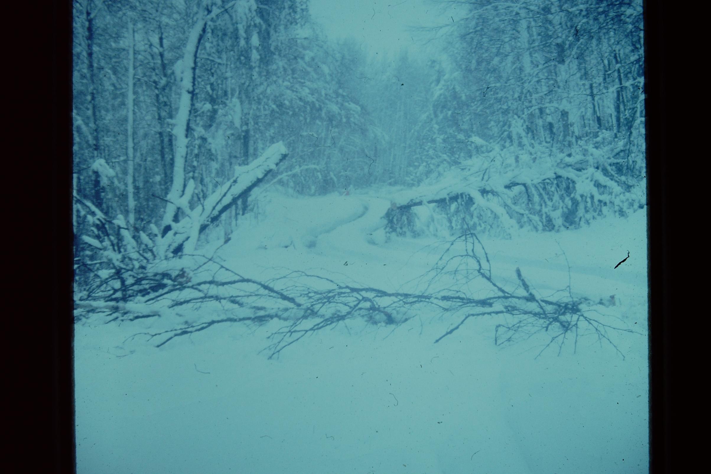
PuffinGin: "Photo taken this morning near Poplar and Birch Lakes on Gunflint Trail & posted on NWS Duluth's FB page"
Thanks for the photo.
Wow quite a dump. If your camping I know like that you got to get the snow off the tent-lot of weight. Yes and NO dry firewood.

10/12/2019 06:37PM
Bushpilot: "Isabella."
Isabella is the highest town in MN with its elevation at the old Forestry Office at ~2001 feet above sea level.
I remember one year in Isabella when I lived there, it snowed October 15th and it never left the ground until Spring.
I just got back from Ely, a little snow there, 3 cars in the ditch on 53, one rolled over pretty good and was on its roof. Lots of rescue vehicles were there, didn't look very good.
May the rivers be crooked and winding, and your portages lonesome, leading to the most amazing view.
10/13/2019 05:12AM
PuffinGin: "Photo taken this morning near Poplar and Birch Lakes on Gunflint Trail & posted on NWS Duluth's FB page
Looks like a wet and heavy snow dumping. Here--in southern Ohio--we had our first frost advisory. :O
“If I have seen further it is by standing on the shoulders of giants.” Sir Isaac Newton
10/13/2019 04:14PM
jillpine: "Pinetree: "Bushpilot: "1 foot of snow on the end of the Gunflint Trail.
"
It seems like this time of year when it snows it is so wet and damp with so much moisture in the air sending chills thru you."
Agree! "
Maybe its just my bones are getting a little older.
10/13/2019 05:05PM
Pinetree: "It always seems if anybody gets snow it is Isabella.
I did hear some spots on the Gunflint got 9 inches."
You are right. I remember January 1994 Finland got almost 50 inches in one storm. The winter of 95-96 the area got 12-14 feet of snow. That was the year in got to about -60 degrees. I was in the area with about 40 guys snowmobiling. It warmed up to -25 during the day.
I am sure Linden shoveled more than his share of snow when he lived in Isabella!
Raised by wolves!
10/13/2019 05:38PM
Bushpilot: "Pinetree: "It always seems if anybody gets snow it is Isabella.
I did hear some spots on the Gunflint got 9 inches."
You are right. I remember January 1994 Finland got almost 50 inches in one storm. The winter of 95-96 the area got 12-14 feet of snow. That was the year in got to about -60 degrees. I was in the area with about 40 guys snowmobiling. It warmed up to -25 during the day.
I am sure Linden shoveled more than his share of snow when he lived in Isabella!"
Yes and Arctic just lives a little south of there.
I also mentioned before in 1977 around Oct. 10th I was hunting moose just south of Isabella and we got 20 inches. Highway 1 there was Jackpines across the road everywhere. Got closer to Ely they got like 3 inches south of Isabella 20 miles a few inches.
 A few feet from Highway #1 on a side road. Highway 1 looked no better and we axed are way thru or zig zaged between trees.
10/13/2019 09:38PM
Wondering if anyone else beside me was out in the BWCA when the 12+ inches of snow hit? I was up the Gunflint Trail on Omega Lake and woke up to a foot of snow covering my tent. I still had 2 days left of my solo trip but decided I better get out in case more came. It was an exhausting 12 mile pack out. My vehicle was the only one in the Poplar parking lot when I got back. When I got to Grand Marais, there was no accumulation at all. Wind all week, a day of full rain and then a foot of snow made for a very miserable 870 mile trip and a week's worth of vacation burned up.
10/13/2019 09:57PM
prizes14: "Wondering if anyone else beside me was out in the BWCA when the 12+ inches of snow hit? I was up the Gunflint Trail on Omega Lake and woke up to a foot of snow covering my tent. I still had 2 days left of my solo trip but decided I better get out in case more came. It was an exhausting 12 mile pack out. My vehicle was the only one in the Poplar parking lot when I got back. When I got to Grand Marais, there was no accumulation at all. Wind all week, a day of full rain and then a foot of snow made for a very miserable 870 mile trip and a week's worth of vacation burned up."
It gets that time of year the weather can be very hot to what you experience. Like you I have experienced the snow and other times dead calm weather and very nice temps and beautiful leaf color. Its the change of seasons,sometimes summer never leaves,others winter comes too early.
10/21/2019 01:10PM
Not white but boy are we getting rain. Needed that like we need a hole in our canoe! Spring is going to be crazy if we get any amount of snow this winter. Lakes and rivers are full! Pinetree, it looks like Brainard has possible flooding? How bad is it?
Nctry
10/21/2019 03:04PM
Brainerd the only major flooding would be south of us at Fort Ripley and just a little around the river. Brainerd itself is on very high sandy ground. Lot of water going south tho.
I will say are marshes and lakes our over flowing and the Mississippi river is at a very high level. Friend fished up the river yesterday and he said boy there is one heck a lot of current.
My house we had 12 inches of rain since Sept. 1 and 1 inch of rain today. Lucky were also on a sandy high ground. In the woods it will be muddy than heck to spring. Farmers going to have to wait until freeze up.
If we have a moderate to a lot of snow this winter and normal meltdown your going to see some super floods downstream.
It would be one cold soggy day camping and water logged firewood.

Subscribe to Thread
Become a member of the bwca.com community to subscribe to thread and get email updates when new posts are added. Sign up Here
Community Links
 Search BWCA.com
 Donate
 Featured Sponsor
