|
 Boundary Waters Quetico ForumTrip Planning ForumSlim to Fat portage
|
 Forum Sponsor

Author
Text
")
03/08/2012 03:19PM
Does anybody know about a portage from Slim to Fat lake? I've been to Fat, but had to go through Slim, Steep and Eugene lakes. I swear I've read somewhere there is a portage out of Slim, saving quite a bit of time.
Thanks in advance, Pete
Thanks in advance, Pete
Reply
Reply with Quote
Print
Top
Bottom
Previous
Next

03/08/2012 03:28PM
peteb,
There is an old, seldom used portage from slim to Fat. It takes off just south of where the little creek that drains Fat enters Slim. There used to be a small pile of rocks marking the portage entrance. I haven't been up that way in a few years so I don't know if the rocks are still there or as to the quality of the portage. I bet if you tried the seach button on this web site you might get some other info.
Canoerone
canoerone
03/08/2012 03:46PM
I've used that portage a couple times. It starts here:
48* 17' 14" N
92* 14' 44" W
and ends here:
48* 17' 31" N
92* 14' 02" W
It's not bad, and I would use it again vs. the option of going up the killer hill from South to Steep. They both climb, but going from Slim to Fat is more gradual and faster, imo.
The portage isn't hard to spot once you leave the L. Loon/Slim portage.
“The more you know, the less you carry” Mors Kochanski


03/08/2012 04:07PM
John & Lynn from VNO did a trip up through there a few years back & describe that portage in their trip report.
03/12/2012 12:12PM
Tried it last year and must have wondered off the path or was never on it to begin with. It was the worst experience I've had in a long time. 2 1/2 hours later of bush wacking, we made it to Fat with a few dozen mosquito bites and cuts on the legs. Looking back I just have to laugh and think we were never on it to begin with.
03/21/2012 11:29PM
Peteb, when are you planning on going?
When we did it, it was in September. A lot less bugs and less heat and it was still a bear, but doable.
Don't know if I would have made it in buggy weather without going buggy myself. :-)
When we did it, it was in September. A lot less bugs and less heat and it was still a bear, but doable.
Don't know if I would have made it in buggy weather without going buggy myself. :-)
03/28/2012 06:00AM
Went from Fat to Slim one time. According to the old Fisher Maps - there is a river. It was more like the thought of a river. Spent the day breaking Beaver dams (one 12 foot high) and floating the canoe through. It was like a series of dams and locks. The last few hundred yards was through swamp. If there is a portage - we weren't on it. Started middle of the morning - ended after dark.
05/04/2012 12:19PM
quote peteb: "Does anybody know about a portage from Slim to Fat lake? I've been to Fat, but had to go through Slim, Steep and Eugene lakes. I swear I've read somewhere there is a portage out of Slim, saving quite a bit of time."
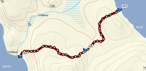
I just got back from there and recorded the portage track with a GPS. The data indicates it's about 256 rods (8/10ths of a mile). The detailed track data can be found at the following link:
Fat to Slim Portage GPS Track
05/04/2012 02:47PM
Nice to see a track of the portage. It'll seem a little longer going the other direction... uphill, though still better than the heart stopping portage at Steep. A little tricky going through that pinch in the rocks while loaded.
“The more you know, the less you carry” Mors Kochanski
05/04/2012 05:15PM
quote PortageKeeper: "Nice to see a track of the portage. It'll seem a little longer going the other direction... uphill, though still better than the heart stopping portage at Steep. A little tricky going through that pinch in the rocks while loaded."
Yes! I know the pinch to which you refer. Coming from Fat is definitely an advantage when considering that slope down to Slim.
I debated back and forth whether to do the Fat/Slim or Steep/South route (I had done neither before). I settled on choosing Fat/Slim to try to save time, but also in my mind were your previous comments about the Steep/South portage. With the conditions of the portages the way they were, I was none too eager to discover that particular one on this trip. It sounds like a doozy. I'll save that for another time. (I just need to be sure to work it so I'm going Steep to South and not the other way around!)
08/03/2016 09:15PM
Hello All-
Just wanted to give a little update. I did this portage about a week ago from Fat to Slim. I'm a little surprised that someone reported it at less than 300 rods, but I suppose it probably seems longer with a canoe on your shoulders. It was is good shape when I did it, plenty of plants to soak your pants with dew, but only a handful of logs to step over, and none that were that difficult to traverse. It took me and my buddy about 30 minutes to do it fully loaded down (Canoe for me, double packs for him). We walked it the day before (fat to slim) in 25 minutes at a moderate pace, finding the trail as we went and clearing some smaller branches/logs. At Slim we heard some thunder, so had a little extra motivation on our way to Fat and made it in about 18 minutes.
BTW, the one of the rangers at the LaCroix station said that it was "better maintained than some portages I've been on in Quetico" for whatever that's worth :).
Happy Paddling!
08/04/2016 09:58PM


been meaning to supply these pics . (june2015)
no rocks cairn for us but with the rock wall on the right and the swamp on the left no place other than this little take out under the trees.
to the best of my memory : false trail down low to left and another to the left up above(found out the hard way) go up to right and kinda stay right at a fork. fairly easy with just packs but with the canoe overhead i missed the turns. was dry for us but an exhausting haul.
08/07/2016 07:47AM
Here's an updated Google Maps track. It looks like Google ended support for direct kmz file references some time back.
Fat to Slim Portage GPS Track
Fat to Slim Portage GPS Track
Reply
Reply with Quote
Print
Top
Bottom
Previous
Next

Subscribe to Thread
Become a member of the bwca.com community to subscribe to thread and get email updates when new posts are added. Sign up Here
Community Links
 Search BWCA.com
 Donate
 Featured Sponsor
