Big Slim
by TuscaroraBorealis
A quick oatmeal breakfast & we were packed up and ready to go.

The portage to Hook lake was just a short paddle south from the campsite. As expected, we had some trouble finding the landing. The location was wrong on my Voyageur map. Clay got out and bushwhacked along the shoreline. The landing (if you want to call it that?) was actually about 50 yards further south down the shoreline. The photo provided shows what the landing looks like from the lake. The trail actually runs just under the spruce tree with the taller dead spire right next to it.
Regarding landmarks, there's nothing that will immediately jump out at you. I can say the landing area seems to be the grassiest spot in the area. Also, there is a huge slanted rock just to the left of the trail. But, it will likely be hidden until you're right on top of it. GPS coordinates are - N 48 01.505 W 092 01.284
Well here we go. The landing is a horrible rocky mess & the grass does a great job disguising their location. After pushing through the tall grass you will actually start to see a trail. It was very wet & muddy. After about 15 - 20 rods the trail opens up to reveal a large beaver dam & the corresponding pond just above it.

It may be hard to discern? But, the trail heads up the left side and follows the ridge the length of the beaver pond before finally pulling away into the woods. Shortly after this there is a narrow passage between 2 large boulders that seemed to serve as a gateway. (At least to me it did)

While there were always trees along the way, the forest was never a thick dense jumble. This created some minor problems when the trail abruptly took an unexpected sharp turn. On a few occasions we kept going straight. But, in each instance, we quickly regained our bearings. Often times there were rock cairns showing the way.

About a third of the way across, I made the determination to leap frog this portage. So I set my load down & headed back for load #2. Clay was compelled to make it to the end, so he continued down the trail.
There was a little of everything on this one. Including an area where the trail seemingly ended at a small pond. Clay found that the water was only about 10 inches deep & the trail was dry again after about 50 yards of wading. In normal conditions this spot would likely just be a muddy area.

Without question the general consensus most people come to is - try to avoid longer portages due to the extra exertion required to complete them. I'm not trying to say I never get tired or sore, but one of the aspects of long portages that I enjoy is the potential opportunity to experience a bountiful variety of micro-ecosystems. And, in that respect, this trail did not disappoint. From walking past a beaver pond, then to decaying leaves, pine duff, muddy spots, a small brook, a few swamps, several granite knobs....there were even some of the scrub oaks that Sigurd Olson spoke of (in "The Singing Wilderness") along the way!
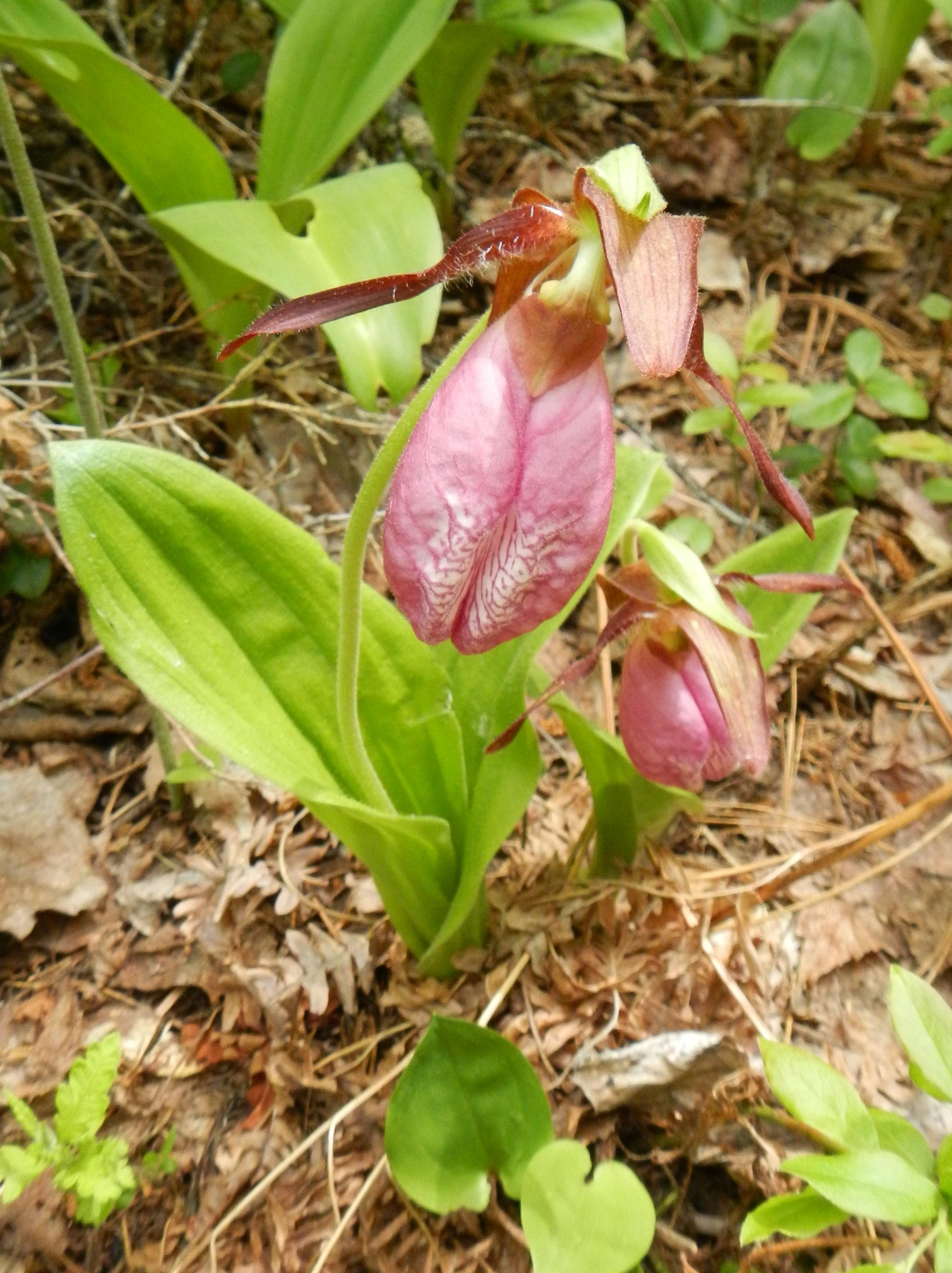
Coincidentally, at one of my drop spots while leap frogging, I happened upon a magical spot. At first I only noticed a few but, upon further investigation, noticed several others as well. In the end, this was the largest concentration of pink lady slippers I recall running across. There were dozens of blooming plants! This helped put some extra wind in my sails for the final push.

A section of the final swamp before Hook lake looked almost pre-historic. It was also the last spot where we temporarily lost the trail. There is a path that continues straight ahead up a gentle rise & leads to a spot that perhaps was the landing at one time when the water level was much higher. (perhaps a beaver dam had given out?) The actual trail veered sharply left once across the swamp.


Even though we employed different strategies for completing the portage, we both had finished within a couple minutes of each other. In the end it took us approximately 2 and a half hours to double portage. A long - tough portage to be sure, but the accompanying sensory pallet overload (sights, sounds, smells) kept our minds off the drudgery of the task.
Took a few moments to catch our breath, then headed out onto Hook. Pre-trip intel was that the campsite on Hook was the cream of the crop in this 4 lake chain. We were hopeful that it was available. Before we got there, as we were rounding the corner to head south, I noticed a yellow sign with a marker just below it.

The sign had St. Louis county stamped on it. Not that I'm hopping up on a soapbox here (as I enjoy running across things like this) but, it never ceases to amaze me how much 'trace' is out here. Even from government agencies! Anyways, the skies were looking a bit more ominous so, after a quick inspection, we pushed on.
As we rounded the horn we could see that the campsite was occupied. Although, with multiple packs open sitting down by the landing, it appeared as if they were either just getting there - or about to leave. We paddled slowly by hoping for a tell tale sign. In the meantime, we admired the impressive rock outcropping directly across from the site.

Since they seemed to be in no great hurry,(nor did we want to pressure them in any way) we decided to paddle over to the Keneu lake portage. The campsite would be visible from the portage so we hiked across, sans any gear, to check the occupancy status of that site.
The trail runs along the base of an impressive bluff. And, before sauntering down the portage, we couldn't resist crawling up to the top to see what we could see. We were immediately rewarded with a nice view back down Hook lake. And, since red pine was the predominant tree in the area, further exploration along the ridge was relatively easy too.

Eventually we worked our way across the portage. It was short & level but, had a lot of troublesome roots & rocks to negotiate. There were also a couple of tight spots where some trees had blown over. But, most fascinating of all was the large pile of fresh bear scat just off the trail.
The Keneu campsite was open. After some short deliberation, we decided to claim it versus waiting on the Hook site. The weather was starting to act up & we figured maybe the people at the Hook site would want to wait it out. And, if we could help it, we'd like to be able to get our camp setup before any rain let loose.
The Keneu site was an above average camp. Red pines dominated the immediate area surrounding the fire grate; which made for a nice airy, yet still somewhat sheltered, site. There were several boulders scattered about which limited good options for tent pads but, made for a really unique fire grate. The spacing of the pines also gave several excellent options for hammock hanging.
Everything was up and we were just putting the finishing touches on the CCS tarp when the rain let loose. Nothing serious, just a good ol' soaker. This was one of those sites that afforded us the rare luxury of being able to set the tarp up in such a manner that we were able to sit under it & stay dry, yet still receive a sufficient benefit of warmth from the fire without having to worry about damaging (melting) the tarp.
Next we put up some wood. Then we relaxed near the fire with our books before supper. After supper the rain eventually quit. We put up a little more wood then just hung out by the fire 'til dark. As we were crawling into the tent for the night, a soft pitter patter of rain started up again. Eventually escalating into an all night soaker.
Big Rice Lake, Hook Lake, Keneu Lake
 Donate - BWCA.com