The historic pictograph route
by TuscaroraBorealis
Today we would push on to our next camp. Weather wise, it started out much the same as yesterday. A quick hot oatmeal breakfast got us going, before having to rip everything down.
Our first leg of the day retraced our day trip (of 2 days prior) down the ‘barrel’ of Gun Lake, where the portage to Wagosh Lake started within eyeshot of the Bullet Lake landing.
This trail was in great shape. There were several sections that were incredibly wide and appeared to be an old road, complete with ruts on both sides. I’ve read that portions of this trail are rumored to have been part of the illegal road that was established in the 1950’s by the resort owners on Crooked Lake to counter the air ban. Once you’ve traveled down this trail, it’s hard to imagine an alternative explanation.
Anyone who has ever read anything by Sigurd Olson knows the essence of his works deal with how a wilderness setting can best help man reconnect with natural rhythms that are increasingly difficult to find in our ever urbanized society. For me, undertaking long portages like this, deep within the wilderness, is a sure fire way to make that connection. Starting out, my only thoughts are of the other side. But, as I traverse the trail, I quickly become transfixed on my surroundings. The far off chatter of a squirrel, birds calling across the forest, the rustling of leaves as the wind passes by, the invigorating aroma of autumn….. In and of themselves, they are all just ordinary occurrences. Yet, somehow in this simple setting, they now all take their place front and center. Each to be contemplated & appreciated with amazed wonderment.

After completing the portage, we thought we’d paddle over to the campsite and take a quick snack break. Upon inspection of the steep landing, Vickie promptly vetoed that idea. Besides, there was a foul stench emanating from the lake; so, instead, we paddled for the Niki portage.
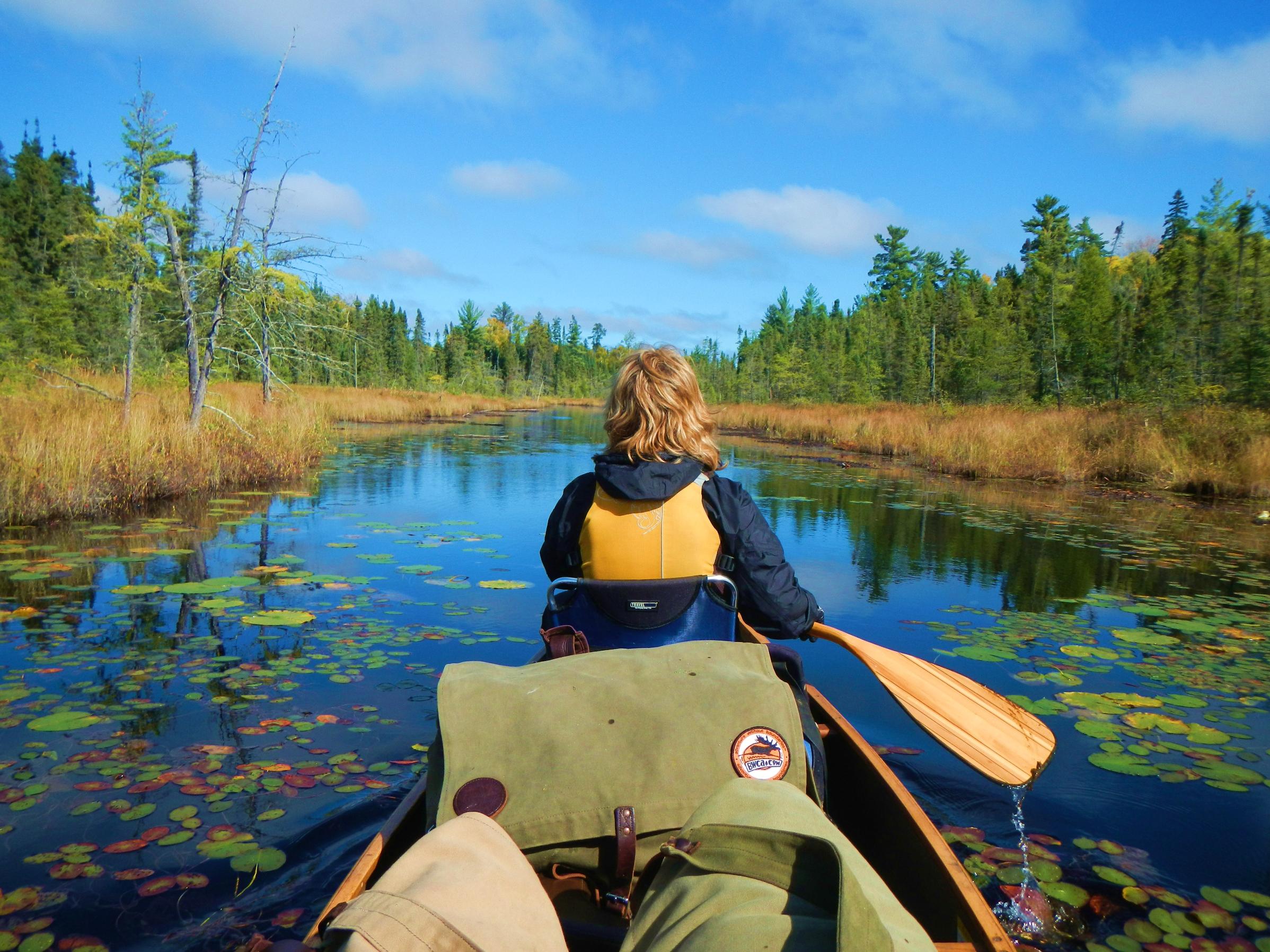
For those that use Voyageur maps, Wagosh Lake is a cutoff point where you will need to switch maps. Out on the lake, I attempted to make this change. I set the new map on top of the pack (half opened) while I folded the old one up. Of course a brisk gust of wind came up and blew the new map into the lake. Before we could recover it, it sank to the bottom. I always carry a spare National Geographic map & Vickie still had hers, so it wasn’t a big issue in that sense. Still, I kicked myself for having made such a rookie mistake.
Crossing the lake, we couldn’t help but notice something bright white moving on the other side of the lake very near the Niki portage. At first we thought it was another canoe headed our way. Soon, we discovered that it was an elegant pair of trumpeter swans. Alas, our inevitable intrusion compelled them to move on before we could get a satisfactory look.

We unloaded the canoe, and stopped for a quick snack break. As we were finishing up, Vickie noticed someone coming across the portage. It was a group of 4 older fellas who told us, in no uncertain terms, that we were definitely heading in the right direction on this portage. As we negotiated the trail, we soon discovered the reasoning for their levity. The trail climbs steeply out of Niki Lake for at least ¾ of this portage. Before parting ways, we chatted some more with our portage pals. Exchanging stories on where we’d been & where we were going. They kindly informed us that we’d simply be able to just get out of the canoe and walk it through a narrow channel at the 3 rod portage just before Chippewa Lake. We wished each other well as we parted ways.
Near the entrance to Papoose Creek, there was an unusual tree with a large ball of branches near the top. At about the same time; another, more familiar, bright ball was also seen after a nearly 2 day hiatus, occasionally poking its head out from behind the clouds.

There was a blanket of lily pads on the water, pitcher plants lined the shoreline, and the water level in Papoose Creek was sufficient for enjoyable leisurely paddling throughout its entire course. Although, as you might expect, it took quite a bit of coaxing to get Vickie to get out and walk through the murky water at the 3 rod portage.
Our final portage of the day into Friday Bay was level, but exceedingly rocky. There was also a mud hole about half way through. Fortunately, we were able to comfortably skirt around this one. After having just paddled a small, intimate creek like we did, Friday Bay was a most imposing site. We were targeting the island campsite near the northwest entrance to Friday Bay. So, after launching, we slowly angled towards the western shoreline as we proceeded up the bay.
Once we passed the small grouping of islands at about mid bay, the wind, blowing out of the east, noticeably began to intensify. So much so, that we paddled past the most direct line to the island just so we could avoid being cross ways in the waves. This way, we could come back towards the island while quartering the ever escalating waves. As we pulled in, I started to notice some pretty good whitecaps out on the water. The landing had looked promising from a distance. But, upon closer inspection, it was rather treacherous when factoring in the pushy waves currently washing ashore. Happily, we were able to unload safely and claim our campsite.
At first glance we were both a bit disappointed with this site. Besides the subpar landing, the fire grate was very exposed and offered no readily apparent tarp options. Once we inspected things a little closer, our opinion softened. Watching the large waves perpetually roll by, no doubt influenced us as well.
By no means was this a five star site, but what it did offer was several exquisitely flat tent pads that were wonderfully sheltered by an enchanting grove of cedar trees. This area also served as a great spot to setup our hammock. There were also trails, begging to be explored, running off in all directions.

While searching for firewood, I stumbled across an old garbage pile. Believe it or not, years ago the accepted practice for disposing of garbage was to just haul it off into the woods. I’ve found a number of these at various sites over the years. Once in awhile there’s some interesting stuff, but everything here was pretty well rusted away. The only thing that was remotely identifiable was a black pepper canister.
It was ribeyes & scalloped potatoes for supper tonight. Save for one last package of bacon, (which we’d have for breakfast tomorrow) that was the last of the fresh meat we’d had along. Since we could now crush the collapsible coolers all the way down, this would free up some extra space which we’d put to good use later in the trip.
For a time, it looked like we might be treated to a glorious sunset. No such luck. The wind did eventually recede a little by nightfall. But, it did continue to blow throughout the night, in time, moving clouds in. Never the less, we once again sat up enjoying the warm crackling glow of a nice canoe country campfire before calling it a night.

Daily travels – 5 portages totaling 501 rods.
Gull Lake, Gun Lake, Wagosh Lake, Niki Lake, Papoose Creek, Chippewa Lake, Papoose Lake, Friday Bay
 Donate - BWCA.com