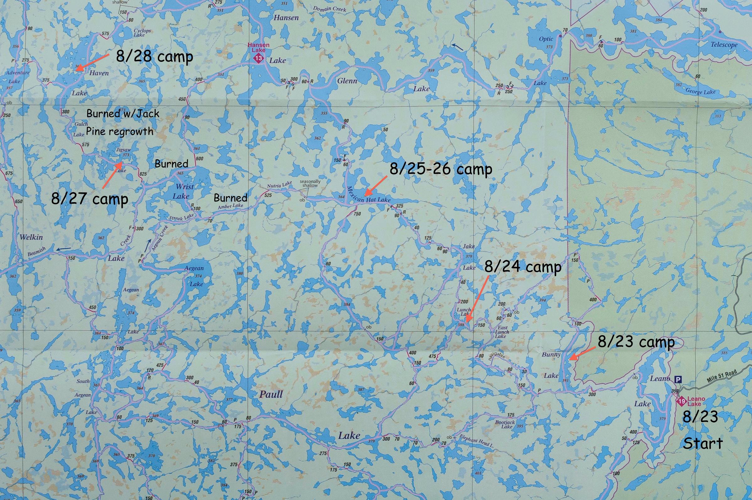
WCPP 2015 Leano to Haven
by Ausable
My friend Tim and I started our trip from La Grange, IL, about 3 PM. We arrived at Rice Lake, WI, about 6 hours later and stayed overnight in a hotel. After a quick breakfast, we got on the road around 6:30 AM for the trip to Red Lake, ON. The drive would take 10 hours. We arrived at the border crossing at International Falls around noon and entered Canada rather quickly. As we drove through, we noticed that the line to enter the US was long; we noted this fact for our return trip.
We bypassed the fast food restaurants that are located rather more conveniently in International Falls than in Ft. Francis, hoping to find a place to eat driving east from Ft. Francis on route 11. We stopped at a large gas station convenience store less than a half hour later. That store had a great selection of fishing rods, reels, and lures. We continued east and turned north on route 502. Not too many miles north of the 11/502 intersection, we saw a small black bear in our northbound lane; he looked at us for a few seconds, turned around, and disappeared into the woods. The rest of the trip was uneventful until about midway up route 105 when the skies opened in a torrential thunderstorm that just went on and on. We later learned that it was a record rainfall.
We arrived at Red Lake Outfitters around 5 PM and met with Harlan Schwartz briefly. He told us that he had 10 flights backed-up because of the storm. We went to dinner at the “best” restaurant in town (recommended by Harlan); it was upscale Italian and the food was good. After checking into the hotel, Harlan met with us there around 8 PM. We discussed possible alternative routes because the weather report indicated that flying on Sunday looked unlikely. Not only was the weather predicted to be rainy, but there were still those other clients in the queue ahead of us.
Day 1, Sunday, 8/23/2015
We decided to travel from Leano Lake (pronounced Lee-an-o) to Haven Lake and fly out of Haven next Saturday (weather permitting). The plan reversed our original route and it involved some risk in that we had no guarantee about Saturday’s weather, although the prediction looked OK. After breakfast, we went to Red Lake Outfitters to pick up a 60-liter barrel, a satellite phone, and the canoe. Harlan had marked-up two maps for us and we discussed route options with him. We left on a van shuttle with two other people around 10:30 AM. It was raining and the bottom of the clouds looked to be at less than 1000 feet: planes would not be flying today. The people riding with us would be traveling south out of Leano while we would be going west.
The rain continued all day, it was miserably cold, and the northwest wind was strong. We estimated that the wind speed was 17 to 21 knots. Taking breaks as needed, we paddled to Bunny Lake, traversing a beaver dam and one portage, and stayed there. We camped on a point halfway up the lake on the east side. The point was exposed to the north wind, but we found a lower place on the south side that afforded us some shelter from the wind and rain so that we could cook dinner. I don’t remember what we had for dinner, but it was hot and filling. While I prepared dinner, Tim managed to get a fire started in the fire ring up on the exposed point: that was a challenge, to say the least. It was so cold that evening that I had to put on my long johns with 2 pairs of socks and fleece jacket, we closed up the tent, and I cinched the sleeping bag so that only my nose and mouth were exposed. I pushed my 45°F bag to its limits and then some.
Day 2, Monday, 8/24/2015
We packed up wet after a breakfast of oatmeal and coffee. Although the rain had lessened from Sunday, the day was just as cold and windy as before. The daytime temperature may not have been much above 50°F. We paddled and portaged (5 portages) to Lunch Lake. The campsite had about one inch of topsoil, so we had to use large rocks to stabilize the tent. The sun broke through the clouds late in the day and the wind diminished to a slight breeze out of the northwest. We had hot tea and coffee to help us warm up before dinner. Dinner was Mexican rice and beans with chicken and tomato sauce. Afterwards, we went out to fish the lake’s bays to the north. We caught nothing, but the sunset was nice and the stars were bright. Tim made a roaring fire and we tried to dry out our socks on the rocks around the fire. It was another very cold night: I hoped that a pattern wasn’t developing.

Day 3, Tuesday, 8/25/2015
When I got up in the morning, I found that a mouse had eaten my wool socks that I had left out to dry under the tent’s rain fly. It was good that I had two other pairs of wool socks. Lesson: leave socks on the clothesline or put them inside the tent. The morning was cold and sunny. We were traveling to Mexican Hat Lake today. It was a great day for traveling. We left our camp around 8:20 and trolled through Lunch Lake going north. The line got snagged; when we got it free, the lure caught a small pike (foul-hooked). We surmised that the pike might have gone after the lure at the same time as it popped loose.
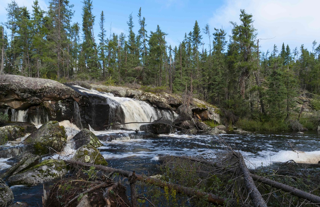
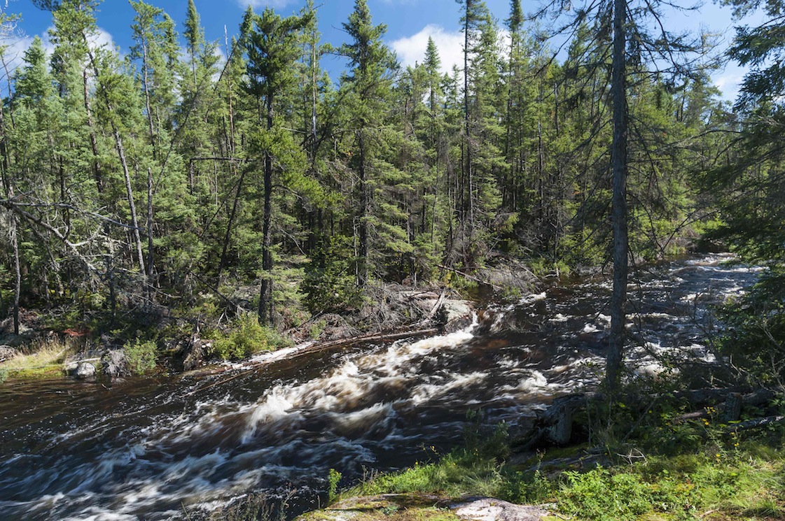
There were 8 portages on the route, most of them around pretty falls and rapids. The falls on the north end of Lunch Lake were gorgeous, but the take-out was less than 10 feet from the drop (about 20 feet) – not the safest location. In fact, several of the portage trails this day started much too close to either falls or rapids for my comfort. Tim tried fishing at the base of the falls, but the fish, if there were any, were not biting. I spent some time photographing the falls. The trail was often in the middle of a stream, probably because of the record amounts of rain over the previous 3 days.

We were tempted to run one rapid out of Jake Lake, but we walked the whole portage before committing to it. The bottom had a drop and a hole and a strainer across the entire width of the stream – a killer.
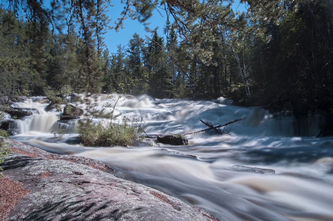
The last set of falls for the day were into the east side of Mexican Hat. The portage was supposed to be 325 meters long. It was easily the toughest portage so far. At the top of the falls, a portage crew had placed floating logs as a kind of bridge, but they were not tied together. Both of us fell through the logs. The trail itself was very narrow and the footing was treacherous. The high water surging alongside and over the trail in spots made the portage even trickier. Both of us carried the canoe bow and stern for safety, the only time we did that all week. The rapids & falls at Mexican Hat are powerful and the total drop is very big. The drop seemed much larger than the difference of the lake levels that were printed on the map. The landing at the base of the falls is really steep and is a slick granite slab.
People were camped at a site across the river at the base of the falls. It is a noisy location. Tim tried fishing at the base of the falls: no luck. About halfway across the lake, we met a man and woman who were paddling towards the falls. They had no gear, so they must have been camping at the falls. We checked out 3 campsites, but we doubled back to choose the first one that we had investigated. We got there around 2:30 PM. We and the couple at the falls were the only people on the lake.
While we were on the north end of the lake, we heard a strange, other-worldly, multi-toned whistle. We wondered whether it could have been a caribou or a moose. At our camp, which was on a peninsula in the middle of the southern part of the lake, we heard Sandhill Cranes.
We were tired after a long travel day, so we did not go out fishing, although Tim did some casting from the western point. We spent time relaxing, washing clothes, etc. Our dinner was a chick pea curry with shrimp. While we were preparing a fire, we noticed a mouse trying to sample some of the food scraps that we had tossed into the fire pit. The sunset was beautiful. The stars were brilliant. Although the day had been warm, it was another cold night.

Day 4, Wednesday, 8/26/2015
This was our layover day, so we took the time to make pancakes for breakfast. The morning was cold and sunny. We decided to try fishing around the island to the west of our camp. We had met a family during a break on the ride to Leano Lake who had camped on the island and found that the fishing was good in the immediate area. While we were jigging and casting plastic grubs for walleyes, Tim caught a 23-inch lake trout on the north side of the island. He put it on a stringer to keep it for lunch while an eagle circled overhead, perhaps wondering whether he could make a play for our fish.
We paddled around the island to the stream on the south shore, but the area was too shallow to hold fish of any interesting size. We tied up the canoe and walked up the portage path alongside the stream until it crossed the stream above the rapids at the top of the hill. The total drop to the lake below was about 30 feet. The map shows the total portage to be 750 meters long; we probably hiked about a third of that distance. We found what was probably caribou scat along the trail. I also saw what looked like Joe Pye Weed at the place where the trail crossed the stream. We also saw blueberries along the trail.
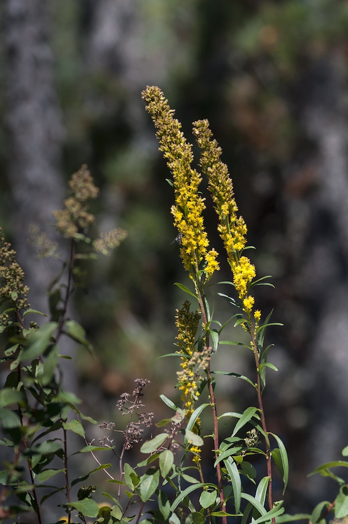
Tim built a fire so that we could bake the trout for lunch: it was very flaky with a wonderfully mild flavor. We rested that afternoon. A south wind picked up with some high clouds coming in. We saw and heard a V-formation of about 50 Sandhill Cranes fly overhead to the west. There were lots of animals around the camp: ravens / crows, red squirrels, chipmunks, small birds, seagulls, an eagle. Tim found more caribou or moose scat near camp. There was goldenrod (and at the top of the eastern falls into Mexican Hat), some wild rose, an unidentified plant bearing red berries (maybe baneberry), common juniper evergreens bearing blue berries, and bunchberry is abundant everywhere. The trees here are birch, Jack Pine, and spruce. The sunset was golden and wonderfully tranquil.


Day 5, Thursday, 8/27/2015
I got up around 7 AM due to sheer laziness, I suppose. It looked like it would be a nice day. Breakfast consisted of oatmeal and rehydrated blueberries. We got on the water around 8:30 to travel to Jigsaw Lake. There would be 5 portages (in order): a beaver dam, 525 m, 70 m, 100 m, 825 m.

We had to remove the gear pack and food barrel at the beaver dam because it was too high to pull the canoe over with all that weight in it. At least we were able to get the canoe parallel to the dam. That put us into small Nutria Lake. The 525 m portage started at the west end of the lake in a beautiful spot. The high ridge to the north looked like it might have had a fire go through it some time ago. The portage was really tough: long, boot-sucking mud, steep elevation changes, slippery footing, floating logs. At the other end (Amber Lake), it was immediately obvious that a fire had gone through recently. There was not much regrowth. It looked more and more barren the further west we paddled. We had never traveled through a burned area before.
The next two portages were into and out of Streak Lake. They were easy. Streak was thoroughly burned very recently on both sides. On the portages we saw small understory plants and flowers regrowing. We also saw what I later identified as Black-Backed Woodpeckers. They had solid black backs and heads with white faces and bellies, and they were maybe 8 inches long. They had a very distinctive call, unlike any other woodpecker I’ve heard. Tim saw a flying, black, long-horned beetle at the portage landing on Wrist Lake. I was later able to identify it as a White-spotted Sawyer Beetle; it is native to the continent.

All of Wrist Lake has been burned, but it must have been some years ago. Jack Pines have started to regrow, but we were in a hurry to get to Jigsaw and I didn’t get a close look at the landscape. The portage between Wrist and Jigsaw is very tough. It was hard to find, but someone had marked it with two pieces of pink surveyors tape wrapped around a burned tree. The trail was marked by cairns and tape. The trail had tough elevation changes, some treacherous footing on loose rocks and granite slabs, and it ended in a floating bog (that was interesting). The day had become hot (maybe 80°F) and muggy and we were constantly exposed to the sun because the Jack Pines were only 4 to 5 feet tall. The portage was exhausting. Travel time was 20 minutes one way.
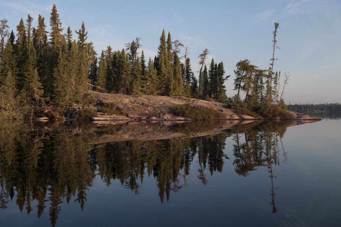
You have to keep your mind focussed on the map, compass, and landscape when you are on Jigsaw. The lake is aptly named: it is a maze of small islands and the shore holds very few clues to your location. Fortunately, Tim is an excellent navigator and I had a GPS. We looked at all three camp locations that Harlan had marked, but the only one that we could find was the camp in the middle of the lake. The whole lake and its surrounding shore has been burned (later, Harlan told us that it had burned 6 years ago). The Jack Pines are growing uniformly 4-5 feet high, and they are a dense mass at this point. It would be nearly impossible to find or create a camp except on a bald granite slab. Our camp consisted of an exposed granite slab. There were no trees from which to hang a tarp. However, there were many loose rocks that we were able to use to anchor the tent; that was good. The lake’s terrain is low; the maximum elevation might be 20 feet above the lake’s level. Jigsaw Lake is shallow: we found that the maximum depth was no more than about 15 feet, at least where we fished.
Dinner was corned beef and mac and cheese; one could taste both; not bad. We went out fishing for walleye after dinner. We started fishing about an hour before sunset. It was nice to get away from the mosquitos and there was a light breeze, so the canoe drifted. It was very, very pleasant. Although the night air became chilly in the boat, it was still warmer than previous evenings. I caught two walleye in the 14-18 inch range. We caught them in the channel just west of the camp. The bite is subtle and they seemed to take the bait on the drop (3-inch white Berkley PowerBait grub; ¼ ounce Eagle Claw walleye jig head).

Day 6, Friday, 8/28/2015
We got up at 6:30 with a very light rain falling. There were some dark clouds in the south with breaks in the clouds to the west. There was a south wind. We ate quickly – trail bars and coffee – and packed up quickly in an increasing rain. Finding the portage out of Jigsaw was tricky. There was nothing marking the portage except some trampled vegetation. It was another tough portage (575 m), similar to the portage into Jigsaw. Because of the steepness of the descent and the slipperiness of the wet granite, both of us were required to get the canoe down the last 100 feet to Gulch Lake to avoid a potential injury.
Gulch Lake has also been burned and is experiencing the regrowth of Jack Pine similar to Jigsaw. There are higher banks and cliffs on Gulch. The rain had stopped so we could take off the rain gear. That was a relief because we were sweating under the rain gear on the portage. The strategy for both portages into and out of Jigsaw was to take packs over first to both reconnoiter and assess the state of the trail. Even though there are cairns on the portages, one can miss them and get off the trail.
The last portage this morning was 300 m and was mostly level along a stream. It started to the right of an old beaver lodge and ended in the south end of Haven Lake. We slopped through some mud and water and on/around the various logs placed by a portage crew. We had to negotiate a portion of the trail that was only 6 inches wide along a cliff: this was bad and the rock was wet and friable. I slipped with the equipment pack on, but I recovered OK although the camera case banged against the rock. The second time through I fell in the same spot, banged my left knee pretty good, and missed being impaled by a sapling stump by about 6 inches. The knee was pretty painful for about 10 minutes, but at least I wasn't seriously injured. Thanks be to God for His protection!
At the landing on Haven Lake, we could see mature trees as we looked north and rejoiced! We were tired of the burned areas. The southern third of Haven has been burned on both sides and is regrowing Jack Pines. The camp sites that Harlan marked were in the mature zone. We found a decent site on the north side of the mid-lake peninsula. We arrived around 11 AM. We hung out, rinsed out clothes, took pictures, read, etc. Loons were on this lake. There was caribou sign near the camp. We had to use rocks again to stabilize the tent.
We went fishing for walleye after dinner. Tim caught one walleye jigging off the southern tip of the island to the east of the peninsula, and another trolling through the channel. A huge cumulonimbus cloud formed in the northwest and moved over us. Cirrus clouds were also moving fast. The setting sun lit the clouds with a warm light. We ended the night with a fire and tried a photo experiment with the tent and the full moon. We saw the stars before we went to bed at 10 PM. It was a fairly warm night, so we left the tent open.

Day 7, Saturday, 8/29/2015
This was our last morning in the wilderness. It was a lovely, blue-sky day. We took some time-lapse videos with Tim’s camera. A De Havilland Beaver flew over us going east to west around 9:30. We met the pilot later in the day at the Viking Air station. He had flown a party into Adventure Lake, which is just to the west of Haven.
We left the camp around 10 AM, trolling northward, and caught a walleye. We tried jigging in several places without luck. We found out later from Harlan Schwartz that some Red Lake fishing camp guides had found that the “bite” was not good during the week that we were in the park. The weather conditions (heavy rain followed by cold and then heat) were the likely culprit. We grabbed a quick snack on the eastern side of the northernmost island at 11:30 and waited for our plane. It flew in around noon.


The plane circled over us and then landed not far from our location. The pilot turned around on the water and came back to meet us. It was really exciting to see the plane come in. We paddled out to the plane and the pilot met us standing on the left pontoon. We climbed the short ladder from the pontoon into the cabin and the pilot handed the gear up to us. He then tied the canoe onto the top of the pontoon. The flight from beginning to end was so exciting and “cool”. Neither Tim nor I had ever done this sort of thing and it did not disappoint. It was amazing to think that we were flying in a plane that had been built in the 1950’s. We took lots of pictures on the way back to Red Lake.


 Donate - BWCA.com