2017 Kruger Challenge - as told by Muddyfeet
by muddyfeet
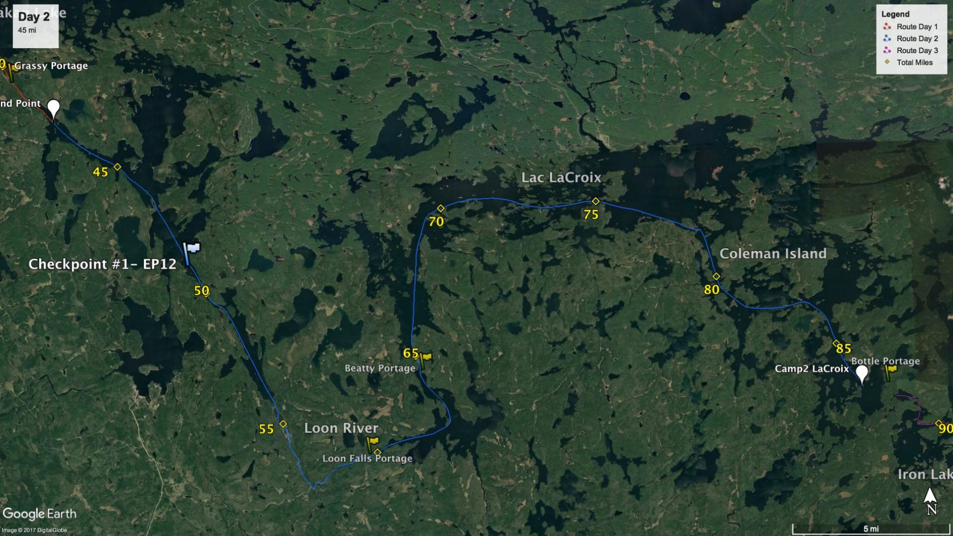
Up early to break camp and get on the water in the dark before 6. I was excited to get going and couldn’t get my oatmeal and coffee down fast enough. I watched the sun rise over the glassy water in front of me as I paddled Sand Pont Lake amongst a few early morning fishing boats. Just before entering the narrows, it disappeared behind a high veil of clouds and would stay hidden most of the day. There was a little wind on the open reaches of sand point, though it was not noticed at all after I passed the narrows into the BWCA. I sent a message for the checkpoint and cruised on.
The Loon River was narrow- not more than a canoe length in places- and was well protected from any sort of wind. I was going against the current, but it was so slight as to not be detectable. It was serene paddling- aside from the motorboats. This was the motor route to Lac LaCroix, and not only did fishing boats zoom past every 20 min or so, but 200hp Outfitter boats with 2-5 canoes on top shuttled less-adventurous paddlers to-and from- LaCroix and beyond. It dawned on me that most of these people who didn’t like to paddle far were being dropped off on the east end of LaCroix at Bottle portage, where they would walk a single portage to camp on Iron Lake. [Last year I had visited Iron Lake in the fall and remarked that it was very crowded with heavily-laden canoeists who must have had a heck of a time bringing in all that stuff. It only made sense now- they were motored in.] 10 hours from now this knowledge would influence my decision to not search for a campsite on Iron Lake.
There is one portion of the loon river where the banks widen, and the depth shallows out to allow reeds and grasses to grow. The channel (and the international border, if you look closely at the map) zigzags back and forth from side to side. Of course I had that marked on my map and I dutifully followed the natural sinusoidal path through the weeds. Only after making the first curve did I realize that the motorboats had cut their own channel straight through the center of the weeds in a direct line. Huh, I didn’t see that on satellite images: I guess it would save time to follow that. All fine until a heavy outfitter boat catches up behind you and there is nowhere to ‘pull over’. I parked the canoe off the channel in the weeds to allow the boat to pass, and it did so very slowly as it was quite shallow. The heavy vee hull made a tremendous wake, and not wanting to miss an opportunity, I pulled in behind the slow moving boat boat to take advantage of some of the waves. The outfitter clients were sitting in the back of the boat taking photos of me as I kept the canoe riding the the wake for 50 yds or so, until the boat sped up and pulled away.
There are only two portages to cross all the way from Sand Point Lake to Lac LaCroix- and the motorboats have to cross them too. They are mechanized portages which each contain a very unique marine railroad- the only ones in the BWCA, and only to allow the motorboats (for a fee) to get to LaCroix. Sets of rails climb out of the water and up a hill over into the next lake. A winch house is located at the top of the hill. It pulls by cable a single car on the rails that has a ‘sling’ for boats to sit in as they are moved. The boat parks over the car, to be lifted out of the water much like the act of landing a boat on trailer. It is winched up the hill, and down the other side to be deposited into the next lake. Of course there is a traditional portage trail, too, where I carried my pack and canoe.
Out of the narrow river, I knew I had a lot of paddling ahead. I paddled the bays of Loon Lake and ascended up into the northwest side of LaCroix- with only a gentle northeast headwind. I primarily paddle a fast sit-and-switch stance, but it was here that I figured out a kneeling posture to give an occasional break to my hindquarters; sore from hours of sitting. My boots would not fit under the seat: I would take them off and kneel on the neoprene uppers, placing my seat pad on the hull beneath the seat to rest my feet on. Even my feet had to be fully extended to fit under the seat, and I could only go a mile or so before they would start to get all numb and tingly. That was all the rest my backside needed though, and I could do this every hour or so before clumsily trying to pull my numb feet back into a seated position while not capsizing the boat.
I had never been on Lac Lacroix before, and I was amazed at its beauty. The northern US/Canada border is dotted with hundreds of tiny islands: bits of boreal forest and twisted pine crowning floating rings of migmatite rock. I had an ideal route mapped through the maze of islands, and navigation was not easy, but the landscape was amazing. There were a few quiet cabins and boathouses on the Canadian side, but I didn’t see another person or boat as I paddled the labyrinth on the northern reaches of the massive lake. I made a mental note that I’d like to come back here another time to explore a bit more.
One more open crossing before turning south to the Coleman Island cutoff: about 3 miles of exposure to a gradually building northeast wind. I pushed, and was tired when I made the narrows 45 minutes later. The weather was changing. If there is one thing I know about predicting weather in this part of the country, it is that nothing good ever comes from an east wind. The mostly-overcast/partly sunny day was over, and my parting view to the northern basin of LaCroix showed darker clouds building. It was only 3pm and I kept moving on. I may have heard muted thunder far to the west, but not sure. By the time I passed through Fish Stake Narrows, the wind was up, and it wasn’t behind me. The gusts were more frequent, and at times it was a struggle to keep the boat on course. I could see weather coming in from the west, and with Bottle Portage coming up, I was guessing I would be somewhere on Iron Lake by nightfall. I was physically low on gas, and mentally grappling over whether of not I should stop to camp- even though it was only 5:30 and I still had daylight left. I made the decision to check the last campsite on Lac Lacroix. It was on an island facing east and while it was within visual sight of Bottle Portage, it was somewhat protected from the wind: now gusting from the north. If it was occupied, I might have been tempted to push on and try my luck on Iron, but there was nobody in sight, and I somewhat reluctantly made an early camp here. I wasn’t feeling great: and was beating myself up for stopping early.
It turned out to be a good decision. The increasing wind continued to gust as I pitched my hammock and tarp- taking care to think about how it soon may be needing to shed significant weather. Protein shake, dinner, pump water, and while it was still light out I climbed into the hammock: setting my clock for an early start to make up for it. Despite the wind, I must have fallen asleep instantly. I also slept well, with only vague recollection of the storm that raged soon after I closed my eyes. When it hit I was dry and warm and sleeping, rather than paddling and searching for shelter. I would later find out that I was on the northern edge of a severe warning area.
45 miles today, and almost 90 in the past 35 hrs.

 Donate - BWCA.com