2017 Kruger Challenge - as told by Muddyfeet
by muddyfeet
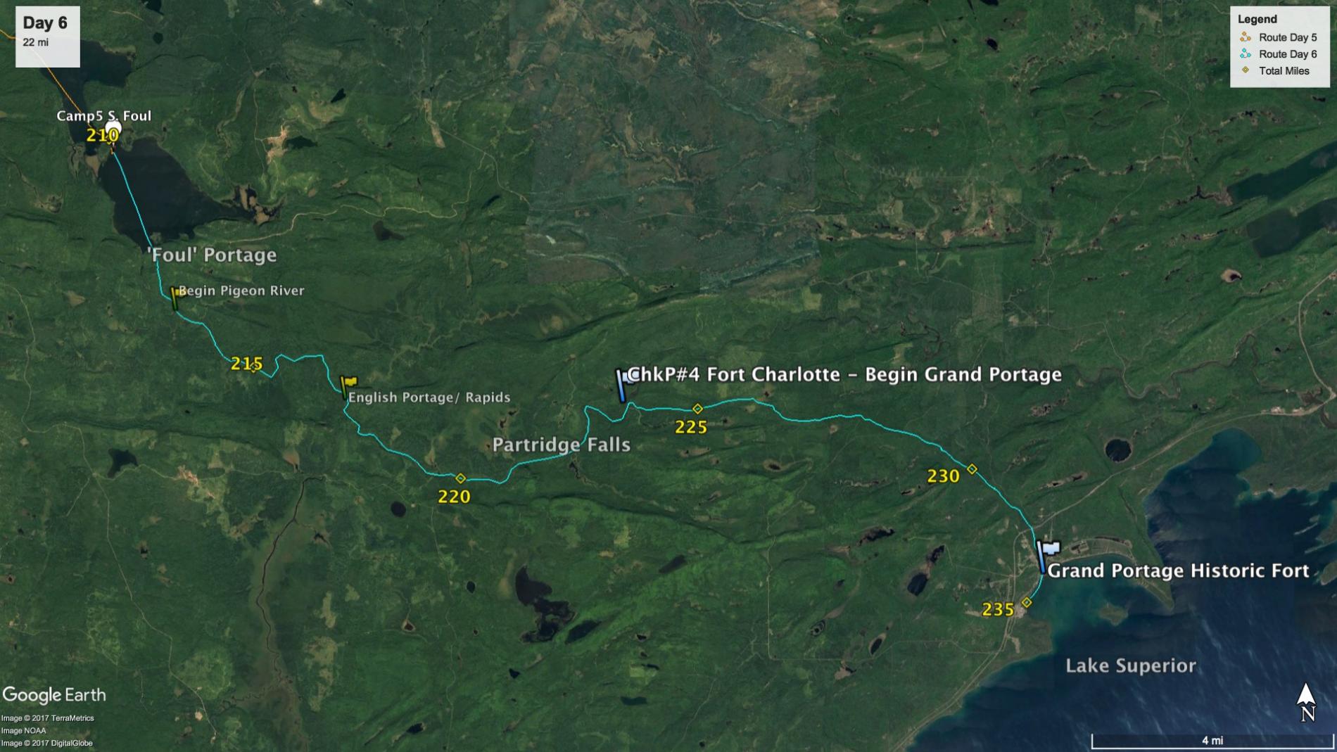
I woke to pouring rain against the tarp and it was an easy decision to snooze in the warm and dry hammock another hour until it slowed: I knew I had plenty of time to finish the challenge today. I enjoyed coffee and a hot oatmeal breakfast under the tarp, and I packed for the long walk that would define today’s travel: consolidating the daypack and as many things as I could take off the canoe and stuff into my main pack. The irony is that for all my efforts packing lightly and even ditching food weight, the majority of my gear was soaking wet and in the end probably weighed close to the load I had started with 5 days earlier. Lightly raining as I left camp. A short few minutes later I was at the Fowl portage, and thus off my maps.
This mile-long portage on the Canadian side would later come to be known as the “foul” portage. I likened it to attempting a ninja warrior course while carrying a pack and canoe- in the rain. First a climb 80 feet up a slippery talus slope, then a surprise fork in the trail. No signage, though looking closely showed that there were two birch sticks perpendicular across the left fork trail in a loose x. This was very subtle and not noticeable unless you’ve encountered something like it before and knew that it was not natural. Someone had marked it as a spur and so I took the right fork. I remarked to myself how I just blindly trusted whomever had put it there, but took some comfort in the reasoning that anyone who would actually be on this trail would be the kind of person I would probably trust. Hedging my bet, I clicked on the gps 100 yards down the trail to confirm that I was indeed generally heading in the right direction. The next obstacle was more than thirty down trees at waist height (wet) to climb over without tearing my pants or dropping the boat. There were two that required getting down on my knees to crawl under. Once that ended, the trail reached the lowland of the river and the mud started. Almost knee high in places and unavoidably spanning the width of the trail tree-to-tree.
After the slowest mile-long portage I can remember doing I reached the Pigeon river. It was a 15yd wide river with gentle current that wove past tamarack swamps and sedge grasses. I saw many beaver and white trumpeter swans here and flushed numerous ducks from the grasses lining the bank. There were a couple obvious moose trails leading in and out of the water but the large animals weren’t to be seen.
My concern on the river was that there was three shallow rapid sections that I was warned would put a new layer of scratches in my canoe. On top of the list was a section labeled on USGS and historical maps as the “English portage”. However, I had talked with several others who had in the past few years spent considerable time bushwhacking the banks only to conclude that this portage no longer existed and that the best route was to navigate the rocky river itself. The first rapid section was short and mild, and I bounced on a few rocks and had to dismount the canoe once to float it over a shallow part.
A while further and I was upon the English section, which started out with a much steeper river drop through larger obstacles that included a few good standing waves. No doubt I relied on previous river paddling to read the situation 20 yards in front of me and weave the canoe in-and-out of boulders, trying to keep it in the cleanest water through the rapid. Because the preferred lines were much more visible in the deep fast water, I thought this to be easier paddling than the shallow, slower riffles that made up the next half-mile or so. It was then a cringe-fest as I heard and felt the newly refinished bottom of my canoe snag on sharp rocks just waiting to eat Kevlar for lunch, and I was also forced to dismount once again to navigate a tight spot.
The river then leveled off to slowly wind around some hills and ridges for a few miles. The next portage would be around Partridge falls: a towering 50-foot cascade that, in contrast to the nonexistent English Portage, is not marked on any map. This is ironic, because to accidently go over this falls would likely mean death. Thankfully, you can hear it long before you approach the drop, and there is sufficient slackwater to easily land at the portage. The muddy bank climbs to a jeep trail leading down the hill along the river, and you have to almost guess at the right spur leaving the doubletrack to get you back to the water, but I had no trouble finding the right way. There is supposed to be a nice overlook right at the falls, but I had the finish on my mind and didn’t stop to check it out.
A couple easier river miles and I reached Fort Charlotte and the start of the Grand Portage. There was a log dock landing and I took my time reading the sign describing the history and archeological significance of the site. Bonus: I always thought it was a 9-mile trail, but in 2-inch engraved letters the sign clearly said 8.5 miles to the trading fort. I filtered water one last time and hit the trail around noon. There are a few muddy streams and beaver swamps along the Grand and it was certainly wet enough that they would be running, but not anything you would want to rely on for drinking, and I quickly planned a water rationing strategy. 8.5 miles lay ahead. I would bring 1 liter and drink roughly 200mL every 1.5 miles.
The two-mile Rose portage the day before had been tough, so I thought it wise to stop and set the boat down for a five-minute rest every 1.5miles. This ended up working well, and I was surprised at how new I would feel after even a brief rest without canoe or pack on my shoulders. I had a run tracking gps app on my iphone (that I often used when training) that would audibly call out splits. I set it to notify me every half-mile to keep track of where I was and avoid the mental anguish of a seemingly endless portage.
The trail went past two unoccupied campsites with elevated tent platforms near the river and then took a gentle and wide path into the forest. Six feet wide to be exact, and cleared very well. I kept seeing pieces of red twizzlers liquorice on the ground, and would later find out that there was actually a parks crew that had cut blowdowns and weed-whipped the entire trail less than a week earlier. The liquorice was in fact broken pieces of trimmer string. It was very nice not having to dodge down trees and it made for a fast pace; when not resting I was able to walk bet 2.5 and 3 mph. The terrain was rolling, but I knew there was an overall drop of 600 or so vertical feet down to Lake Superior. The wet conditions held plenty of mud on the trail, but with calf-high boots the best option was usually to barrel straight through the mud sections focusing on balance alone- and I ended up dirty, but fine. There was perhaps two dozen or so sets of short board walks through swampy ground, which consisted of elevated 12”x 3” planks laid end to end. The trouble, though, was that most of these were shaded under heavy tree cover and kept in such perpetual dampness that their topsides were tinted green with mildew and algae that was deadly slick. After a few near-falls I learned quickly there was more reliable footing walking beside the planks when possible- even through ankle sucking mud. The pack soon began to show its insufficiency at keeping weight at my hips, and with maybe 70lbs of both pack and canoe bearing down, my shoulders would be screaming before every 1.5 mile rest. Food and water were managed well, and the phone app kept me motivated to keep at pace. I could feel the hotspots on my feet, but wouldn’t realize until later that night how large the blisters actually were. There was mixed rain showers and sun, and the humidity was way up. I drank the last of my water and spirits were high as I passed 8 miles after about 4 hrs of portage. The phone reported 8.5 miles and the fort was not in sight. I crossed a paved road and still no fort. Crossed Hwy 61 and still no fort. Now this trail was actually endless.

Suddenly I came out of a clearing and saw people waiting. GrandmaL and BeaV were there with cameras, and my mom and uncle who had unexpectedly driven up to greet me at the finish. They took photos as I walked through the fort stockade and I sent a final Inreach message to document an official finish time. Just as I put down the canoe and pack on the fort lawn the phone chimed with a GPS distance of exactly 9 miles.
Instantly I felt awesome. Congratulations and muddy hugs were given all around. The fort was still open and there were a couple living history reenactors who greeted me as well. I was told of a ceremony for newly hired Voyageurs who after their first season traversing the Grand into the interior would be voted upon by their peers. If they proved themselves an asset to the rest of the brigade they would be deemed true Hommes du Nord, or Northman, and given opportunity to paint their paddle red with vermillion. For my 5 1/2 day crossing I was presented with a ceremonial red paddle and more photos. I was sure to warn the park staff that should I ever return to Fort Charlotte, I may find it necessary to deface the sign to accurately state the 9-mile distance. To complete the journey I carried the canoe down the bank to Lake Superior and paddled 400yds south to the marina. I said thanks and goodbye to my family, stashed the canoe behind the marina office, and gladly took a ride to the casino hotel to see if there was a room available.

After a needed shower I enjoyed the wonderful experience of putting on dry clothes. I assessed my feet and drained a half-dozen blisters. One was under enough pressure that when I poked it, the blister fluid actually hit the ceiling. Gross. I hobbled down the hallway to meet GrandmaL and BeaV for dinner and beer, and another beer. And another, as we regaled with stories of the past week. BeaV was a whole day ahead of me and had set a solo record for the course at 91 hrs. At one point it was suggested we have another round, but we had somehow missed last call and found ourselves too busy to drink- talking late into the night.
 Donate - BWCA.com