SE Quetico Solo 2002
by sedges
Prologue
The country of lakes and rivers, rock and forest and bogs north and west of Lake Superior is my spiritual home. Early in my life the trails of that place and the people I shared them with guided me to be the person I am today. They started me in a good direction and each return to the canoe country helps me to reorient and recover that direction. I now live in the foothills of the ancient Appalachian Mountains, far from the lake country. I do not need to live in my spiritual home; there is a connection to that country that runs through all facets of my life. I am thankful that I am able to return as often as I do.
On my first BWCA/Quetico trip in 1968, I kept wondering what it would be like to travel that country alone. On the many trips that followed I enjoyed the companionship and cooperation of the groups I traveled with, but I knew I needed to try it alone, just to see how it would be different. Some recent trips have been with a single companion: Sue, my partner, or my father on his last trip. This experience was different. Decisions about camp routine and travel are easier to make with only two people. We felt a greater sense of freedom and solitude. I often work in the mountain forests, alone and in a wild setting. Frequent solo backpacking tours in the country south of Lake Superior in the 1970s and in the southern Appalachians in the 1980s gave me a taste of solitude in the bush. It is time, in my 51st year, to do that solo trip in the canoe country.
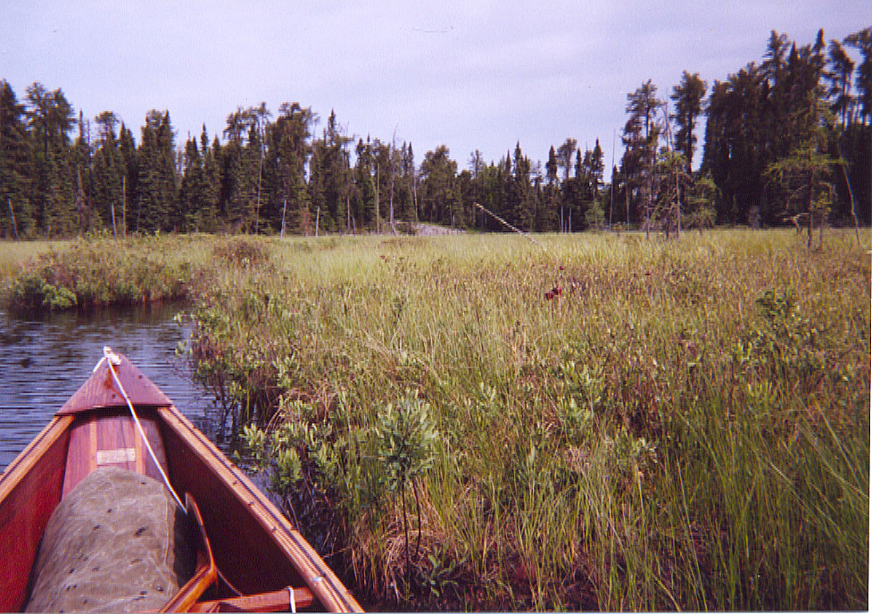
My 2002 trip into the southeast corner of Quetico would be a moderate one. I was unsure of how far I could paddle each day. Windy days that are tough on tandem paddlers might leave me on the shore. The route would be a loop from Gull Lake, at the end of the Gunflint Trail, through Saganaga and Cache Bay, down the Man Chain, through Prairie Portage and then back east through Louisa, McEwen and the top of the Falls Chain.
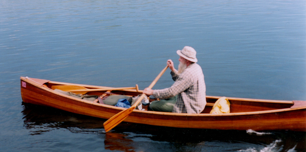
I would travel in a homemade cedar strip canoe of a Henry Rushton design(slightly modified). It is 15'x 30" and weighs 50 lbs with paddles, life vest and safety gear attached. I carried two paddles, one bent shaft the other straight. My outfit consists of 3 packs: a #2 Duluth Pack, a canvas military duffel and a day pack. The duffel rests easily on top of the Duluth Pack without having to hold on to it. I carry the day pack when portaging the canoe. Both loads started out about 60-65 lbs.
16 June Trails End, Gunflint Trail
After 2 1/2 days on the road, it was a relief to arrive at Way of the Wilderness Outfitters. A night in their bunkhouse allows me an early and hopefully windless start for Cache Bay tomorrow. Saganaga can be a rough passage, but I love the lake and would rather paddle it than use a motorized shuttle. The bunkhouse is comfortable and the café provided a good dinner and a few beers to help me get to sleep.
My outfit has been unpacked, checked and repacked, ready for the morning. I paddled for an hour in the long evening, comfortable in the solo Rushton. It is hard to get to sleep the night before jumping off and I am still awake in the twilight at 10:30.
Day 1, 17 June Gull-Saganagons 18.6 miles 1 portage
I was awake when the 4:15AM alarm went off. A shower cleared my head and got me moving. By 5AM I was drifting down the Sea Gull River, passing sleeping resorts, cabins and outfitters cloaked in a heavy fog. I threaded a familiar route through the islands. Saganaga was glassy when I came out of the islands to make the crossing to American Point. Two folks coming out from Cache Bay in solo canoes stopped to chat on the calm lake. We had all of Saganaga to ourselves! As I entered Cache Bay I could hear the morning shuttle dropping off folks at Hook Island far behind me. Janice was opening the office at 8AM as I arrived to get my permit.

I visited the Cache Bay pictographs to pay my respects and leave an offering of tobacco. I have brought along my fathers paddle, voyageur sash and toque to leave in the wilderness, a few words about his life carved on the paddle blade. I ask the powers of the place permission to leave these things down at the end of the long bay past the pictographs. No maymaygwayshi grabs my rail to tip me into the water, so I take it as a sign that this would be OK. An island in the center of the end of the bay is a beautiful place with red pines, dad’s favorites, and caribou lichen a foot thick. Nobody comes here. I lean the paddle on a tree and tie it there with the sash. The hat is placed over the grip of the paddle. Open to the wind and sun, they will disappear into the island in no time. I drift around the end of the bay for awhile thinking of all the times we spent together in this country and all the young men he introduced to canoe travel. I am finding it hard to paddle away. A gust of wind reminds me that traveling on the big water will get difficult if I tarry here much longer, so I spoon off down the narrow bay.
I headed north to Silver Falls and the only portage planned for today. The first portage always surprises my muscles, but I get across OK. A campsite opposite the Slate Lake portage provided a good stopping place. At 3PM I was too tired to start portaging into the Man Chain. I am still recovering from 2 1/2 days of driving.
The lakes are very low, 2-2.5 ft below last years high water mark. There are rock gardens everywhere and some portage and campsite landings are rough or muddy. The forest tent caterpillars and their "friendly" fly predators are at the peak of their cycle and are terrible. I hope that I can get used to them. I was very tired and lethargic when I stopped, but feel much better after a few hours in the shade.
Day, 2, 18 June Saganagons-This Man 10.5 miles 7 portages
This was a day of wilderness travel that I will never forget. I saw no people the entire day, unusual on the busy Man Chain. I shared the lakes and portages only with the wildlife. There were lots of otter families, especially near the outlets of streams. The young otters were especially curious about the canoe and approach rather close as the parents chattered at a distance. The seven portages and one lift over a beaver dam were a good workout, but went smoothly. The canoe works well in the wind and I paddled into it or quartered to it all day. It has an almost effortless cruising speed that is more than adequate. The outfit packs easily over the portages. I am already in the "groove".
I stayed at the prospector’s camp on This Man Lake. A good camp, rarely used, but almost too sheltered. Mosquitoes could be bad here without the strong breeze. Looks like a change in the weather tonight, and I expect rain by morning. A cloudy day would be welcome; I have had to stop often to get out of the sun.
Enjoying twilight on the rock at waters edge; breeze, loons and beaver on the lake, spruce and white pine silhouettes on the horizon. I am in my place.
Day 3, 19 June This Man-Carp 8 miles 3 portages
The day starts cloudy and breezy after rain during the night and moistened by bouts of mizzlin' rain. The clouds and moist air are pleasant after baking in the sun and dry wind for two days. The tall cliffs and headlands on the Man Chain are veiled in mist, easy on the eyes. The creek from No Man Lake to That Man Lake was navigable, the water level being not as low here as it was on the Maligne River lakes. I spent an hour floating down this creek. It is a wonderland. The portage from That Man to Sheridan is one of the prettiest I've seen with falls, ponds and rushing stream. A very nice falls at the Sheridan-Carp portage, too.

The storms brought heavy rain, hail and lightning, but not much wind, though it may not be over yet at 10PM. The hail made the water dance. Staying under the tarp was impossible. Storms in the lake country are always interesting to watch. As my dinner cooked under the tarp, I wandered about the camp visiting all the various viewpoints as the storm rolled over the lake. This was another fine day of wilderness travel. It is different traveling alone. I enjoy the quiet, the solitude and being able to steer off on any exploration without consultation. I do find that I am more sociable when I meet folks on the portages.
Day 4, 20 June Carp-Sunday 12 miles 3 portages

Three portages today: lower Knife River and Prairie portages were easy and busy, North portage to Sunday Lake was moderately difficult, but quiet. Carrying the canoe on Prairie portage I got confused by the tangle of trails on the upstream end. Without good visibility from under the canoe, I took the trail that seemed to be the most used, but ended up at the outhouse! Lots of people here. I spent a few moments talking to the shopkeeper at the Friends of Quetico store. The store is a good use for the abandon customs house.
Sunday Lake is gorgeous. I moved into the Hilton of island campsites with outcrops facing all directions, good cover and nice shady, sheltered tent sites. I know this site is heavily used, but it is CLEAN. I have seen no people since Green Island on Basswood. It seems I am alone on Sunday Lake. After 4 days of steady travel I am tired and moving slowly setting up camp and preparing dinner. Rum and cider are enjoyed each evening on some rock with a view as dinner cooks. This evening the view is from a comfortable ledge about 40 feet above the lake.
I have gotten to where I could take a day off, but will save that for nasty weather. Doing stretches before sleeping and again in the morning has kept back and neck stiffness and kinks at bay. I feel strong and steady on the portages, but I know there are hard ones ahead.
Day 5, 21 June Sunday-Louisa 8.5 miles 3 portages
I started slow after a poor nights sleep. There is no need to hurry anyway. Exploring the creek from Poacher Lake I found a portage trail around the falls at the bottom and it looks navigable upstream; a good prospect for a future adventure. The two longest portages of the trip, back to back, were very busy with friendly folks and "friendly" flies. The Sunday to Meadows portage has a long hill, but a pleasant place to rest at the top. There are huge trees here and I enjoy relaxing among them. The Meadow-Agnes portage was a trail of boulders with bad footing, but no hills or bogs. People I met on the portage were heading out early because they couldn't stand the flies. When I return to get my packs for the second stage of the portage, they are completely covered with flies, but it doesn't seem to bother me much any more.
I went to see the southern-most pictographs on Agnes Lake, but left the next ones north for another trip. The wind from the south had started up and I didn't want to battle it back up to Louisa Falls portage. It would have been a good day to be heading north on Agnes. The crowd had left the falls before I got there, ten canoes had been parked there when I paddled by earlier. It is an enchanting place if you have it to yourself. The portage is steep and dangerous going up, but would be much worse going down, especially with a canoe. I spent a long time visiting all the stages of the falls. I especially like the view from the top, looking over the falls to Agnes Lake down below.


Day 6, 22 June Louisa-Edge 7 miles 6 portages
On the water at 7:45AM and just in time, too. The wind and waves were already getting interesting as I reached the Louisa-Arp portage. The bogs on Star Lake and McEwen Creek upstream of Fauquier are fantastic. Lots of pitcher plants, swamp pink orchids, sundews and cottongrass. I spent hours poking around the bog edges. There were wolf tracks on two of the portages.
The Louisa-McEwen route is wonderful, but difficult. A couple of the portages are down right dangerous. I move carefully and deliberately on the portages, but I have no anxiety about traveling alone.
Day 7, 23 June Edge-McEwen 6 miles 4 portages
It stormed often during the night. I packed up slowly as the camp was very wet. I'll not be in a hurry today. It is cloudy, but not raining. I walked the loaded canoe down the creek out of Edge Lake, easy. Three more portages got me to Glacier lake, long and narrow surrounded by high hills and ridges. Some of the cliffs and headlands have talus slopes at the bottom - very different. One more portage and a runnable rapids made for an easy day. The remainder of McEwen Creek was another bog wonderland. I took several hours to float a couple of miles to the lake. The cloudy day turn misty while on the creek, making it all the more enchanting.
I stopped early at an island campsite in southern McEwen Lake with big red pines and a gravelly beach. The sun soon appeared with a good breeze. I dried the outfit thoroughly, bathed, swam and rinsed out my sweaty shirt. Clean body, hair and dry, clean clothes felt good after last nights storm camp. The sunset and moonrise were so nice I couldn't decide which side of the island to sit on. I ended up moving back and forth trying to elude the flies. This was another good day in the bush. I saw no people at all, but lots of loons, otters, eagles and another moose.
Day 8, 24 June McEwen-Saganagons 9.5 miles 4 portages
Awoke to early morning thunderstorms and went back to sleep. Got up at 9AM as the rain began to ease, had breakfast and a pot of tea, but still couldn't decipher the weather. The sun came through thin clouds about 10:30 and I dried the outfit and started out at noon.
The northern shorelines of McEwen Lake were burned in the Bird Lake fire, but this is still a beautiful big lake. On Wet lake, I saw the first people since the morning of the 22nd. Walking the loaded canoe down the Wet Lake-Maligne River rapids avoided a portage. Twelve Foot Falls on the Maligne River was a mess with campers. Gear was strewn all over the rocks and I had to pick my way through it to portage. I remember camping here in 1972 and how careful we were to keep our camp compact, neat and out of the way. The north side of the river and Saganagons lake is burned, but recovering fast.

Day 9, 25 June Saganagons-Saganaga 16.6 miles 1 portage
I had a nice morning exploring the Boundary Point area on Saganagons. I'll never use the shortcut portage again. This area is too pretty to miss and I'd rather paddle than portage. Silver Falls portage was easier this time, I'm in much better shape now. A large animal was crunching about in the woods just off the portage trail, but I didn't investigate. It sounded more like a bear than a moose. Later, at Cache Bay, the ranger told me that several parties had seen a bear on the portage, but it had yet to bother any food packs.
I got caught in a thunderstorm on the channel to Cache Bay, sitting it out on shore and watching it move away across the bay. A sprint across the bay to the ranger station got me there before a second storm approached. Sitting out the second storm at the ranger station, I visited with a group waiting to head out to Silver Falls and two boys who were separated from their group by the storm. I had planned to stop here on my way out to buy the book on the history of Quetico Park and with the stormy weather the station was a comfortable harbor.
When the storm passed I paddled out of Cache Bay and camped at a little site near the west side of the entrance to the bay. This site has been my last camp on several trips. I dried the packs, fixed dinner and then sat and read about Quetico history while enjoying the last of my rum and apple cider. Paddled out into Cache Bay to watch another grand sunset full of thunderheads, with rainbows to the south at the trailing edge of a storm. I am really not ready to leave tomorrow, and think another 10 days would suit me just fine.
Day 10, 26 June Cache Bay-Gull Lake 8.6 miles
The wind woke me up at 5:30AM. Packed up in a half an hour and got on the water. The wind was from the NW on Saganaga, so the paddle to Trails End was not too bad. It would have been worse if I had slept late. Groups headed out from Trails End had a rough day ahead, especially if paddling to Cache Bay. Arriving at Trails End at 9:30, I called home before loading the outfit in the car. They were still serving breakfast at Way of the Wilderness Outfitters, so I had pancakes and bacon with hot coffee. I felt awkward in the crowded café after sitting out in the open for 10 days, a sign of a good trip. The drive down the Gunflint Trail to Grand Marais was slow, stopping often to look at the blowdown areas. I was not really ready for the town scene. Lunch at the East Bay Hotel, cabin at Nelson's and a fine afternoon on the shore of Lake Superior. After dinner at the Angry Trout Café and a few beers at the Gunflint Tavern I went back out to Artist Point between the harbor and the lake. Lake Superior is so enchanting and I am able to scramble over some rock ledges that give me some solitude for awhile. The first day out of the bush is disorienting, so it feels good to stay in Grand Marais and not be driving hard for home. The bed does feel good!
Epilogue
The solo trip was very easy for me. It was not a lonely experience at all. The country flowed through me as much as I traveled through it. It continues to do that. I can conjure up almost any moment of the trip and enjoy it again. The rugged cliffs of the Man Chain, the solitude of McEwen Creek, the spectacular Falls of the Maligne River all become part of my day dreams.
105.3 miles on the map, probably paddled a bit more than that. 33 portages totaling 1668 rods = 5.21 miles
 Donate - BWCA.com