Hanging out north of the South Arm
by TuscaroraBorealis
I am up before my alarm goes off this morning. My bunkhouse (#2) is conveniently situated close to the restrooms, so I stroll over and get ready for the day. Shortly thereafter, (and because of the current Co-vid restrictions) Ada comes to my bunkhouse to deliver my takeout/boxed breakfast. It’s still a bit cool this morning so, I cheat a little and sit in my van with the heater on while I eat breakfast; which proves to be very tasty and filling. I am determined to try some new things for this trip so, I had ordered a chamomile tea to drink with breakfast. I had never tried one prior and was a little concerned; but find that, while different, it is still a quite acceptable drink.
Up to the office to pick up my permit, and then down to the suburban to meet Mark (my driver) and load up the suburban with my packs and The Black Pearl as I plan on getting towed across Saganaga Lake (EP #55) to start my trip. This being only the second day of legally allowing overnight visitors in the BWCA, I don’t expect too much competition for campsites until the weekend.
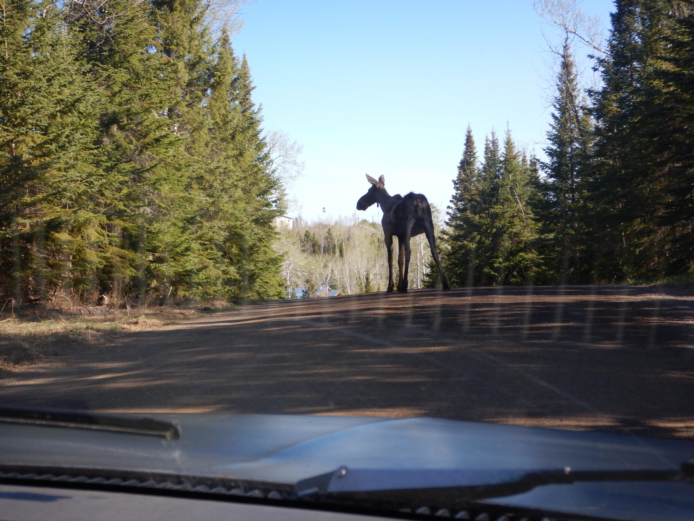
Just before we arrive at the landing we are compelled to stop as a moose is in the middle of the road licking the ground (presumably salt or something of the like). She is in no hurry but, neither are we, so we enjoy watching her for several minutes. Once we pull into the landing, there is a vehicle there waiting for us. I had forgotten my fresh meat in the cooler back at Tuscarora and Andy had called ahead to a nearby outfitter to give us/me a heads up. DOAH!!! So, much for remembering everything. We turn tail and head back, delayed briefly by the same persistent moose. Before we get too far back down the Gunflint Trail, Mark notices Ada speeding by and we stop to turn around. She also does a quick U-turn and hand delivers my small cooler. Just another reason why these guys (Tuscarora Outfitters) are so awesome! Back to the landing, and this time we get to see a fox trot across in front of us as the moose is just off the road undoubtedly peeved at our seemingly never-ending intrusions.
Saganaga is a sleeping giant this morning so we smoothly cut across the lake to American Point. There is another couple there unloading as we pull up. With the whole Co-vid thing I’m not sure what proper protocol is but, they are very friendly and chatty, and we have a cordial, unmasked, conversation while we load up our respective canoes in reasonably close quarters.
From a paddling perspective, I don’t think I could’ve ordered up a better day weather wise. Nary a cloud in the sky and only the slightest of breezes easing across the bright blue liquid expanse. My first portage into Swamp Lake isn’t too much more than a lift over, but it does necessitate getting out of the canoe; which does my aging body good after a reasonably long stretch of uninterrupted paddling through the ever constricting western end of beautiful Saganaga Lake.
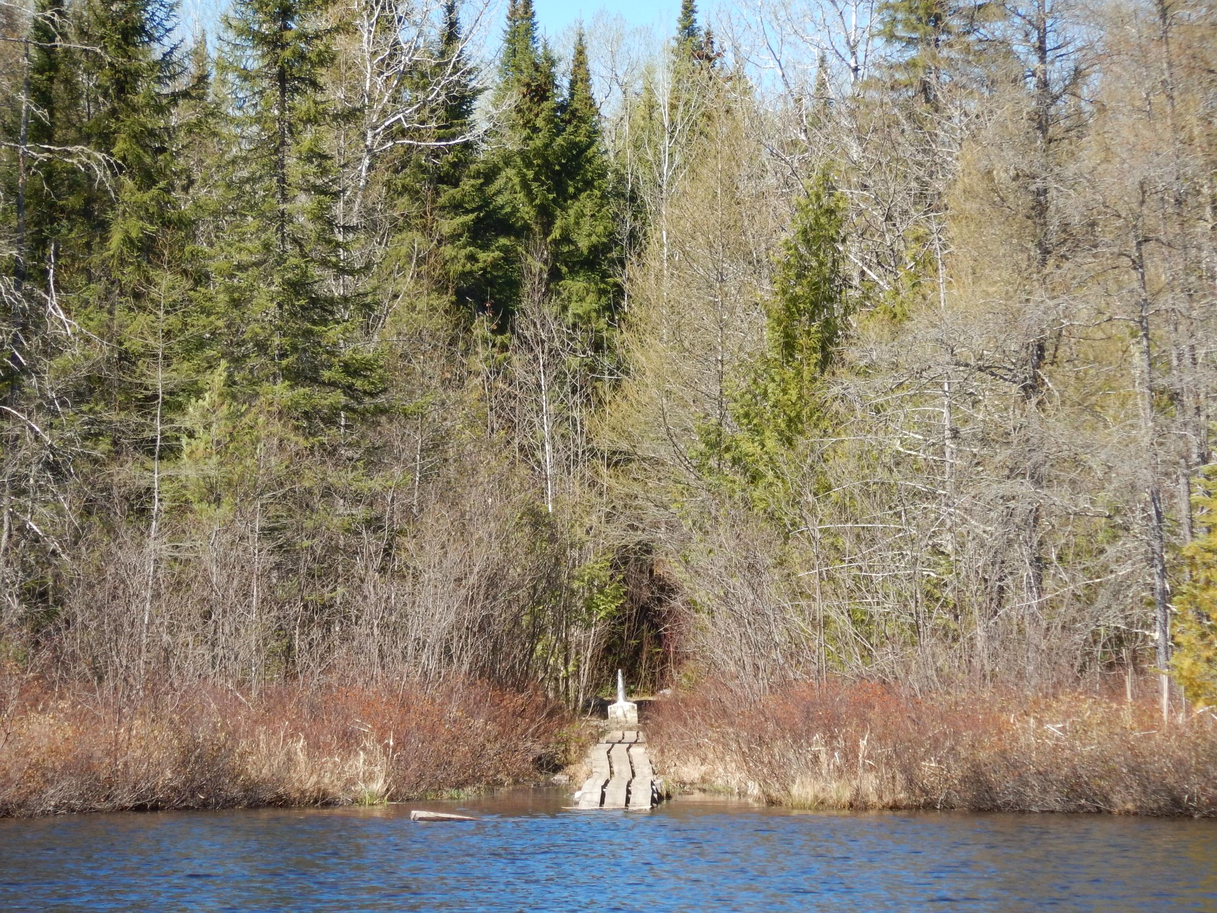
A short paddle later I am on to Monument Portage. This is certainly one of the more famous portages in canoe country. From Swamp, it starts out on a long boardwalk before transitioning into a decent path that does drop down to an expansive landing on Ottertrack Lake. Of note: along the way there are 3 large border obelisks (or “monuments”) just off the trail. Of course, there are countless smaller markers peppered all along the international boundary, but there is only a total of 9 of these large markers, of which 3 are located along this portage.


There is still extensive wind damage evident on the western hillside of Mud Bay with several trees bent or completely toppled over; and it is also quite shallow until I paddle through the narrows into the main body of Ottertrack lake. I pull into the peninsula campsite (#1996) to check it out. Even besides it being the only campsite for quite a distance in either direction along the Voyageurs highway, it is a very nice, accommodating, site.
As I push on through the pinch point of Ottertrack I need to favor the Canadian side where there is deeper water. Beautiful dramatic cliffs loom over various spots along the Canadian shore. Just before the lake broadens to the west, there is a neat sheer rock wall. Here is located a shrine to longtime resident Benny Ambrose, who lived in the bay just across the lake on the American side for many years. I’m sure there not, but there are some red stains on the cliffs that almost appear to be pictographs.


Benny passed away in 1982 but, remains of his cabin and residence are still visible. He isn’t as well-known as Dorothy Molter, and from what I know of him I think he would prefer it that way, but he too was a year round BWCA resident for several decades. You’ll know your pulling up to the right spot when you see the large rock crib below the surface just out from shore. Not sure if there's any significance to this but, interestingly, there is an old Budweiser can sunken here on top of the boulders. The trail running back to the cabin site is not super obvious, and it is a bit long, but is easily followed. It leads up to where his cabin was. There are several cemented footings, post holes as well as some artifacts (or garbage – depending on your perspective). It appears some may use this as an unofficial campsite as there is a makeshift boulder fire ring with charred remains inside. One thing that hasn’t changed since Benny was here is the breathtaking view west down Ottertrack Lake.


Next I paddle into the tiny back bay just south of the cabin site. There I find an old rusty hinge and, surprisingly, a well-worn trail back to the eastern side of the pinch point on Ottertrack. Not sure what purpose this serves or served? But obviously people must use this on a somewhat regular basis.
As I exit the bay and continue westward down the lake, I am captivated by the intense contrasting bright white expanse of an inland glacier against the lush green backdrop of the shoreline forest. It appears there is a small creek tumbling down into the lake here as the overhanging cedars keep this spot well shaded. I wonder if Benny was able to use this as his own personal ice machine into May and June back in the day?

Paddling on, I begin my search for the Gijikiki portage in earnest. It proves to be well concealed but, is located right where my Voyageur Map says it is. While the opening to the lake is quite small, the landing, just back in the woods, is spacious and has plenty of room for packs and canoe. The trail begins with a short quick ascent before turning west on something of a switchback. While not overly steep, the climb in this section still gets my blood pumping. Next the trail turns south, and the real fun begins. It is basically a vertical path from here to the summit. There is a neat rock cut at the top with a, presumably popular, large boulder that serves as a welcome resting spot. Just off the trail, on either side, sheer cliffs drop precipitously; confirming what my exhausted, racing heart is already well aware of. There is a short spur trail running west which provides a marginal overlook of Ottertrack Lake. Believe it or not, after continuing on, the next section is a succession of small mud holes. They are nothing too bad and the level ground is a welcome change; regardless of moisture content. Finally, the trail drops down to Gijikiki to a tight unaccommodating landing. These drops are nothing severe but, since they are all over large knobby rock faces, they have potential to be quite slippery. As I sit and catch my breath, I wonder to myself how often Benny Ambrose felt the desire to visit this ‘backyard’ lake?


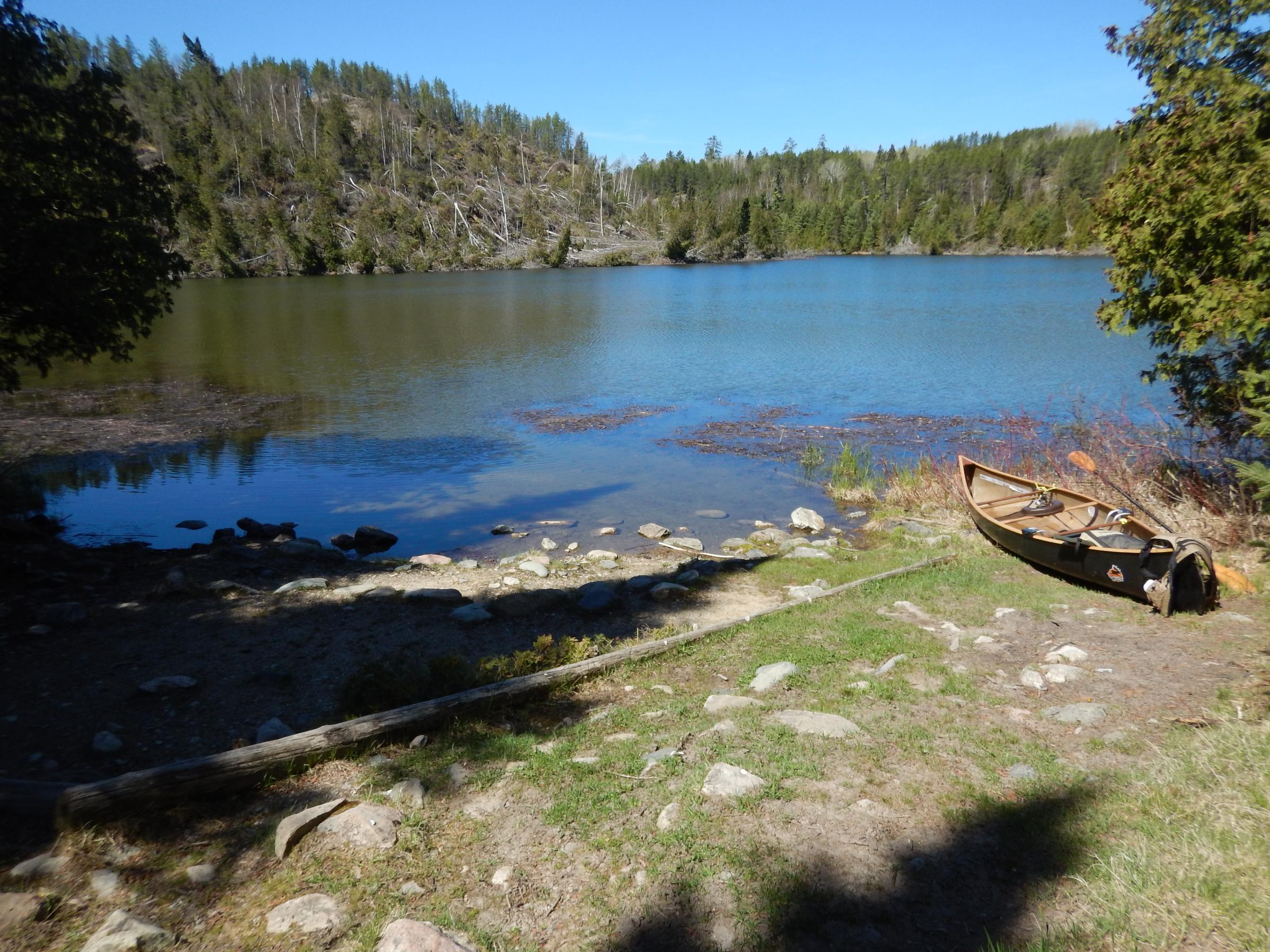
Gijikiki is a beautiful sight to behold for more than just being the end of a tough trail. I paddle over to the campsite (#320) just east of the portage to assess its potential as my home for the next couple of days. It is a well concealed and well shaded site with a small but workable landing. The log seating and fire grate could certainly use some work but, there are a couple of nice tent pads. A respectable fall back site if I need it.
As I paddle away, the water is shallow for quite a distance out from shore. Being a relatively small lake, it’s only a short paddle to check on the island site (#2007). This island site has a neat 25’ rock platform out in front which I can see provides a decent landing spot and will ably serve double duty as a great, slightly elevated, perch from which to fish from. The fire grate is well positioned, has great log seating and even has an old moose skull (with tiny horns) decoratively adorned at the front. There are trails running to the back of the site where there is a decent spot to best view sunsets and there are a lot of downed wood back here too. However, the tent pads are certainly not the best. They are either cramped or boulder/root filled or both. Still, being solo, it’s an awesome site and I am happy to claim it.

The weather is supposed to continue being decent for the foreseeable future so, I forego setting up my CCS tarp. Besides, there’s some nice mature trees providing shade and shelter around the kitchen area. The resident beaver swims by to check me out as I finish getting camp set up. I end up cramming my tent in the spot right near shore. Not the most convenient entry but, it does offer the flattest tent pad.

With camp up, I take full advantage of the rock shelf and relax with some extremely convenient shore fishing. Later, after supper, I enjoy the silent company of a clear, starlit evening and its Creator before retiring. Things really went well today and I’m grateful to be able to be back in canoe country! ~Saganaga Lake, Swamp Lake, Ottertrack Lake, Gijikiki Lake
 Donate - BWCA.com